Park Forest is a village located south of Chicago in Cook County, Illinois, with a small southern portion in Will County, Illinois, United States. The village was originally designed as a planned community for veterans returning from World War II. As of the 2020 census, the village had a population of 21,687. Park Forest has multiple public and private schools. In addition to the arts and culture scene including Tall Grass Arts Association and the Illinois Theatre Center, residents also have access to a myriad of recreational opportunities for both children and adults such as the Park Forest Aqua Center. Notable people from Park Forest include the former artistic director of the Illinois Theatre Center, Etel Billig. Park Forest is bordered by Olympia Fields to the north, Chicago Heights to the east, University Park to the south, and Richton Park and Matteson to the west.
| Name: | Park Forest village |
|---|---|
| LSAD Code: | 47 |
| LSAD Description: | village (suffix) |
| State: | Illinois |
| County: | Cook County, Will County |
| Elevation: | 712 ft (217 m) |
| Total Area: | 4.96 sq mi (12.85 km²) |
| Land Area: | 4.96 sq mi (12.85 km²) |
| Water Area: | 0.00 sq mi (0.00 km²) |
| Total Population: | 21,687 |
| Population Density: | 4,371.50/sq mi (1,687.74/km²) |
| Area code: | 708 |
| FIPS code: | 1757732 |
| Website: | www.villageofparkforest.com |
Online Interactive Map
Click on ![]() to view map in "full screen" mode.
to view map in "full screen" mode.
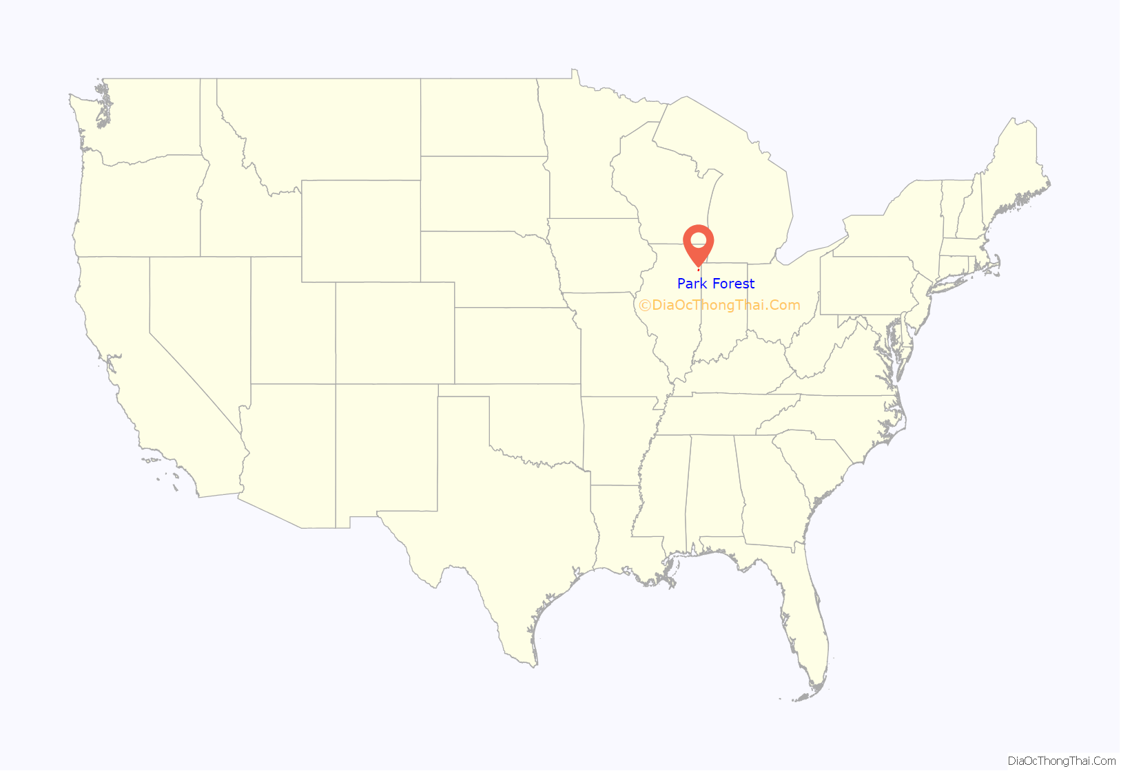
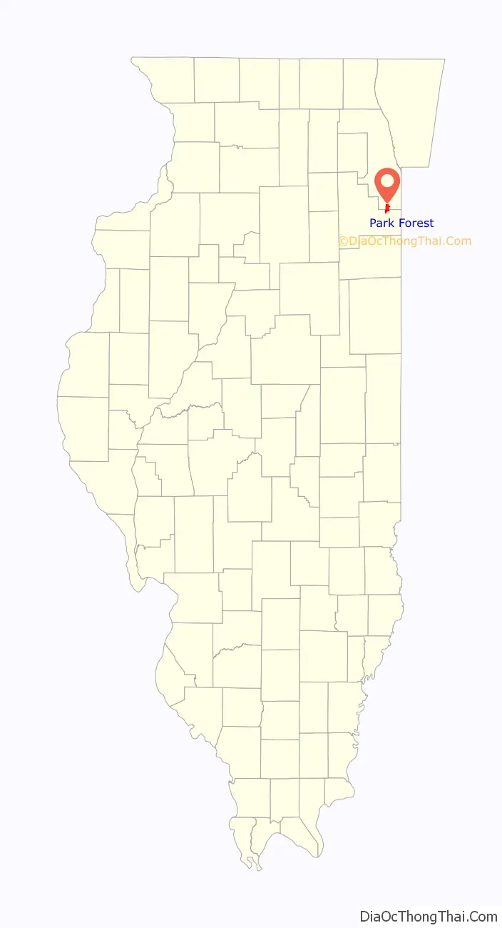
Park Forest location map. Where is Park Forest village?
History
Developers Nathan Manilow, Carroll F. Sweet and Philip M. Klutznick held a press conference in the Palmer House in Chicago on October 28, 1946, to announce the planned development of a new self-governing community in Chicago’s south suburbs. This project, soon to be referred to as Park Forest, was to be developed by American Community Builders (ACB). The village of Park Forest was partly designed by town planner Elbert Peets in the tradition of planned communities around the nation to provide housing for veterans returning from World War II.
Studs Terkel, in his oral history of World War II, The Good War, says Park Forest and other such middle-class suburbs grew out of the new prosperity after the war. First he quotes an unnamed GI, “The war changed our whole idea of how we wanted to live when we came back. We set our sights pretty high. . . . I am now what you’d call middle class.” Terkel goes on: “The suburb, until [about 1946], had been the exclusive domain of the ‘upper class.’ It was where the rich lived. The rest of us were neighborhood folk. At war’s end, a new kind of suburb came into being. . . . Thanks to the GI bill, two new names were added to American folksay: Levittown and Park Forest.
“A new middle class had emerged. Until now, the great many, even before the Depression, had had to scuffle from one payday to the next. . . . [Before there had only been one] car on the block. Now everybody was getting a car. Oh, it was exciting. (Terkel, p. 12)”
Park Forest was honored in 1954 as an “All-America City” for its citizens’ help in the creation of Rich Township High School, on Sauk Trail. It was awarded this same honor again in 1976 for open housing and racial integration and initiatives. A village landmark was the Park Forest Plaza, an outdoor regional shopping center of over 50 stores and restaurants which included Sears, Marshall Fields and Goldblatt’s.
In 1956, William H. Whyte, an editor at Fortune magazine, published a book called The Organization Man that defined the nature of corporate life for a generation. The book described how America (whose people, he said, had “led in the public worship of individualism”) had recently turned into a nation of employees who “take the vows of organization life” and who had become “the dominant members of our society”. Park Forest was one of the communities that figured most prominently in Whyte’s study of the home life of “the organization man,” and should be read by anyone seeking an insight into early Park Forest.
In 1951 and 1957, synagogues opened in Park Forest as Jews became 15% of the population. By 2013, both synagogues had moved outside the town. Although officially desegregated from its inception, Park Forest’s first African-American family took residence there in 1959.
Park Forest is known for the “Scenic 10”, a 10-mile (16 km) race held annually on Labor Day that attracts runners from around the globe. In 2008, the race was shortened to a 5-mile (8.0 km) course to attract more local runners and renamed the “Scenic Five”.
On March 26, 2003, a meteor exploded over the Midwest, showering Park Forest with dozens of meteorite fragments. These fragments are currently on display at the Field Museum in Chicago. For further reading see Park Forest (meteorite).
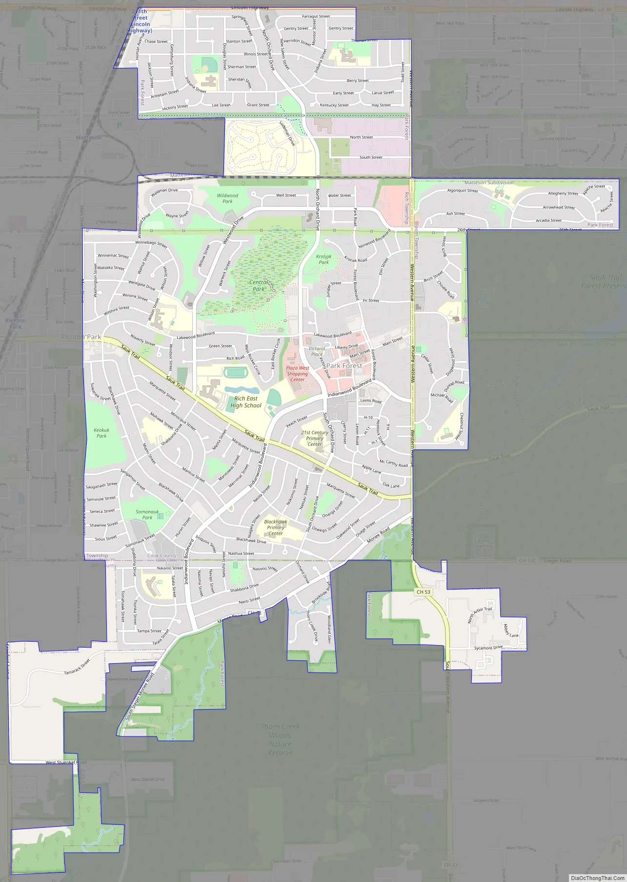
Park Forest Road Map
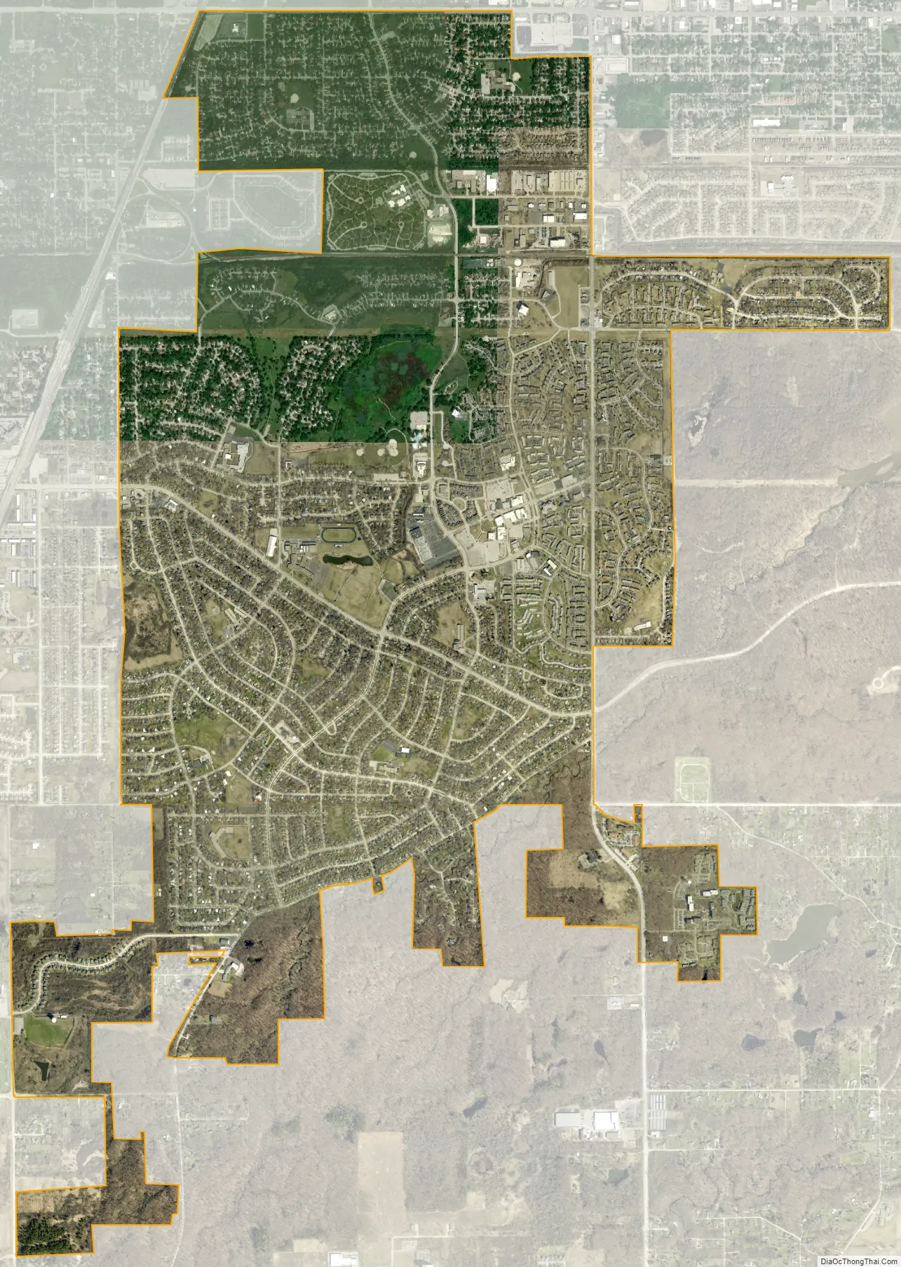
Park Forest city Satellite Map
Geography
According to the 2021 census gazetteer files, Park Forest has a total area of 4.96 square miles (12.85 km), all land.
The village is generally bounded by U.S. Highway 30 on the north, Western Avenue on the east, Central Park Avenue on the west and Thorn Creek on the south. Parts of Park Forest are east of Western Avenue, however, including a subdivision called “Eastgate”. Park Forest is bisected by the Elgin, Joliet and Eastern Railway (now the Canadian National Railway) double-track main line, which was paralleled a little further north by the Michigan Central (New York Central) railroad. That rail line has been converted to a nature trail called Old Plank Trail. The beginning of the trail is at Western Avenue, and it runs through Park Forest west to Joliet.
Climate
See also
Map of Illinois State and its subdivision:- Adams
- Alexander
- Bond
- Boone
- Brown
- Bureau
- Calhoun
- Carroll
- Cass
- Champaign
- Christian
- Clark
- Clay
- Clinton
- Coles
- Cook
- Crawford
- Cumberland
- De Kalb
- De Witt
- Douglas
- Dupage
- Edgar
- Edwards
- Effingham
- Fayette
- Ford
- Franklin
- Fulton
- Gallatin
- Greene
- Grundy
- Hamilton
- Hancock
- Hardin
- Henderson
- Henry
- Iroquois
- Jackson
- Jasper
- Jefferson
- Jersey
- Jo Daviess
- Johnson
- Kane
- Kankakee
- Kendall
- Knox
- La Salle
- Lake
- Lake Michigan
- Lawrence
- Lee
- Livingston
- Logan
- Macon
- Macoupin
- Madison
- Marion
- Marshall
- Mason
- Massac
- McDonough
- McHenry
- McLean
- Menard
- Mercer
- Monroe
- Montgomery
- Morgan
- Moultrie
- Ogle
- Peoria
- Perry
- Piatt
- Pike
- Pope
- Pulaski
- Putnam
- Randolph
- Richland
- Rock Island
- Saint Clair
- Saline
- Sangamon
- Schuyler
- Scott
- Shelby
- Stark
- Stephenson
- Tazewell
- Union
- Vermilion
- Wabash
- Warren
- Washington
- Wayne
- White
- Whiteside
- Will
- Williamson
- Winnebago
- Woodford
- Alabama
- Alaska
- Arizona
- Arkansas
- California
- Colorado
- Connecticut
- Delaware
- District of Columbia
- Florida
- Georgia
- Hawaii
- Idaho
- Illinois
- Indiana
- Iowa
- Kansas
- Kentucky
- Louisiana
- Maine
- Maryland
- Massachusetts
- Michigan
- Minnesota
- Mississippi
- Missouri
- Montana
- Nebraska
- Nevada
- New Hampshire
- New Jersey
- New Mexico
- New York
- North Carolina
- North Dakota
- Ohio
- Oklahoma
- Oregon
- Pennsylvania
- Rhode Island
- South Carolina
- South Dakota
- Tennessee
- Texas
- Utah
- Vermont
- Virginia
- Washington
- West Virginia
- Wisconsin
- Wyoming


