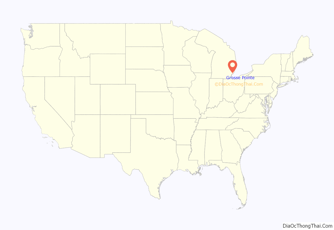
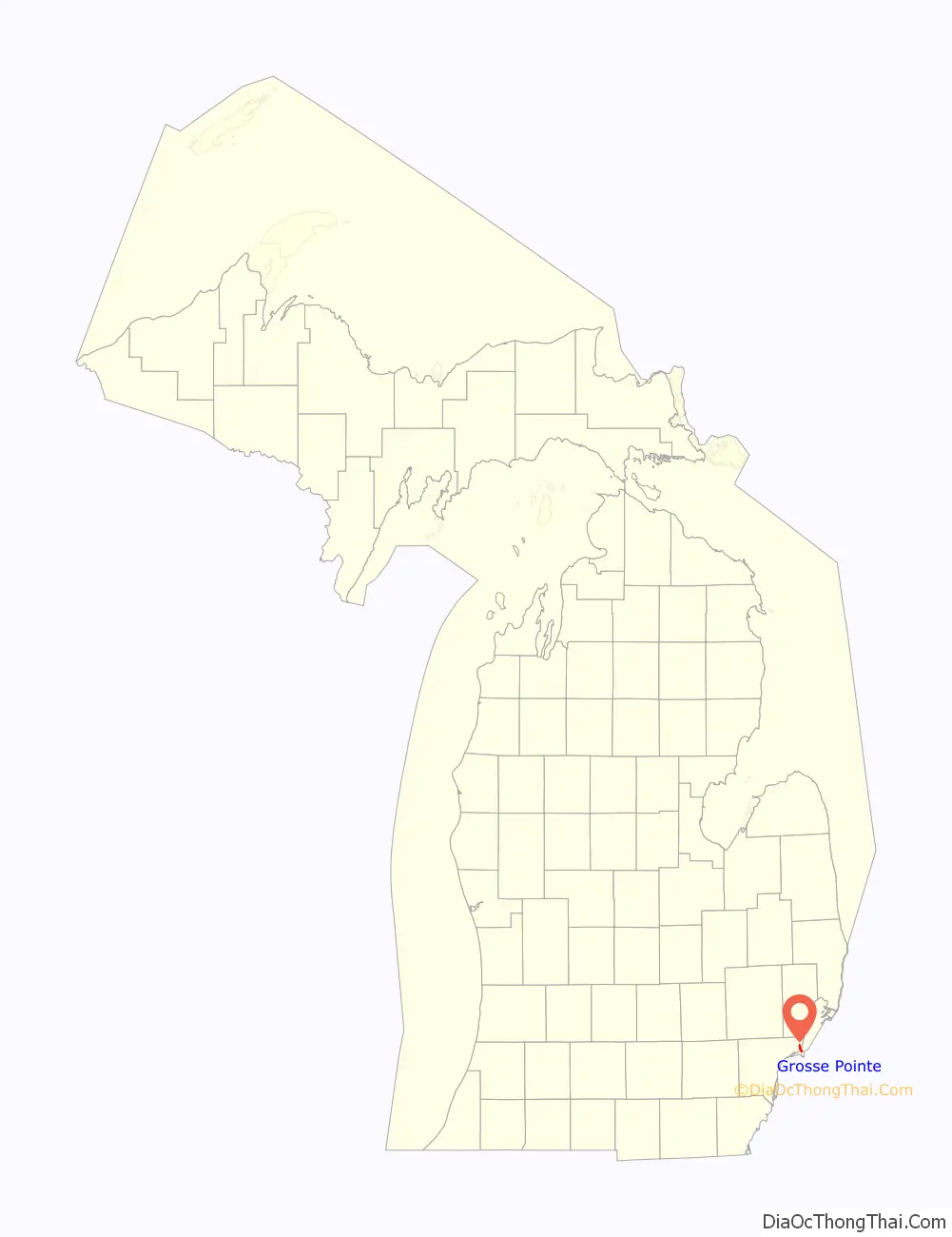
Grosse Pointe is a city in Wayne County in the U.S. state of Michigan. As of the 2010 census, the city had a population of 5,421.
Grosse Pointe is an eastern suburb of Metro Detroit along Lake St. Clair. It is located along East Jefferson Avenue and shares a small northwestern border with the city of Detroit. It is one of five cities within the Grosse Pointe area. Grosse Pointe was originally incorporated as a village in 1880 and again as a city in 1934.
| Name: | Grosse Pointe city |
|---|---|
| LSAD Code: | 25 |
| LSAD Description: | city (suffix) |
| State: | Michigan |
| County: | Wayne County |
| Incorporated: | 1880 (village) 1934 (city) |
| Elevation: | 587 ft (179 m) |
| Land Area: | 1.06 sq mi (2.75 km²) |
| Water Area: | 1.19 sq mi (3.09 km²) |
| Population Density: | 5,346.52/sq mi (2,064.33/km²) |
| Area code: | 313 |
| FIPS code: | 2635480 |
| GNISfeature ID: | 0627461 |
Online Interactive Map
Click on ![]() to view map in "full screen" mode.
to view map in "full screen" mode.
Grosse Pointe location map. Where is Grosse Pointe city?
History
It was incorporated as a city in 1934. There are five Grosse Pointes: Grosse Pointe Park, Grosse Pointe City, Grosse Pointe Farms, Grosse Pointe Woods and Grosse Pointe Shores.
Together with Grosse Pointe Park and Grosse Pointe Farms, the city comprises part of the southern Pointes, which are older and more densely populated than the northern Pointes (Grosse Pointe Woods and Grosse Pointe Shores). It became heavily populated between 1910 and 1930 as one of Detroit’s first commuter suburbs; in the previous century, Grosse Pointe was home to cottages, resorts, farms, and widely spaced lakefront mansions. Grosse Pointe (“the City”), Grosse Pointe Farms, and Grosse Pointe Park make up the Grosse Pointe South High School district. Grosse Pointe Woods and Grosse Pointe Shores make up the Grosse Pointe North High School district. Downtown Grosse Pointe, along Kercheval Avenue from Neff to Cadieux, nicknamed “The Village,” is considered by many locals to be the central downtown for all five of the Grosse Pointes, although each of them (except Grosse Pointe Shores) has several blocks of retail properties.
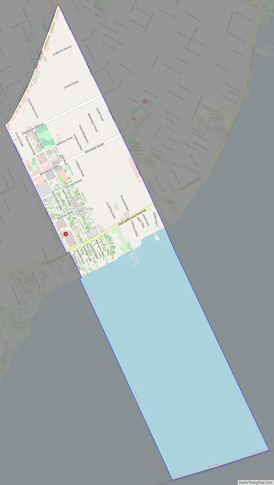
Grosse Pointe Road Map
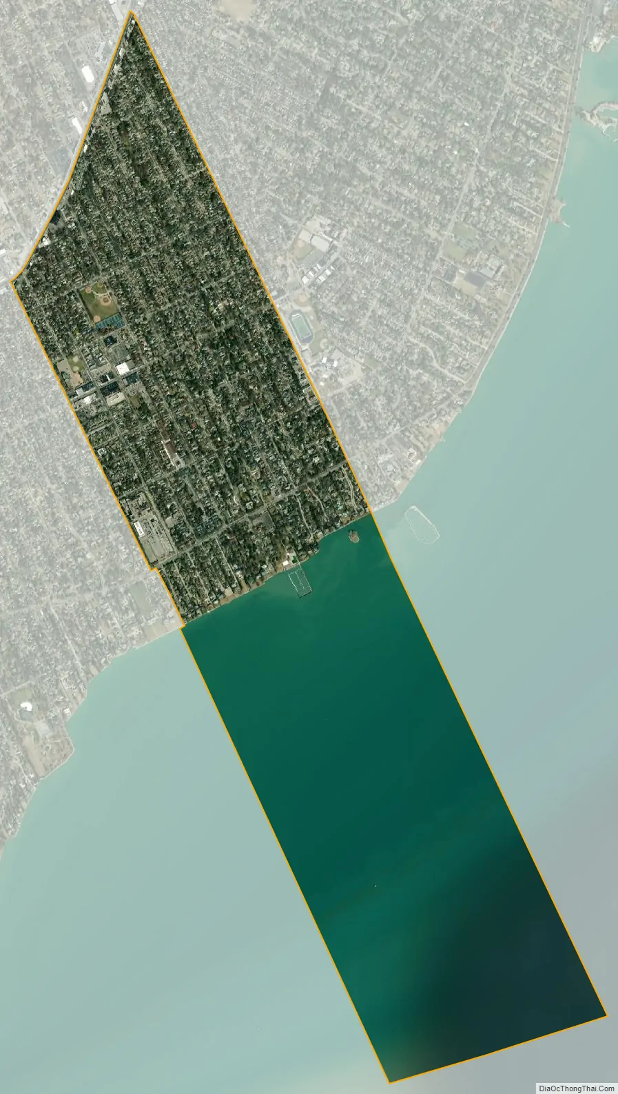
Grosse Pointe city Satellite Map
Geography
According to the United States Census Bureau, the city has a total area of 2.25 square miles (5.83 km), of which 1.06 square miles (2.75 km) is land and 1.19 square miles (3.08 km) is water. The water is part of Lake St. Clair.
The street layout of Grosse Pointe is basically a grid inside of its Cadieux, Mack, and Fisher Road boundaries. Inside this small rectangle, most blocks contain rows of single-family homes built between 1910 and 1950, on parcels 50 feet (15 m) wide on average. Some streets offer large backyards, such as Washington and Lakeland, while other streets are more compact. In some areas, homes are configured in a traditionally urban, close-together fashion, while other nearby blocks may offer yards up to 150 feet (46 m) wide.
Home sizes and styles vary widely, from 1,500 to 12,000 square feet (140 to 1,110 m), but slightly under 3,000 square feet (280 m) on average. Most of the largest homes are within a few blocks of the lakefront; there are several blocks of mansions south of Kercheval Avenue. Predominant architecture includes the neo-Georgian, Tudor revival, Dutch Colonial, and arts and crafts styles. Some Victorian homes and traditional bungalow homes can also be found, mostly just north and south of the Village retail district. Some blocks, generally just south of the Village, have townhouses and apartments. Most of these were built in the 1920s, and can be seen along St. Paul, Maumee, and Jefferson avenues, mostly west of Rivard Boulevard, and between Notre Dame and Cadieux south of the Village retail district.
There are retail and low-rise office buildings along Kercheval Avenue in the Village district, on Fisher Road near Grosse Pointe South High School, and along Mack Avenue bordering Detroit.
See also
Map of Michigan State and its subdivision:- Alcona
- Alger
- Allegan
- Alpena
- Antrim
- Arenac
- Baraga
- Barry
- Bay
- Benzie
- Berrien
- Branch
- Calhoun
- Cass
- Charlevoix
- Cheboygan
- Chippewa
- Clare
- Clinton
- Crawford
- Delta
- Dickinson
- Eaton
- Emmet
- Genesee
- Gladwin
- Gogebic
- Grand Traverse
- Gratiot
- Hillsdale
- Houghton
- Huron
- Ingham
- Ionia
- Iosco
- Iron
- Isabella
- Jackson
- Kalamazoo
- Kalkaska
- Kent
- Keweenaw
- Lake
- Lake Hurron
- Lake Michigan
- Lake St. Clair
- Lake Superior
- Lapeer
- Leelanau
- Lenawee
- Livingston
- Luce
- Mackinac
- Macomb
- Manistee
- Marquette
- Mason
- Mecosta
- Menominee
- Midland
- Missaukee
- Monroe
- Montcalm
- Montmorency
- Muskegon
- Newaygo
- Oakland
- Oceana
- Ogemaw
- Ontonagon
- Osceola
- Oscoda
- Otsego
- Ottawa
- Presque Isle
- Roscommon
- Saginaw
- Saint Clair
- Saint Joseph
- Sanilac
- Schoolcraft
- Shiawassee
- Tuscola
- Van Buren
- Washtenaw
- Wayne
- Wexford
- Alabama
- Alaska
- Arizona
- Arkansas
- California
- Colorado
- Connecticut
- Delaware
- District of Columbia
- Florida
- Georgia
- Hawaii
- Idaho
- Illinois
- Indiana
- Iowa
- Kansas
- Kentucky
- Louisiana
- Maine
- Maryland
- Massachusetts
- Michigan
- Minnesota
- Mississippi
- Missouri
- Montana
- Nebraska
- Nevada
- New Hampshire
- New Jersey
- New Mexico
- New York
- North Carolina
- North Dakota
- Ohio
- Oklahoma
- Oregon
- Pennsylvania
- Rhode Island
- South Carolina
- South Dakota
- Tennessee
- Texas
- Utah
- Vermont
- Virginia
- Washington
- West Virginia
- Wisconsin
- Wyoming


