River Rouge (/rɪˈvɜːr ruːʒ/, French: Rivière Rouge, lit. ‘red river’) is a city in Wayne County in the U.S. state of Michigan. The population was 7,224 at the 2020 census.
The city is named after the River Rouge, which flows along the city’s northern border and into the Detroit River. The city includes the heavily industrialized Zug Island and also has its own school district, River Rouge School District.
| Name: | River Rouge city |
|---|---|
| LSAD Code: | 25 |
| LSAD Description: | city (suffix) |
| State: | Michigan |
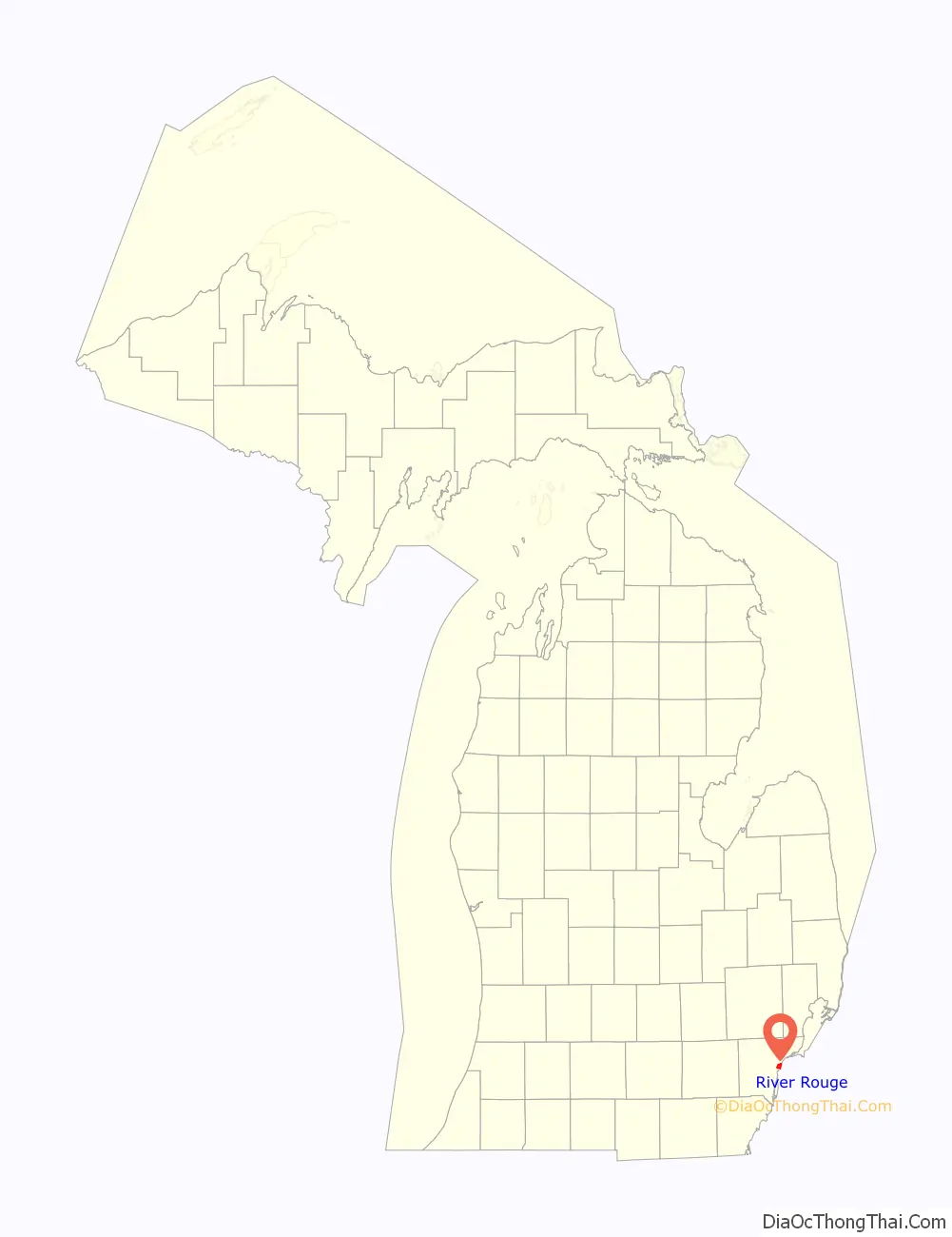
| County: | Wayne County |
| Incorporated: | 1899 (village) 1922 (city) |
| Elevation: | 584 ft (178 m) |
| Land Area: | 2.65 sq mi (6.87 km²) |
| Water Area: | 0.59 sq mi (1.54 km²) |
| Population Density: | 2,721.93/sq mi (1,050.85/km²) |
| Area code: | 313 |
| FIPS code: | 2668760 |
| GNISfeature ID: | 635965 |
Online Interactive Map
Click on ![]() to view map in "full screen" mode.
to view map in "full screen" mode.
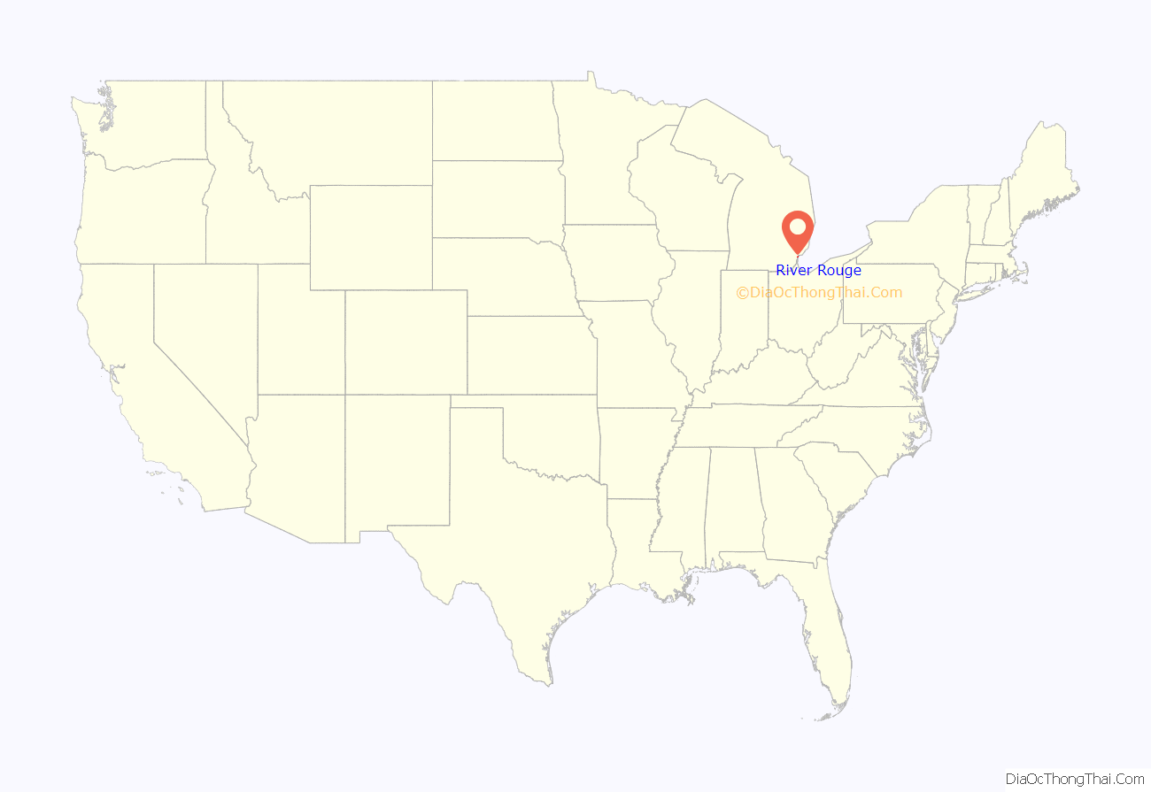
River Rouge location map. Where is River Rouge city?
History
The small settlement incorporated as a village in 1899 within Ecorse Township. In 1922 as the city of Detroit expressed interest in annexing land in the township, the Village of River Rouge incorporated as a city on April 3 to avoid being annexed. A month later Detroit completed annexation of land in the township immediately to the west of River Rouge.
One of the most important historical associations with River Rouge is its relationship to a Great Lakes freighter, the SS Edmund Fitzgerald, which sank in 1975 in a fierce storm in Lake Superior, with the loss of all 29 crew. The ship was constructed in 1958 at the Great Lakes Engineering Works in River Rouge and was the largest ship on the lakes at the time.
The city had its peak of population in 1950, when industry was the mainstay of the local economy. Restructuring of heavy industry and movement of jobs offshore have taken a toll of the city; the loss of jobs resulted in loss of population. In 2015 the population is less than half of what it was in 1950. Many workers who had the flexibility to seek jobs in other areas moved away. Outward migration has resulted in a shift in the racial demographics of the city.
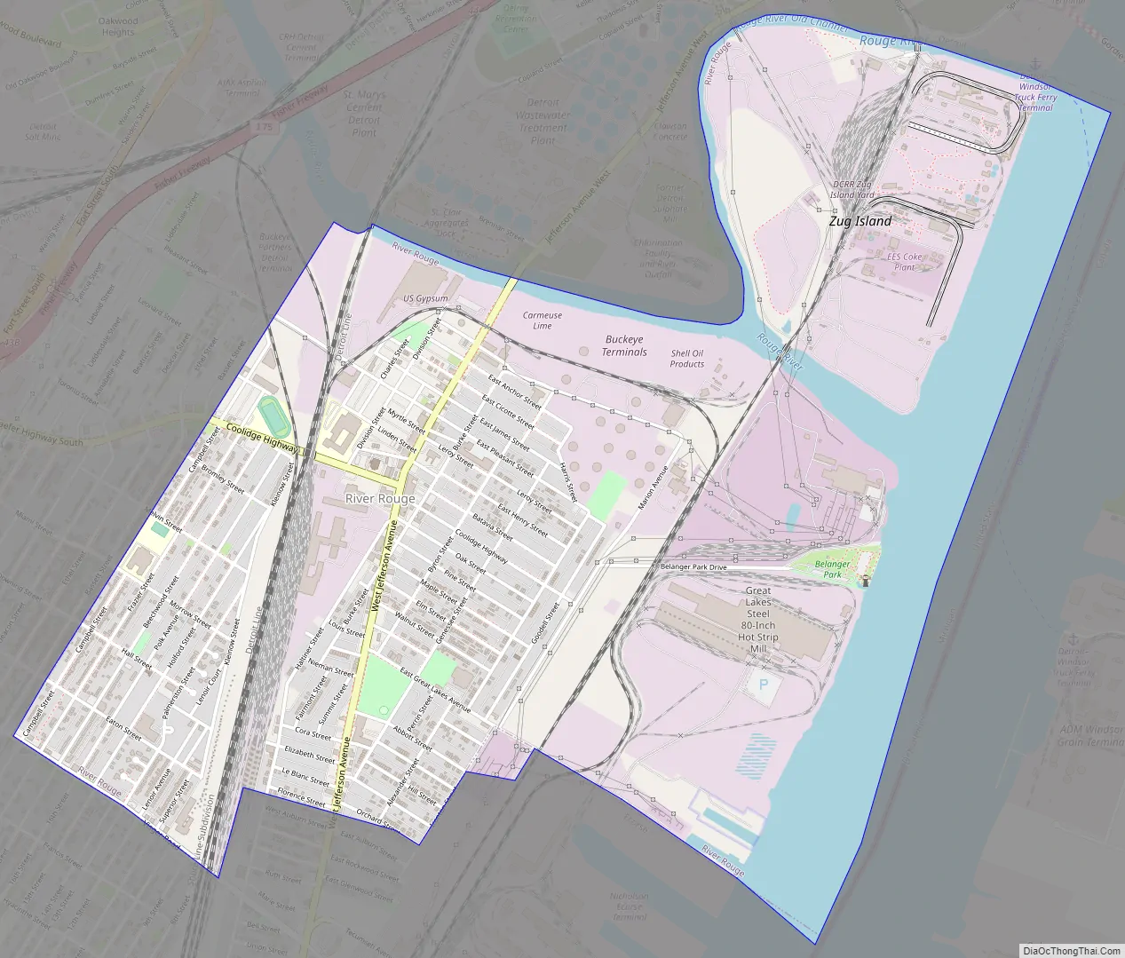
River Rouge Road Map
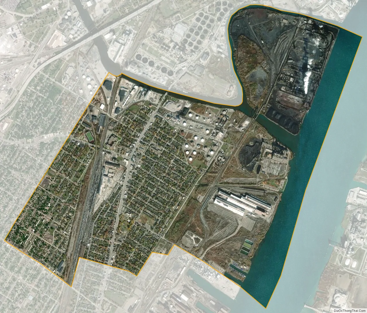
River Rouge city Satellite Map
Geography
According to the United States Census Bureau, the city has a total area of 3.24 square miles (8.39 km), of which 2.65 square miles (6.86 km) is land and 0.59 square miles (1.53 km) is water.
Of the city’s land area, 0.93 square miles (2.41 km) consists of the unpopulated Zug Island. The River Rouge forms the northern boundary with the city of Detroit, and the Detroit River forms the eastern boundary of the city. The Mariners Memorial Light is an active lighthouse located within the city along the Detroit River. Built in 2004, it is located within Belanger Park and is the newest constructed lighthouse in the state of Michigan.
River Rouge contains its own post office located at 10455 West Jefferson Avenue. The post office uses the 48218 ZIP Code, which covers most of River Rouge and a small section of the city of Ecorse to the south. Zug Island uses the Detroit 48209 ZIP Code.
See also
Map of Michigan State and its subdivision:- Alcona
- Alger
- Allegan
- Alpena
- Antrim
- Arenac
- Baraga
- Barry
- Bay
- Benzie
- Berrien
- Branch
- Calhoun
- Cass
- Charlevoix
- Cheboygan
- Chippewa
- Clare
- Clinton
- Crawford
- Delta
- Dickinson
- Eaton
- Emmet
- Genesee
- Gladwin
- Gogebic
- Grand Traverse
- Gratiot
- Hillsdale
- Houghton
- Huron
- Ingham
- Ionia
- Iosco
- Iron
- Isabella
- Jackson
- Kalamazoo
- Kalkaska
- Kent
- Keweenaw
- Lake
- Lake Hurron
- Lake Michigan
- Lake St. Clair
- Lake Superior
- Lapeer
- Leelanau
- Lenawee
- Livingston
- Luce
- Mackinac
- Macomb
- Manistee
- Marquette
- Mason
- Mecosta
- Menominee
- Midland
- Missaukee
- Monroe
- Montcalm
- Montmorency
- Muskegon
- Newaygo
- Oakland
- Oceana
- Ogemaw
- Ontonagon
- Osceola
- Oscoda
- Otsego
- Ottawa
- Presque Isle
- Roscommon
- Saginaw
- Saint Clair
- Saint Joseph
- Sanilac
- Schoolcraft
- Shiawassee
- Tuscola
- Van Buren
- Washtenaw
- Wayne
- Wexford
- Alabama
- Alaska
- Arizona
- Arkansas
- California
- Colorado
- Connecticut
- Delaware
- District of Columbia
- Florida
- Georgia
- Hawaii
- Idaho
- Illinois
- Indiana
- Iowa
- Kansas
- Kentucky
- Louisiana
- Maine
- Maryland
- Massachusetts
- Michigan
- Minnesota
- Mississippi
- Missouri
- Montana
- Nebraska
- Nevada
- New Hampshire
- New Jersey
- New Mexico
- New York
- North Carolina
- North Dakota
- Ohio
- Oklahoma
- Oregon
- Pennsylvania
- Rhode Island
- South Carolina
- South Dakota
- Tennessee
- Texas
- Utah
- Vermont
- Virginia
- Washington
- West Virginia
- Wisconsin
- Wyoming


