Arlington Heights is a municipality in Cook County in the U.S. state of Illinois. A suburb of Chicago, it lies about 25 miles (40 km) northwest of the city’s downtown. Per the 2020 Census, the population was 77,676. Per the 2010 Census, it is the most populous community in the United States that is incorporated as a “village”, and is the 13th most populous municipality in Illinois, although it is not far ahead of its nearby Illinois neighboring villages of Schaumburg and adjacent Palatine.
Arlington Heights is known for the former Arlington Park Race Track, home of the Arlington Million, a Breeders’ Cup qualifying event; it also hosted the Breeders’ Cup World Thoroughbred Championships in 2002. The village is also home to the Arlington Heights Memorial Library, which has one of the largest collections of books in the state.
| Name: | Arlington Heights village |
|---|---|
| LSAD Code: | 47 |
| LSAD Description: | village (suffix) |
| State: | Illinois |
| County: | Cook County, Lake County |
| Incorporated: | 1887 |
| Elevation: | 702 ft (214 m) |
| Total Area: | 16.64 sq mi (43.09 km²) |
| Land Area: | 16.61 sq mi (43.01 km²) |
| Water Area: | 0.03 sq mi (0.08 km²) |
| Total Population: | 77,676 |
| Population Density: | 4,677.87/sq mi (1,806.10/km²) |
| Area code: | 847 and 224 |
| FIPS code: | 1702154 |
| Website: | www.vah.com |
Online Interactive Map
Click on ![]() to view map in "full screen" mode.
to view map in "full screen" mode.
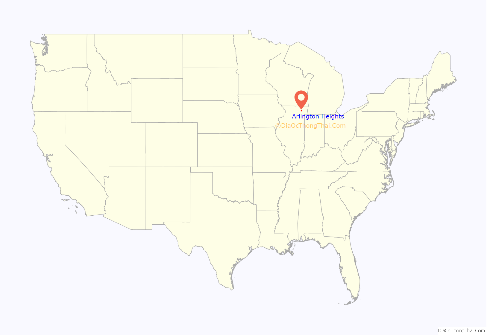
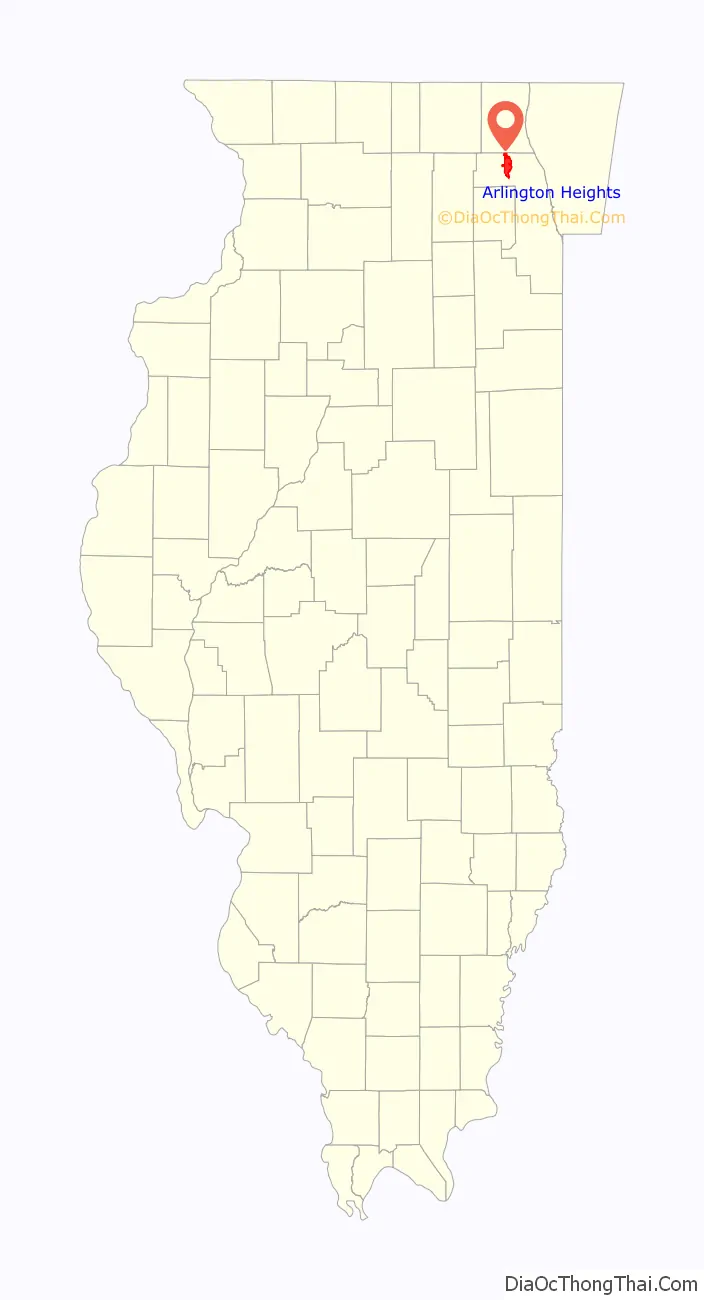
Arlington Heights location map. Where is Arlington Heights village?
History
Arlington Heights lies mostly in the western part of Wheeling Township, with territory in adjacent Elk Grove and Palatine townships, in an area originally notable for the absence of groves and trees.
Pre-Settlement History
The land that is now the Village of Arlington Heights was controlled by the Miami Confederacy (which contained the Illini and Kickapoo tribes) starting in the early 1680s. The Confederacy was driven from the area by the Iroquois and Fox in the early 1700s.
The French-allied Potawatomi began to raid and take possession of Northern Illinois in the 1700s. In the late 1700s and early 1800s, the Potawatomi expanded southwards from their territory in Green Bay and westward from their holdings near Detroit, until they controlled in an L-shaped swath of territory from Green Bay to the Illinois River, and from the Mississippi River to the Maumee River.
Throughout the 1830s, the Potawatomi maintained a camp in modern-day Arlington Heights that was used for six weeks out of the year as the Potawatomi migrated from their summer encampments to their winter encampments.
In 1833, the Potawatomi signed the 1833 Treaty of Chicago with the United States Government. As a result of the Treaty, the United States was granted control of all land west of Lake Michigan and east of Lake Winnebago in exchange for a tract of land west of the Mississippi. The land that is now Arlington Heights was ceded to the U.S. in this treaty, which sparked mass white immigration to the Northern Illinois area. The U.S. Government purchased the land for about 15 cents per acre, and then resold it to white settlers for 1.25 dollars per acre.
The Potawatomi would occasionally return to their holdings in Northern Illinois to honor their buried ancestors, but these return visits ended as old villages and burial sites were destroyed by settlers to make way for farming.
The descendants of the Potawatomi who once inhabited the land that is now Arlington Heights currently live on a reservation in Mayette, Kansas.
West Wheeling
Many prominent roads in the Arlington Heights area were built on top of Native American trails: Rand Road was built on top of a Native trail which passed by the property of Socrates Rand, who built a tavern near a crossing on the Des Plaines River. Arlington Heights Road was developed from a Native trail that ran from what was once called Naper Settlement (now Naperville) to what was once called Indian Creek (now Half Day).
Around the same time, a trading post was established in the Southwest corner of the township by Frederick T. Miner, the cabins established near Miner’s trading post came to be known as West Wheeling.
Dunton
In 1837, Asa Dunton, a settler who built one of the first cabins in what was then known as Deer Grove, registered three land claims for himself and two sons in the land in the west of Wheeling Township.
In 1845, Asa’s eldest son, William Dunton, married Almeda Wood and brought her to the house he built beside the Potawatomi trail which then became known as Dunton’s Road (and is now known as Arlington Heights Road). West Wheeling then became known as Dunton. The town’s name changed several times before it officially became known as Arlington Heights in 1874.
William Dunton persuaded the Illinois & Wisconsin Railroad company to build track through his property. In 1853, Dunton sold 16 acres of his land to the company for $350. The first Dunton train station was built in 1854. The construction of the railroad helped to expand the population of Dunton, as it was easier for settlers to reach the village.
By 1850, the area had largely changed its ethnic composition, as many German farmers from Saxony had arrived during the 1840s. John Klehm might serve as an example; he was at first a potato farmer, supplying the Chicago market, and in 1856 began a nursery for cherry, apple, and pear trees, later moving into spruce, maple, and elm, and then flowers. By the late 1850s the area had become noted for its truck farms, sending dairy products as well as vegetables to Chicago on the railroad.
During the Civil War, Chicago experienced a population boom, and many migrants moved to villages surrounding Chicago such as Dunton. Dunton also saw an influx of German immigration By the 1870s, Dunton’s population had surpassed 1200.
The Civil War
Several Dunton residents served in the Civil War, however only three of those residents who left for the war returned. One of the survivors, a recently-naturalized Alsatian named Charles Sigwalt (namesake of Sigwalt Street), fought at the Battle of Chickamauga and the Battle of Kennesaw Mountain.
Warren Kennicott (namesake of Kennicott Avenue) was killed in action at the Battle of Gettysburg.
During the Civil War, Arlington Heights was a stop for many Union soldiers travelling South to fight the Confederacy or traveling North to fight in the Dakota War.
Arlington Heights
Dunton slowly grew after the Civil War, acquiring a blacksmith, a cheese factory, a hardware store, and a hotel. In 1874, the town’s name was officially changed to Arlington Heights.
In 1878, Civil War veteran Charles Sigwalt and his brother John founded the Sigwalt Sewing Machine Company, which made 40,000 machines from the period of 1878 to 1883. The company was destroyed by a fire in 1895.
Arlington Heights was an early commuter suburb.
Religious Heritage
The town developed religious institutions that reflected the origins of its citizens. The first churches were Presbyterian (1856) and Methodist (1858), with St. Peter Lutheran Church, a German Lutheran church, following in 1860. Today, the village has many Roman Catholics, boasting three very large churches: St. James (founded 1902—now home to 4,600 registered families), St. Edna (2,800 registered families), and Our Lady of the Wayside (3,100 registered households), in addition to several large Lutheran churches, Evangelicals and several other Protestant churches, including two United Churches of Christ, an Episcopal Church and a Christian Church (Disciples of Christ).
Arlington Park Racetrack
By the start of the 20th century Arlington Heights had about 1,400 inhabitants, and it continued to grow slowly with a good many farms and greenhouses after World War II. By then Arlington Heights was also known for Arlington Park, a racetrack founded in 1927 by the California millionaire Harry D. “Curly” Brown upon land formerly consisting of 12 farms. Camp McDonald and two country clubs were founded in the 1930s. On July 31, 1985, a fire burned down the grandstand. The current six-story grandstand was completed and opened for use June 28, 1989.
In February 2021, the track’s owners, Churchill Downs Inc., announced that they would sell the site for redevelopment. In June 2021, the Chicago Bears of the National Football League emerged as prospective buyers of Arlington Park, raising speculation that they would leave Soldier Field (their current home stadium in downtown Chicago) and build a new stadium on the site, either alongside or directly atop the track. On September 29, 2021, the Bears and Churchill Downs reached a $197.2 million purchase and sell agreement for the property where the new stadium would be built.
Population increase
A population explosion took place in the 1950s and 1960s, when the spread of automobile ownership, together with the expansion of the Chicago-area economy, the baby boom, and white flight from the city, drove the number of people in Arlington Heights—expanded by a series of annexations—up to 64,884 by 1970. By then virtually all the available land had been taken up, and the formerly isolated depot stop found itself part of a continuous built-up area stretching from Lake Michigan to the Fox River.
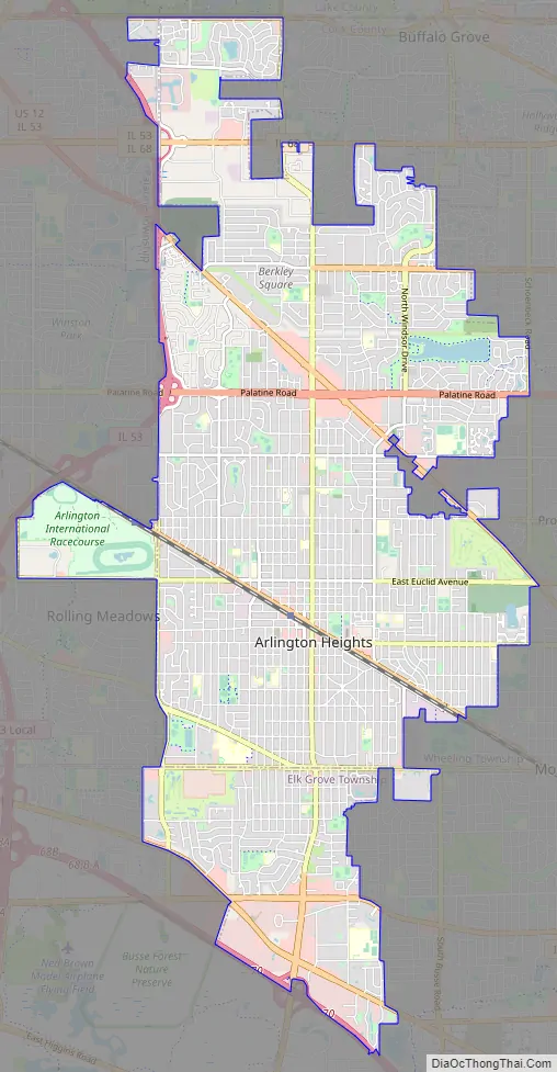
Arlington Heights Road Map
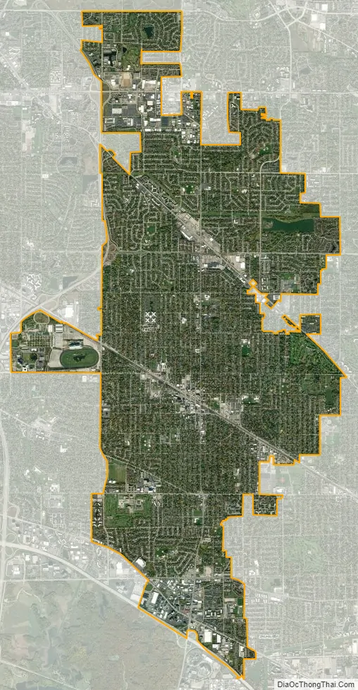
Arlington Heights city Satellite Map
Geography
Arlington Heights is located at 42°05′42″N 87°58′51″W / 42.094976°N 87.980873°W / 42.094976; -87.980873 (42.094976, −87.980873).
According to the 2021 census gazetteer files, Arlington Heights has a total area of 16.64 square miles (43.10 km), of which 16.61 square miles (43.02 km) (or 99.81%) is land and 0.03 square miles (0.08 km) (or 0.19%) is water.
Climate
See also
Map of Illinois State and its subdivision:- Adams
- Alexander
- Bond
- Boone
- Brown
- Bureau
- Calhoun
- Carroll
- Cass
- Champaign
- Christian
- Clark
- Clay
- Clinton
- Coles
- Cook
- Crawford
- Cumberland
- De Kalb
- De Witt
- Douglas
- Dupage
- Edgar
- Edwards
- Effingham
- Fayette
- Ford
- Franklin
- Fulton
- Gallatin
- Greene
- Grundy
- Hamilton
- Hancock
- Hardin
- Henderson
- Henry
- Iroquois
- Jackson
- Jasper
- Jefferson
- Jersey
- Jo Daviess
- Johnson
- Kane
- Kankakee
- Kendall
- Knox
- La Salle
- Lake
- Lake Michigan
- Lawrence
- Lee
- Livingston
- Logan
- Macon
- Macoupin
- Madison
- Marion
- Marshall
- Mason
- Massac
- McDonough
- McHenry
- McLean
- Menard
- Mercer
- Monroe
- Montgomery
- Morgan
- Moultrie
- Ogle
- Peoria
- Perry
- Piatt
- Pike
- Pope
- Pulaski
- Putnam
- Randolph
- Richland
- Rock Island
- Saint Clair
- Saline
- Sangamon
- Schuyler
- Scott
- Shelby
- Stark
- Stephenson
- Tazewell
- Union
- Vermilion
- Wabash
- Warren
- Washington
- Wayne
- White
- Whiteside
- Will
- Williamson
- Winnebago
- Woodford
- Alabama
- Alaska
- Arizona
- Arkansas
- California
- Colorado
- Connecticut
- Delaware
- District of Columbia
- Florida
- Georgia
- Hawaii
- Idaho
- Illinois
- Indiana
- Iowa
- Kansas
- Kentucky
- Louisiana
- Maine
- Maryland
- Massachusetts
- Michigan
- Minnesota
- Mississippi
- Missouri
- Montana
- Nebraska
- Nevada
- New Hampshire
- New Jersey
- New Mexico
- New York
- North Carolina
- North Dakota
- Ohio
- Oklahoma
- Oregon
- Pennsylvania
- Rhode Island
- South Carolina
- South Dakota
- Tennessee
- Texas
- Utah
- Vermont
- Virginia
- Washington
- West Virginia
- Wisconsin
- Wyoming


