Phoenix is a village in Cook County, Illinois, United States. The population was 1,708 at the 2020 census. It is located approximately 19 miles (31 km) south of the Chicago Loop in the Chicago area.
| Name: | Phoenix village |
|---|---|
| LSAD Code: | 47 |
| LSAD Description: | village (suffix) |
| State: | Illinois |
| County: | Cook County |
| Total Area: | 0.46 sq mi (1.20 km²) |
| Land Area: | 0.46 sq mi (1.20 km²) |
| Water Area: | 0.00 sq mi (0.00 km²) |
| Total Population: | 1,708 |
| Population Density: | 3,681.03/sq mi (1,422.38/km²) |
| Area code: | 708 |
| FIPS code: | 1759572 |
| Website: | www.villageofphoenix.org |
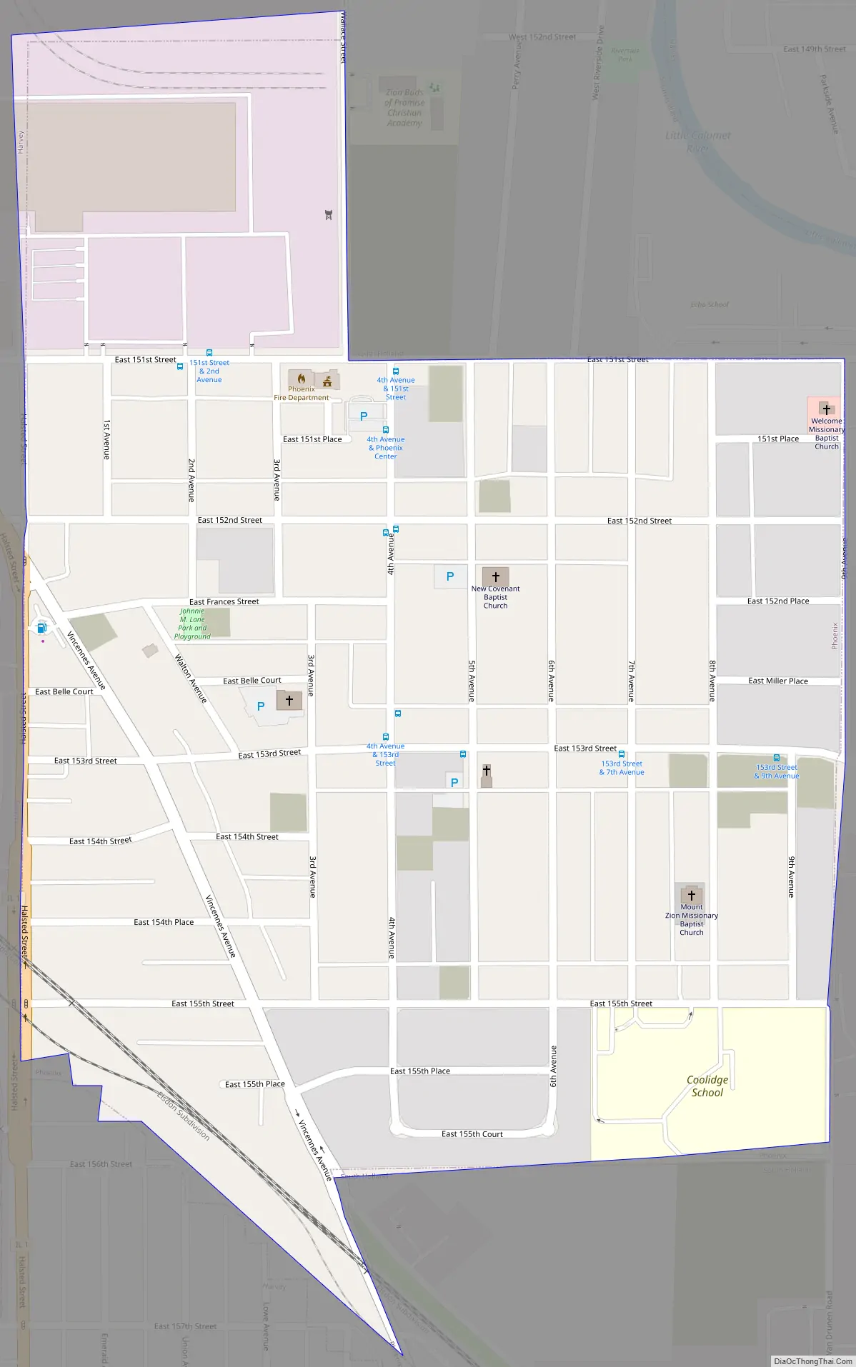
Online Interactive Map
Click on ![]() to view map in "full screen" mode.
to view map in "full screen" mode.
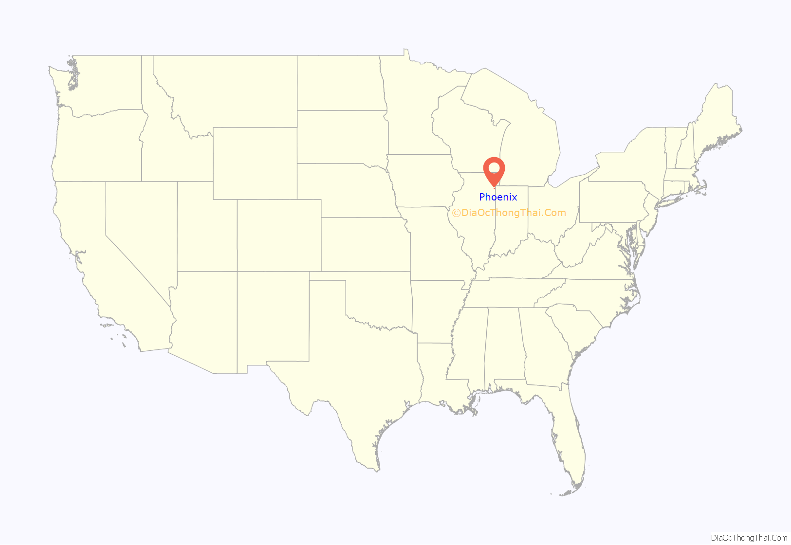
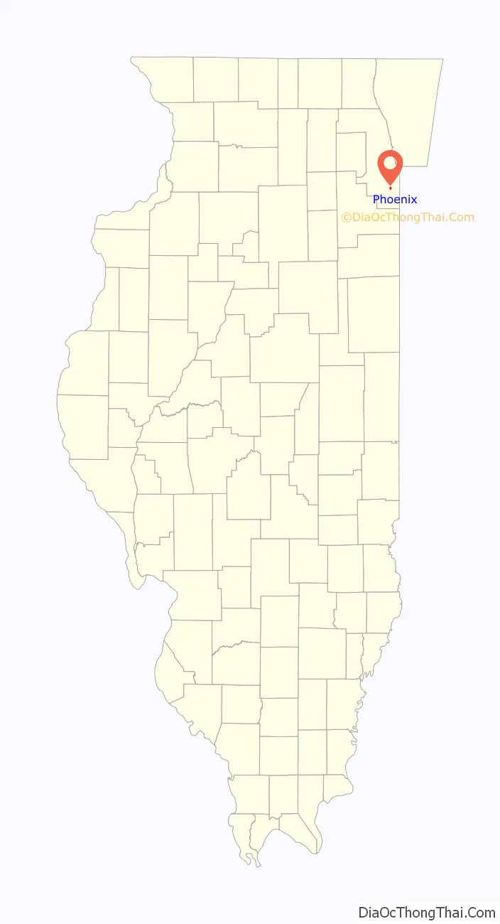
Phoenix location map. Where is Phoenix village?
History
The development of Phoenix is closely tied to its larger neighbor, Harvey. Harvey was established as an industrial city with no saloons. Many of its early factories were located between the Illinois Central Railroad and Harvey’s eastern boundary at Halsted Street. One local businessman, William McLatchy, owned a large tract of land in an unincorporated area outside of Harvey. Soon, five saloons had opened in the area and a small housing subdivision known as Phenix Park was constructed during the 1890s. City leaders in Harvey, seeing businesses just outside their boundaries selling alcohol to local workers, sought to annex Phenix Park and render it “dry” or free of alcohol-related establishments. The residents of Phenix Park wanted to retain local control of their affairs as an independent village. On August 29, 1900, an election was held to determine the future status of the area. A total of 56 votes were cast with 38 (67.9%) voting in favor of incorporation and 18 (32.1%) against. Despite legal challenges from Harvey, the result was upheld.
After incorporation, the name Phenix Park was changed to Phoenix. By 1910, the village had a population of 500, with most residents being of either Dutch or Polish ancestry. The first African Americans moved to Phoenix in 1915. Most came from Chicago and the South. Industry in Harvey and the railroads provided a strong employment base for Phoenix residents. The African American population steadily increased during the 1920s. By 1930, the village was home to 3,033 people. The demographic makeup of the community was 84.2% White, 15.1% Black, and 0.7% other. Growth continued through the 1940s and 1950s. New housing was constructed to accommodate this growth. The population in 1960 was 4,203. At this time, Phoenix had a diverse ethnic composition but the community was racially segregated. African Americans, comprising 65.3% of the population, lived in the northern portion of the village while Whites, forming 34.7% of the population, lived in the southern portion of Phoenix. In 1960, the municipal administration of Phoenix voted to de-annex the predominantly White portion of the village into Harvey. The exchange occurred in 1962 and with it, Phoenix lost one-third of its population as well as 60% of its tax base.
By 1990, the population was 2,217.
On October 16, 1979, Phoenix Mayor William Hawkins was shot and fatally wounded in an ambush outside of his home. He died two days later. Bobby Joe Anderson, a city policeman, was indicted 13 years later for the crime and was convicted of first degree murder in the killing of Hawkins.
Phoenix Road Map
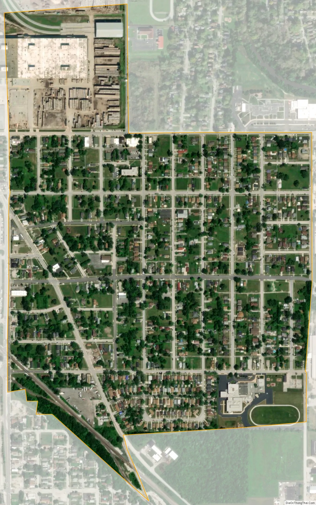
Phoenix city Satellite Map
Geography
Phoenix is located at 41°36′44″N 87°37′50″W / 41.61222°N 87.63056°W / 41.61222; -87.63056 (41.612333, -87.630545) in southern Cook County. The village is nestled between Harvey and South Holland.
According to the 2010 census, Phoenix has a total area of 0.45 square miles (1.17 km), all land.
Surrounding areas
See also
Map of Illinois State and its subdivision:- Adams
- Alexander
- Bond
- Boone
- Brown
- Bureau
- Calhoun
- Carroll
- Cass
- Champaign
- Christian
- Clark
- Clay
- Clinton
- Coles
- Cook
- Crawford
- Cumberland
- De Kalb
- De Witt
- Douglas
- Dupage
- Edgar
- Edwards
- Effingham
- Fayette
- Ford
- Franklin
- Fulton
- Gallatin
- Greene
- Grundy
- Hamilton
- Hancock
- Hardin
- Henderson
- Henry
- Iroquois
- Jackson
- Jasper
- Jefferson
- Jersey
- Jo Daviess
- Johnson
- Kane
- Kankakee
- Kendall
- Knox
- La Salle
- Lake
- Lake Michigan
- Lawrence
- Lee
- Livingston
- Logan
- Macon
- Macoupin
- Madison
- Marion
- Marshall
- Mason
- Massac
- McDonough
- McHenry
- McLean
- Menard
- Mercer
- Monroe
- Montgomery
- Morgan
- Moultrie
- Ogle
- Peoria
- Perry
- Piatt
- Pike
- Pope
- Pulaski
- Putnam
- Randolph
- Richland
- Rock Island
- Saint Clair
- Saline
- Sangamon
- Schuyler
- Scott
- Shelby
- Stark
- Stephenson
- Tazewell
- Union
- Vermilion
- Wabash
- Warren
- Washington
- Wayne
- White
- Whiteside
- Will
- Williamson
- Winnebago
- Woodford
- Alabama
- Alaska
- Arizona
- Arkansas
- California
- Colorado
- Connecticut
- Delaware
- District of Columbia
- Florida
- Georgia
- Hawaii
- Idaho
- Illinois
- Indiana
- Iowa
- Kansas
- Kentucky
- Louisiana
- Maine
- Maryland
- Massachusetts
- Michigan
- Minnesota
- Mississippi
- Missouri
- Montana
- Nebraska
- Nevada
- New Hampshire
- New Jersey
- New Mexico
- New York
- North Carolina
- North Dakota
- Ohio
- Oklahoma
- Oregon
- Pennsylvania
- Rhode Island
- South Carolina
- South Dakota
- Tennessee
- Texas
- Utah
- Vermont
- Virginia
- Washington
- West Virginia
- Wisconsin
- Wyoming


