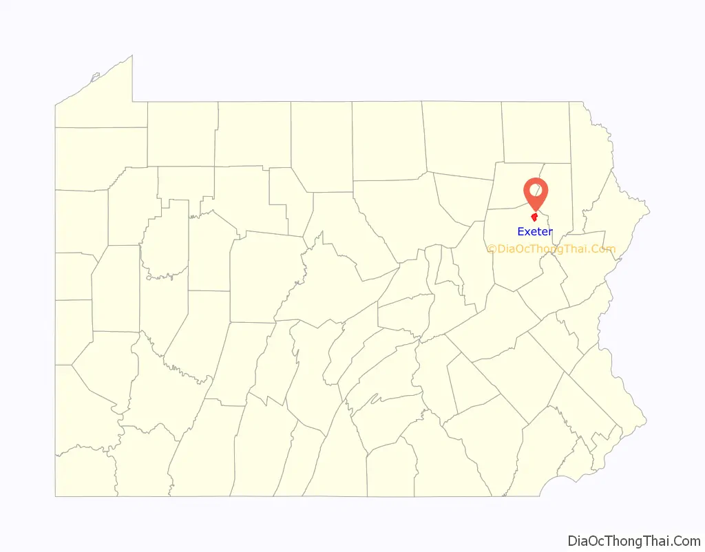
Exeter is a borough in the Greater Pittston-Wilkes-Barre area of Luzerne County, Pennsylvania, United States, about 10 miles (16 km) west of Scranton and a few miles north of Wilkes-Barre. It is located on the western bank of the Susquehanna River and has a total area of 5.0 square miles (12.9 km). As of 2020, Exeter had a population of 5,513.
| Name: | Exeter borough |
|---|---|
| LSAD Code: | 21 |
| LSAD Description: | borough (suffix) |
| State: | Pennsylvania |
| County: | Luzerne County |
| Incorporated: | 1884 |
| Total Area: | 4.92 sq mi (12.75 km²) |
| Land Area: | 4.62 sq mi (11.96 km²) |
| Water Area: | 0.31 sq mi (0.80 km²) |
| Total Population: | 5,514 |
| Population Density: | 1,194.54/sq mi (461.19/km²) |
| ZIP code: | 18643 |
| Area code: | 570 |
| FIPS code: | 4224392 |
Online Interactive Map
Click on ![]() to view map in "full screen" mode.
to view map in "full screen" mode.
Exeter location map. Where is Exeter borough?

History
The name Exeter derives from the ancient city of Exeter in Devon, England. Numerous other places in Canada and the United States have also been given the same name.
In 1769, settlers from Connecticut began making their homes in the Wyoming Valley of Northeastern Pennsylvania but came into conflict with settlers from Pennsylvania during the Pennamite–Yankee Wars.
In early July 1778, during the Revolutionary War, a large-scale raid by Butler’s Rangers and their Iroquois allies entered the valley. Fort Wintermoot (in present-day Exeter) and Fort Jenkins (in present-day West Pittston) quickly surrendered and were later burned to the ground. On July 3, 1778, about 300 Patriot militia and Continentals died at the Battle of Wyoming, also known as the Wyoming massacre, which took place in present day Exeter and Wyoming.
Exeter was founded a fertile agricultural area—once the heartland of the Susquehannock people. Much lumbering and coal-mining was carried out in the area in the 19th and 20th centuries. In the 1830s, the region entered a boom period and began shipping coal by the Pennsylvania Canal, and by the 1840s down the Lehigh Canal to Allentown, Pennsylvania, Philadelphia, Trenton, Wilmington, New York City, and other East Coast cities and ports. This was done by the connecting engineering works of the Lehigh Coal & Navigation Company. These works included the upper Lehigh Canal, the Ashley Planes, the early Lehigh and Susquehanna Railroad (L&S), and other railroads in the area.
After severe flooding ripped up the upper Lehigh Canal in the 1860s, the L&S was extended to the Delaware along the lower canal, keeping the markets of the big cities connected to the still growing Wyoming Valley collieries and breakers. A second rail line was pushed up the Lehigh Gorge (the Lehigh Valley Railroad), which enabled the resurgence of coal exportation to the East Coast cities; it also connected the region to the Erie Railroad and Buffalo, New York.
Exeter was incorporated as a borough in 1884. By 1900, the population consisted of 1,948 citizens. The town lost usable lands in the 1959 Knox Mine Disaster, when the river broke through and flooded the local mines. This essentially shut down the coal mining industry in and around Exeter. Subsequently, despite the local loss of industry, the fact that the population was 5,652 at the 2010 census indicates that the former farmlands have been attractive to building developers.
Exeter Road Map

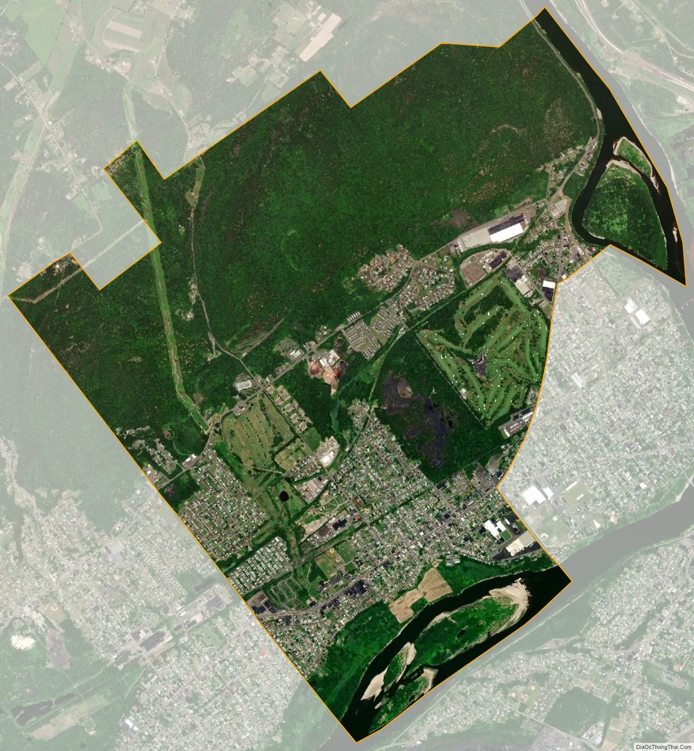
Exeter city Satellite Map
Geography
Exeter is located along the western bank of the Susquehanna River. U.S. Route 11 runs through the southern section of the town, connecting the boroughs of West Pittston and Wyoming. The majority of its streets are arrayed around this highway. PA 92 runs through the eastern portion of the borough, connecting West Pittston and Exeter Township. Fox Hill Country Club is located in central Exeter. The borough surrounds West Pittston from the north, south, and west. Scovell Island and Wintermoot Island are located within Exeter’s borders (on the Susquehanna River). Most of the northern borough consists of hills and forests.
According to the United States Census Bureau, the borough has a total area of 5.0 square miles (12.9 km), of which 4.7 square miles (12.1 km) is land and 0.31 square miles (0.8 km), or 6.52%, is water. Its zip code is 18643. Exeter Borough resides within the Wyoming Area School District. Wyoming Area Catholic School is a parochial school within the borough.
See also
Map of Pennsylvania State and its subdivision:- Adams
- Allegheny
- Armstrong
- Beaver
- Bedford
- Berks
- Blair
- Bradford
- Bucks
- Butler
- Cambria
- Cameron
- Carbon
- Centre
- Chester
- Clarion
- Clearfield
- Clinton
- Columbia
- Crawford
- Cumberland
- Dauphin
- Delaware
- Elk
- Erie
- Fayette
- Forest
- Franklin
- Fulton
- Greene
- Huntingdon
- Indiana
- Jefferson
- Juniata
- Lackawanna
- Lancaster
- Lawrence
- Lebanon
- Lehigh
- Luzerne
- Lycoming
- Mc Kean
- Mercer
- Mifflin
- Monroe
- Montgomery
- Montour
- Northampton
- Northumberland
- Perry
- Philadelphia
- Pike
- Potter
- Schuylkill
- Snyder
- Somerset
- Sullivan
- Susquehanna
- Tioga
- Union
- Venango
- Warren
- Washington
- Wayne
- Westmoreland
- Wyoming
- York
- Alabama
- Alaska
- Arizona
- Arkansas
- California
- Colorado
- Connecticut
- Delaware
- District of Columbia
- Florida
- Georgia
- Hawaii
- Idaho
- Illinois
- Indiana
- Iowa
- Kansas
- Kentucky
- Louisiana
- Maine
- Maryland
- Massachusetts
- Michigan
- Minnesota
- Mississippi
- Missouri
- Montana
- Nebraska
- Nevada
- New Hampshire
- New Jersey
- New Mexico
- New York
- North Carolina
- North Dakota
- Ohio
- Oklahoma
- Oregon
- Pennsylvania
- Rhode Island
- South Carolina
- South Dakota
- Tennessee
- Texas
- Utah
- Vermont
- Virginia
- Washington
- West Virginia
- Wisconsin
- Wyoming


