Pottsville is the county seat of Schuylkill County, Pennsylvania, United States. The population was 13,346 at the 2020 census, and is the principal city of the Pottsville, PA Micropolitan Statistical Area. The city lies along the west bank of the Schuylkill River, 52 miles (84 km) south of Wilkes-Barre. It is located in Pennsylvania’s Coal Region.
Pottsville is located 47.4 miles (76.3 km) west of Allentown, 96.6 miles (155.5 km) northwest of Philadelphia, and 135 miles (217 km) west of New York City.
| Name: | Pottsville city |
|---|---|
| LSAD Code: | 25 |
| LSAD Description: | city (suffix) |
| State: | Pennsylvania |
| County: | Schuylkill County |
| Elevation: | 659 ft (200.9 m) |
| Total Area: | 4.17 sq mi (10.79 km²) |
| Land Area: | 4.17 sq mi (10.79 km²) |
| Water Area: | 0.00 sq mi (0.00 km²) |
| Total Population: | 13,346 |
| Population Density: | 3,203.55/sq mi (1,237.01/km²) |
| ZIP code: | 17901 |
| Area code: | 570 and 272 |
| FIPS code: | 4262432 |
| Website: | www.city.pottsville.pa.us |
Online Interactive Map
Click on ![]() to view map in "full screen" mode.
to view map in "full screen" mode.
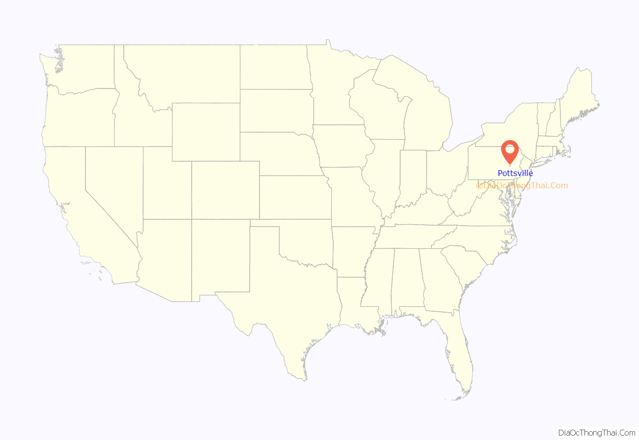
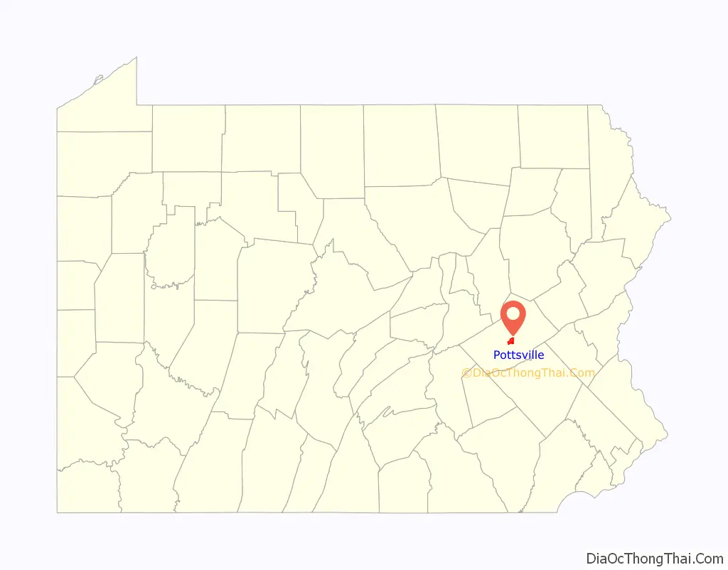
Pottsville location map. Where is Pottsville city?
History
Early settlement
King Charles II granted the land that would eventually become Pottsville to William Penn. This grant comprised all lands west and south of the Delaware River and the Schuylkill; the site of Pottsville was originally in Chester County. When the legislative Council, on May 10, 1729, enacted the law erecting Lancaster County, which included all the lands of the Province lying westward of a straight line drawn northeasterly from the headwaters of Octoraro Creek (near the southern borders) marked with blazed trees, to the Schuylkill River, then this placed Pottsville in Lancaster County. By enactment of the same Council, approved on March 11, 1752, Berks County was erected; this placed Pottsville within the limits of that county.
Pottsville’s anthracite coal history began in 1790 when a coal seam was discovered by hunter Necho Allen. Legend has it that Allen fell asleep at the base of the Broad Mountain and woke to the sight of a large fire; his campfire had ignited an outcropping of coal. By 1795 an anthracite-fired finery forge was established on the Schuylkill River.
19th century
In 1806, John Pott, the founder of Pottsville, purchased the forge. By an act of Assembly of the Commonwealth approved March 1, 1811, the County of Schuylkill was erected out of portions of Berks and Northampton; this placed the site of Pottsville in Schuylkill County. The town was formally laid out in 1816 by a local surveyor, Henry Donnell. Pottsville was established as a village in Norwegian Township in 1819 and incorporated as a borough on February 19, 1828.
In 1829, D.G. Yuengling & Son established what is now the oldest brewery in the United States. In 1851 Pottsville became the county seat, the original county seat being Orwigsburg.
The Philadelphia and Reading Coal and Iron Company, which has its roots in the Philadelphia and Reading Railway Company, the remnants of which were acquired in the late 20th century by the Reading Anthracite Company, acquired extensive coal lands and would become one of the most notable of the coal companies operating in Pennsylvania until the demise of the anthracite industry after World War II.
Because of its location along the Schuylkill River, Pottsville developed a small textile industry. Out of this industry grew the Phillips Van Heusen company which was founded in 1881. Moses Phillips and his wife Endel began sewing shirts by hand and selling them from pushcarts to the local coal miners. Van Heusen and other textile companies left the region starting in the late 1970s, mainly as a result of foreign competition. Another element of the textile industry was the Tilt Silk Mill on Twelfth Street, which produced silk from silk worms imported from China which fed on mulberry trees in the building’s solarium. The silk business eventually was eclipsed by the development of nylon stockings. The building still stands and is presently the headquarters of a storage and vehicle rental business.
20th century
During the Prohibition period in the United States, under the 18th Amendment, Yuengling all but stopped making beer and moved to production of “near beer”. The three brews produced in this time were the Yuengling Special (the most popular brand), Yuengling Por-Tor (a version of their “celebrated Pottsville Porter”), and finally, the Yuengling Juvo, which was a cereal beverage. They were allowed a limited production of porter on the grounds that it had medicinal qualities. Then-owner Frank Yuengling also opened the Yuengling Dairy, which produced ice cream and other dairy products for the local area. These ventures helped to keep the company afloat during that period.
When the 18th Amendment was repealed, Yuengling stopped production of “near beer” and resumed making alcoholic beverages. The brewery famously sent a truckload of its Winner Beer to the White House in 1933 as thanks to President Franklin D. Roosevelt for the repeal of Prohibition. Yuengling still continues its family-owned business today and is the second largest American-owned brewery. The Yuengling Dairy was operated by a different branch of the family from the Brewery. Business declined and the dairy folded as of 1985. Attempted buyouts by large conglomerate breweries have all been unsuccessful.
Pottsville was chartered as a third-class city on March 22, 1911.
Pottsville was host to a National Football League franchise from 1925 to 1928. The Pottsville Maroons played in Sportsman’s Park (or Minersville Park) in nearby Minersville, now the site of King’s Village shopping plaza. The Maroons posted some of the best records in the NFL during the 1925 and 1926 seasons. The Maroons had a claim to the 1925 NFL championship, but because of a controversial decision by NFL President Joe Carr, the title was instead awarded to the Chicago Cardinals. The Maroons suffered two more losing seasons before relocating to Boston and becoming the Boston Bulldogs. The Bulldogs folded in 1929.
Until the middle of the 20th century, Pottsville was a popular destination for many traveling acts and vaudeville performers. The 1929 film Berth Marks stars the comedy legends Laurel and Hardy as they attempt to reach Pottsville by train for one of their booked performances. Pearl Bailey had once resided in Pottsville during the early part of her entertaining career. Soldiers in training at nearby Fort Indiantown Gap were prohibited from visiting Pottsville during most of World War II due to the large numbers of illicit venues and activities present during the time.
21st century
The city completed a streetscaping project in 2007 on Centre Street. In June 2011, the City of Pottsville became the county’s transportation hub for STS (Schuylkill Transportation System) bus service throughout the county with the $16.1 million Union Station Intermodal Transit Center at 300 South Centre Street. It also accommodates Trailways and Greyhound bus services.
The Pottsville Downtown Historic District, Cloud Home, John O’Hara House, Burd Patterson House, Pottsville Armory, D.G. Yuengling and Son Brewing Complex, and Frank D. Yuengling Mansion are listed on the National Register of Historic Places.
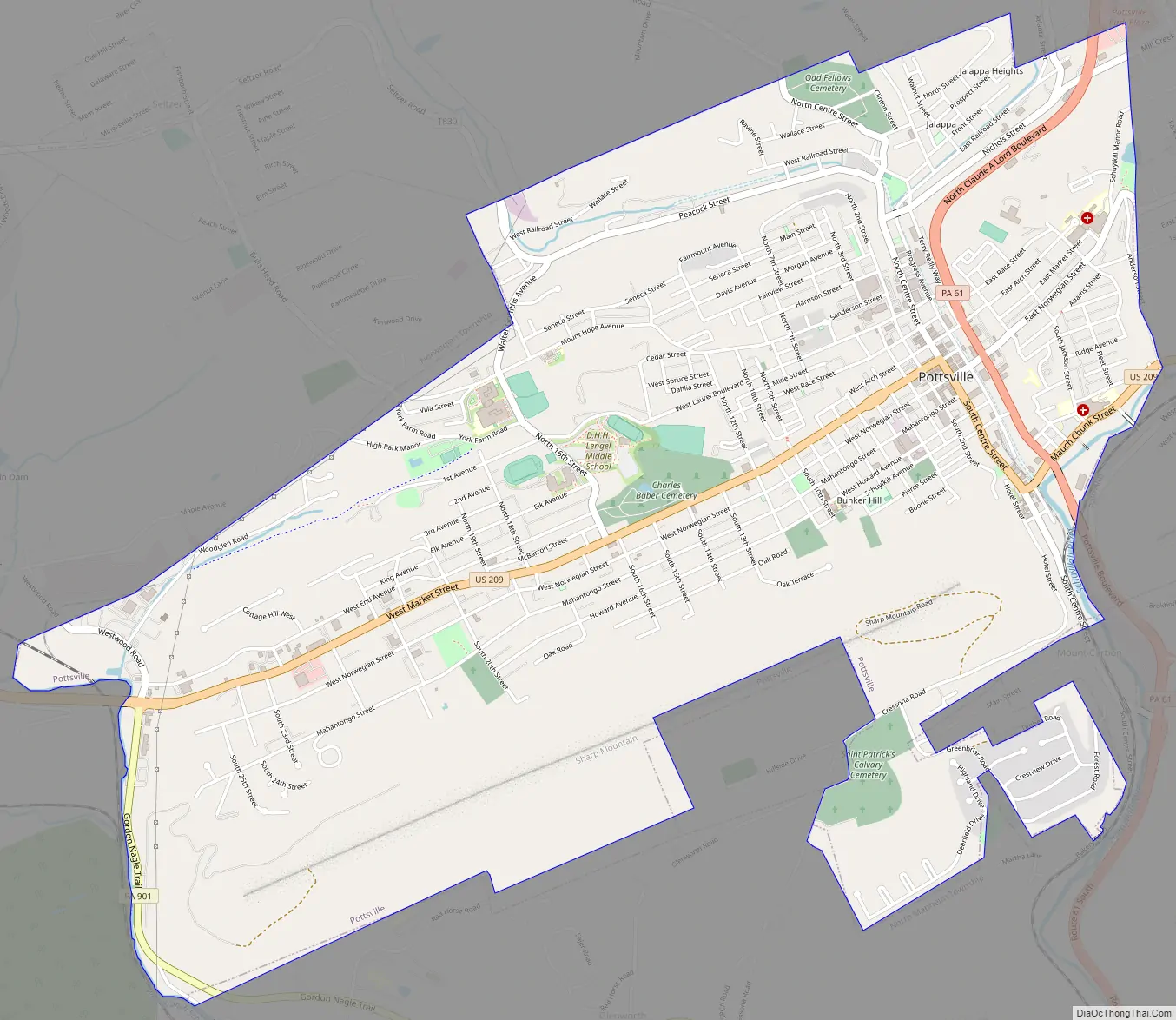
Pottsville Road Map
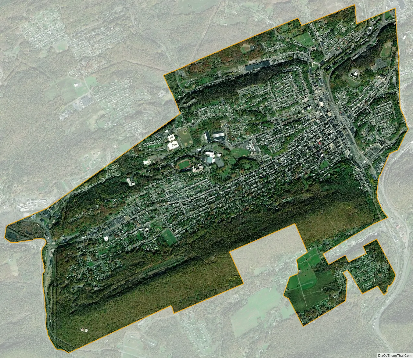
Pottsville city Satellite Map
Geography
Topography
Pottsville is located at 40°41′06″N 76°12′10″W / 40.685058°N 76.202747°W / 40.685058; -76.202747 (40.685058, −76.202747).
According to the United States Census Bureau, the city has a total area of 4.20 square miles (10.9 km), all land. Although there are no lakes within the city there are several water courses which flow through the city. The Schuylkill River flows through the extreme southern part of the city near Mount Carbon. The West Branch of the Schuylkill River makes up most of the western border of the city. Within the city itself, the West Branch of Norwegian Creek flows through the Fishbach section of the city and the East Branch of Norwegian Creek flows through the Jalappa section of the city. Joining together near Progress Avenue and Terry Reiley Way they form Norwegian Creek, which flows underground through the heart of the city. The creek empties into the Schuylkill River at Mauch Chunk Street.
Like ancient Rome, Pottsville sits on seven hills: Lawton’s Hill, Greenwood Hill, Bunker Hill (Sharp Mountain), Guinea Hill, Forest Hills, Cottage Hill, and Mount Hope.
The Pottsville Formation is named after the town; it is a geologic complex including coal, sandstone, and coarse conglomerate that runs along the Appalachian Mountains from Alabama to New York. Its type section is on a cut for the Pennsylvania Railroad through Sharp Mountain south of the city.
Climate
Pottsville experiences a humid subtropical climate (Cfa) according to the Köppen climate classification system if the 26.6 °F (−3.0 °C) isotherm is used, or a humid continental climate (Dfa) if the 32 °F (0 °C) isotherm is used. The record high was 104 °F (40 °C) in 2011, and the record low was −19 °F (−28 °C) in 1994. Average monthly temperatures range from 27.3 °F in January to 72.3 °F in July. [2] The hardiness zone is 6b bordering on 6a and the average annual absolute minimum temperature downtown is -4.6 °F. [3] Archived July 4, 2019, at the Wayback Machine
See also
Map of Pennsylvania State and its subdivision:- Adams
- Allegheny
- Armstrong
- Beaver
- Bedford
- Berks
- Blair
- Bradford
- Bucks
- Butler
- Cambria
- Cameron
- Carbon
- Centre
- Chester
- Clarion
- Clearfield
- Clinton
- Columbia
- Crawford
- Cumberland
- Dauphin
- Delaware
- Elk
- Erie
- Fayette
- Forest
- Franklin
- Fulton
- Greene
- Huntingdon
- Indiana
- Jefferson
- Juniata
- Lackawanna
- Lancaster
- Lawrence
- Lebanon
- Lehigh
- Luzerne
- Lycoming
- Mc Kean
- Mercer
- Mifflin
- Monroe
- Montgomery
- Montour
- Northampton
- Northumberland
- Perry
- Philadelphia
- Pike
- Potter
- Schuylkill
- Snyder
- Somerset
- Sullivan
- Susquehanna
- Tioga
- Union
- Venango
- Warren
- Washington
- Wayne
- Westmoreland
- Wyoming
- York
- Alabama
- Alaska
- Arizona
- Arkansas
- California
- Colorado
- Connecticut
- Delaware
- District of Columbia
- Florida
- Georgia
- Hawaii
- Idaho
- Illinois
- Indiana
- Iowa
- Kansas
- Kentucky
- Louisiana
- Maine
- Maryland
- Massachusetts
- Michigan
- Minnesota
- Mississippi
- Missouri
- Montana
- Nebraska
- Nevada
- New Hampshire
- New Jersey
- New Mexico
- New York
- North Carolina
- North Dakota
- Ohio
- Oklahoma
- Oregon
- Pennsylvania
- Rhode Island
- South Carolina
- South Dakota
- Tennessee
- Texas
- Utah
- Vermont
- Virginia
- Washington
- West Virginia
- Wisconsin
- Wyoming


