Deerfield is a north shore suburb of Chicago in Lake County, Illinois, United States, with a small portion extending into Cook County, Illinois. The population was 19,196 at the 2020 census. Deerfield is home to the headquarters of Walgreens Boots Alliance, Baxter Healthcare, and Fortune Brands Home & Security. Deerfield is often listed among some of the wealthiest and highest earning places in Illinois and the Midwest. The per capita income of the village is $68,101 and the median household income is $143,729.
| Name: | Deerfield village |
|---|---|
| LSAD Code: | 47 |
| LSAD Description: | village (suffix) |
| State: | Illinois |
| County: | Cook County, Lake County |
| Founded: | 1903 |
| Total Area: | 5.55 sq mi (14.38 km²) |
| Land Area: | 5.53 sq mi (14.32 km²) |
| Water Area: | 0.02 sq mi (0.06 km²) |
| Total Population: | 19,196 |
| Population Density: | 3,471.25/sq mi (1,340.21/km²) |
| ZIP code: | 60015 |
| FIPS code: | 1718992 |
Online Interactive Map
Click on ![]() to view map in "full screen" mode.
to view map in "full screen" mode.
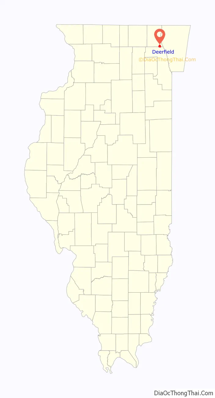
Deerfield location map. Where is Deerfield village?
History
Beginnings
Originally populated by the Bodéwadmiakiwen (Potawatomi), Myaamia (Miami), Kiikaapoi (Kickapoo), and Peoria Native Americans, the area was settled by Horace Lamb and Jacob B. Cadwell in 1835 and named Cadwell’s Corner. A shopping center located on the site of Cadwell’s farm at Waukegan Road and Lake Cook Road still bears that name. The area grew because of the navigable rivers in the area, notably the Des Plaines River and the Chicago River. By 1840, the town’s name was changed to “Leclair”. Within a decade, settler John Millen proposed a further name change to “Deerfield” in honor of his hometown, Deerfield, Massachusetts and the large number of deer living in the area. At the time, the alternate name for the village on the ballot was “Erin”. “Deerfield” won by a vote of 17–13. The village’s first school, Wilmot School, was founded in 1847. Originally a one-room schoolhouse, Wilmot is now an elementary school which serves 548 students. It is located on land donated by Lyman Wilmot, whose wife, Clarissa, was the village’s first school teacher. The village was incorporated in 1903 with a population in the low 400s.
In the 1850s, the Deerfield home of Lyman Wilmot served as a stop on the Underground Railroad as escaped slaves attempted to get to Canada.
20th century
In a 1917 design by Thomas E. Tallmadge of the American Institute of Architects, Deerfield (and adjacent Highland Park) served as the center for a new proposed capital city of the United States. By that year, all of Deerfield’s original farms had been converted either to residential areas or golf courses.
On May 26, 1944, a US Navy plane crashed in Deerfield on the current site of the Deerfield Public Library, killing Ensign Milton C. Pickens. Following World War II, a portion of Waukegan Road (Route 43) that runs through Deerfield has been designated a Blue Star Memorial Highway.
In 1959, when Deerfield officials learned that a developer building a neighborhood of large new homes planned to make houses available to African Americans, they issued a stop-work order. An intense debate began about racial integration, property values, and the good faith of community officials and builders. For a brief time, Deerfield was spotlighted in the national news as “the Little Rock of the North.” Supporters of integration were denounced and ostracized by angry residents. Eventually, the village passed a referendum to build parks on the property, thus putting an end to the housing development. Two model homes already partially completed were sold to village officials. The remaining land lay dormant for years before it was developed into Mitchell Pool and Park and Jaycee Park. At the time, Deerfield’s black population was 12 people out of a total population of 11,786. This episode in Deerfield’s history is described in But Not Next Door by Harry and David Rosen, both residents of Deerfield. On June 18, 2020, the Deerfield Park District Board voted to remove James Mitchell’s name from the park and later renamed it to Floral Park, which was the name originally intended for the sub-division that would have been built at that location.
Since the early 1980s, Deerfield has seen a large influx of Jews, Asians, and Greeks, giving the community a more diverse cultural and ethnic makeup.
On June 27, 1962, ground was broken by Kitchens of Sara Lee (now Sara Lee Corporation) for construction of the world’s largest bakery. The plant, located on the current site of Coromandel Condominiums on Kates Road, began production in 1964 using state-of-the-art materials handling and production equipment. It was billed as the world’s first industrial plant with a fully automated production control system and was designed by Stanley Winton. President Ronald Reagan visited the plant in 1985. The plant closed in 1990 as Sara Lee consolidated production in Tarboro, North Carolina. By 1991, headquarters employees had moved to downtown Chicago. In 2007, Sara Lee severed its final tie to its former home town with the closure of the Sara Lee Bakery Outlet Store.
In 1982, Deerfield began an experiment with a community farm. Two hundred residents applied for plots on a 3-acre (12,000 m) community garden. The project had such a strong initial success that the village opened additional community farms on vacant land in the village.
As of 1987 Deerfield was mostly made up of single-family houses. As of that year the resale prices of Deerfield houses ranged from $100,000 to $300,000. 43.5% of the town’s land consisted of single-family houses, while 1.1% contained multi-family housing. As of that year little of the remaining land was available for further residential development.
21st century
On December 19, 2005, the village board passed a strict anti-smoking ordinance. The law bans smoking in all public places, including businesses, bars, restaurants, parks, parade routes, public assemblies, and within 25 feet (7.6 m) from any of the above.
In November 2007, BusinessWeek.com listed Deerfield third in a list of the 50 best places to raise children. The rankings were based on five factors: school test scores, cost of living, recreational and cultural activities, number of schools and risk of crime. Deerfield ranked behind Groesbeck, Ohio, and Western Springs, Illinois.
In 2015, a plan to rezone a parcel of land originally zoned for single-family homes, in order to allow the construction of a 48-unit affordable apartment building complex, was proposed. Some Deerfield residents were opposed to the proposition.
In 2018, The Village Board of Trustees unanimously approved a ban on what were described as certain types of assault weapons and high-capacity magazines, amending a 2013 ordinance that regulated the storage of those items. This was done despite an Illinois State Preemption on any further municipal firearms restrictions after 2013, and the fact that amendments to municipal ordinances have to pass said amendments as separate ordinances. Lawsuits were filed challenging the Ordinance and the ban was eventually blocked by Lake County Circuit Court Judge Luis Berrones until the lawsuits could be heard. One of the lawsuits is based on the Illinois state preemption statute regarding local bans enacted after 2013.
Deerfield was Sister Cities with Lüdinghausen, Germany until the commission was dissolved in October 2019 due to inactivity.
Deerfield Historic Village
Located in front of Kipling Elementary School is the Deerfield Historic Village, founded and maintained by the Deerfield Area Historical Society, this outdoor museum consists of five historic buildings and includes the headquarters for the Deerfield Historical Society. Tours are offered during the summer months.
The Historic Village includes the Caspar Ott House, where the Ott family assisted in the passage of slaves in the Underground Railroad, considered to be the oldest building in Lake County, built in 1837. It was restored by Bob Przewlocki. The George Luther House (1847) now includes the Society’s offices and Visitor Center. The Bartle Sacker Farmhouse (1854) is a typical 19th century home. While those buildings are all original (although relocated from their original sites), the carriage house and little red school house are replicas. Each year, all fourth graders in Deerfield School District 109 spend a day learning in the school house.
Deerfield Road Map
Deerfield city Satellite Map
Geography
According to the 2021 census gazetteer files, Deerfield has a total area of 5.55 square miles (14.37 km), of which 5.53 square miles (14.32 km) (or 99.60%) is land and 0.02 square miles (0.05 km) (or 0.40%) is water.
Deerfield is bordered to the north by Bannockburn, to the east by Highland Park, to the south by Northbrook and to the west by Riverwoods.
See also
Map of Illinois State and its subdivision:- Adams
- Alexander
- Bond
- Boone
- Brown
- Bureau
- Calhoun
- Carroll
- Cass
- Champaign
- Christian
- Clark
- Clay
- Clinton
- Coles
- Cook
- Crawford
- Cumberland
- De Kalb
- De Witt
- Douglas
- Dupage
- Edgar
- Edwards
- Effingham
- Fayette
- Ford
- Franklin
- Fulton
- Gallatin
- Greene
- Grundy
- Hamilton
- Hancock
- Hardin
- Henderson
- Henry
- Iroquois
- Jackson
- Jasper
- Jefferson
- Jersey
- Jo Daviess
- Johnson
- Kane
- Kankakee
- Kendall
- Knox
- La Salle
- Lake
- Lake Michigan
- Lawrence
- Lee
- Livingston
- Logan
- Macon
- Macoupin
- Madison
- Marion
- Marshall
- Mason
- Massac
- McDonough
- McHenry
- McLean
- Menard
- Mercer
- Monroe
- Montgomery
- Morgan
- Moultrie
- Ogle
- Peoria
- Perry
- Piatt
- Pike
- Pope
- Pulaski
- Putnam
- Randolph
- Richland
- Rock Island
- Saint Clair
- Saline
- Sangamon
- Schuyler
- Scott
- Shelby
- Stark
- Stephenson
- Tazewell
- Union
- Vermilion
- Wabash
- Warren
- Washington
- Wayne
- White
- Whiteside
- Will
- Williamson
- Winnebago
- Woodford
- Alabama
- Alaska
- Arizona
- Arkansas
- California
- Colorado
- Connecticut
- Delaware
- District of Columbia
- Florida
- Georgia
- Hawaii
- Idaho
- Illinois
- Indiana
- Iowa
- Kansas
- Kentucky
- Louisiana
- Maine
- Maryland
- Massachusetts
- Michigan
- Minnesota
- Mississippi
- Missouri
- Montana
- Nebraska
- Nevada
- New Hampshire
- New Jersey
- New Mexico
- New York
- North Carolina
- North Dakota
- Ohio
- Oklahoma
- Oregon
- Pennsylvania
- Rhode Island
- South Carolina
- South Dakota
- Tennessee
- Texas
- Utah
- Vermont
- Virginia
- Washington
- West Virginia
- Wisconsin
- Wyoming


