Orangeville is a village in Stephenson County, Illinois, United States. The town’s sign lists the population at 800 as of January 2021. The population in 2020 was 738. The population according to the 2010 census was 793, up from 751 in 2000. Using the 2020 population of 738 Orangeville is the 741st largest city in Illinois and the 11,650th largest city in the United States. Orangeville is currently declining at a rate of -0.94% annually and its population has decreased by -6.94% since the 2010 census. The area’s earliest white settlers arrived in the year 1833, and the village was platted in 1851 by John Bower, who is considered the village founder. In 1867 Orangeville was incorporated as a village. The town’s central business district contains several 19th century commercial buildings, many of which were built during the railroad boom of 1888–1914. By the time the Great Depression was ongoing, business in Orangeville had started to decline, with the last bank closing in 1932. In 1956 another bank started operating in the village and is still in town today. Some recent infrastructure jumps have restored some of the village’s old decor.
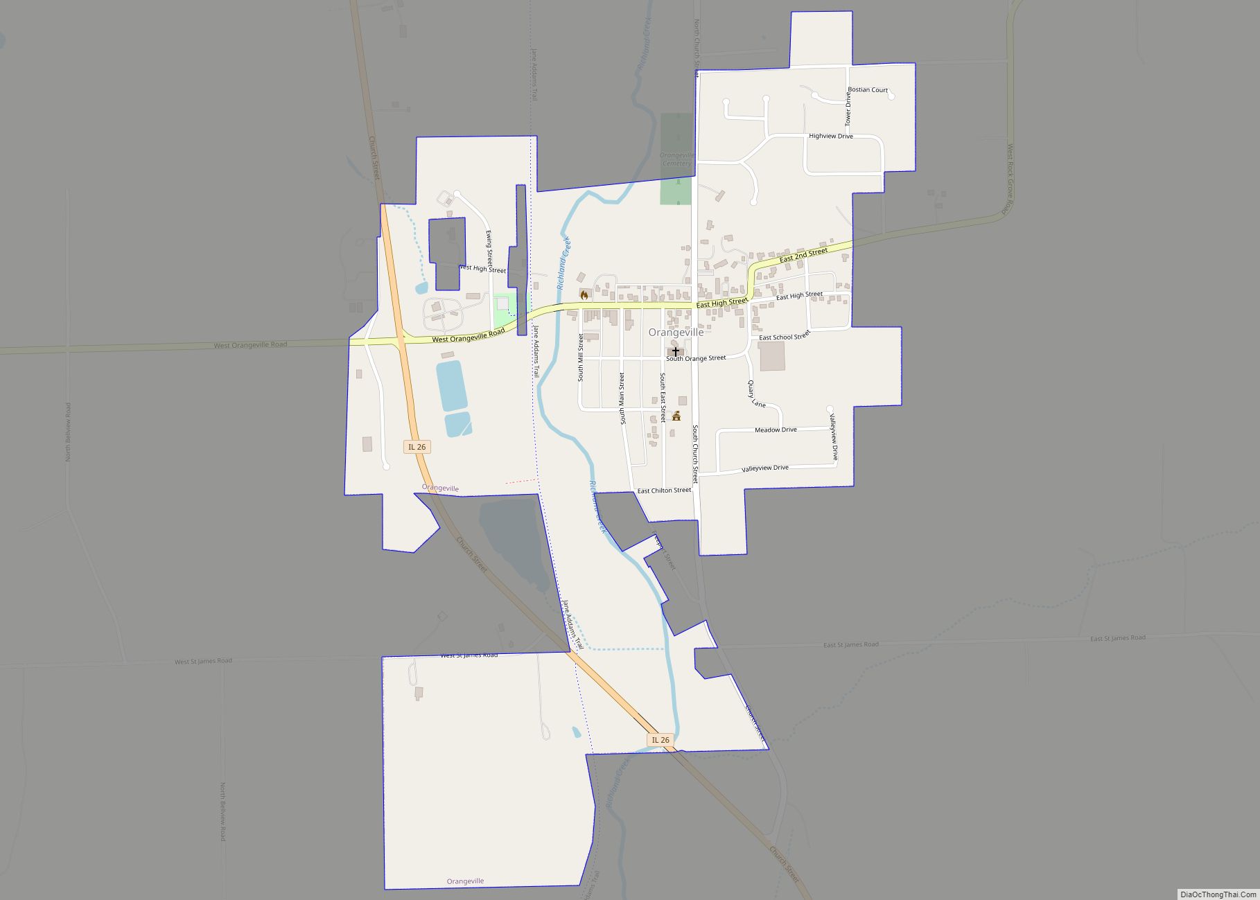
Orangeville is about two miles (3 km) south of the Illinois – Wisconsin border and about 35 miles (56 km) west of Rockford, Illinois. Orangeville is located directly off of Illinois Route 26 between Monroe, Wisconsin and Freeport, Illinois. The town itself is located in farmland surrounded by vale and rises from Richland Creek on its west end, down High Street and into the central business district, where the Central House hotel occupies the highest lot. Public education in Orangeville is the responsibility of Orangeville Community School District #203 which previously operated an elementary school on the south side and a combination junior and senior high school on the east side. In 2019 the district combined the elementary school with the joint high school on the east side to create the Orangeville High School. The previous elementary school was converted to a multi-family complex.
| Name: | Orangeville village |
|---|---|
| LSAD Code: | 47 |
| LSAD Description: | village (suffix) |
| State: | Illinois |
| County: | Stephenson County |
| Founded: | 1851 |
| Elevation: | 820 ft (250 m) |
| Total Area: | 0.68 sq mi (1.75 km²) |
| Land Area: | 0.68 sq mi (1.75 km²) |
| Water Area: | 0.00 sq mi (0.00 km²) |
| Total Population: | 766 |
| Population Density: | 1,133.14/sq mi (437.61/km²) |
| Area code: | 815 |
| FIPS code: | 1756341 |
| Website: | http://villageoforangeville.com/ |
Online Interactive Map
Click on ![]() to view map in "full screen" mode.
to view map in "full screen" mode.
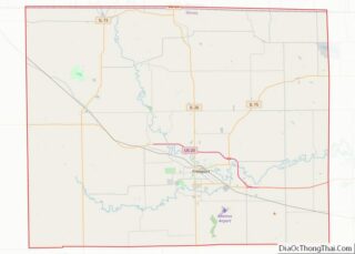
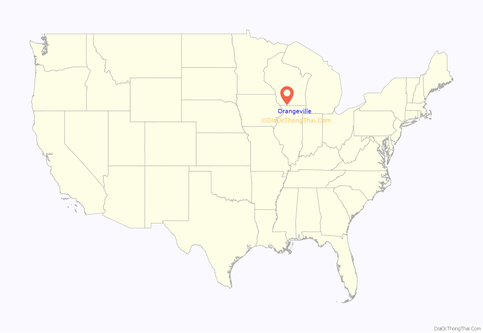
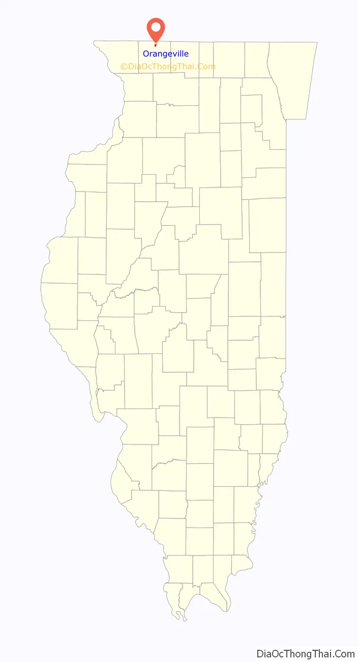
Orangeville location map. Where is Orangeville village?
History
Early history
Before 1837, the area was occupied by Native Americans who utilized it for hunting grounds; the Sioux tribe had a camp near Oneco. Game that populated the Orangeville area included buffalo and deer. John H. Curtis purchased the 80 acres (32 ha) of land, which included the area that would eventually become Orangeville, on January 1, 1838 at the Dixon Land Office. Curtis constructed a dam on Richland Creek, and on the creek’s west bank erected a gristmill and a saw mill. Curtis died in 1843 and both mills stood idle until John Bower arrived in 1846, with his family, after having visited the area the year before. Bower purchased the 80 acres (32 ha) and the mills.
Throughout the 1830s and 1840s farmers from New York and Pennsylvania, known as the Pennsylvania Dutch, arrived to settle the area around present-day Orangeville. Of the first 14 settlers to the area, 13 were Pennsylvania Dutch, the 14th was a German immigrant. A Dr. Thomas Van Valsah led a wagon train from Pennsylvania to Stephenson County in 1837.
The village of Orangeville was founded by John Bower, popularly confused as “Bowers.” Bower came to Stephenson County in 1845 and, on October 16, 1846, bought the land that would be platted as Orangeville from for $950. Bower built the Union House in 1849 on a portion of what became Orangeville in 1851. Though the town was platted by Bower in 1851, it was not incorporated until 1867. A drawing of the plat was done by surveyor Marcus Montelius and indicated that Orangeville has always been known as Orangeville; several publications have asserted that the town began as Bowersville or Bowers Mills and underwent a name change in 1854. It is possible that the incorrect name Bowersville was a misremembered version of “Bower’s mill”. The plat also showed 48 original town lots.
At the outset, Bower brought “wagon loads” of lumber from Galena and Chicago to the settlement, and by 1849 he had reconstructed and improved the gristmill. The mill was completed in 1850 at a cost of $8,000. Charles Moore, who would become the first President of the village when it was incorporated, came to the town, lured by Bower’s efforts, in 1849. George Hamilton built a store and soon farmers began to build houses, by 1850 a stagecoach served the area. In September 1852 construction began on Orangeville’s first church.
By 1854, Orangeville was in competition with the village of Oneco as a growing center of commerce. That year, the federal government decided that population growth in the two villages warranted the establishment of a post office. On an appointed day, residents of both villages lined up on the sides of the street according to which town they supported as the location for the post office. Orangeville won by a narrow margin.
Arrival of the railroad
After its incorporation the village continued to prosper, the downtown district was mostly complete by the 1870s, with all commercial lots purchased and improved. Mel Trotter who established a chain of rescue missions during his lifetime, was born in the village on May 16, 1870 and lived there until he was five years old when his family moved to Polo, Illinois. By 1877, the village population was up to 300 and in 1883 the Orangeville Alert, the first village newspaper, was established. In 1887, the Illinois Central Railroad decided to link Freeport to Madison, Wisconsin. The only incorporated village along that line was Orangeville, the railroad came in 1888 and led to commercial building boom. This building boom directly resulted in 14 new buildings being erected downtown, all brick buildings downtown save the 1906 Wagner Building and the 1899 R.W. Moore Building were a result of the railroad. Between 1888 and 1914, numerous business developed along the corridor of Main and High Streets, those included: restaurants, drug stores, barber shops, banks, watch and clock repair shops, cigar factory, funeral parlor and casket factory, among several others.
Great Depression
In 1928, just before the onset of the Great Depression, Illinois State Highway 74 (later Illinois Route 26) was rerouted through the eastern part of Orangeville, bypassing the downtown business district. Though the downtown district no longer had a major thoroughfare passing through it, many of the business were able to survive, at least initially. By 1928, the decline in the business community of Orangeville was evident; the bypass, coupled with the depression continued to negatively affect the village. In 1932, the People’s State Bank, the last open bank in Orangeville, closed its doors.
Orangeville Road Map
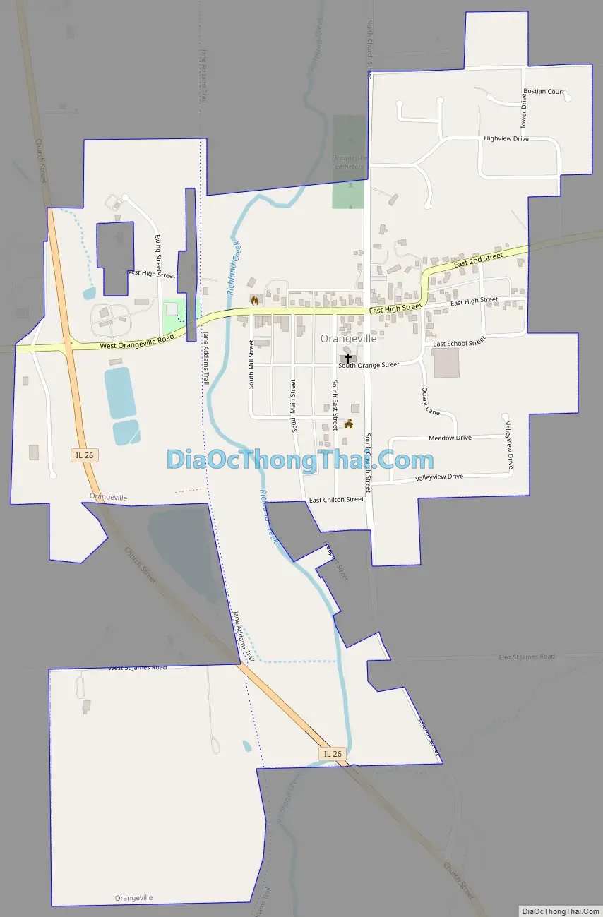
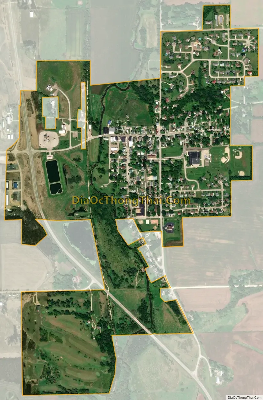
Orangeville city Satellite Map
Geography
Orangeville is located at 42°28′1″N 89°38′46″W / 42.46694°N 89.64611°W / 42.46694; -89.64611 (42.466900, -89.646003). According to the 2010 census, Orangeville has a total area of 0.63 square miles (1.63 km), all land. The village of Orangeville is located in northern Stephenson County, about two miles (3 km) south of the Illinois-Wisconsin border directly off of Illinois Route 26. The village is 11 miles (18 km) south of Monroe, Wisconsin, 12 miles (19 km) north of Freeport, 35 miles (56 km) west of Rockford and 60 miles (97 km) east of Dubuque, Iowa.
The village is located in a vale which is surrounded by farmland. At the western end, and lowest end, of town Richland Creek runs north–south and is paralleled by the old Illinois Central Railroad bed. The railroad bed is now part of the Jane Addams Trail. High Street, which runs through the historic downtown is the primary east–west route through the village and Main Street, which intersects High Street at its highest point, becomes Freeport Road and leads to the city of Freeport.
See also
Map of Illinois State and its subdivision:- Adams
- Alexander
- Bond
- Boone
- Brown
- Bureau
- Calhoun
- Carroll
- Cass
- Champaign
- Christian
- Clark
- Clay
- Clinton
- Coles
- Cook
- Crawford
- Cumberland
- De Kalb
- De Witt
- Douglas
- Dupage
- Edgar
- Edwards
- Effingham
- Fayette
- Ford
- Franklin
- Fulton
- Gallatin
- Greene
- Grundy
- Hamilton
- Hancock
- Hardin
- Henderson
- Henry
- Iroquois
- Jackson
- Jasper
- Jefferson
- Jersey
- Jo Daviess
- Johnson
- Kane
- Kankakee
- Kendall
- Knox
- La Salle
- Lake
- Lake Michigan
- Lawrence
- Lee
- Livingston
- Logan
- Macon
- Macoupin
- Madison
- Marion
- Marshall
- Mason
- Massac
- McDonough
- McHenry
- McLean
- Menard
- Mercer
- Monroe
- Montgomery
- Morgan
- Moultrie
- Ogle
- Peoria
- Perry
- Piatt
- Pike
- Pope
- Pulaski
- Putnam
- Randolph
- Richland
- Rock Island
- Saint Clair
- Saline
- Sangamon
- Schuyler
- Scott
- Shelby
- Stark
- Stephenson
- Tazewell
- Union
- Vermilion
- Wabash
- Warren
- Washington
- Wayne
- White
- Whiteside
- Will
- Williamson
- Winnebago
- Woodford
- Alabama
- Alaska
- Arizona
- Arkansas
- California
- Colorado
- Connecticut
- Delaware
- District of Columbia
- Florida
- Georgia
- Hawaii
- Idaho
- Illinois
- Indiana
- Iowa
- Kansas
- Kentucky
- Louisiana
- Maine
- Maryland
- Massachusetts
- Michigan
- Minnesota
- Mississippi
- Missouri
- Montana
- Nebraska
- Nevada
- New Hampshire
- New Jersey
- New Mexico
- New York
- North Carolina
- North Dakota
- Ohio
- Oklahoma
- Oregon
- Pennsylvania
- Rhode Island
- South Carolina
- South Dakota
- Tennessee
- Texas
- Utah
- Vermont
- Virginia
- Washington
- West Virginia
- Wisconsin
- Wyoming