Arrow Rock is a village in Saline County, Missouri, United States, located near the Missouri River. The entire village is part of the National Historic Landmark Arrow Rock Historic District, designated by the Department of the Interior, National Park Service in 1963. It is significant in the history of Westward Expansion, the Santa Fe Trail, and 19th-century artist George Caleb Bingham. The town is well known for the Arrow Rock Lyceum Theatre, hosting over 33,000 patrons every year.
The first state-designated historic site is located here. Restoration of a 19th-century tavern in 1923 marked the beginning of historic preservation in Missouri. Many structures within the village are individually listed on the National Register of Historic Places. Several locations are also certified sites of the Lewis and Clark National Historic Trail and the Santa Fe National Historic Trail.
The village retains much of its 19th-century Boonslick character, and it attracts more than 100,000 visitors per year. Given the importance of heritage tourism to the village’s economy, architectural ordinances implemented in 2004 provide guidance for both new construction and restorations of existing structures.
The town has numerous bed and breakfast establishments, and a modern campground nearby is maintained by the Missouri Division of State Parks. Local government consists of an elected five-member Board of Trustees. The Trustees elect their chair person (mayor).
| Name: | Arrow Rock town |
|---|---|
| LSAD Code: | 43 |
| LSAD Description: | town (suffix) |
| State: | Missouri |
| County: | Saline County |
| Elevation: | 722 ft (220 m) |
| Total Area: | 0.13 sq mi (0.35 km²) |
| Land Area: | 0.13 sq mi (0.35 km²) |
| Water Area: | 0.00 sq mi (0.00 km²) |
| Total Population: | 60 |
| Population Density: | 451.13/sq mi (173.80/km²) |
| ZIP code: | 65320 |
| Area code: | 660 |
| FIPS code: | 2902044 |
| GNISfeature ID: | 2397439 |
| Website: | arrowrock.org |
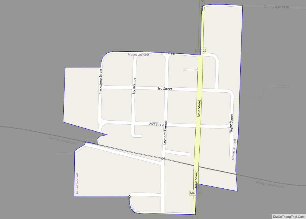
Online Interactive Map
Click on ![]() to view map in "full screen" mode.
to view map in "full screen" mode.
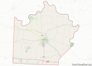
Arrow Rock location map. Where is Arrow Rock town?
History
Arrow Rock was the name of a prominent flint-bearing bluff on the Missouri River. The name first appeared on a French map from 1732 as “Pierre a Fleche” meaning “Rock of Arrows.” Edwin James on the 1819 Yellowstone Expedition wrote, “Arrow Rock is so called from its having been formerly resorted to by neighboring Indians for the stone used to point their arrows.” The two dominant Native American tribes in the area encountered by French traders early in the 18th century were the Missouria and the Osage.
The bluff continued to be a landmark to explorers and travelers for over 150 years. Lewis and Clark passed by on June 9, 1804, and noted “Several small Channels running out of the River below a Bluff [Cliff of rocks called the arrow rock ] & Prairie (Called the Prairie of Arrows)” In 1808, William Clark passed through the area again on his way to construct Fort Osage noting a “Big Arrow Rock” and a “Little Arrow Rock” just upstream from it. He declared the area would “make a handsome spot for a town.”
During the first half of the 19th century, this region of central Missouri was called “Boonslick Country” so named for the Boone’s salt lick about four miles east of Arrow Rock in adjacent Howard County. The term “lick” derived from wildlife licking salt from the ground around the briny springs. Nathan and Daniel Morgan Boone, sons of famed frontiersman Daniel Boone, manufactured salt here from 1805 to 1812, shipping it to St. Louis. Their partners and co-operators, James and Jesse Morrison, continued the salt business until 1833. Salt boiling continued intermittently until the 1860s. The site of this early frontier industry is now managed as Boone’s Lick State Historic Site by the Missouri Division of State Parks.
Euro-American settlers arrived in 1810, establishing small settlements several miles to the north and to the south of the Arrow Rock bluff and in the river bottoms on the opposite side of the Missouri River. During the War of 1812, these settlers built small defensive forts as protection from Ioway, Sac & Fox Indians allied to Great Britain. When Fort Osage closed in 1813, the fort’s factor (trader) George C. Sibley moved his operation to the Arrow Rock bluff during the winter of 1813-1814 to carry on trade with the Osage Indians. This helped maintain their loyalty the United States during the war.
By 1815, a ferry was established at the site of Arrow Rock. Westbound settlers poured into the area, crossing the Missouri River on the Arrow Rock ferry. Santa Fe trading caravans departing from Franklin began crossing at the ferry in 1821. From 1819 to 1833, the ferry was owned by Judge David Todd, the uncle of Mary Todd Lincoln. Judge William B. Napton noted that 1827 was an especially busy year for the ferry as the population of Saline County swelled that year. In 1849 and 1850 the covered wagons of emigrants to California “were hardly ever out of sight at Arrow Rock.” Several Arrow Rock residents continued to be involved in the Santa Fe trade as late as the beginning of the Civil War, 1861.
The town was founded in June 1829 and originally called “Philadelphia.” Some documents refer to it as “New Philadelphia.” However, in 1833 the state legislature changed the name because the locale was better known as ‘Arrow Rock’. Joseph Huston, one of the town commissioners, built a two-story brick building in 1834. Due to Arrow Rock’s location on the Missouri River and along the Santa Fe Trail, travelers undoubtedly asked Huston for overnight accommodations. He began building frame or log additions to the brick building and by 1840 was widely known as a hotel-keeper. The J. Huston Tavern also housed a store and a ballroom used for dances and a meeting hall. As the building passed to other owners, it became known as the Neill House, Scripture House, City Hotel and Old Tavern. The J. Huston Tavern houses the oldest continuously operating restaurant west of the Mississippi and is today operated by the Missouri Division of State Parks in partnership with the Friends of Arrow Rock, Inc.
Settlers in the Arrow Rock area were predominantly migrants from the Upper South of Virginia, Kentucky, and Tennessee. They brought slaves and southern culture with them. The town developed as a thriving river port, exporting tobacco and hemp from plantations in the region. Hemp was the most important cash crop in Saline County. Before the Civil War, hemp was made into ropes and bags for baling cotton. Wheat, corn, beef, pork and mules were also shipped from Arrow Rock to supply the cotton districts of the Mississippi delta. The agricultural production of the Boonslick Country depended on slave labor just as cotton production did in the South. This symbiotic relationship led most residents of Arrow Rock and the Boonslick Country to support the South during the Civil War. Saline County and other Missouri counties with a high population of enslaved African Americans later became identified as “Little Dixie.” According to historian Dr. Christopher Phillips, Arrow Rock represented a unique blending of western frontier idealism and southern traditions.
During the town’s early decades, it was the site of a slave market, and the auction block continued to stand on the river bluff in front of the J. Huston Tavern for many decades after the Emancipation Proclamation and the U.S. victory in the Civil War eradicated human enslavement. Because of the slave market’s prominence, the large bend in the Missouri River below the town was known as “N***** Bend.”
Arrow Rock’s population peaked at 1,000 by 1860. Even as late as 1872, the town was considered one of the busiest river ports between St. Louis and Kansas City, Missouri. During the Civil War there were no major battles in the area, but guerrilla raids and murders disrupted agricultural production and river commerce. Union militia enforced martial law on the town during most of the war. Town government conducted little business in 1861 and 1862 and did not convene at all from 1863 to 1865. The population began to decline after the war and railroads began supplanting steamboat commerce. Arrow Rock failed in its bids to secure a rail line and a bridge across the Missouri River. The rapid post war growth of urban areas such as Kansas City, St. Louis and Chicago began drawing away residents with the promise of better jobs. The town was swept by disastrous fires in 1864, 1872 and 1901. By the turn of the 20th century the population had declined to around 300.
Prior to the Civil War, Arrow Rock’s black residents worked as household or domestic slaves or as laborers at the docks and business warehouses. Many were skilled tradesmen who were rented out by their masters to business contractors. Much of the town’s infrastructure such as the massive stone gutters lining Main Street, were built by enslaved African-Americans. Following emancipation in 1865, Arrow Rock’s African-American population grew as former plantation slaves moved into town. Gradually they were able to purchase their own homes, mostly on the north side of town. By 1880, 51% of the town’s population was African-American. Owing to segregation of the time, they had to develop their own churches, schools and social institutions. The last black resident of the community died in 2009.
Arrow Rock’s connection with the Santa Fe Trail led to national recognition by the Old Trails Society of the Daughters of the American Revolution (DAR) in 1912. As DAR interest in the community grew, they persuaded the Missouri legislature to purchase and preserve the “Old Tavern” (J. Huston Tavern) in 1923. Acreage around the Tavern was purchased as a state park. This was the beginning of publicly funded historic preservation in Missouri and one of the first units of the new Missouri State Park system. The park grew to 169 acres, about a third of which lies within town boundaries. In 1976 the facilities designation was changed from park to historic site to better reflect its cultural mission.
The Friends of Arrow Rock, Inc., formed in 1959 to help preserve historic structures outside the state historic site boundary. They give guided tram tours of town from April though October and work closely with Arrow Rock State Historic in conducting education and interpretive programs about the village.
Arrow Rock Road Map
Arrow Rock city Satellite Map
Geography
According to the United States Census Bureau, the village has a total area of 0.13 square miles (0.34 km), all land.
See also
Map of Missouri State and its subdivision:- Adair
- Andrew
- Atchison
- Audrain
- Barry
- Barton
- Bates
- Benton
- Bollinger
- Boone
- Buchanan
- Butler
- Caldwell
- Callaway
- Camden
- Cape Girardeau
- Carroll
- Carter
- Cass
- Cedar
- Chariton
- Christian
- Clark
- Clay
- Clinton
- Cole
- Cooper
- Crawford
- Dade
- Dallas
- Daviess
- De Kalb
- Dent
- Douglas
- Dunklin
- Franklin
- Gasconade
- Gentry
- Greene
- Grundy
- Harrison
- Henry
- Hickory
- Holt
- Howard
- Howell
- Iron
- Jackson
- Jasper
- Jefferson
- Johnson
- Knox
- Laclede
- Lafayette
- Lawrence
- Lewis
- Lincoln
- Linn
- Livingston
- Macon
- Madison
- Maries
- Marion
- McDonald
- Mercer
- Miller
- Mississippi
- Moniteau
- Monroe
- Montgomery
- Morgan
- New Madrid
- Newton
- Nodaway
- Oregon
- Osage
- Ozark
- Pemiscot
- Perry
- Pettis
- Phelps
- Pike
- Platte
- Polk
- Pulaski
- Putnam
- Ralls
- Randolph
- Ray
- Reynolds
- Ripley
- Saint Charles
- Saint Clair
- Saint Francois
- Saint Louis
- Sainte Genevieve
- Saline
- Schuyler
- Scotland
- Scott
- Shannon
- Shelby
- Stoddard
- Stone
- Sullivan
- Taney
- Texas
- Vernon
- Warren
- Washington
- Wayne
- Webster
- Worth
- Wright
- Alabama
- Alaska
- Arizona
- Arkansas
- California
- Colorado
- Connecticut
- Delaware
- District of Columbia
- Florida
- Georgia
- Hawaii
- Idaho
- Illinois
- Indiana
- Iowa
- Kansas
- Kentucky
- Louisiana
- Maine
- Maryland
- Massachusetts
- Michigan
- Minnesota
- Mississippi
- Missouri
- Montana
- Nebraska
- Nevada
- New Hampshire
- New Jersey
- New Mexico
- New York
- North Carolina
- North Dakota
- Ohio
- Oklahoma
- Oregon
- Pennsylvania
- Rhode Island
- South Carolina
- South Dakota
- Tennessee
- Texas
- Utah
- Vermont
- Virginia
- Washington
- West Virginia
- Wisconsin
- Wyoming