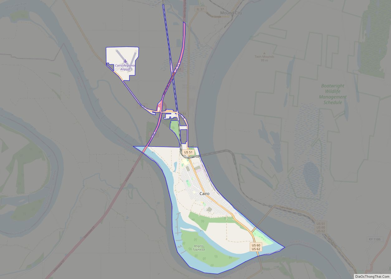
Cairo (/ˈkɛəroʊ/ KAIR-oh) is the southernmost city in Illinois and the county seat of Alexander County.
The city is located at the confluence of the Ohio and Mississippi rivers. Fort Defiance, a Civil War camp, was built here in 1862 by Union General Ulysses S. Grant to control strategic access to the rivers, and launch and supply his successful campaigns south. Cairo has the lowest elevation of any location in Illinois and is the only Illinois city to be surrounded by levees. It is in the area of Southern Illinois known as Little Egypt, for which the city is named after Egypt‘s capital.
Several blocks in the town comprise the Cairo Historic District, listed on the National Register of Historic Places (NRHP). The Old Customs House is also on the NRHP. The city is part of the Cape Girardeau–Jackson, MO–IL Metropolitan Statistical Area. Developed as a river port, Cairo was later bypassed by transportation changes away from the large expanse of low-lying land and water, which surrounds Cairo, and due to industrial restructuring, the population peaked at 15,203 in 1920, while in the 2020 census it was 1,733.
The entire city was evacuated during the 2011 Mississippi River Floods, after the Ohio River rose higher than the 1937 flood levels, with the possibility of 15 feet of water inundating Cairo. The United States Army Corps of Engineers breached levees in the Mississippi flood zone near Cairo in Missouri to prevent flooding in Cairo and other more populous areas further downstream along both the Ohio and Mississippi rivers.
| Name: | Cairo city |
|---|---|
| LSAD Code: | 25 |
| LSAD Description: | city (suffix) |
| State: | Illinois |
| County: | Alexander County |
| Elevation: | 315 ft (96 m) |
| Total Area: | 9.11 sq mi (23.59 km²) |
| Land Area: | 6.99 sq mi (18.10 km²) |
| Water Area: | 2.12 sq mi (5.49 km²) |
| Total Population: | 1,733 |
| Population Density: | 248.03/sq mi (95.77/km²) |
| ZIP code: | 62914 |
| Area code: | 618 |
| FIPS code: | 1710383 |
| GNISfeature ID: | 2393491 |
| Website: | www.cairodevelopment.com |
Online Interactive Map
Click on ![]() to view map in "full screen" mode.
to view map in "full screen" mode.
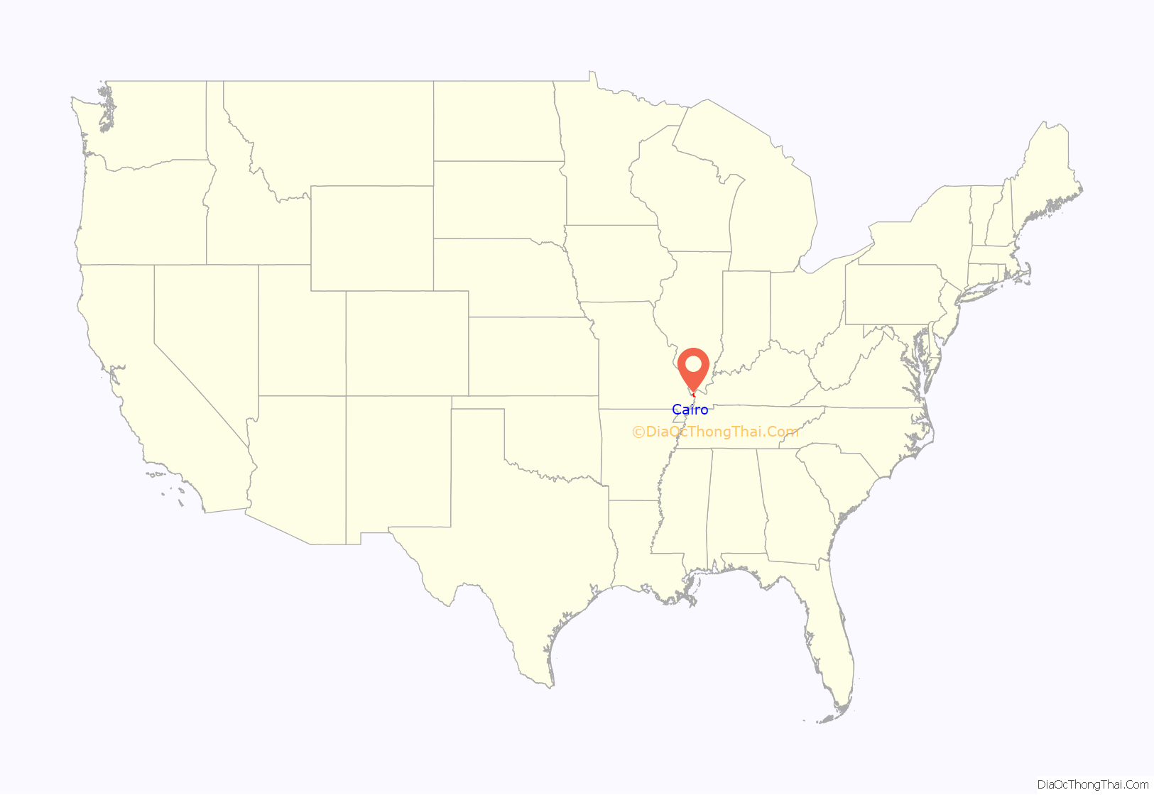
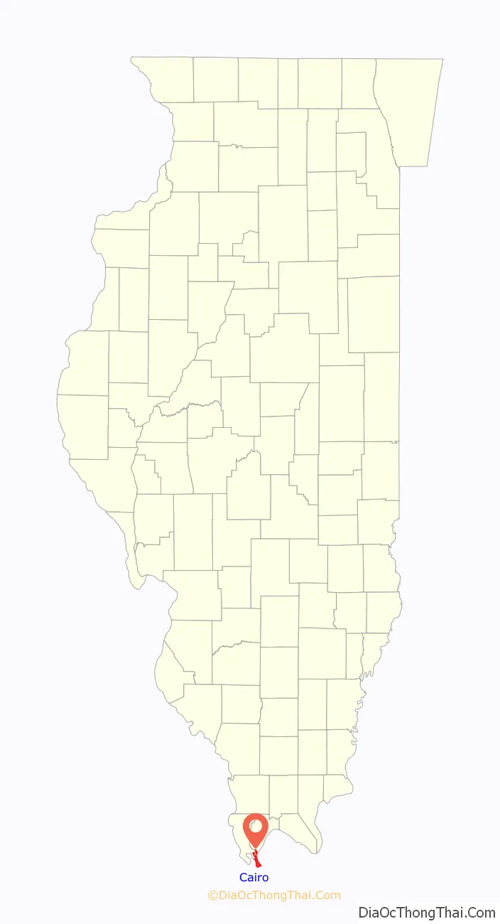
Cairo location map. Where is Cairo city?
History
Beginnings
The first municipal charter for Cairo and for the Bank of Cairo were issued in 1818, but without any settlement and without any depositors. A second and successful effort to establish a town was made by the Cairo City and Canal Company in 1836–37, with a large levee built to encircle the site. However, this effort collapsed in 1840, with few settlers remaining.
Charles Dickens visited Cairo in 1842, and was unimpressed. The city would serve as his prototype for the nightmare City of Eden in his novel Martin Chuzzlewit. In 1846, 10,000 acres in Cairo were purchased by the trustees of the Cairo City Property Trust, a group of investors including writer John Neal who planned to make it the terminus of the projected Illinois Central Railroad, which finally arrived there in 1855.
Cairo had been growing as an important river port for steamboats, which traveled all the way south to New Orleans. The city had been designated as a port of delivery by Act of Congress in 1854.
A new city charter was written in 1857, and Cairo flourished as trade with Chicago to the north spurred development. By 1860, the population exceeded 2,000.
During the Civil War, Admiral Andrew Hull Foote made Cairo the naval station for the Mississippi River Squadron on 6 September 1861. Since Cairo had no land available for base facilities, the navy yard repair shop machinery was afloat aboard wharf-boats, old steamers, tugs, flat-boats, and rafts. In January 1862, General Ulysses S. Grant occupied the city, and had Fort Defiance constructed to protect the confluence. Cairo became an important Union supply base and training center for the remainder of the war.
Military occupation caused much of the city’s trade to be diverted by railroad to Chicago. Cairo failed to regain this important trade after the war, as more railroads converged on Chicago and it developed at a rapid pace, attracting stockyards, meat processing, and heavy industries. Instead, agriculture, lumber, and sawmills now dominated the Cairo economy.
Post-war prosperity
The strategic importance of Cairo’s geographic location during the Civil War sparked prosperity in the town. Several banks were founded during the war years, and the growth in banking and steamboat traffic continued after the war.
In 1869 construction began on the United States Custom House and Post Office, which was designed by Alfred B. Mullet, the Supervising Architect. The custom house was completed in 1872. It served as a custom house, post office, and United States Court. The U.S. District Court for the Southern District of Illinois met at the building until 1905.
From 1905 to 1942, the Custom House was used for the U.S. District Court for the Eastern District of Illinois. The building also housed the U.S. Circuit Court for the Eastern District of Illinois from 1905 to 1912. At the height of Cairo’s prosperity, the post office in the building was the third busiest in the United States. It is one of only seven of Mullet’s Victorian structures remaining in the nation, and the building has been converted for use as a museum. It is listed on the National Register of Historic Places.
After the Civil War, the city became a hub for railroad shipping in the region, which added to its economy. By 1900 several railroad lines branched from Cairo. In addition to shipping and railroads, a major industry in Cairo was the operation of ferries. Into the late 19th century, nearly 250,000 railroad cars could be ferried across the river in as little as six months. Vehicles were also ferried, as there were no automobile bridges in the area in the early 20th century. The ferry industry created numerous jobs in Cairo to handle large amounts of cargo and numerous passengers through the city.
Wealthy merchants and shippers built numerous fine mansions in the 19th and early 20th century, including the Italianate Magnolia Manor, completed in 1872, and the Second Empire Riverlore Mansion, built by Capt. William P. Halliday in 1865. Across the street from the customs house, the Cairo Public Library was constructed in 1883 of Queen Anne-style architecture, finished with stained glass windows and ornate woodwork. The library was dedicated on July 19, 1884 as the A. B. Safford Memorial Library. Anna E. Safford paid for the construction of the Library and donated it to the city. These and other significant buildings are also listed on the National Register.
For protection from seasonal flooding, Cairo is completely enclosed by a series of levees and flood walls, due to its low elevation between the rivers. Several buildings, including the old custom house, were originally designed to be built to a higher street level, to be at the same height as the top of the levees. That plan was scrapped as the cost of fill to raise the streets and surrounding land to that height proved to be impractical. In 1914 a large flood gate was constructed by Stupp Brothers of St. Louis, Missouri. The flood gate is known as the “Big Subway Gate”, and it was designed to seal the northern levee in Cairo by closing over U.S. Highway 51. The gate weighs 80 tons, is 60 feet wide, 24 feet high, and five feet thick. With the addition of the gate, Cairo could become an island, completely sealed off from approaching flood waters.
Following the Great Mississippi Flood of 1927, the levee system around Cairo was strengthened. As part of this project, the Corps of Engineers established the Birds Point-New Madrid Floodway. The Ohio River flood of 1937 brought a record water level to Cairo that crested at 59.5 feet. To protect Cairo, Corps of Engineers closed the flood gate and blew a breach in the Bird’s Point levee for the first time to relieve pressure on the Cairo flood wall. Following the flood, the concrete flood wall was raised to its current height. It is designed to protect the town from flood waters up to 64 feet.
In 1942 the federal government constructed a new U.S. Post Office and Court House in Cairo. Still growing, the city had a population approaching 15,000. The new federal court house, located at 1500 Washington, was designed by the architects Louis A. Simon and George Howe. The U.S. District Court for the Eastern District of Illinois moved into the new court house in 1942, from the old U.S. Custom House and Post Office.
After the U.S. district court structure in Illinois was reorganized in 1978, the court house was used for the U.S. District Court for the Southern District of Illinois. The building remains in use by the federal courts and as the active post office for Cairo. The court house was built and is operated by the U.S. General Services Administration.
Lynchings
Cairo’s turbulent history of race relations is marked by the 1909 spectacle lynching of black resident William James. In 1900, Cairo had a population of nearly 13,000. Of that total, approximately 5,000 residents were African-American, or 38 percent. In 1900, this was an unusually high black population for a town of Cairo’s size in the North. Five percent of all black residents in the state of Illinois lived here. Later in the early 20th century, Chicago became the center of black life in the state, as it was the destination of tens of thousands of migrants during the Great Migration.
The Illinois constitution of 1818 allowed for limited slavery in the salt mines and allowed current slave owners to retain their slaves. The General Assembly also passed legislation that severely curtailed the rights of free blacks residing in the state and discouraged the migration of free blacks. If a black person was unable to present proof of their freedom they could be fined $50 or sold by the sheriff to the highest bidder. Not long after the passage of the constitution, the state’s general assembly adopted a pro-slavery resolution that announced its approval of slavery in slave-holding states and at the same time condemned the formation of abolition societies within Illinois’ boundaries.
Although Black people comprised a large proportion of the Cairo population, they were frequently discriminated against in jobs and housing. Race relations were strained in 1900. The state passed an anti-lynching law in 1905.
On the night of November 11, 1909, two men were lynched. The first was William James, an African American accused of the murder of Anna Pelly, a young white woman killed three days earlier, although there was no physical or circumstantial evidence connecting him to the crime. The second man lynched was Henry Salzner, a white man who had allegedly murdered his white wife the previous August.
James was accused of killing Pelly by choking her to death in an alley with pieces of a flour sack on the evening of November 8, 1909. Pelly’s body was discovered the next morning. Police believed that James was large enough to have committed the crime, especially as there were rumors of an accomplice. James was placed in police custody on Tuesday, where he remained until Wednesday evening. No physical evidence linked him to the crime. As word of the crime spread, whites in Cairo demanded an immediate trial of James, but the case was delayed by the court. The white townspeople grew infuriated by the delay in a speedy trial, and the threat of mob violence quickly developed. On November 10, Sheriff Frank E. Davis arranged to take James out of the city jail on an Illinois Central train to avoid mob violence.
But the increasingly large mob in Cairo learned of this and seized another train, racing to catch up with the sheriff and James. Sheriff Davis’ attempt to save James from the mob proved futile when the mob intercepted Davis and his prisoner. The mob returned James to Cairo and took him to the intersection of Commercial Avenue and Eighth Street. Approximately 10,000 people had gathered for a spectacle lynching as the leaders attempted to hang James from large steel arches that spanned the intersection. The rope broke and James survived the hanging, but members of the armed mob shot him more than 500 times, killing him. The mob dragged James’ body to the scene of Pelly’s murder. His head was cut from his body and displayed on a pole that was stuck into the ground, and his body was burned.
Hundreds of townspeople conducted a search for the alleged accomplice, Arthur Alexander. Unable to locate him and still bloodthirsty, they entered the court house jail and broke into the cell where Henry Salzner was being held. The mob hanged Salzner from a telegraph pole near the courthouse, and the crowd shot his body many times. After hanging Salzner, the mob continued searching for Alexander long into the night. Police and sheriff deputies located Alexander before the mob did, and they took him to the county jail disguised as a police officer. Some newspapers mistakenly reported that he was lynched.
The mob continued to search for Alexander, also threatening the mayor and chief of police, who were guarded in their homes by more police against the mob. Governor Charles S. Deneen of Illinois dispatched 11 companies of militia to Cairo to suppress the violence. By the time the mob discovered the next morning that Alexander was held at the jail, the soldiers had arrived and prevented further violence.
A group of civil rights activists in Chicago hired journalist Ida B. Wells to investigate the lynchings. After the residents had calmed down, Governor Deneen dismissed Sheriff Davis for failing to protect James and Salzner, and Wells sided with the governor against reinstatement. This was the way he enforced the 1905 anti-lynching law.
Economic decline
The slow economic decline of Cairo can be traced to local and regional changes back to the early 20th century. In 1889 the Illinois Central Railroad bridge was completed over the Ohio River, which brought about a decline in ferry business. The immediate economic impact was not severe, as the railroad traffic still was directed through Cairo, and automobile and truck traffic increased in the early 20th century.
In 1905 a second bridge was constructed across the Mississippi River at Thebes, Illinois. The effects of the second bridge were more severe, as rail traffic through Cairo was now reduced and railroad ferry operations were no longer necessary. As the steamboat industry was replaced with barges, river traffic had less reason to stop in Cairo.
In 1929, the Cairo Mississippi River Bridge was completed, linking Missouri with Illinois to the south of Cairo. In 1937 the Cairo Ohio River Bridge was completed. Completion of the two bridges ended the ferry industry in Cairo, putting many people out of work. As the town was bypassed by two bridges to the south, it also lost the benefit of motorist travel and trade between the states. Motorists cross the southern tip of Illinois between Missouri and Kentucky, completely bypassing the city of Cairo. While the city was protected by its levees from destruction when the Ohio River rose to record heights during the 1937 flood, the city’s economic decline continued.
Racial tensions and further decline
Between the 1930s and 1960s, the population in Cairo remained fairly steady; however, many jobs were gone as the shipping, railroad, and ferry industries left the city. Population decline began as workers moved to other cities.
Racial tensions rose in the late 1960s as African-Americans sought implementation of gains under new federal civil rights laws passed as a result of the Civil Rights Movement. The police, fire department, and most city jobs were still overwhelmingly dominated by whites. African-Americans were allegedly harassed by the police and unjustly targeted. On July 16, 1967, Robert Hunt, a 19-year-old black soldier home on leave, was allegedly found hanged in the Cairo police station. Police reported that Hunt had hanged himself with his T-shirt, but many members of the black community of Cairo accused the police of murder. There had been an alleged history of police discrimination and violence against black residents of the city.
The death of Robert Hunt sparked aggressive protests in Cairo’s black community. On July 17, 1967, a large portion of the black population in Cairo began rioting. The black rioting that erupted in 1967 was not confined to Cairo; it was part of a larger pattern of more than 40 racially motivated riots that broke out in major cities in the United States in the summer of 1967. During the night of rioting on July 17, three stores and a warehouse in Cairo were burned to the ground, and windows were broken out of numerous other buildings. The National Guard unit at Cairo was activated to respond to the violence.
On July 20, 1967, one of the leaders of the violence in Cairo warned white city officials, “Cairo will look like Rome burning down” if city leaders did not meet the demands of the black groups in Cairo by Sunday, July 23, 1967. The spokesman represented approximately one hundred black residents of the Pyramid Court housing project. They demanded new job opportunities, organized recreation programs for their children, and an end to police brutality. Cairo Mayor Lee Stenzel and other city leaders met with federal and state representatives to ensure that a plan was developed to satisfy the demands by the deadline in an effort to head off any additional rioting.
In response to the rioting, the white community in Cairo formed a citizens protection group that was deputized by the sheriff. The protection group became known as the “White Hats”, because many of its 600 members began wearing white construction hats to show their membership while patrolling the streets to maintain order. In the following two years, accusations of White Hat bullying incidents in the black community began to increase. In early 1969, a few activists of the civil rights struggle formed the Cairo United Front, a civil rights organization to bringing together the local NAACP, a cooperative association, and a couple of black street gangs. The Cairo United Front was formed to organize the efforts of the black population in Cairo to counter the White Hats. The United Front formally accused the White Hats of intimidating the black community, and presented a list of seven demands to the City of Cairo. The seven demands included appointment of a black police chief, appointment of a black assistant fire chief, and an equal black-white ratio in all city jobs.
Racial violence in Cairo reached a peak during summer 1969 as the Cairo United Front began leading protests and demonstrations to end segregation and draw attention to its seven demands. The protests led to a rash of violence that was stopped only when Illinois Governor Richard Ogilvie deployed National Guardsmen to restore the peace. In summer 1969, the Cairo United Front also began what became a decade-long boycott of white-owned businesses, which had generally not hired blacks as clerks or staff. The boycott encompassed virtually all the businesses in the town.
In December 1969, violence escalated again and several businesses were burned on Saturday, December 6. Early that morning, residents of the Pyramid Courts housing project opened fire on three firemen and the Chief of Police while they were responding to one of the intense fires. During the shootout, the Chief of Police and one of the firemen were shot by a high-powered rifle. Thirteen people were eventually arrested during the conflict. The Cairo Chief of Police resigned the next month, stating that Cairo lacked both the legal and physical means to deal with the “guerrilla warfare tactics” that had left the town in a state of turmoil for over two years.
To enforce the boycott, African-American picketing of businesses continued throughout 1970. In December, the city enacted a new city ordinance banning picketing within 20 feet of a business. Another large violent clash erupted as a result of the new city ordinance. Following the violence, the United Front called for another large rally and resumed picketing at white-owned businesses despite the new ordinance. The picketing turned violent after police heard shots fired and moved on the crowd.
In 1978, the Interstate 57 bridge across the Mississippi River was opened. The interstate largely bypassed Cairo, crippling the remaining hospitality industry in the city. Cairo’s hospital closed in December 1986, due to high debt and a dwindling number of patients.
Current status
With the decline in river trade, as has been the case in many other cities on the Mississippi, Cairo has suffered a marked decline in its economy and population. Its highest population was 15,203 in 1920; in 2020 it had 1,733 residents, about an 89% loss of population from its peak a century earlier. The city has decreased in population for eight consecutive US census reports from 1950 to 2020.
The city faces many significant socio-economic challenges for the remaining population, including poverty, crime, issues in education, unemployment and rebuilding its tax base.
The closure of the Elmwood and McBride housing projects was announced by the federal government in 2017. Ben Carson, Secretary of Housing and Urban Development, visited the city in August 2017. Some 10 families had found new housing, but an estimated 400 people will be affected by the closure.
The community and region are working to stop abandonment of the city. They are restoring some architectural landmarks, and plan to develop heritage tourism focusing on the city’s history and relationship to the Mississippi and Ohio rivers. Other cities have used such strategies to attract visitors and build new businesses to their communities.
A community clinic offers medical and dental care, and several mental health services. Local media include the Cairo Citizen weekly newspaper.
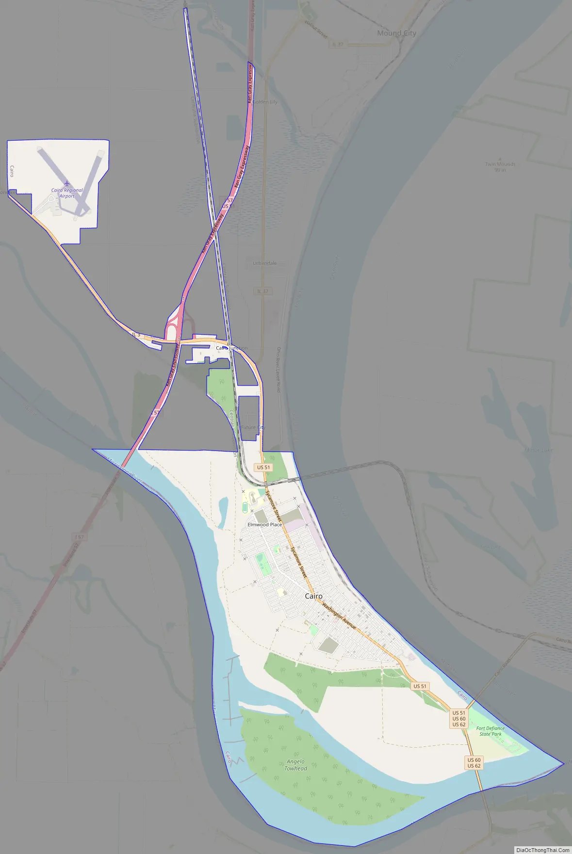
Cairo Road Map
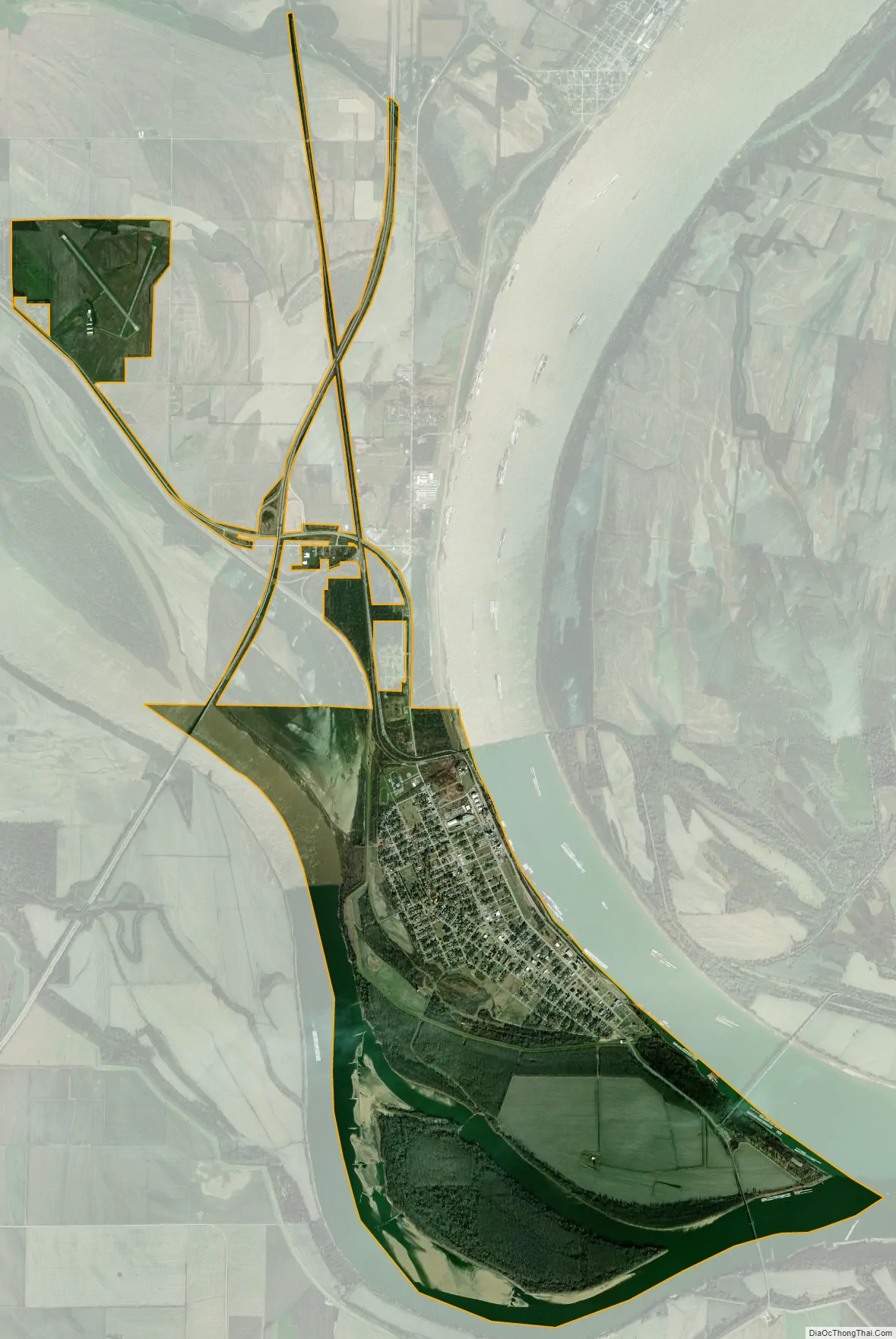
Cairo city Satellite Map
Geography
Cairo is located at the confluence of the Ohio River with the Mississippi, near Mounds, Illinois. The elevation above sea level is 315 feet (96 m). The lowest point in the state of Illinois is located in Cairo at the Mississippi River.
According to the 2021 census gazetteer files, Cairo has a total area of 9.11 square miles (23.59 km), of which 6.99 square miles (18.10 km) (or 76.72%) is land and 2.12 square miles (5.49 km) (or 23.28%) is water.
Climate
The city of Cairo has a humid subtropical climate (Köppen Cfa) and has many characteristics of a city in the Upland South. Summers are warm and humid, with a daily average in July of 79 °F (26.1 °C) and temperatures reaching 90 °F (32 °C) on an average of 40 days annually. Winters are generally cool with mild periods, though extended stretches of cold can occur. Cairo’s winter is typically mild by Illinois standards, as the January daily average is 34 °F (1.1 °C). Precipitation is spread relatively uniformly throughout the year. On average, Cairo’s low elevation and proximity to the Mississippi and Ohio rivers prevent strong winter lows and plunging temperatures; however, during the summer months, those similar features retain heat and humidity, creating muggy conditions.
See also
Map of Illinois State and its subdivision:- Adams
- Alexander
- Bond
- Boone
- Brown
- Bureau
- Calhoun
- Carroll
- Cass
- Champaign
- Christian
- Clark
- Clay
- Clinton
- Coles
- Cook
- Crawford
- Cumberland
- De Kalb
- De Witt
- Douglas
- Dupage
- Edgar
- Edwards
- Effingham
- Fayette
- Ford
- Franklin
- Fulton
- Gallatin
- Greene
- Grundy
- Hamilton
- Hancock
- Hardin
- Henderson
- Henry
- Iroquois
- Jackson
- Jasper
- Jefferson
- Jersey
- Jo Daviess
- Johnson
- Kane
- Kankakee
- Kendall
- Knox
- La Salle
- Lake
- Lake Michigan
- Lawrence
- Lee
- Livingston
- Logan
- Macon
- Macoupin
- Madison
- Marion
- Marshall
- Mason
- Massac
- McDonough
- McHenry
- McLean
- Menard
- Mercer
- Monroe
- Montgomery
- Morgan
- Moultrie
- Ogle
- Peoria
- Perry
- Piatt
- Pike
- Pope
- Pulaski
- Putnam
- Randolph
- Richland
- Rock Island
- Saint Clair
- Saline
- Sangamon
- Schuyler
- Scott
- Shelby
- Stark
- Stephenson
- Tazewell
- Union
- Vermilion
- Wabash
- Warren
- Washington
- Wayne
- White
- Whiteside
- Will
- Williamson
- Winnebago
- Woodford
- Alabama
- Alaska
- Arizona
- Arkansas
- California
- Colorado
- Connecticut
- Delaware
- District of Columbia
- Florida
- Georgia
- Hawaii
- Idaho
- Illinois
- Indiana
- Iowa
- Kansas
- Kentucky
- Louisiana
- Maine
- Maryland
- Massachusetts
- Michigan
- Minnesota
- Mississippi
- Missouri
- Montana
- Nebraska
- Nevada
- New Hampshire
- New Jersey
- New Mexico
- New York
- North Carolina
- North Dakota
- Ohio
- Oklahoma
- Oregon
- Pennsylvania
- Rhode Island
- South Carolina
- South Dakota
- Tennessee
- Texas
- Utah
- Vermont
- Virginia
- Washington
- West Virginia
- Wisconsin
- Wyoming