West City is a village in Franklin County, Illinois, adjacent to the county seat of Benton. The population was 661 at the 2010 census.
| Name: | West City village |
|---|---|
| LSAD Code: | 47 |
| LSAD Description: | village (suffix) |
| State: | Illinois |
| County: | Franklin County |
| Elevation: | 440 ft (130 m) |
| Total Area: | 1.63 sq mi (4.21 km²) |
| Land Area: | 1.61 sq mi (4.16 km²) |
| Water Area: | 0.02 sq mi (0.04 km²) |
| Total Population: | 656 |
| Population Density: | 407.96/sq mi (157.52/km²) |
| Area code: | 618 |
| FIPS code: | 1780073 |
| GNISfeature ID: | 420808 |
| Website: | www.villageofwestcity.com |
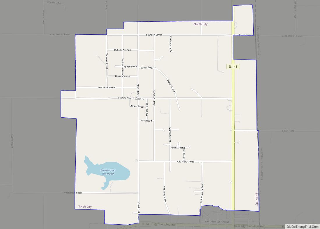
Online Interactive Map
Click on ![]() to view map in "full screen" mode.
to view map in "full screen" mode.
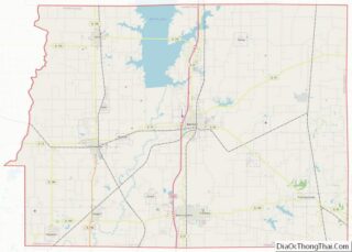
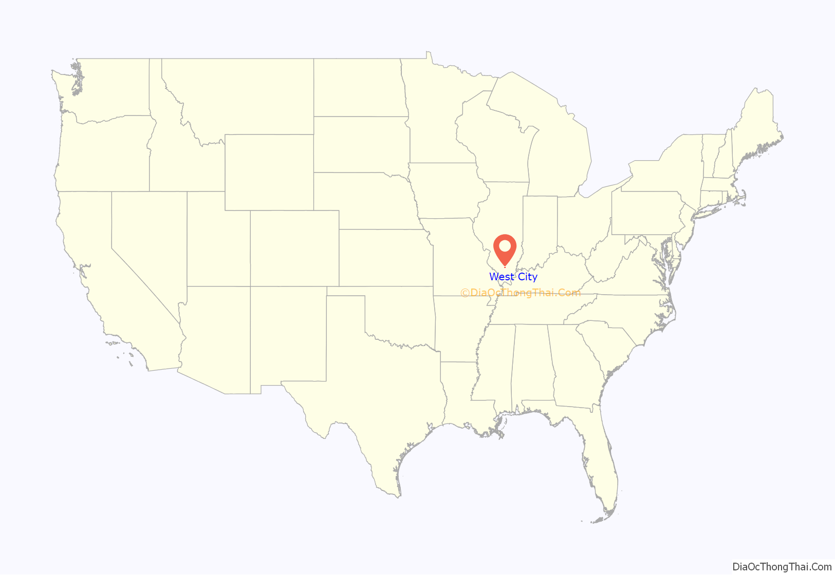
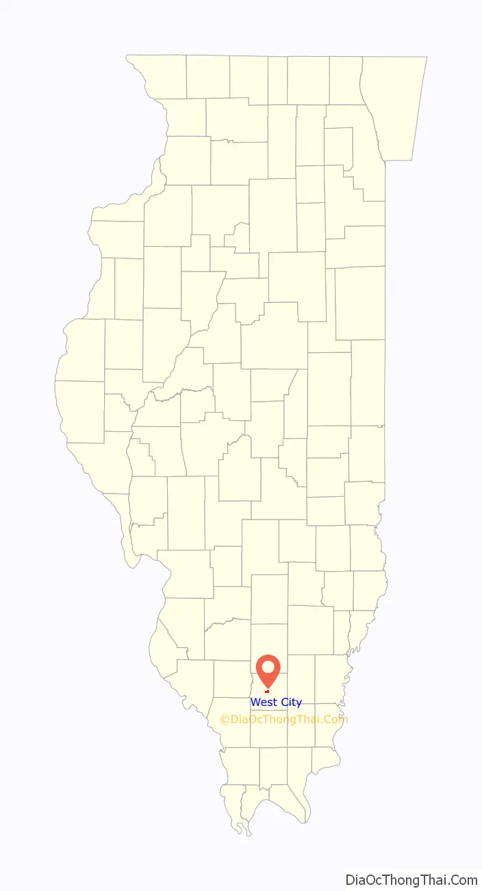
West City location map. Where is West City village?
History
In the late 19th century, West City was a small settlement adjoining Benton on the west. In the early 20th century many immigrants from Poland, Lithuania, and England settled in the West City area to work in the numerous coal mines.
On March 29, 1911, 33 citizens led by John Mulkey and represented by attorney Robert Hickman presented a petition to Judge Thomas J. Layman of the Franklin County Court to incorporate West City as a village. At that time there were 350 inhabitants. An election was held on April 15, 1911, and six trustees were elected: Ed McIntire, J. J. Sanders, L. I. Tombly, Ben Fletcher, Marshall Moore, and Jack Adams. On June 1, 1911, Judge Layman declared West City to be duly and legally organized under the general laws of the State of Illinois as the Village of West City.
When Congress passed the Volstead Act establishing national prohibition in 1919, West City became notorious for bootlegging and gambling. The Birger and Shelton Brothers gangs vied for control of illegal activities in the area. In April 1923, 34-year-old Joseph A. Adams, a huge man of nearly 300 pounds (140 kg) and a roadhouse operator, was elected mayor of West City. Leslie Reed was elected City Clerk. John Lairsey served as Treasurer and R. E. Neunlist was Village Attorney. The six elected trustees were Bruce Panchard, C. C. Gant, George Clinton, H. E. Stewart, W.R. Rogers, and R. N. Long.
Mayor Adams aligned himself with the Shelton Brothers Gang, thus becoming the bitter enemy of Charlie Birger and his men. On December 12, 1926, two of Birger’s men knocked on Adams’ door and told his wife they had a message for him. When Adams came to the door, they shot him in front of his wife Beulah and young daughter Arian. Sheriff Jim Pritchard gathered evidence and arrested Birger for the murder of Mayor Joe Adams.
Birger was tried in Benton and found guilty of ordering the killing, a charge he steadfastly denied. Birger was hanged in Benton on April 19, 1928, at 9:48 a.m., in the last public hanging in Illinois. A replica of the gallows was built in the 1990s by Birchard Wampler and his late son Birchard Neil Wampler. It stands today next to the old Franklin County Jail (now a museum).
After the sensational downfall of the Birger gang and the repeal of the Volstead Act in 1933, West City earned much of its income from legitimate taverns and nightclubs. During the 1940s and ’50s this proved to be a very lucrative business.
Despite West City’s notorious reputation during the 1920s, churches were established by the residents. Prospect, later called First Baptist, was the only organized church in the corporate limits of West City until 1921. Later Trinity Baptist and Harmony Freewill Baptist were established. Trinity Baptist is no longer in existence.
At one time there were three schools in West City limits: Old Jordon, Washington School and New Jordon School, located on South Central Street across from the present West City Village Hall.
On December 21, 1951, West City and all of Franklin County mourned 119 coal miners, who were killed in an underground explosion at C.W. & F. Orient #2 coal mine in West Frankfort.
In 1963, Interstate 57 split the village of West City down the middle from north to south. Preliminary work of buying homes and clearing the right of way began for the construction of Interstate 57 from Chicago to Cairo. Actual highway construction began in 1964, and its completion took nearly 10 years.
With the advent of I-57, Rend Lake Plaza was initiated in 1978. Wal-Mart and Big John’s Supermarket were completed and in operation 1979. Many restaurants and various businesses soon followed, along with two big-city stoplights.
In 1978 a new Village Hall was built and West City expanded their police department, street and water department and the volunteer fire department.
West City Road Map
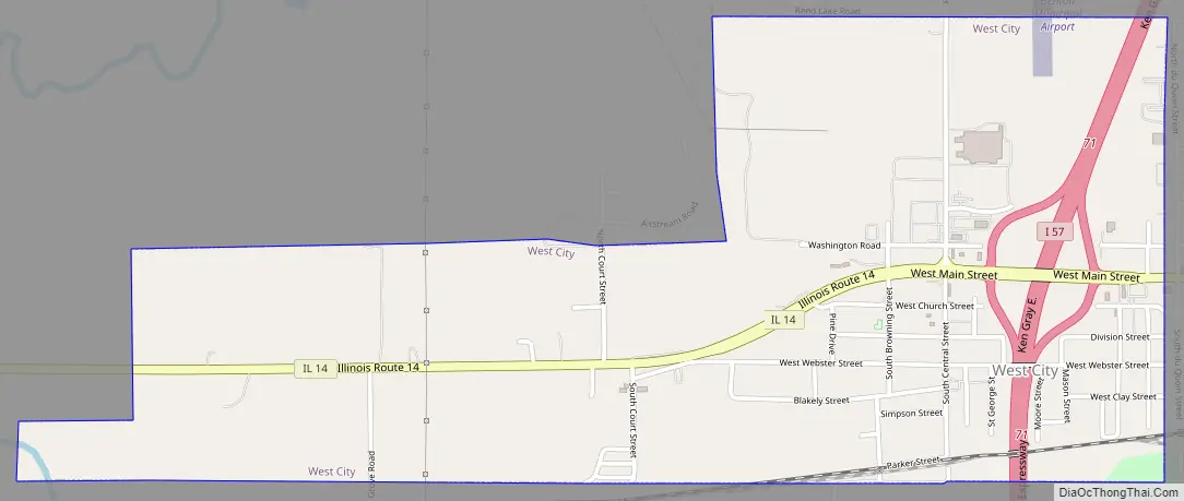
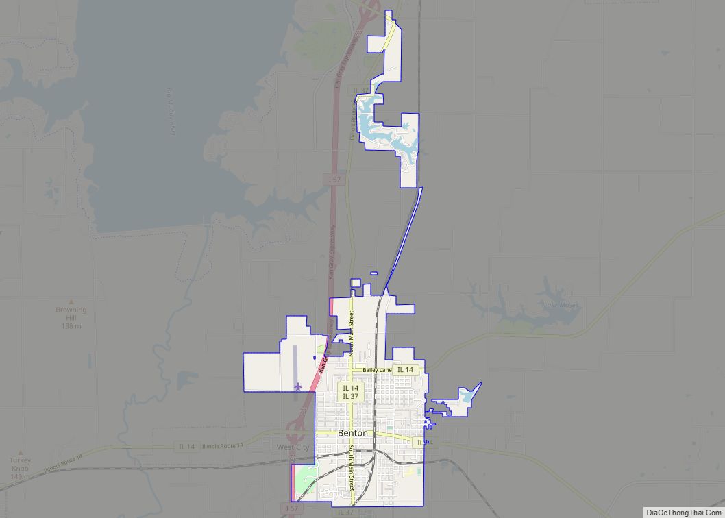
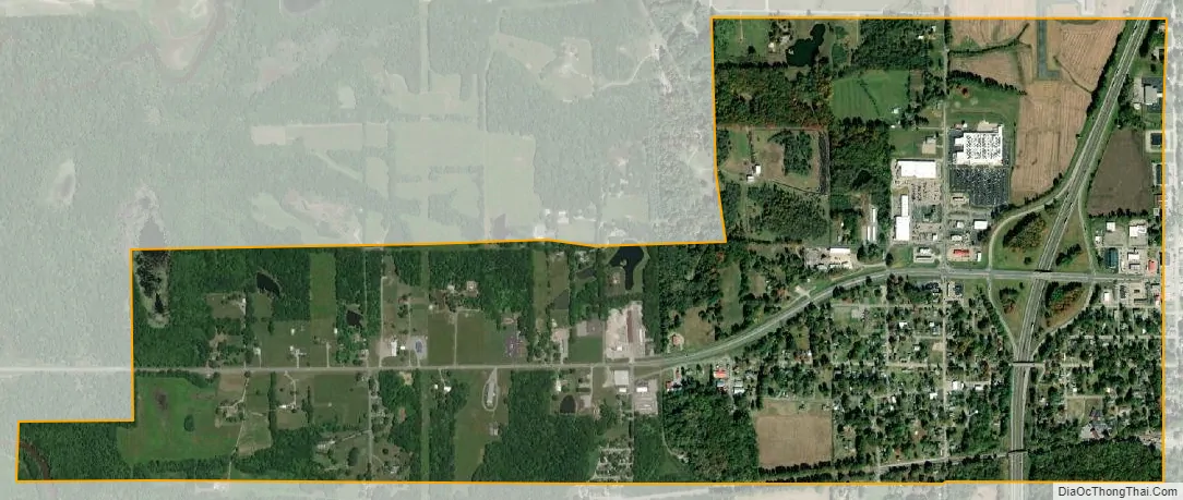
West City city Satellite Map
Geography
West City is located at 37°59′40″N 88°56′30″W / 37.99444°N 88.94167°W / 37.99444; -88.94167 (37.994564, -88.941639). It is bordered to the east and north by the city of Benton, the Franklin County seat. Interstate 57 passes through the center of West City, with access from Exit 71. I-57 leads north 23 miles (37 km) to Mount Vernon and south 20 miles (32 km) to Marion.
According to the 2010 census, West City has a total area of 1.627 square miles (4.21 km), of which 1.61 square miles (4.17 km) (or 98.96%) is land and 0.017 square miles (0.04 km) (or 1.04%) is water.
See also
Map of Illinois State and its subdivision:- Adams
- Alexander
- Bond
- Boone
- Brown
- Bureau
- Calhoun
- Carroll
- Cass
- Champaign
- Christian
- Clark
- Clay
- Clinton
- Coles
- Cook
- Crawford
- Cumberland
- De Kalb
- De Witt
- Douglas
- Dupage
- Edgar
- Edwards
- Effingham
- Fayette
- Ford
- Franklin
- Fulton
- Gallatin
- Greene
- Grundy
- Hamilton
- Hancock
- Hardin
- Henderson
- Henry
- Iroquois
- Jackson
- Jasper
- Jefferson
- Jersey
- Jo Daviess
- Johnson
- Kane
- Kankakee
- Kendall
- Knox
- La Salle
- Lake
- Lake Michigan
- Lawrence
- Lee
- Livingston
- Logan
- Macon
- Macoupin
- Madison
- Marion
- Marshall
- Mason
- Massac
- McDonough
- McHenry
- McLean
- Menard
- Mercer
- Monroe
- Montgomery
- Morgan
- Moultrie
- Ogle
- Peoria
- Perry
- Piatt
- Pike
- Pope
- Pulaski
- Putnam
- Randolph
- Richland
- Rock Island
- Saint Clair
- Saline
- Sangamon
- Schuyler
- Scott
- Shelby
- Stark
- Stephenson
- Tazewell
- Union
- Vermilion
- Wabash
- Warren
- Washington
- Wayne
- White
- Whiteside
- Will
- Williamson
- Winnebago
- Woodford
- Alabama
- Alaska
- Arizona
- Arkansas
- California
- Colorado
- Connecticut
- Delaware
- District of Columbia
- Florida
- Georgia
- Hawaii
- Idaho
- Illinois
- Indiana
- Iowa
- Kansas
- Kentucky
- Louisiana
- Maine
- Maryland
- Massachusetts
- Michigan
- Minnesota
- Mississippi
- Missouri
- Montana
- Nebraska
- Nevada
- New Hampshire
- New Jersey
- New Mexico
- New York
- North Carolina
- North Dakota
- Ohio
- Oklahoma
- Oregon
- Pennsylvania
- Rhode Island
- South Carolina
- South Dakota
- Tennessee
- Texas
- Utah
- Vermont
- Virginia
- Washington
- West Virginia
- Wisconsin
- Wyoming