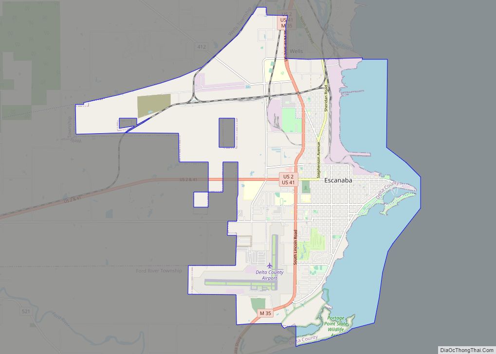
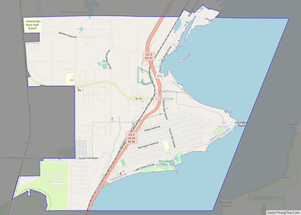
Gladstone is a city in Delta County in the Upper Peninsula of the U.S. state of Michigan. First settled in 1877, Gladstone’s original name was Minnewasca. The population is 5,257 according to the 2020 census.
U.S. Highways 2 and 41 run concurrently through the city, connecting with Escanaba, nine miles (14 km) to the south. US 41 runs north to Marquette and US 2 runs east to Manistique and St. Ignace. M-35 runs northwest 52 miles (84 km) to Gwinn and merges with US 2/US 41 south to Escanaba.
| Name: | Gladstone city |
|---|---|
| LSAD Code: | 25 |
| LSAD Description: | city (suffix) |
| State: | Michigan |
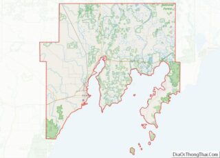
| County: | Delta County |
| Incorporated: | 1887 (village) 1889 (city) |
| Elevation: | 604 ft (184 m) |
| Total Area: | 7.99 sq mi (20.69 km²) |
| Land Area: | 5.07 sq mi (13.12 km²) |
| Water Area: | 2.92 sq mi (7.57 km²) |
| Total Population: | 5,257 |
| Population Density: | 1,037.70/sq mi (400.67/km²) |
| Area code: | 906 |
| FIPS code: | 2632300 |
| GNISfeature ID: | 1620021 |
Online Interactive Map
Click on ![]() to view map in "full screen" mode.
to view map in "full screen" mode.
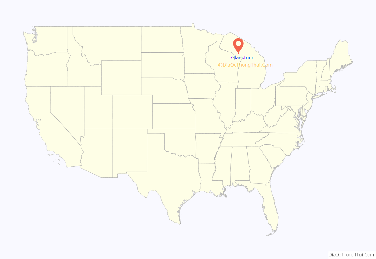
Gladstone location map. Where is Gladstone city?

History
First inhabitants
The first people to occupy the Upper Peninsula of Michigan were Algonquin speaking peoples.
Gladstone was first settled by European descendants in 1859 when the Hamilton Corporation of Fayette began using it as a shipping point for selling and transporting their iron ore.
The town was originally named Minnewasca by the Soo Line Railroad, the Ojibwa name meaning “white water.” When the name was filed with the county and Secretary of State in Lansing, Senator W. D. Washburn, who had an interest in building the railroad, persuaded officials to change the name to Gladstone in honor of British premier, William Ewart Gladstone.
The earliest development was on Saunder’s Point, named for Capt. Nate Saunders who headquartered there when fishing at various points along the bay. It was the location for the initial build-up of Gladstone. Today, Saunder’s Point still exists as a small peninsula east of Gladstone’s city park system, located in Little Bay De Noc.
Expanding beyond its iron ore roots into a shipping point for lumber, coal, and copper during the American civil war, throughout the 1860s and 1870s, Gladstone grew into a busy port.
Change of name
In 1876, the Hamilton Corporation had to move its operations when their mine dried up. The new mine location, further south, meant shipping their ore through the Escanaba port. Arthur Delano, the president of Soo Line Railroad, had commissioned a train depot built in Saunder’s Point during the previous winter to start land shipping for the Hamilton Corporation. However, since this was no longer possible, Delano began commissioning local industries.
Gladstone was incorporated as a village in 1887 and as a city in 1889. Gladstone is named after the English statesman William Ewart Gladstone.
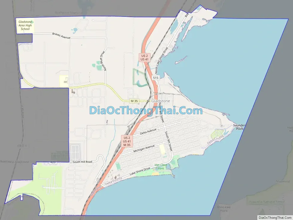
Gladstone Road Map
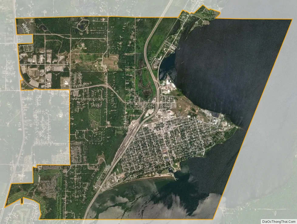
Gladstone city Satellite Map
Geography
The city is located on a small projection into the Little Bay de Noc, which opens onto Green Bay on Lake Michigan.
According to the United States Census Bureau, the city has a total area of 7.92 square miles (20.51 km), of which 5.00 square miles (12.95 km) is land and 2.92 square miles (7.56 km) is water.
Gladstone has a humid continental climate, with cold winters and warm summers. The average temperature in January is around 16°F (-9°C), while the average temperature in July is around 66°F (19°C). Gladstone receives an average of 36 inches of snow and 33 inches of rainfall per year.
Neighborhoods
Although Gladstone is a relatively small city, it has several distinct sections: Downtown (which hosts most of the local businesses), The Buckeye (located on the western side of the city, bordering the Brampton, MI township), and the Bluff (which hosts most of the new residential expansion, as well as Gladstone High School). Gladstone High School sports teams are referred to as the Braves, which along with the Escanaba Eskymos give Delta County two schools bearing indigenous symbols although Eskimo is spelled Eskymo to reflect the nickname “Esky”.
Climate
Due to the city’s proximity to Lake Michigan, Gladstone consistently has high humidity and experiences four distinct seasons. Summers are warm and humid, with average high temperatures in the mid 80s and average lows in the mid 60s. Winters are cold, snowy and windy with temperatures often below freezing. Spring and fall are mild with low humidity. According to the National Weather Service, Gladstone’s record low comes in at -60 on January 7, 1896 [1]. To this day, this storm is referred to by Gladstone residents as “les morte a doigts,” since so many of the city’s residents lost fingers due to frostbite. On July 19, 1992, Gladstone experienced a rare tornado which caused moderate damage throughout the city.
See also
Map of Michigan State and its subdivision:- Alcona
- Alger
- Allegan
- Alpena
- Antrim
- Arenac
- Baraga
- Barry
- Bay
- Benzie
- Berrien
- Branch
- Calhoun
- Cass
- Charlevoix
- Cheboygan
- Chippewa
- Clare
- Clinton
- Crawford
- Delta
- Dickinson
- Eaton
- Emmet
- Genesee
- Gladwin
- Gogebic
- Grand Traverse
- Gratiot
- Hillsdale
- Houghton
- Huron
- Ingham
- Ionia
- Iosco
- Iron
- Isabella
- Jackson
- Kalamazoo
- Kalkaska
- Kent
- Keweenaw
- Lake
- Lake Hurron
- Lake Michigan
- Lake St. Clair
- Lake Superior
- Lapeer
- Leelanau
- Lenawee
- Livingston
- Luce
- Mackinac
- Macomb
- Manistee
- Marquette
- Mason
- Mecosta
- Menominee
- Midland
- Missaukee
- Monroe
- Montcalm
- Montmorency
- Muskegon
- Newaygo
- Oakland
- Oceana
- Ogemaw
- Ontonagon
- Osceola
- Oscoda
- Otsego
- Ottawa
- Presque Isle
- Roscommon
- Saginaw
- Saint Clair
- Saint Joseph
- Sanilac
- Schoolcraft
- Shiawassee
- Tuscola
- Van Buren
- Washtenaw
- Wayne
- Wexford
- Alabama
- Alaska
- Arizona
- Arkansas
- California
- Colorado
- Connecticut
- Delaware
- District of Columbia
- Florida
- Georgia
- Hawaii
- Idaho
- Illinois
- Indiana
- Iowa
- Kansas
- Kentucky
- Louisiana
- Maine
- Maryland
- Massachusetts
- Michigan
- Minnesota
- Mississippi
- Missouri
- Montana
- Nebraska
- Nevada
- New Hampshire
- New Jersey
- New Mexico
- New York
- North Carolina
- North Dakota
- Ohio
- Oklahoma
- Oregon
- Pennsylvania
- Rhode Island
- South Carolina
- South Dakota
- Tennessee
- Texas
- Utah
- Vermont
- Virginia
- Washington
- West Virginia
- Wisconsin
- Wyoming