Olivette is an inner-ring suburb of St. Louis, located in St. Louis County, Missouri, United States. The population was 8,504 at the 2020 census.
| Name: | Olivette city |
|---|---|
| LSAD Code: | 25 |
| LSAD Description: | city (suffix) |
| State: | Missouri |
| County: | St. Louis County |
| Elevation: | 676 ft (206 m) |
| Total Area: | 2.77 sq mi (7.18 km²) |
| Land Area: | 2.77 sq mi (7.18 km²) |
| Water Area: | 0.00 sq mi (0.00 km²) |
| Total Population: | 8,504 |
| Population Density: | 3,068.93/sq mi (1,185.13/km²) |
| FIPS code: | 2954650 |
| GNISfeature ID: | 2396056 |
| Website: | http://www.olivettemo.com |
Online Interactive Map
Click on ![]() to view map in "full screen" mode.
to view map in "full screen" mode.
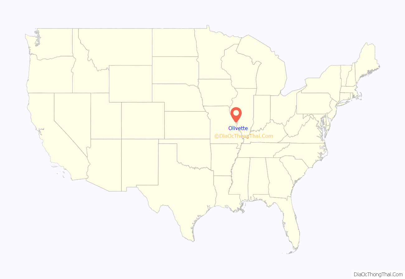
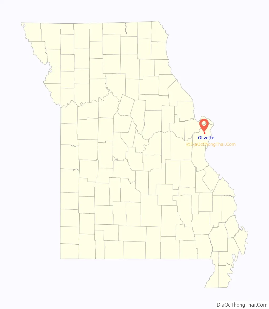
Olivette location map. Where is Olivette city?
History
Olivette was settled in the mid-19th century as a small farming community along an old Indian trail originally called the Bonhomme Road (now known as Old Bonhomme, which meets and essentially turns into Olive Boulevard). Olive Road is a ridge road and at one time served as a de facto boundary for housing segregation in outer St. Louis.
The first brick schoolhouse in St. Louis County was built in the 1850s at the corner of Price and Old Bonhomme in Olivette. Logos High School is built on the former grounds of the schoolhouse.
In the 1920s, St. Louis decided to build a water reservoir in Olivette since it was one of the highest points in St. Louis County. The reservoir was built at Brock’s Pond, a local recreational spot, and finished in 1926. Stacy Park was formed around the reservoir and is now the largest park in Olivette.
Olivette was incorporated in 1930 by combining the communities of Central, Tower Hill, Olive, and Stratmann. Prior to merging, the area was known as Central due to its centralized location along the Central Plank Road (again, now called Olive Boulevard). In fact, Price Road and Olive Boulevard intersect at the exact midpoint between the Port of St. Louis on the Mississippi River and Howell’s Landing on the Missouri River. Central was a high traffic stop for wagons to restock on their journey between the two stops. O.
Olivette is one of the few communities in St. Louis County that maintains their own municipal fire department and police department.
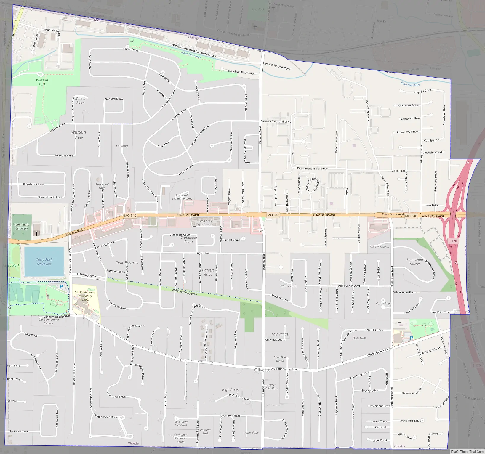
Olivette Road Map
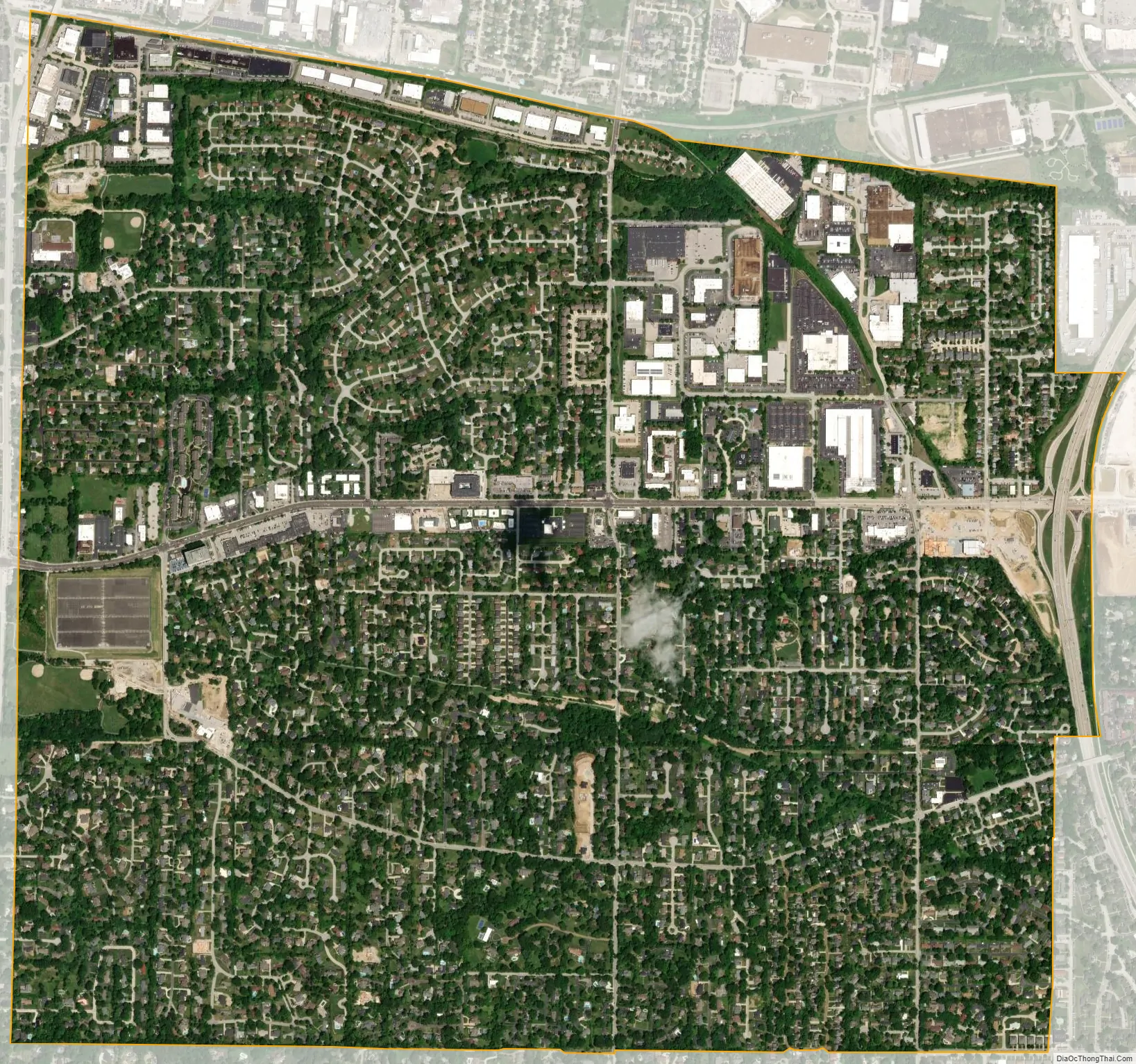
Olivette city Satellite Map
Geography
According to the United States Census Bureau, the city has a total area of 2.78 square miles (7.20 km), all land.
Key roads through Olivette include Missouri Route 340 (Olive Boulevard), Price Road, Dielman Road, Old Bonhomme Road and Interstate 170.
Olivette’s neighbors include Overland and unincorporated St. Louis County to the north, Creve Coeur to the west, Ladue to the south, and University City to the east. The Monsanto Corporation used to be located partially in Olivette until it was acquired by Bayer in 2018.
See also
Map of Missouri State and its subdivision:- Adair
- Andrew
- Atchison
- Audrain
- Barry
- Barton
- Bates
- Benton
- Bollinger
- Boone
- Buchanan
- Butler
- Caldwell
- Callaway
- Camden
- Cape Girardeau
- Carroll
- Carter
- Cass
- Cedar
- Chariton
- Christian
- Clark
- Clay
- Clinton
- Cole
- Cooper
- Crawford
- Dade
- Dallas
- Daviess
- De Kalb
- Dent
- Douglas
- Dunklin
- Franklin
- Gasconade
- Gentry
- Greene
- Grundy
- Harrison
- Henry
- Hickory
- Holt
- Howard
- Howell
- Iron
- Jackson
- Jasper
- Jefferson
- Johnson
- Knox
- Laclede
- Lafayette
- Lawrence
- Lewis
- Lincoln
- Linn
- Livingston
- Macon
- Madison
- Maries
- Marion
- McDonald
- Mercer
- Miller
- Mississippi
- Moniteau
- Monroe
- Montgomery
- Morgan
- New Madrid
- Newton
- Nodaway
- Oregon
- Osage
- Ozark
- Pemiscot
- Perry
- Pettis
- Phelps
- Pike
- Platte
- Polk
- Pulaski
- Putnam
- Ralls
- Randolph
- Ray
- Reynolds
- Ripley
- Saint Charles
- Saint Clair
- Saint Francois
- Saint Louis
- Sainte Genevieve
- Saline
- Schuyler
- Scotland
- Scott
- Shannon
- Shelby
- Stoddard
- Stone
- Sullivan
- Taney
- Texas
- Vernon
- Warren
- Washington
- Wayne
- Webster
- Worth
- Wright
- Alabama
- Alaska
- Arizona
- Arkansas
- California
- Colorado
- Connecticut
- Delaware
- District of Columbia
- Florida
- Georgia
- Hawaii
- Idaho
- Illinois
- Indiana
- Iowa
- Kansas
- Kentucky
- Louisiana
- Maine
- Maryland
- Massachusetts
- Michigan
- Minnesota
- Mississippi
- Missouri
- Montana
- Nebraska
- Nevada
- New Hampshire
- New Jersey
- New Mexico
- New York
- North Carolina
- North Dakota
- Ohio
- Oklahoma
- Oregon
- Pennsylvania
- Rhode Island
- South Carolina
- South Dakota
- Tennessee
- Texas
- Utah
- Vermont
- Virginia
- Washington
- West Virginia
- Wisconsin
- Wyoming


