Springfield is the third largest city in the U.S. state of Missouri and the county seat of Greene County. The city’s population was 169,176 at the 2020 census. It is the principal city of the Springfield metropolitan area, which had an estimated population of 481,483 in 2021 and includes the counties of Christian, Dallas, Greene, Polk, and Webster, and is the fastest growing metropolitan area in the state of Missouri.
Springfield’s nickname is “Queen City of the Ozarks” as well as “The 417” after the area code for the city. It is also known as the “Birthplace of Route 66”. It is home to several universities and colleges, including Missouri State University, Drury University, and Evangel University. The city is an important center of education and medical care, with two of the largest hospitals in the area, CoxHealth and Mercy, employing over 20,000 people combined, and being the largest employers in the region. It has been called the “Buckle of the Bible Belt” due to its association with evangelical Christianity. The city and surrounding area have been growing more diverse over the decades. Between the 2010 and 2020 censuses, the population of Greene County grew by over 23,700 people, largely as a result of immigration.
The city sits on the Springfield Plateau of the Ozarks. Due to its proximity to the mountainous area, the city is known for its outdoor recreation activities. The city holds nearly 100 city parks and 140 miles (230 km) of outdoor bike trails. The city is the headquarters for Bass Pro Shops, which is the number one tourist attraction in the state of Missouri, and the adjoining Wonders of Wildlife Museum & Aquarium is the world’s largest wildlife attraction. Springfield is within close distance to Wilson’s Creek National Battlefield and sits along the Trail of Tears, now a national historic trail.
| Name: | Springfield city |
|---|---|
| LSAD Code: | 25 |
| LSAD Description: | city (suffix) |
| State: | Missouri |
| County: | Christian County, Greene County |
| Founded: | 1834 |
| Incorporated: | 1838 |
| Elevation: | 1,299 ft (396 m) |
| Land Area: | 83.11 sq mi (215.26 km²) |
| Water Area: | 0.59 sq mi (1.52 km²) |
| Population Density: | 2,035.49/sq mi (785.91/km²) |
| ZIP code: | 65800-65899 |
| Area code: | 417 |
| FIPS code: | 2970000 |
| GNISfeature ID: | 0735864 |
| Website: | www.springfieldmo.gov |
Online Interactive Map
Click on ![]() to view map in "full screen" mode.
to view map in "full screen" mode.
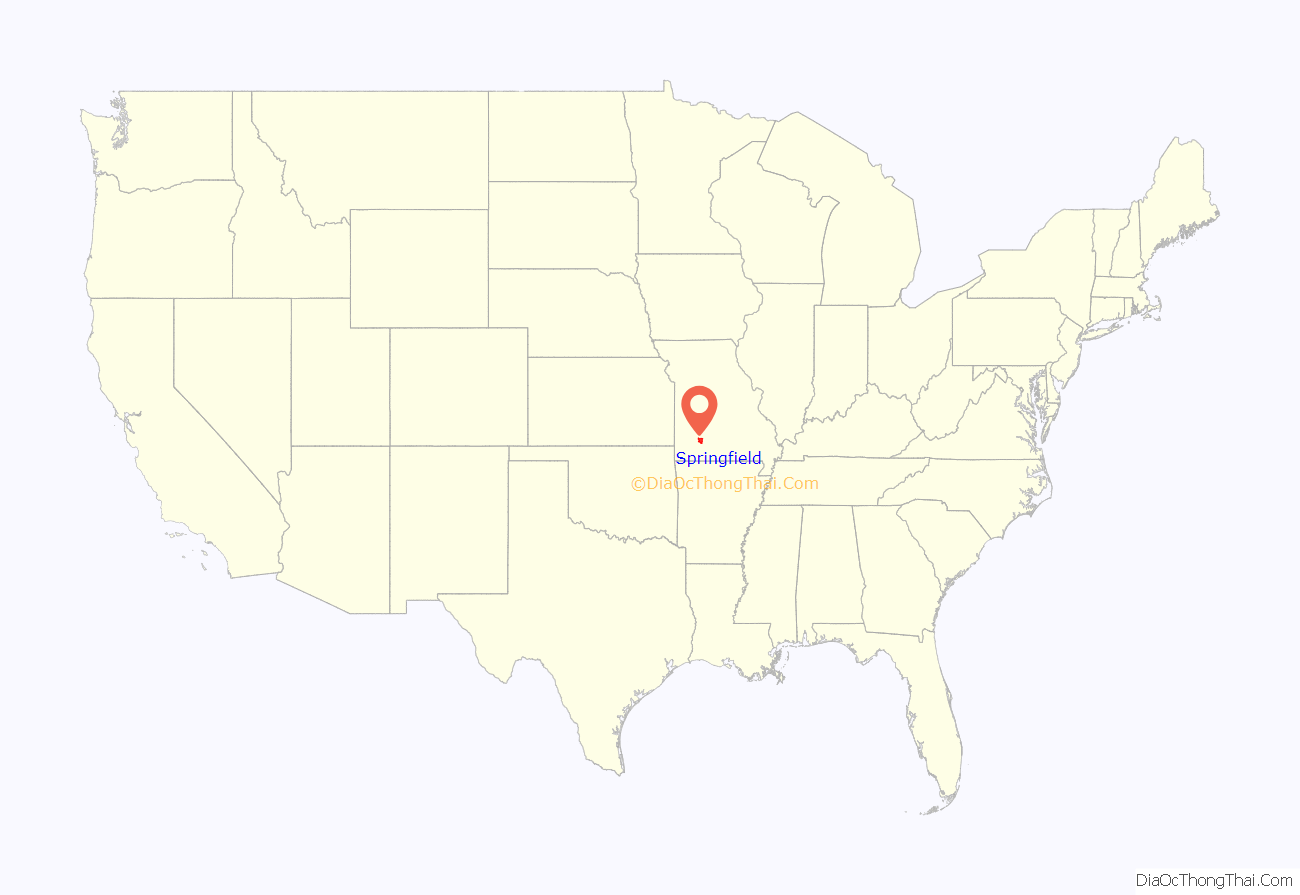
Springfield location map. Where is Springfield city?
History
The origin of the city’s name is unclear, but the most common view is that it was named for Springfield, Massachusetts, by migrants from that area. One account holds that James Wilson, who lived in the then unnamed city, offered free whiskey to anyone who would vote for the name Springfield, after his hometown in Massachusetts.
The editor of the Springfield Express, J. G. Newbill, said in the November 11, 1881, issue:
In 1883, historian R. I. Holcombe wrote:
Early settlement
The presence of the Native Americans in the area slowed the European-American settlement of the land. Long before the 1830s, the native Kickapoo and Osage, and the Lenape (Delaware) from the mid-Atlantic coast had settled in this general area. The Osage had been the dominant tribe for more than a century in the larger region.
On the southeastern side of the city in 1812, about 500 Kickapoo Native Americans built a small village of about 100 wigwams. They abandoned the site in 1828. Ten miles south of the site of Springfield, the Lenape had built a substantial dwelling of houses that borrowed elements of Anglo colonial style from the mid-Atlantic, where their people had migrated from.
The first European-American settlers to the area were John Polk Campbell and his brother, who moved to the area in 1829 from Tennessee. Campbell chose the area because of the presence of a natural well that flowed into a small stream. He staked his claim by carving his initials in a tree. Campbell was joined by settlers Thomas Finney, Samuel Weaver, and Joseph Miller. They cleared the land of trees to develop it for farms. A small general store was soon opened.
In 1833, the southern part of the state was named Greene County after Revolutionary War hero General Nathanael Greene. Campbell Township was one of the seven original townships organized on March 11, 1833, when Greene County was much larger. An 1876 map shows it boundaries include all the sections in T29N and R21 and 22W. It was bounded by Center Township on the west, Robberson, and Franklin Townships on the north, Taylor Township on the east, and Wilson and Clay Townships on the south. (Later, Campbell was split into Campbell No. 1 Township and Campbell No. 2 Township, then into North Campbell No. 1 Township, North Campbell No. 2 Township, and North Campbell No. 3 Township.)
The county seat of Springfield is located in Campbell Township due to the efforts of John Polk Campbell. The township is named after John Polk Campbell, who donated the land for Springfield’s public square and platted the town site. He deeded 50 acres of land to the legislature for the creation of a county seat in 1835. Campbell laid out city streets and lots. The town was incorporated in 1838. In 1878, the town got its nickname the “Queen City of the Ozarks.”
The United States government enforced Indian Removal during the 1830s, forcing land cessions in the Southeast and other areas, and relocating tribes to Indian Territory, which later developed as Oklahoma. During the 1838 relocation of Cherokee natives, the Trail of Tears passed through Springfield to the west, along the Old Wire Road.
Civil War
By 1861, Springfield’s population had grown to approximately 2,000, and it had become an important commercial hub. In the late 1850s, telegraph lines, previously only to St. Louis, reached Springfield. News from point further west was brought to Springfield overland and then sent by telegraph to what was then called the New York Associated Press. At the start of the American Civil War, Springfield was divided in its loyalty, as it had been settled by people from both the North and South, as well as by German immigrants in the mid-19th century who tended to support the Union.
The Union and Confederate armies both recognized the city’s strategic importance and sought to control it. They fought the Battle of Wilson’s Creek on August 10, 1861, a few miles southwest of town. The battle was a Confederate victory, and Nathaniel Lyon became the first Union General killed in Civil War. Union troops retreated to Lebanon to regroup. When they returned, they found that most of the Confederate army had withdrawn.
On October 25, 1861, Union Major Charles Zagonyi led an attack against the remaining Confederates in the area, in a battle known as the First Battle of Springfield, or Zagonyi’s Charge. Zagonyi’s men removed the Confederate flag from Springfield’s public square and returned to camp. It was the only Union victory in southwestern Missouri in 1861. The increased military activity in the area set the stage for the Battle of Pea Ridge in northern Arkansas in March 1862.
On January 8, 1863, Confederate forces under General John S. Marmaduke advanced to take control of Springfield and an urban fight ensued. But that evening, the Confederates withdrew. This became known as the Second Battle of Springfield. Marmaduke sent a message to the Union forces asking that the Confederate casualties have a proper burial. The city remained under Union control for the remainder of the war. The US army used Springfield as a supply base and central point of operation for military activities in the area.
Promptly after the Civil War ended on July 21, 1865, Wild Bill Hickok shot and killed Davis Tutt in a shootout over a disagreement about a debt Tutt claimed Hickok owed him. During a poker game at the former Lyon House Hotel, in response to the disagreement over the amount, Tutt had taken Hickok’s watch, which Hickok demanded he return immediately. Hickok warned that Tutt had better not be seen wearing that watch, then spotted him wearing it in Park Central Square, prompting the gunfight.
On January 25, 1866, Hickok was still in Springfield when he witnessed a Springfield police officer, John Orr, shoot and kill James Coleman after Coleman interfered with the arrest of Coleman’s friend Bingham, who was drunk and disorderly. Hickok provided testimony in the case. Orr was arrested, released on bail, and immediately fled the country. He was never brought to trial or heard from again.
Race relations
From the period after Reconstruction into the early 20th century, lynchings of freedmen and their descendants occurred in some cities and counties in Missouri, particularly in former slaveholding areas.
On April 14, 1906, a white mob broke into the Springfield county jail, and lynched two black men, Horace Duncan and Fred Coker, for allegedly sexually assaulting Mina Edwards, a white woman. Later they returned to the jail, where other African-American prisoners were being held, and pulled out Will Allen, who had been accused of murdering a white man. All three suspects were hanged from the Gottfried Tower, which held a replica of the Statue of Liberty, and burned in the courthouse square by a mob of more than 2,000 citizens. Judge Azariah W. Lincoln called for a grand jury, but no one was prosecuted. The proceedings were covered by national newspapers, the New York Times and Los Angeles Times.
Duncan’s and Coker’s employer testified that they were at his business at the time of the crime against Edwards, and other evidence suggested that they and Allen were all innocent. These three are the only recorded lynchings in Greene County. But the extrajudicial murders were part of a pattern of discrimination, repeated violence and intimidation of African Americans in this city and southwest Missouri from 1894 to 1909, in an attempt to expel them from the region. Whites in Lawrence County also lynched three African-American men in this period. After the mass lynching in Springfield, many African Americans left the area in a large exodus.
A historic plaque on the southeast corner of the Springfield courthouse square commemorates Duncan, Coker, and Allen, the three victims of mob violence.
Country music
Four nationally broadcast television series originated from the city between 1955 and 1961: Ozark Jubilee and its spin-off, Five Star Jubilee; Talent Varieties; and The Eddy Arnold Show. All were carried live by ABC except for Five Star Jubilee on NBC and were produced by Springfield’s Crossroads TV Productions, owned by Ralph D. Foster. Many of the biggest names in country music frequently visited or lived in Springfield at the time. City officials estimated the programs meant about 2,000 weekly visitors and “over $1,000,000 in fresh income.”
Staged at the Jewell Theatre (demolished in 1961), Ozark Jubilee was the first national country music TV show to feature top stars and attract a significant viewership. Five Star Jubilee, produced from the Landers Theatre, was the first network color television series to originate outside of New York City or Hollywood. Ironically, Springfield’s NBC affiliate, KYTV-TV (which helped produce the program), was not equipped to broadcast in color and aired the show in black-and-white.
The ABC, NBC and Mutual radio networks also all carried country music shows nationally from Springfield during the decade, including KWTO’S Korn’s-A-Krackin’ (Mutual).
The Ozark Hillbilly Medallion
The Springfield Chamber of Commerce once presented visiting dignitaries with an “Ozark Hillbilly Medallion” and a certificate proclaiming the honoree a “hillbilly of the Ozarks”. On June 7, 1953, U.S. President Harry Truman received the medallion after a breakfast speech (Archived June 7, 2011, at the Wayback Machine) at the Shrine Mosque for a reunion of the 35th Division. Other recipients included US Army generals Omar Bradley and Matthew Ridgway, US Representative Dewey Short, J. C. Penney, Johnny Olson, Ralph Story and disc jockey Nelson King.
Springfield Road Map
Springfield city Satellite Map
Geography
Springfield is on the Springfield Plateau of the Ozarks region of southwest Missouri. According to the United States Census Bureau, the city has a total area of 82.31 square miles (213.2 square kilometres), of which 81.72 square miles (211.7 square kilometres) is land and 0.59 square miles (1.5 square kilometres) (0.7%) is water.
The city of Springfield is mainly flat with rolling hills and cliffs surrounding its south, east, and north sections. Springfield is on the Springfield Plateau, which reaches from Northwest Arkansas to Central Missouri. Most of the plateau is characterized by forest, pastures and shrub-scrub habitats. Many streams and tributaries, such as the James River, Galloway Creek and Jordan Creek, flow within or near the city. Nearby lakes include Table Rock Lake, Stockton Lake, McDaniel Lake, Fellows Lake, Lake Springfield, and Pomme de Terre Lake. Springfield is near the population center of the United States, about 80 miles (130 km) to the east.
Climate
Springfield has an average surface wind velocity comparable to Chicago’s, according to information compiled at the National Climatic Data Center at NOAA. It is placed within “Power Class 3” in the Wind Energy Resource Atlas published by a branch of the U.S. Department of Energy; having an average wind speed range of 6.4 to 7.0 miles per hour.
Springfield lies in the northern limits of a humid subtropical climate (Cfa), as defined by the Köppen climate classification system. As such, it experiences times of exceptional humidity; especially in late summer. The monthly daily average temperature ranges from 34.3 °F (1.3 °C) in January to 79.2 °F (26.2 °C) in July. On average, there are 40 days of 90 °F (32 °C)+ highs, 2 days of 100 °F (38 °C)+ highs, 15 days where the high fails to rise above freezing, and 1.3 nights of lows at or below 0 °F (−18 °C) per year. It has an average annual precipitation of 44.71 inches (1,140 mm), including an average 13.70 inches (34.8 cm) of snow. Extremes in temperature range from −29 °F (−34 °C) on February 12, 1899 up to 113 °F (45 °C) on July 14, 1954.
According to a 2007 story in Forbes magazine’s list of “America’s Wildest Weather Cities” and the Weather Variety Index, Springfield is the city with the most varied weather in the United States. On May 1, 2013, Springfield reached a high temperature of 81 degrees Fahrenheit. By the evening of May 2, snow was falling, persisting into the following day and eventually accumulating to about two inches.
See also
Map of Missouri State and its subdivision:- Adair
- Andrew
- Atchison
- Audrain
- Barry
- Barton
- Bates
- Benton
- Bollinger
- Boone
- Buchanan
- Butler
- Caldwell
- Callaway
- Camden
- Cape Girardeau
- Carroll
- Carter
- Cass
- Cedar
- Chariton
- Christian
- Clark
- Clay
- Clinton
- Cole
- Cooper
- Crawford
- Dade
- Dallas
- Daviess
- De Kalb
- Dent
- Douglas
- Dunklin
- Franklin
- Gasconade
- Gentry
- Greene
- Grundy
- Harrison
- Henry
- Hickory
- Holt
- Howard
- Howell
- Iron
- Jackson
- Jasper
- Jefferson
- Johnson
- Knox
- Laclede
- Lafayette
- Lawrence
- Lewis
- Lincoln
- Linn
- Livingston
- Macon
- Madison
- Maries
- Marion
- McDonald
- Mercer
- Miller
- Mississippi
- Moniteau
- Monroe
- Montgomery
- Morgan
- New Madrid
- Newton
- Nodaway
- Oregon
- Osage
- Ozark
- Pemiscot
- Perry
- Pettis
- Phelps
- Pike
- Platte
- Polk
- Pulaski
- Putnam
- Ralls
- Randolph
- Ray
- Reynolds
- Ripley
- Saint Charles
- Saint Clair
- Saint Francois
- Saint Louis
- Sainte Genevieve
- Saline
- Schuyler
- Scotland
- Scott
- Shannon
- Shelby
- Stoddard
- Stone
- Sullivan
- Taney
- Texas
- Vernon
- Warren
- Washington
- Wayne
- Webster
- Worth
- Wright
- Alabama
- Alaska
- Arizona
- Arkansas
- California
- Colorado
- Connecticut
- Delaware
- District of Columbia
- Florida
- Georgia
- Hawaii
- Idaho
- Illinois
- Indiana
- Iowa
- Kansas
- Kentucky
- Louisiana
- Maine
- Maryland
- Massachusetts
- Michigan
- Minnesota
- Mississippi
- Missouri
- Montana
- Nebraska
- Nevada
- New Hampshire
- New Jersey
- New Mexico
- New York
- North Carolina
- North Dakota
- Ohio
- Oklahoma
- Oregon
- Pennsylvania
- Rhode Island
- South Carolina
- South Dakota
- Tennessee
- Texas
- Utah
- Vermont
- Virginia
- Washington
- West Virginia
- Wisconsin
- Wyoming
