Plano is a city near Aurora in Kendall County, Illinois, United States, with a population of 11,847 as of the 2020 census. It is part of the Chicago metropolitan area, being about 55 miles (90 km) from Chicago. The city was home to the Plano Harvester Company in the late 19th century, as well as the Plano Molding Company more recently. In 2011, downtown Plano was used as a set for Man of Steel.
| Name: | Plano city |
|---|---|
| LSAD Code: | 25 |
| LSAD Description: | city (suffix) |
| State: | Illinois |
| County: | Kendall County |
| Founded: | April 10, 1872 |
| Elevation: | 633 ft (193 m) |
| Total Area: | 9.02 sq mi (23.37 km²) |
| Land Area: | 8.98 sq mi (23.26 km²) |
| Water Area: | 0.04 sq mi (0.11 km²) |
| Total Population: | 11,847 |
| Population Density: | 1,319.41/sq mi (509.43/km²) |
| ZIP code: | 60545 |
| FIPS code: | 1760352 |
| GNISfeature ID: | 2396223 |
| Website: | www.cityofplanoil.com |
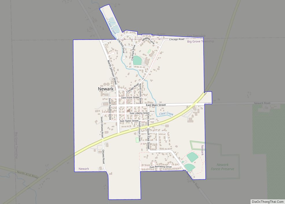
Online Interactive Map
Click on ![]() to view map in "full screen" mode.
to view map in "full screen" mode.
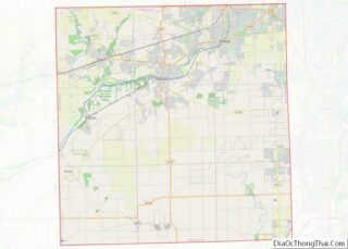
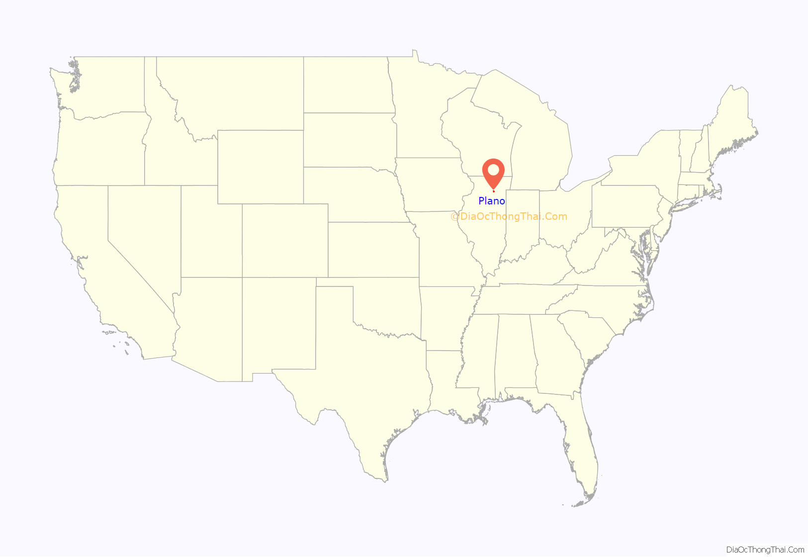
Plano location map. Where is Plano city?

History
In the early 1860s, the Marsh brothers began producing their Marsh Harvester in Plano. From 1863 to the beginning of the twentieth century the Plano Manufacturing Company, as it became known, provided the foundation for Plano’s development. Because of this, Plano High School has adopted the reaper as its mascot.
Plano was the one-time headquarters for the Reorganized Church of Jesus Christ of Latter Day Saints. Joseph Smith III, son of slain LDS movement founder Joseph Smith, Jr., moved to Plano in 1866 and ran the church’s printing operation from there. As the schism with the Utah branch of the Latter Day Saints deepened, he moved with the church headquarters to Lamoni, Iowa in 1880 to be closer to what the Community of Christ believed to be the true church headquarters at Temple Lot in Missouri rather than in Utah.
Community development has been centered around a strong agricultural setting, with the only inhabitants of the area before its incorporation being the owners of grist mills. This development was supported by the city’s location along US Route 34 and the Illinois Zephyr Amtrak passenger rail service.
The Plano Molding Company, manufacturer of fishing tackle equipment as well as other plastic domestic containment units, has its headquarters in Plano. Both of its original factories within Plano are still in operation, but the main bulk of production is now in nearby cities Sandwich and Mendota.
Plano and Sandwich have developed a sibling-like relationship. Both deeply agricultural cities are situated along a major trading route and rail artery. The two cities’ high schools have developed a rivalry that has become known to the local press as the “War on 34”, due to their location along US Route 34.
In the early twenty-first century, multiple new housing developments were constructed in Plano. Due to the following economic downturn, however, many of the houses in both the new developments and older parts of town have experienced foreclosures. Nonetheless, Waubonsee Community College opened a satellite campus in Plano in late 2011.
In the summer of 2011, the City of Plano was used for exterior filming for the Superman movie, Man of Steel. Various farms around the city were also used with one being used for the Kent family farm, and the downtown area was remodeled and turned into a set for downtown Smallville. Other areas used for filming were nearby, and part of IL 56, north of Sugar Grove was shut down for two days for filming despite being closed for “Road Repair”. Plano declared itself Smallville during the filming. Signs have been erected at either end of town, as well as on the end of one building on Main Street, proclaiming a similar declaration. Additionally, a “Smallville Superfest” was organized the following summer, and has since been held annually in August.
The Farnsworth House
Master Architect Ludwig Mies van der Rohe had worked on a retreat for Dr. Edith Farnsworth, a doctor from Chicago, whose complicated relationship with the architect soured the project. Cost overruns as well as questions on the house’s actual usefulness led to a lawsuit between the two parties, with van der Rohe winning the suit. In later years, the County Board decided to buy some of Farnsworth’s land in order to straighten Fox River Drive (Ben Street in Plano), which would need a new bridge as well. Farnsworth pleaded her case to the County Board, citing evidence that the Board would be doing construction on an old Indian Site, but to no avail. The road was straightened and the new bridge built; however, to this day, the old bridge piers are still visible. Around the same time, Silver Springs State Park and Wildlife Area was designated, down the road and across the river from Farnsworth’s house, forever protecting the land from development.
Plano Road Map

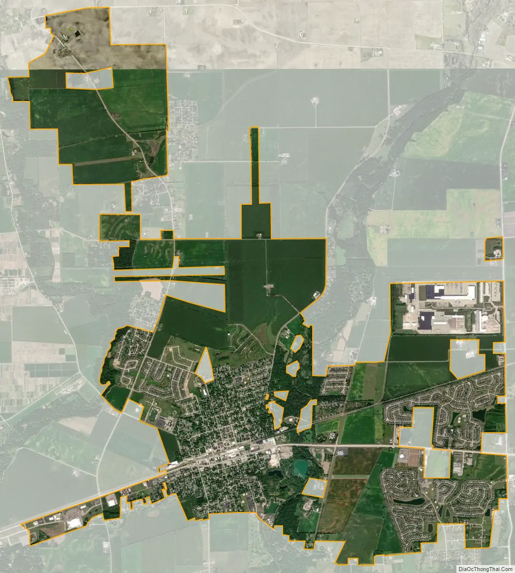
Plano city Satellite Map
Geography
According to the 2010 census, Plano has a total area of 7.503 square miles (19.43 km), of which 7.46 square miles (19.32 km) (or 99.43%) is land and 0.043 square miles (0.11 km) (or 0.57%) is water.
See also
Map of Illinois State and its subdivision:- Adams
- Alexander
- Bond
- Boone
- Brown
- Bureau
- Calhoun
- Carroll
- Cass
- Champaign
- Christian
- Clark
- Clay
- Clinton
- Coles
- Cook
- Crawford
- Cumberland
- De Kalb
- De Witt
- Douglas
- Dupage
- Edgar
- Edwards
- Effingham
- Fayette
- Ford
- Franklin
- Fulton
- Gallatin
- Greene
- Grundy
- Hamilton
- Hancock
- Hardin
- Henderson
- Henry
- Iroquois
- Jackson
- Jasper
- Jefferson
- Jersey
- Jo Daviess
- Johnson
- Kane
- Kankakee
- Kendall
- Knox
- La Salle
- Lake
- Lake Michigan
- Lawrence
- Lee
- Livingston
- Logan
- Macon
- Macoupin
- Madison
- Marion
- Marshall
- Mason
- Massac
- McDonough
- McHenry
- McLean
- Menard
- Mercer
- Monroe
- Montgomery
- Morgan
- Moultrie
- Ogle
- Peoria
- Perry
- Piatt
- Pike
- Pope
- Pulaski
- Putnam
- Randolph
- Richland
- Rock Island
- Saint Clair
- Saline
- Sangamon
- Schuyler
- Scott
- Shelby
- Stark
- Stephenson
- Tazewell
- Union
- Vermilion
- Wabash
- Warren
- Washington
- Wayne
- White
- Whiteside
- Will
- Williamson
- Winnebago
- Woodford
- Alabama
- Alaska
- Arizona
- Arkansas
- California
- Colorado
- Connecticut
- Delaware
- District of Columbia
- Florida
- Georgia
- Hawaii
- Idaho
- Illinois
- Indiana
- Iowa
- Kansas
- Kentucky
- Louisiana
- Maine
- Maryland
- Massachusetts
- Michigan
- Minnesota
- Mississippi
- Missouri
- Montana
- Nebraska
- Nevada
- New Hampshire
- New Jersey
- New Mexico
- New York
- North Carolina
- North Dakota
- Ohio
- Oklahoma
- Oregon
- Pennsylvania
- Rhode Island
- South Carolina
- South Dakota
- Tennessee
- Texas
- Utah
- Vermont
- Virginia
- Washington
- West Virginia
- Wisconsin
- Wyoming