St. Charles is a city in DuPage and Kane counties in the U.S. state of Illinois. It lies roughly 40 miles (64 km) west of Chicago on Illinois Route 64. Per the 2020 census, the population was 33,081. The official city slogan is “Pride of the Fox”, after the Fox River that runs through the center of town. St. Charles is part of a tri-city area along with Geneva and Batavia, all western suburbs of similar size and socioeconomic condition.
| Name: | St. Charles city |
|---|---|
| LSAD Code: | 25 |
| LSAD Description: | city (suffix) |
| State: | Illinois |
| County: | DuPage County, Kane County |
| Founded: | 1834 (as Charleston; changed to St. Charles in 1839) |
| Total Area: | 15.01 sq mi (38.87 km²) |
| Land Area: | 14.41 sq mi (37.32 km²) |
| Water Area: | 0.60 sq mi (1.55 km²) |
| Total Population: | 33,081 |
| Population Density: | 2,295.86/sq mi (886.43/km²) |
| Area code: | 630 |
| FIPS code: | 1766703 |
| Website: | www.stcharlesil.gov |
Online Interactive Map
Click on ![]() to view map in "full screen" mode.
to view map in "full screen" mode.
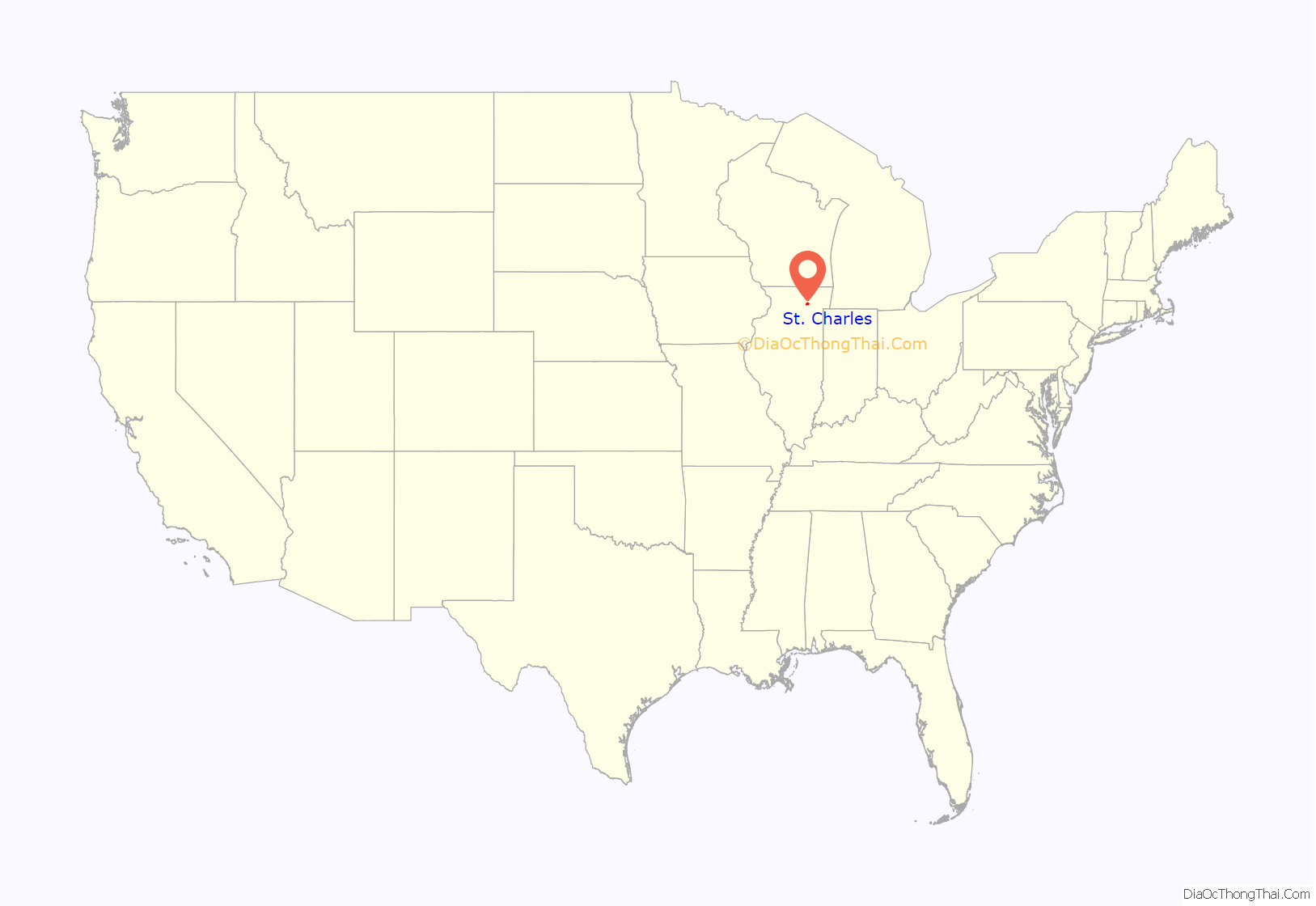
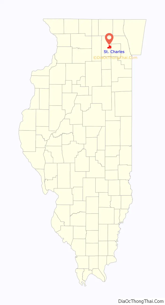
St. Charles location map. Where is St. Charles city?
History
Early history
St. Charles was the location of the Native American community for the chief of the Pottawatomie that inhabited the area. A city park overlooking the river was dedicated to this Native American past. After the Black Hawk War in 1832, the entire area of the Fox Valley was opened to American settlement. Evan Shelby and William Franklin staked the first claim in what is now St. Charles in 1833. They came back in 1834 with their families from Indiana, and were joined by over a dozen other families later that year. The township was initially known as Charleston, but this name was already taken by the downstate city of Charleston, Illinois, so the name of St. Charles (suggested by S. S. Jones, a lawyer) was adopted in 1839. St. Charles became incorporated as a city February 9, 1839, and reincorporated October 17, 1874 (under the 1870 Illinois Constitution).
Underground Railroad
Widespread claims of slavery-era Underground Railroad stations operating in St. Charles homes, complete with tunnels and false doorways, have not been historically substantiated. Even so, an active abolitionist group was operating in St. Charles around this time, called the Kane County Anti-Slavery Society. The Society was founded in 1842 and had about 180 members at its peak. The most plausible connection to the Underground Railroad in the town is the Wheeler House, built in St. Charles in 1837.
Transportation history
St. Charles was a very isolated place early on in its existence. The village was located three days away from Chicago, and the Fox River was not navigable for large boats. By the 1850s, St. Charles had begun construction of a plank road to Sycamore but turned down an offer by the Galena and Chicago Union Railroad to construct a line through the town, which was eventually built in nearby Elgin. Lack of regional connections in the early years kept the town relatively small. St. Charles was without a railroad until 1871 when a branch line from Geneva was constructed, and was without a direct connection to Chicago until the 1880s with the coming of the Chicago Great Western Railway.
Streetcar lines along the Fox River between Elgin and Aurora were built through the city in 1896, operated by the Aurora, Elgin and Fox River Electric company. A direct automobile route to Chicago, which eventually became Route 64 (Main Street), was constructed in 1920. Four Illinois state routes, including Routes 64, 38 (Lincoln Highway), 25 (5th Avenue), and 31 (2nd Street) now run through the city. Two major Kane County roads also cut through the city; Randall Road on the west side and Kirk Road on the east side.
Immigration history
St. Charles has attracted groups of European immigrants, including from Ireland and Sweden during the 1840s and 1850s, and later from Belgium and Lithuania.
COVID-19 pandemic
On April 25, 2020 (3 years ago) (2020-04-25), the Kane County Health Department ordered Smithfield Foods to close its meat processing plant because of the COVID-19 pandemic, a local instance of the pandemic’s effects on the meat industry in the United States.
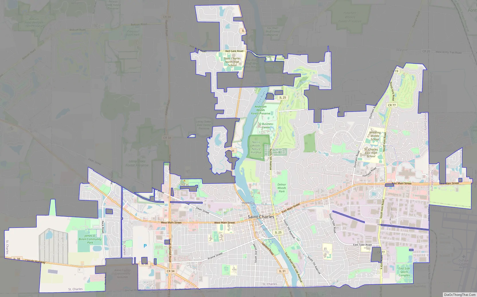
St. Charles Road Map
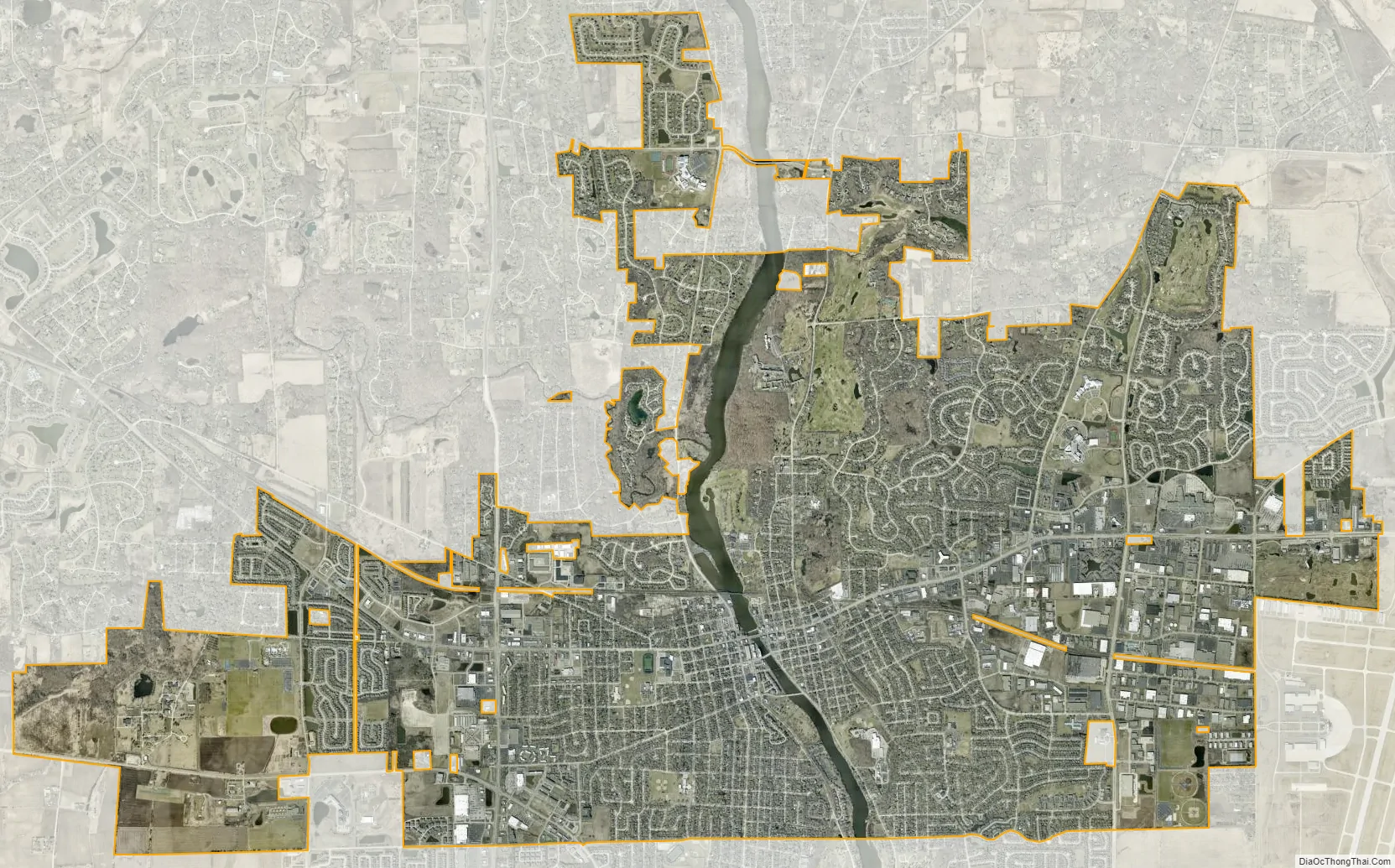
St. Charles city Satellite Map
Geography
According to the 2021 census gazetteer files, St. Charles has a total area of 15.01 square miles (38.88 km), of which 14.41 square miles (37.32 km) (or 96.00%) is land and 0.60 square miles (1.55 km) (or 4.00%) is water.
The Fox River runs through downtown. Potawatomie Park, which sits on the river, is the largest park in St. Charles and a popular destination for both tourists and tri-city area citizens.
See also
Map of Illinois State and its subdivision:- Adams
- Alexander
- Bond
- Boone
- Brown
- Bureau
- Calhoun
- Carroll
- Cass
- Champaign
- Christian
- Clark
- Clay
- Clinton
- Coles
- Cook
- Crawford
- Cumberland
- De Kalb
- De Witt
- Douglas
- Dupage
- Edgar
- Edwards
- Effingham
- Fayette
- Ford
- Franklin
- Fulton
- Gallatin
- Greene
- Grundy
- Hamilton
- Hancock
- Hardin
- Henderson
- Henry
- Iroquois
- Jackson
- Jasper
- Jefferson
- Jersey
- Jo Daviess
- Johnson
- Kane
- Kankakee
- Kendall
- Knox
- La Salle
- Lake
- Lake Michigan
- Lawrence
- Lee
- Livingston
- Logan
- Macon
- Macoupin
- Madison
- Marion
- Marshall
- Mason
- Massac
- McDonough
- McHenry
- McLean
- Menard
- Mercer
- Monroe
- Montgomery
- Morgan
- Moultrie
- Ogle
- Peoria
- Perry
- Piatt
- Pike
- Pope
- Pulaski
- Putnam
- Randolph
- Richland
- Rock Island
- Saint Clair
- Saline
- Sangamon
- Schuyler
- Scott
- Shelby
- Stark
- Stephenson
- Tazewell
- Union
- Vermilion
- Wabash
- Warren
- Washington
- Wayne
- White
- Whiteside
- Will
- Williamson
- Winnebago
- Woodford
- Alabama
- Alaska
- Arizona
- Arkansas
- California
- Colorado
- Connecticut
- Delaware
- District of Columbia
- Florida
- Georgia
- Hawaii
- Idaho
- Illinois
- Indiana
- Iowa
- Kansas
- Kentucky
- Louisiana
- Maine
- Maryland
- Massachusetts
- Michigan
- Minnesota
- Mississippi
- Missouri
- Montana
- Nebraska
- Nevada
- New Hampshire
- New Jersey
- New Mexico
- New York
- North Carolina
- North Dakota
- Ohio
- Oklahoma
- Oregon
- Pennsylvania
- Rhode Island
- South Carolina
- South Dakota
- Tennessee
- Texas
- Utah
- Vermont
- Virginia
- Washington
- West Virginia
- Wisconsin
- Wyoming


