Valdese is a town in Burke County, North Carolina, United States. The population was 4,689 at the 2020 census. It is part of the Hickory–Lenoir–Morganton Metropolitan Statistical Area. One of the largest Waldensian congregations in the United States was founded in the town in the late nineteenth century, now known as the Waldensian Presbyterian Church. The town was settled by immigrants from the Cottian Alps in the Piedmont region of Italy.
| Name: | Valdese town |
|---|---|
| LSAD Code: | 43 |
| LSAD Description: | town (suffix) |
| State: | North Carolina |
| County: | Burke County |
| Incorporated: | 1920 |
| Elevation: | 1,217 ft (371 m) |
| Total Area: | 7.87 sq mi (20.39 km²) |
| Land Area: | 7.86 sq mi (20.36 km²) |
| Water Area: | 0.01 sq mi (0.03 km²) |
| Total Population: | 4,689 |
| Population Density: | 596.56/sq mi (230.35/km²) |
| ZIP code: | 28690 |
| Area code: | 828 |
| FIPS code: | 3769520 |
| GNISfeature ID: | 0996570 |
| Website: | townofvaldese.com |
Online Interactive Map
Click on ![]() to view map in "full screen" mode.
to view map in "full screen" mode.
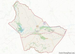
Valdese location map. Where is Valdese town?


History
Settled in 1893 by a group of Waldensians from Northern Italy, the town was incorporated in 1920.
In addition to Waldensian Presbyterian Church, the Jean-Pierre Auguste Dalmas House and Valdese Elementary School are listed on the National Register of Historic Places.
The Valdese News, a newspaper serving Burke County, was published there from 1938 through 1950.
Valdese Road Map

Valdese city Satellite Map

Geography
Valdese is located in eastern Burke County at 35°44′36″N 81°33′31″W / 35.74333°N 81.55861°W / 35.74333; -81.55861 (35.743270, -81.558662). It is bordered to the east by the town of Rutherford College. The Valdese town limits extend north to Rhodhiss Lake on the Catawba River, then follow the land along the southern side of the lake for 4 miles (6 km) to the west.
U.S. Route 70 passes through the town as Main Street, leading west 7 miles (11 km) to the center of Morganton, the county seat, and east 14 miles (23 km) to Hickory. Interstate 40 runs along the southern border of the town, providing access from exits 111 and 112.
According to the United States Census Bureau, the town has a total area of 7.7 square miles (20.0 km), of which 0.012 square miles (0.03 km), or 0.17%, is water.
See also
Map of North Carolina State and its subdivision:- Alamance
- Alexander
- Alleghany
- Anson
- Ashe
- Avery
- Beaufort
- Bertie
- Bladen
- Brunswick
- Buncombe
- Burke
- Cabarrus
- Caldwell
- Camden
- Carteret
- Caswell
- Catawba
- Chatham
- Cherokee
- Chowan
- Clay
- Cleveland
- Columbus
- Craven
- Cumberland
- Currituck
- Dare
- Davidson
- Davie
- Duplin
- Durham
- Edgecombe
- Forsyth
- Franklin
- Gaston
- Gates
- Graham
- Granville
- Greene
- Guilford
- Halifax
- Harnett
- Haywood
- Henderson
- Hertford
- Hoke
- Hyde
- Iredell
- Jackson
- Johnston
- Jones
- Lee
- Lenoir
- Lincoln
- Macon
- Madison
- Martin
- McDowell
- Mecklenburg
- Mitchell
- Montgomery
- Moore
- Nash
- New Hanover
- Northampton
- Onslow
- Orange
- Pamlico
- Pasquotank
- Pender
- Perquimans
- Person
- Pitt
- Polk
- Randolph
- Richmond
- Robeson
- Rockingham
- Rowan
- Rutherford
- Sampson
- Scotland
- Stanly
- Stokes
- Surry
- Swain
- Transylvania
- Tyrrell
- Union
- Vance
- Wake
- Warren
- Washington
- Watauga
- Wayne
- Wilkes
- Wilson
- Yadkin
- Yancey
- Alabama
- Alaska
- Arizona
- Arkansas
- California
- Colorado
- Connecticut
- Delaware
- District of Columbia
- Florida
- Georgia
- Hawaii
- Idaho
- Illinois
- Indiana
- Iowa
- Kansas
- Kentucky
- Louisiana
- Maine
- Maryland
- Massachusetts
- Michigan
- Minnesota
- Mississippi
- Missouri
- Montana
- Nebraska
- Nevada
- New Hampshire
- New Jersey
- New Mexico
- New York
- North Carolina
- North Dakota
- Ohio
- Oklahoma
- Oregon
- Pennsylvania
- Rhode Island
- South Carolina
- South Dakota
- Tennessee
- Texas
- Utah
- Vermont
- Virginia
- Washington
- West Virginia
- Wisconsin
- Wyoming