Fairmont City is a village in St. Clair and Madison counties, Illinois, United States. The population was 2,265 at the 2020 census, down from 2,635 in 2010. In the 1990s Fairmont City’s Hispanic population doubled, and as of 2020, over 79% of the population was of Hispanic descent.
| Name: | Fairmont City village |
|---|---|
| LSAD Code: | 47 |
| LSAD Description: | village (suffix) |
| State: | Illinois |
| County: | Madison County, St. Clair County |
| Elevation: | 420 ft (130 m) |
| Total Area: | 6.55 sq mi (16.96 km²) |
| Land Area: | 6.21 sq mi (16.07 km²) |
| Water Area: | 0.34 sq mi (0.89 km²) |
| Total Population: | 2,265 |
| Population Density: | 365.03/sq mi (140.95/km²) |
| ZIP code: | 62201 |
| Area code: | 618 |
| FIPS code: | 1724933 |
| GNISfeature ID: | 2398855 |
| Website: | www.fairmontcityil.com |
Online Interactive Map
Click on ![]() to view map in "full screen" mode.
to view map in "full screen" mode.
Fairmont City location map. Where is Fairmont City village?


Fairmont City Road Map

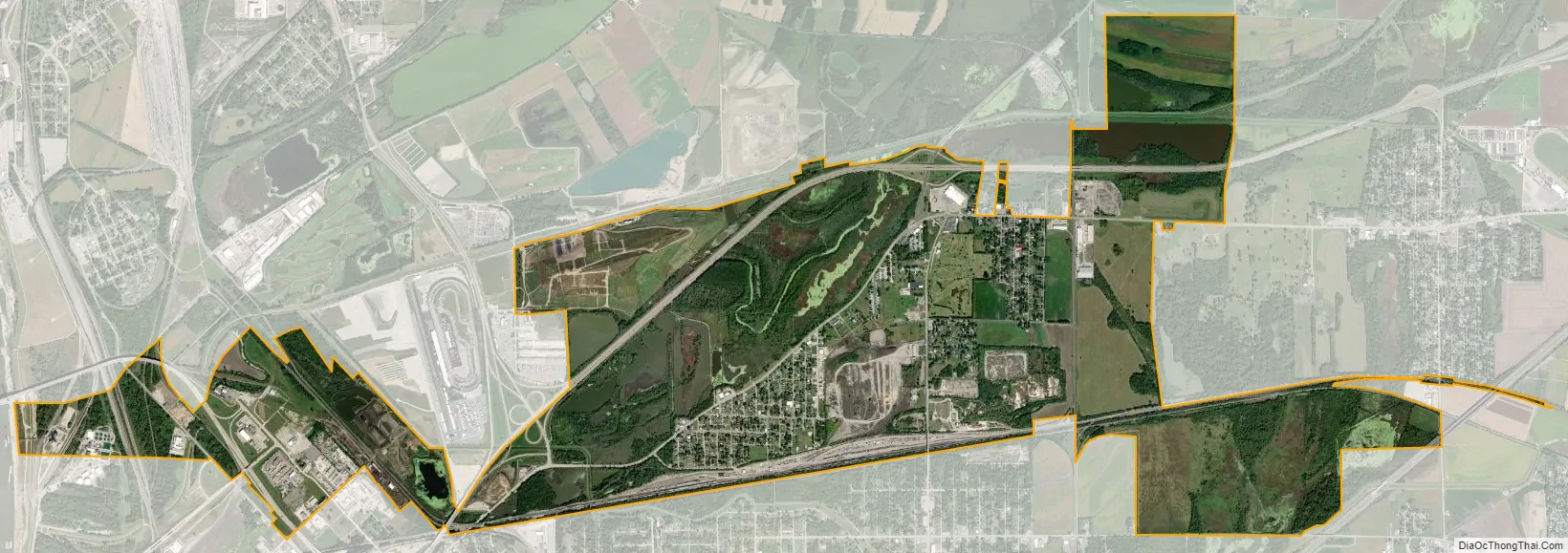
Fairmont City city Satellite Map
Geography
Fairmont City is located in northwestern St. Clair County at 38°39′4″N 90°5′59″W / 38.65111°N 90.09972°W / 38.65111; -90.09972 (38.651200, -90.099788). A small part of the village extends north into southwestern Madison County. The community is bordered to the northwest by Brooklyn, to the north by Madison, to the northeast by Pontoon Beach, to the east by Collinsville, to the southeast by Caseyville, to the south by Washington Park, and to the southwest by East St. Louis. The village limits extend west 3 miles (5 km) from the main portion of Fairmont City to touch the Mississippi River directly across from St. Louis.
According to the U.S. Census Bureau, Fairmont City has a total area of 6.55 square miles (16.96 km), of which 6.21 square miles (16.08 km) are land and 0.34 square miles (0.88 km), or 5.22%, are water.
Fairmont City is built atop portions of the Cahokia Mounds, a UNESCO World Heritage Site. Sam Chucalo Mound, one of the mounds, is in the western part of the village. Other mounds are in the eastern part of the village within Cahokia Mounds State Historic Site.
In April 2016, the US Environmental Protection Agency added the Old American Zinc Fairmont City site to the National Priorities List following the Illinois EPA discovering high levels of lead, arsenic, cadmium and zinc in soil samples. Collected soil samples from properties and alleyways showed residue of arsenic, cadmium and zinc.
Fairmont City is 5 miles (8 km) east of the Gateway Arch of St. Louis. Sunset often provides picturesque views of the arch and St. Louis’ skyline. Collinsville Road runs the length of the village. This route once contained an accumulation of vintage, in situ roadside Americana advertising signage, most of which has not been removed or destroyed over time.
National City, a former company town to the west of Fairmont City, dissolved in 1997 and was annexed by Fairmont City.
See also
Map of Illinois State and its subdivision:- Adams
- Alexander
- Bond
- Boone
- Brown
- Bureau
- Calhoun
- Carroll
- Cass
- Champaign
- Christian
- Clark
- Clay
- Clinton
- Coles
- Cook
- Crawford
- Cumberland
- De Kalb
- De Witt
- Douglas
- Dupage
- Edgar
- Edwards
- Effingham
- Fayette
- Ford
- Franklin
- Fulton
- Gallatin
- Greene
- Grundy
- Hamilton
- Hancock
- Hardin
- Henderson
- Henry
- Iroquois
- Jackson
- Jasper
- Jefferson
- Jersey
- Jo Daviess
- Johnson
- Kane
- Kankakee
- Kendall
- Knox
- La Salle
- Lake
- Lake Michigan
- Lawrence
- Lee
- Livingston
- Logan
- Macon
- Macoupin
- Madison
- Marion
- Marshall
- Mason
- Massac
- McDonough
- McHenry
- McLean
- Menard
- Mercer
- Monroe
- Montgomery
- Morgan
- Moultrie
- Ogle
- Peoria
- Perry
- Piatt
- Pike
- Pope
- Pulaski
- Putnam
- Randolph
- Richland
- Rock Island
- Saint Clair
- Saline
- Sangamon
- Schuyler
- Scott
- Shelby
- Stark
- Stephenson
- Tazewell
- Union
- Vermilion
- Wabash
- Warren
- Washington
- Wayne
- White
- Whiteside
- Will
- Williamson
- Winnebago
- Woodford
- Alabama
- Alaska
- Arizona
- Arkansas
- California
- Colorado
- Connecticut
- Delaware
- District of Columbia
- Florida
- Georgia
- Hawaii
- Idaho
- Illinois
- Indiana
- Iowa
- Kansas
- Kentucky
- Louisiana
- Maine
- Maryland
- Massachusetts
- Michigan
- Minnesota
- Mississippi
- Missouri
- Montana
- Nebraska
- Nevada
- New Hampshire
- New Jersey
- New Mexico
- New York
- North Carolina
- North Dakota
- Ohio
- Oklahoma
- Oregon
- Pennsylvania
- Rhode Island
- South Carolina
- South Dakota
- Tennessee
- Texas
- Utah
- Vermont
- Virginia
- Washington
- West Virginia
- Wisconsin
- Wyoming


