Alton (/ˈɔːltən/ AWL-tən) is a city on the Mississippi River in Madison County, Illinois, United States, about 18 miles (29 km) north of St. Louis, Missouri. The population was 25,676 at the 2020 census. It is a part of the River Bend area in the Metro-East region of the Greater St. Louis metropolitan area. It is famous for its limestone bluffs along the river north of the city, as the former location of the state penitentiary, and for its role preceding and during the American Civil War. It was the site of the last Abraham Lincoln and Stephen Douglas debate in October 1858. The former state penitentiary in Alton was used during the Civil War to hold up to 12,000 Confederate prisoners of war.
| Name: | Alton city |
|---|---|
| LSAD Code: | 25 |
| LSAD Description: | city (suffix) |
| State: | Illinois |
| County: | Madison County |
| Elevation: | 535 ft (163 m) |
| Total Area: | 16.95 sq mi (43.90 km²) |
| Land Area: | 15.67 sq mi (40.59 km²) |
| Water Area: | 1.28 sq mi (3.31 km²) |
| Total Population: | 25,676 |
| Population Density: | 1,638.44/sq mi (632.62/km²) |
| Area code: | 618 |
| FIPS code: | 1701114 |
| GNISfeature ID: | 2393935 |
| Website: | www.cityofaltonil.com |
Online Interactive Map
Click on ![]() to view map in "full screen" mode.
to view map in "full screen" mode.
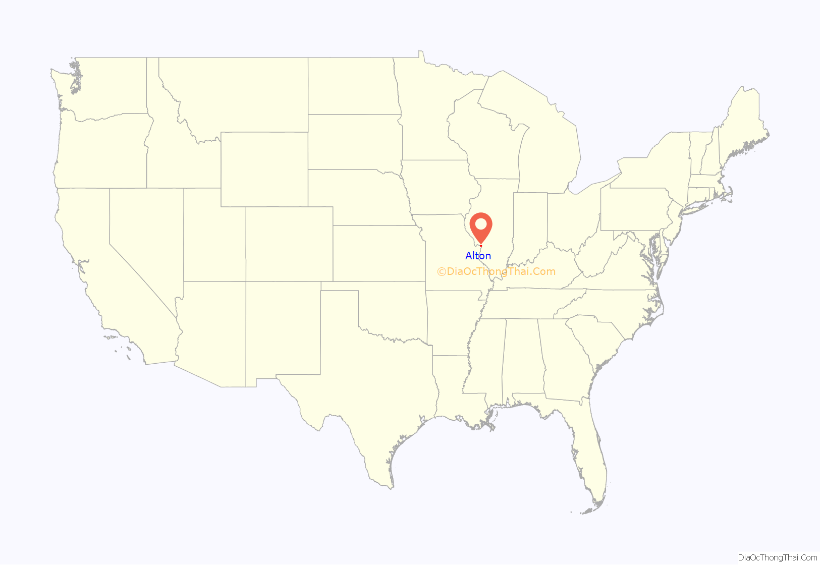
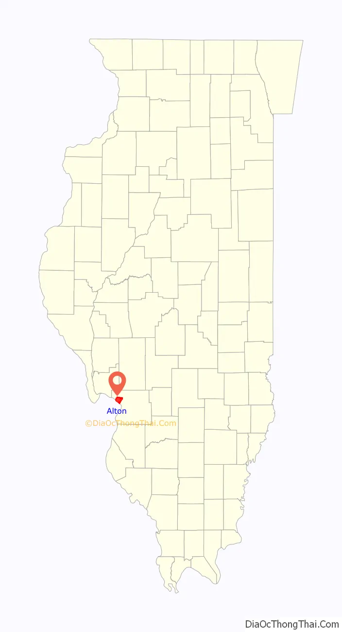
Alton location map. Where is Alton city?
History
Although Alton once was growing faster than the nearby city of St. Louis, a coalition of St. Louis businessmen planned to build a competing town to stop Alton’s expansion and bring business to St. Louis. The resulting town was Grafton, Illinois.
Many blocks of housing in Alton were built in the Victorian Queen Anne style. They represent a prosperous period in the river city’s history. At the top of the hill in the commercial area, several stone churches and a fine city hall also represent the city’s wealth during its good times based on river traffic, manufacturing and shipping. It was a commercial center for a large agricultural area. Numerous residences on hills have sweeping views of the Mississippi River.
Early history
The Alton area was home to Native Americans for thousands of years before the 19th-century founding by European Americans of the modern city. Historic accounts indicate occupation of this area by the Illiniwek or Illinois Confederacy at the time of European contact. Earlier native settlement is demonstrated by archaeological artifacts and the famous prehistoric Piasa bird painted on a cliff face nearby. The image was described in 1673 by French missionary priest Father Jacques Marquette.
19th century
Alton was developed as a river town in January 1818 by Rufus Easton, who named it after his son. Easton ran a passenger ferry service across the Mississippi River to the Missouri shore. Alton is located amid the confluence of three navigable rivers: the Illinois, the Mississippi, and the Missouri. Alton grew into a river trading town with an industrial character. The city rises steeply from the waterfront, where massive concrete grain silos and railroad tracks were constructed in the 19th and 20th centuries to store and ship the area’s grains and produce. Brick commercial buildings are spread throughout downtown. Once the site of several brick factories, Alton has an unusually high number of streets still paved in brick. The lower levels of Alton are subject to floods, many of which have inundated the historic downtown area. The dates of different flood levels are marked on the large grain silos, part of the Ardent Mills, near the Argosy Casino at the waterfront. The flood of 1993 is considered the worst of the last century.
Alton became an important town for abolitionists, as Illinois was a free state across from the slave state of Missouri. Pro-slavery activists also lived there and slave catchers often raided the city. Escaped slaves would cross the Mississippi to seek shelter in Alton, and proceed to safer places through stations of the Underground Railroad. During the years before the American Civil War, several homes were equipped with tunnels and hiding places for stations on the Underground Railroad to aid slaves escaping to the North. On November 7, 1837, the abolitionist printer Reverend Elijah P. Lovejoy was murdered by a pro-slavery mob while he tried to protect his Alton-based press from being destroyed for the third time. He had moved from St. Louis because of opposition there. He had printed many abolitionist tracts and distributed them throughout the area. When one of the mob made a move to set the old warehouse on fire, Lovejoy, armed with only a pistol, went outside to try to stop him. The pro-slavery man shot him dead (with a shotgun, five rounds through the midsection). The mob stormed the warehouse and threw Lovejoy’s printing press into the Mississippi. Lovejoy thus became the first martyr of the abolition movement.
Alton became the seat of a diocese of the Catholic Church in 1857. Its first bishop was French-born Henry Damian Juncker. The new diocese had 58 churches, 18 priests and 50,000 Catholics. When he died, 11 years later, the churches were 125, the priests more than 100, and the Catholics 80,000. He was succeeded by Peter Joseph Baltes from Germany (1869–1886) and James Ryan (1888–1923). In 1923 the bishop’s seat was moved to Springfield, Illinois. The Diocese of Alton, no longer a residential bishopric, is today listed by the Catholic Church as a titular see. Titular bishops appointed to the see have been John Clayton Nienstedt and Josu Iriondo.
On October 15, 1858, Alton was the site of the seventh Lincoln-Douglas debate. A memorial at the site in downtown Alton features oversized statues of Lincoln and Douglas, as they would have appeared during the debate. Congressional representatives came to Alton when they drafted the Thirteenth Amendment of the Constitution, to permanently end slavery throughout the Union. Alton resident and US Senator Lyman Trumbull, chairman of the Senate Judiciary Committee, co-wrote the Thirteenth Amendment. His Alton home, the Lyman Trumbull House, is a National Historic Monument.
Just two weeks into the American Civil War, Alton played a role in the infamous Camp Jackson Affair, which led to the eviction of Missouri Governor Claiborne Fox Jackson from office. The State of Missouri’s neutrality was tested in a conflict over the St. Louis Arsenal. The Federal Government reinforced the Arsenal’s tiny garrison with several detachments, including a force from the 2nd Infantry under Captain Nathaniel Lyon. Concerned by widespread reports that Governor Jackson intended to use the Missouri Volunteer Militia to attack the Arsenal and capture its 39,000 small arms, Secretary of War Simon Cameron ordered Lyon (by that time in acting command) to evacuate the majority of the arms to Illinois. 21,000 guns were secretly evacuated to Alton, IL on the evening of April 29, 1861.
The first penitentiary in Illinois was built in Alton. While only a corner of it within a few blocks of the river remains, it once extended nearly to “Church Hill”. During the American Civil War, Union forces used it to hold prisoners of war, and some 12,000 Confederates were held there. During the smallpox epidemic of 1863–1864, an estimated 1500–2200 men died. A Confederate mass grave on the north side of Alton holds many of the dead from the epidemic and a memorial marks the site. Often when Confederate prisoners escaped, they tried to cross the Mississippi River back to the slave state of Missouri.
20th century
Robert Pershing Wadlow, listed in the Guinness Book of Records as the world’s tallest man at 8 feet 11.1 inches tall, 2.72 m, is buried in Oakwood Cemetery in the area known as Upper Alton. The earth over his grave was raised so visitors can compare its length to other graves. A memorial to him, including a life-sized statue and a replica of his chair, stands on College Avenue, across from the Southern Illinois University Dental School.
The Sisters of St Francis of the Martyr St George have their American province motherhouse in Alton.
In 1937 two commercial fishermen from Alton caught a bull shark in the Mississippi River. Late that summer they had realized something was troubling their wood and mesh traps. Concluding that it was a fish, they built a strong wire trap and baited it with chicken guts. The next morning, they caught the 5-foot 84-pound shark, which they displayed in the Calhoun Fish Market, where it attracted crowds for days.
World War II saw a group of seven brothers join the military and variously became decorated veterans. Among these were Millard Glen Gray, who was decorated by Douglas MacArthur, and Neil Gray, who received the Silver Star.
In 1954, the city of Alton was named as one of three finalists for the location of the new United States Air Force Academy. Alton lost to the winning site of Colorado Springs, Colorado.
Because of Alton’s location at the Mississippi River, the Great Flood of 1993 with its high water levels caused severe damage to the city. Alton’s water supply was cut off due to flooding, and townspeople had to be supplied with bottled water for more than three weeks. Many local businesses, including Anheuser-Busch of St. Louis, donated funds to help the people of Alton.
The original bridge connecting Alton with West Alton, Missouri, was a two-lane (one in each direction) bridge that had become a hazard for motorists and a hindrance for emergency vehicles. The northernmost bridge in the St. Louis metropolitan area, it was torn down in the 1990s. The current Clark Bridge, with two lanes of divided traffic in each direction, plus two bike lanes, opened in 1994. Work had proceeded during the Great Flood of 1993. The award-winning cable-stayed design was done by Hanson Engineers of Springfield, Illinois. Pieces of cables identical to those of the bridge were handed out in educational settings all over the city to allow the city’s children to “take home a piece of the bridge”. The complex work of construction of the bridge, in which engineers had to deal with the strong river current, barge traffic and the 1993 flood, was featured in the documentary Super Bridge on Nova.
21st century
In 2021, voters in the city elected David Goins as Alton’s first black mayor.
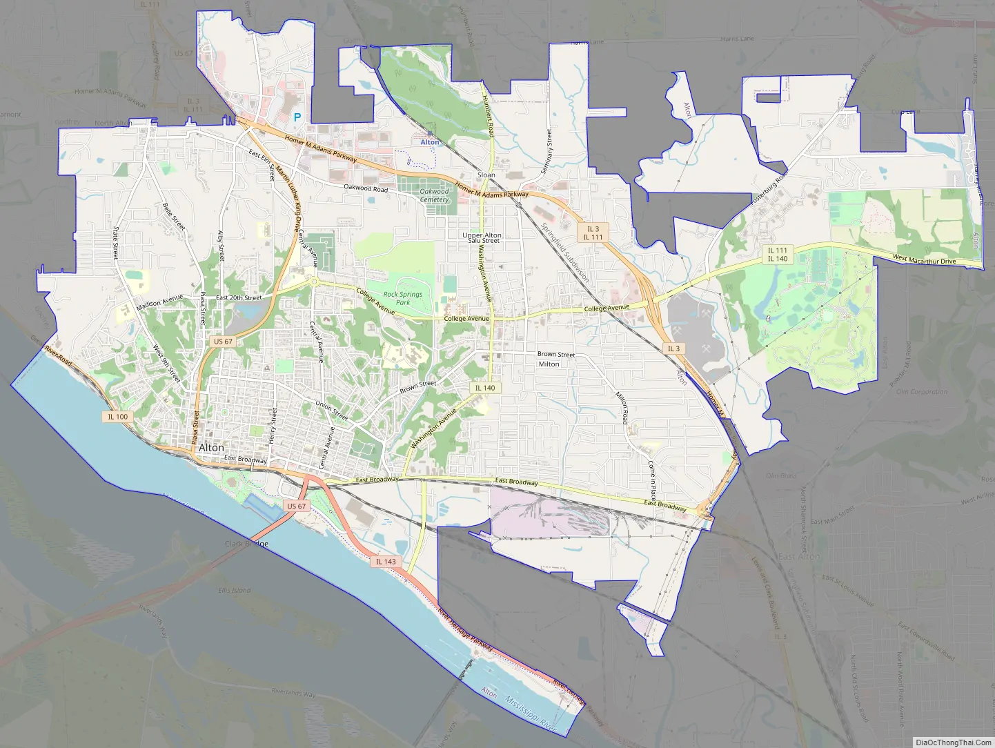
Alton Road Map
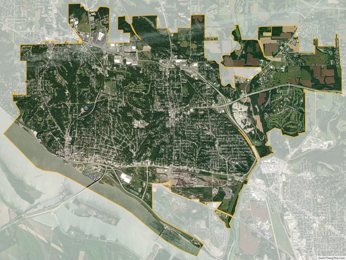
Alton city Satellite Map
Geography
Alton is located on the Mississippi River above the mouth of the Missouri River. Most of Alton is located on bluffs overlooking the river valley. The Meeting of the Great Rivers National Scenic Byway runs along the Alton riverfront. A monument and observatory tower, Confluence Tower, located next to the confluence of the Missouri and Mississippi Rivers in neighboring Hartford, IL, has been constructed to provide an overview of the Great Rivers area. This point also marks the beginning of the famous Lewis and Clark Expedition. Also on the river at Alton is Lock and Dam 26, the newest and busiest lock and dam complex on the main channel of the Mississippi River. Adjacent to it on the Illinois side is the National Great Rivers Museum [Wikidata], which features tours of the dam itself several times per day. On the Missouri side is the Audubon Center at Riverlands, which is one of the best places in the world to view birds, as it lies near where the Mississippi Flyway merges the flight paths of the Mississippi, Illinois and Missouri rivers. Also adjacent to the Audubon Center is the Jones-Confluence Point State Park, where one can stand at the confluence of the Missouri and Mississippi Rivers.
According to the 2010 census, Alton has a total area of 16.736 square miles (43.35 km), of which 15.47 square miles (40.07 km) (or 92.44%) is land and 1.266 square miles (3.28 km) (or 7.56%) is water.
The National Great Rivers Museum is located at the new Lock and Dam No. 26, or Melvin Price Locks and Dam. The lock and dam are open for tours. The lock is a favorite spot to watch bald eagles, which feed on fish coming up in waters below the dam. A large bird sanctuary is located in an area of floodplain and wetlands on the west side of the river.
The River Road goes right next to the river north to Grafton. Above that, it is often routed inland of the floodplain. It provides views of the dramatic contrast between the high cliffs of the Illinois side to the broad, flat, green agricultural countryside of Portage des Sioux, Missouri. The Great River Road is a popular bicycle touring route. Hidden in a notch of the cliff is the tiny village of Elsah, once a down-and-dirty, liquor-soaked tugboaters’ retreat, now with renovated properties and antique shops in historic houses.
Climate
See also
Map of Illinois State and its subdivision:- Adams
- Alexander
- Bond
- Boone
- Brown
- Bureau
- Calhoun
- Carroll
- Cass
- Champaign
- Christian
- Clark
- Clay
- Clinton
- Coles
- Cook
- Crawford
- Cumberland
- De Kalb
- De Witt
- Douglas
- Dupage
- Edgar
- Edwards
- Effingham
- Fayette
- Ford
- Franklin
- Fulton
- Gallatin
- Greene
- Grundy
- Hamilton
- Hancock
- Hardin
- Henderson
- Henry
- Iroquois
- Jackson
- Jasper
- Jefferson
- Jersey
- Jo Daviess
- Johnson
- Kane
- Kankakee
- Kendall
- Knox
- La Salle
- Lake
- Lake Michigan
- Lawrence
- Lee
- Livingston
- Logan
- Macon
- Macoupin
- Madison
- Marion
- Marshall
- Mason
- Massac
- McDonough
- McHenry
- McLean
- Menard
- Mercer
- Monroe
- Montgomery
- Morgan
- Moultrie
- Ogle
- Peoria
- Perry
- Piatt
- Pike
- Pope
- Pulaski
- Putnam
- Randolph
- Richland
- Rock Island
- Saint Clair
- Saline
- Sangamon
- Schuyler
- Scott
- Shelby
- Stark
- Stephenson
- Tazewell
- Union
- Vermilion
- Wabash
- Warren
- Washington
- Wayne
- White
- Whiteside
- Will
- Williamson
- Winnebago
- Woodford
- Alabama
- Alaska
- Arizona
- Arkansas
- California
- Colorado
- Connecticut
- Delaware
- District of Columbia
- Florida
- Georgia
- Hawaii
- Idaho
- Illinois
- Indiana
- Iowa
- Kansas
- Kentucky
- Louisiana
- Maine
- Maryland
- Massachusetts
- Michigan
- Minnesota
- Mississippi
- Missouri
- Montana
- Nebraska
- Nevada
- New Hampshire
- New Jersey
- New Mexico
- New York
- North Carolina
- North Dakota
- Ohio
- Oklahoma
- Oregon
- Pennsylvania
- Rhode Island
- South Carolina
- South Dakota
- Tennessee
- Texas
- Utah
- Vermont
- Virginia
- Washington
- West Virginia
- Wisconsin
- Wyoming


