Pittston is a city in Luzerne County, Pennsylvania, United States. It is situated between Scranton and Wilkes-Barre in Northeastern Pennsylvania. The city gained prominence in the late 19th and early 20th centuries as an active anthracite coal mining city, drawing a large portion of its labor force from European immigrants. The population was 7,739 as of the 2010 census, making it the fourth largest city in Luzerne County.
At its peak in 1920, the population of Pittston was 18,497. The city consists of three sections: The Downtown (in the center of the city), the Oregon Section (in the southern end), and the Junction (in the northern end). Pittston City is at the heart of the Greater Pittston region (a 65.35 square mile region in Luzerne County). Greater Pittston has a total population of 48,020 (as of 2010).
Pittston is 68.7 miles (110.6 km) north of Allentown and 129.2 miles (207.9 km) northwest of New York City.
| Name: | Pittston city |
|---|---|
| LSAD Code: | 25 |
| LSAD Description: | city (suffix) |
| State: | Pennsylvania |
| County: | Luzerne County |
| Elevation: | 653 ft (199 m) |
| Total Area: | 1.71 sq mi (4.44 km²) |
| Land Area: | 1.53 sq mi (3.96 km²) |
| Water Area: | 0.18 sq mi (0.48 km²) |
| Total Population: | 7,591 |
| Population Density: | 4,961.44/sq mi (1,915.03/km²) |
| Area code: | 570 & 272 |
| FIPS code: | 4261048 |
| Website: | www.pittstoncity.org |
Online Interactive Map
Click on ![]() to view map in "full screen" mode.
to view map in "full screen" mode.
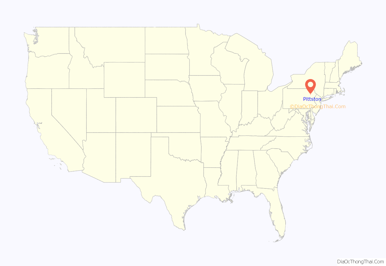
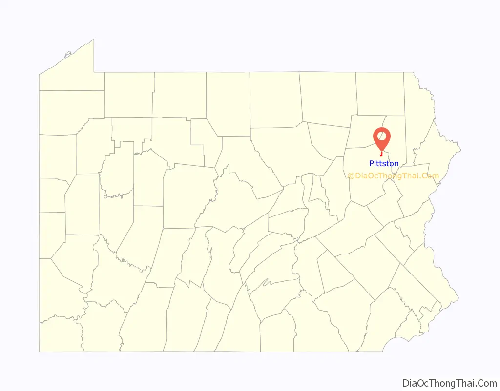
Pittston location map. Where is Pittston city?
History
Establishment
Pittston lies in the Wyoming Valley on the east side of the Susquehanna River and on the south side of the Lackawanna River. It is approximately midway between Wilkes-Barre and Scranton. Named after the famous British statesman William Pitt the Elder, the city was settled around 1770 by the Susquehanna Company of Connecticut. It was originally called “Pittstown.”
During the Revolutionary War, the Wyoming Valley became a battleground between the British and the Americans. On July 3, 1778, a force of British provincial soldiers, with the assistance of about 500 Iroquois, attacked and killed about 300 Patriot soldiers at the Battle of Wyoming.
A company of militia, led by Captain Jeremiah Blanchard and Lieutenant Timothy Keyes, held and maintained a fort in Pittston. The fort was surrendered on July 4, 1778, one day after the Battle of Wyoming, and was later partially burned. In 1780, Pittston Fort was reoccupied, restored and strengthened. From then on it was under Patriot control until the end of the war in 1783, with the signing of the Treaty of Paris. Today a marker stands at the site where the fort once stood.
Pittston broke away from Pittston Township and officially became a borough in 1853. John Hosie served as the first burgess of the Borough of Pittston. It was later chartered as a city on December 10, 1894. Thomas J. Maloney served as the city’s first mayor from 1894 to 1898. Throughout the late 1890s, Pittston’s borders extended from Scranton to Wilkes-Barre, but due to financial and civil differences, the community would soon be divided into the many townships and boroughs that exist throughout the central Wyoming Valley today.
Coal mining
Pittston is located within Pennsylvania’s Coal Region. The first discovery of the anthracite coal (in the Wyoming Valley) occurred around 1770. The first mine was established in 1775 near Pittston. With the opening of a canal in the 1830s, Pittston became an important link in the coal industry. Money made through the mining and transportation of coal led some of the leading merchants to petition its separation from Pittston Township. The anthracite and railroad industry attracted thousands of immigrants, making Pittston a true melting pot with once-distinct ethnic and class neighborhoods. The population of Pittston boomed in the late 19th century. The boom continued well into the 20th century.
The anthracite coal mining industry, and its extensive use of child labor in the early part of the 20th century, was one of the industries targeted by the National Child Labor Committee and its hired photographer, Lewis Hine. Many of Hine’s subjects were photographed in the mines and coal fields in and around Pittston between 1908 and 1912. The impact of the Hine photographs led to the enactment of child labor laws across the country.
Mining disasters
Coal mining remained the prominent industry in Pittston for many decades, but disasters did strike on more than one occasion. The first major tragedy occurred in the Newton Coal Company’s Twin Shaft Mine (near the city’s railroad junction). In the early morning hours of June 28, 1896, ninety miners were at work in the Red Ash Vein of the Newton Coal Company’s Twin Shaft Mine in Pittston. At 3:00 am, the roof quickly caved-in. The concussion from the explosion was so great that it was heard for miles around. The foundation of nearly every building in Pittston was shaken. The cave-in killed 58 miners (including the city’s then-acting mayor, Michael J. Langan).
Anthracite coal mining remained a major industry in the Greater Pittston region until the Knox Mine Disaster. It essentially killed the industry in Northeastern Pennsylvania. On January 22, 1959, the ice-laden Susquehanna River broke through the roof of the River Slope Mine of the Knox Coal Company in nearby Port Griffith (in Jenkins Township). This allowed for billions of gallons of river water to flood the interconnected mines. It took three days to plug the hole in the riverbed, which was done by dumping large railroad cars, smaller mine cars, culm, and other debris into the whirlpool formed by the water draining into the mine.
Sixty-nine miners escaped; twelve miners died and their bodies were never recovered. The heroic efforts of one miner, Myron Thomas of Taylor, led twenty-six miners to safety. Another group of six men was led by Pacifico “Joe” Stella of Pittston. Amedeo Pancotti was part of the second group, and for his remarkable climb out of the Eagle Air Shaft (the only exit available) to the surface, he was awarded the Carnegie Medal for Heroism from the Carnegie Hero Fund Commission.
At 5:15 pm on November 27, 1942, the cave-in of an anthracite mine, that had not been operated since 1868, caused the earth of a half square mile of Pittston to crack and subside.
The largest crack was “…five feet wide, 150 feet long and so deep the bottom was not visible. Two hundred homes were twisted, cracked or sprung from their foundations. Sidewalks were torn up and gas and water mains snapped in several places. Water cascaded through the streets and flooded cellars.”
“Since 1942 the Pennsylvania DEP [Department of Environmental Protection] and its predecessor, Pennsylvania Department of Environmental Resources (PADER), as well as the U.S. Department of the Interior/Office of Surface Mining, Reclamation and Enforcement (OSM), have investigated 149 mine-related subsidence events in the city.”
Boom and bust
Pittston became an active railroad center in response to its mining and industrial activity. The Lehigh Valley Railroad maintained a station in downtown Pittston, near the foot of the Water Street Bridge. The station did not survive the urban renewal of the 1960s and was demolished in 1964. Pittston also had a station on the historic Lackawanna and Wyoming Valley Railroad, commonly known as the Laurel Line.
Besides mining anthracite coal, Pittston was home to many industries in the 19th and 20th centuries, including metals, plastics, paper products, apparel, electrical equipment and beverages. The Pittston Stove Company, established in 1864, manufactured coal and wood-burning stoves for heating and cooking. The Pittston Brewing Company, brewers of Glennon’s Beer, maintained operations in Pittston from 1873 until 1948. Evan R. Jones Stoneware crafted pottery which bore the Pittston name in the 1870s and 1880s.
From the 1930s to the 1980s, Pittston City emerged as a national center for clothing manufacturing. Thousands of workers, mainly women, labored in many factories throughout the Greater Pittston area. Most were members of the International Ladies’ Garment Workers’ Union (ILGWU). They fought for higher wages, workplace health & safety improvements, and employee rights. The ILGWU was active in civic and political life throughout Pennsylvania.
Main Street was the site of an active downtown into the 1970s, with many clothing stores, shoe stores, jewelers, JC Penneys, Kresge’s, Woolworth’s, drug stores, restaurants, theaters and banks. It was home to at least two theaters, the Roman at 27 South Main and the American at 48 North Main, both of which have been razed. Many historic commercial structures were demolished in the urban renewal efforts of the 1960s. By the late 20th century, most of the city’s factories were closed and shipped overseas. Over time, stores throughout the downtown were also closed and boarded up. Pittston, like most cities in the rust belt, witnessed population loss and urban decay.
Contemporary era
On March 15, 1993, two Pittston firefighters (John Lombardo and Len Insalaco) were killed while fighting a blaze on the city’s main street. A monument was built in the downtown and the nearby Water Street Bridge was renamed to commemorate their sacrifice during that tragic March day.
For decades, the towering spires of the many Protestant and Roman Catholic churches dominated the city’s skyline. Most of the numerous Catholic churches were established to serve one of the many ethnic communities that made up Pittston. The Irish had St. John the Evangelist and St. Mary Help of Christians, the Slovaks had St. John the Baptist, the Lithuanians had St. Casimir’s, the Germans had St. Mary Assumption, and the Italians had St. Rocco’s and Our Lady of Mount Carmel. There is also a Carpatho-Rusyn Byzantine Catholic Church on Main Street (St. Michael’s). From 2004 to the present, the Diocese of Scranton has closed many of the churches and private schools in and around Pittston due to declining population and enrollment. Saint John the Baptist Elementary School closed in 2004, and Seton Catholic High School closed in 2007. St. Mary’s Assumption School closed in 2011.
In 2009, Mayor Joseph P. Keating resigned after losing his bid for re-nomination. The city council appointed the first female mayor in the city’s history (Donna McFadden-Connors) to serve out the remainder of Keating’s term. She was later succeeded in 2010 by the youngest mayor in the city’s history (Jason C. Klush).
Pittston City is currently undergoing an economic revitalization since the start of its industrial decline decades ago. In recent years, the downtown area was renovated with new sidewalks, trees, and street lights. Older buildings are being demolished and newer structures (i.e., condominiums, restaurants, bars, and stores) are being built.
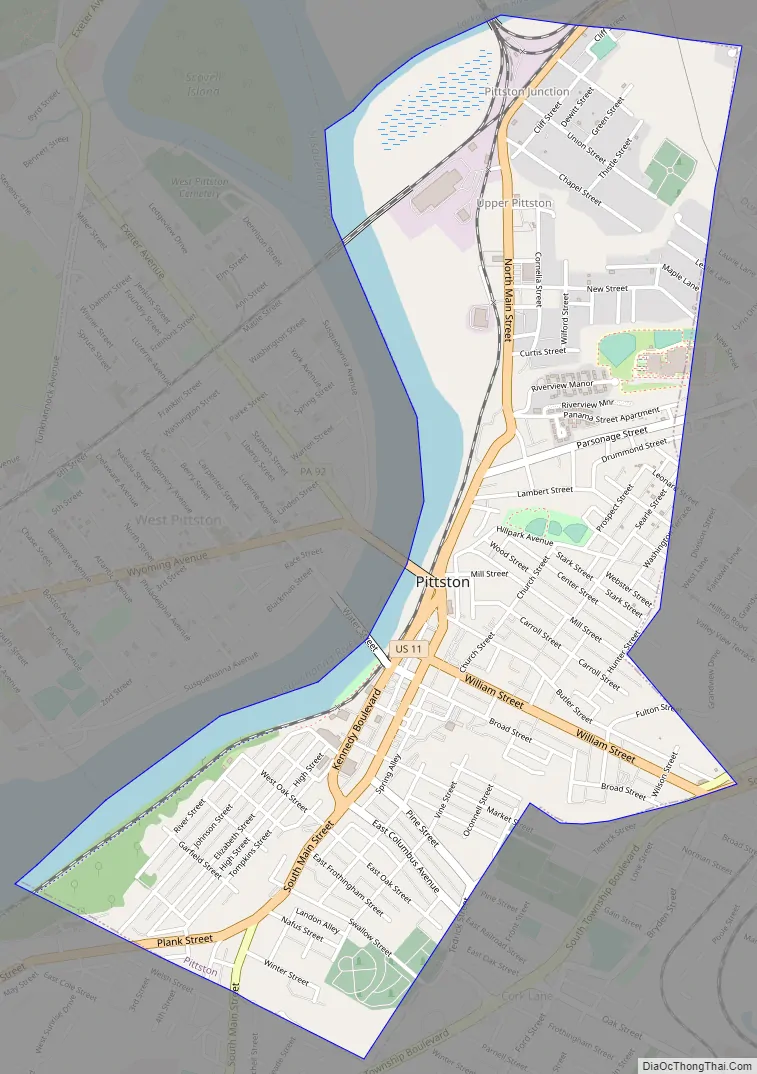
Pittston Road Map
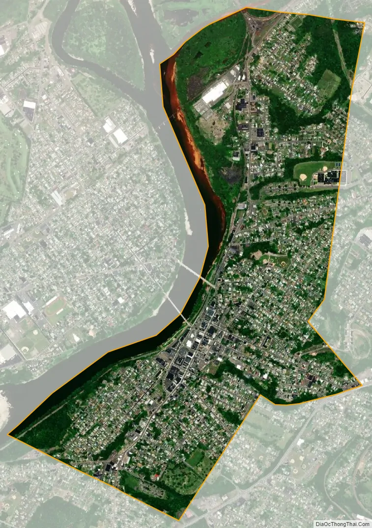
Pittston city Satellite Map
Geography
The City of Pittston lies in the Wyoming Valley on the east side of the Susquehanna River and on the south side of the Lackawanna River. It is approximately midway between Wilkes-Barre and Scranton. According to the United States Census Bureau, the city has a total area of 1.7 square miles (4.4 km), of which 1.6 square miles (4.1 km) is land and 0.1 square miles (0.26 km), or 8.09%, is water.
The city can be divided into three sections: the Oregon Section (located in southern Pittston), the Downtown (or City Center), and the Junction (or Upper Pittston). The Oregon Section is a neighborhood located on high ground overlooking the Susquehanna River (in the southern half of the city). The Downtown is located to the north (in the central part of Pittston). U.S. Route 11 passes through this part of the city. Two bridges cross over the Susquehanna and connect the Downtown with the Borough of West Pittston (on the opposite bank). The Downtown is where most of the city’s businesses and high-rises exist. The elevation climbs as you move inland (eastward) away from the Susquehanna. The northernmost section of the city is known as the Junction. It is named after the railroad junction (or the Duryea Yard) which runs through its borders. It consists mostly of suburbs built upon several steep hills which overlook both the Susquehanna and Lackawanna Rivers. The Lackawanna River makes up Pittston’s northern border.
The area in and around Pittston is referred to as Greater Pittston and includes Avoca, Dupont, Duryea, Exeter, Exeter Township, Hughestown, Jenkins Township, Laflin, Pittston, Pittston Township, West Pittston, West Wyoming, Wyoming, and Yatesville.
Pittston has a hot-summer humid continental climate (Dfa) and average monthly temperatures range from 26.9 °F (−2.8 °C) in January to 72.4 °F (22.4 °C) in July. PRISM Climate Group at Oregon State University The hardiness zone is 6b.
See also
Map of Pennsylvania State and its subdivision:- Adams
- Allegheny
- Armstrong
- Beaver
- Bedford
- Berks
- Blair
- Bradford
- Bucks
- Butler
- Cambria
- Cameron
- Carbon
- Centre
- Chester
- Clarion
- Clearfield
- Clinton
- Columbia
- Crawford
- Cumberland
- Dauphin
- Delaware
- Elk
- Erie
- Fayette
- Forest
- Franklin
- Fulton
- Greene
- Huntingdon
- Indiana
- Jefferson
- Juniata
- Lackawanna
- Lancaster
- Lawrence
- Lebanon
- Lehigh
- Luzerne
- Lycoming
- Mc Kean
- Mercer
- Mifflin
- Monroe
- Montgomery
- Montour
- Northampton
- Northumberland
- Perry
- Philadelphia
- Pike
- Potter
- Schuylkill
- Snyder
- Somerset
- Sullivan
- Susquehanna
- Tioga
- Union
- Venango
- Warren
- Washington
- Wayne
- Westmoreland
- Wyoming
- York
- Alabama
- Alaska
- Arizona
- Arkansas
- California
- Colorado
- Connecticut
- Delaware
- District of Columbia
- Florida
- Georgia
- Hawaii
- Idaho
- Illinois
- Indiana
- Iowa
- Kansas
- Kentucky
- Louisiana
- Maine
- Maryland
- Massachusetts
- Michigan
- Minnesota
- Mississippi
- Missouri
- Montana
- Nebraska
- Nevada
- New Hampshire
- New Jersey
- New Mexico
- New York
- North Carolina
- North Dakota
- Ohio
- Oklahoma
- Oregon
- Pennsylvania
- Rhode Island
- South Carolina
- South Dakota
- Tennessee
- Texas
- Utah
- Vermont
- Virginia
- Washington
- West Virginia
- Wisconsin
- Wyoming


