| Name: | Birmingham city |
|---|---|
| LSAD Code: | 25 |
| LSAD Description: | city (suffix) |
| State: | Alabama |
| County: | Jefferson County, Shelby County |
| Incorporated: | December 19, 1871 |
| Elevation: | 597 ft (182 m) |
| Land Area: | 147.02 sq mi (380.77 km²) |
| Water Area: | 2.52 sq mi (6.53 km²) |
| Population Density: | 1,365.37/sq mi (527.17/km²) |
| Area code: | 205, 659 |
| FIPS code: | 0107000 |
| GNISfeature ID: | 2403868 |
| Website: | www.birminghamal.gov |
Discover the beauty of Birmingham Alabama with this interactive map of Birmingham. Explore the city’s attractions, restaurants, and hotels, and find the perfect spot for your next visit. From historical sites to outdoor activities, there’s something for everyone in Birmingham.
Explore the best of what Birmingham has to offer with this interactive map of Birmingham. From historical sites to outdoor activities, there’s something for everyone in the city. Find the perfect spot for your next visit with this map, which highlights local attractions, restaurants, and hotels.
Online Interactive Map
Click on ![]() to view map in "full screen" mode.
to view map in "full screen" mode.
The Birmingham interactive map is a popular tool that helps visitors get around the city and find what they are looking for with ease. The map features a variety of amenities such as restaurants, shopping centers, parks, and more. Whether you are visiting or living in Birmingham, this interactive map is a great way to find things to do and help you navigate your new city!
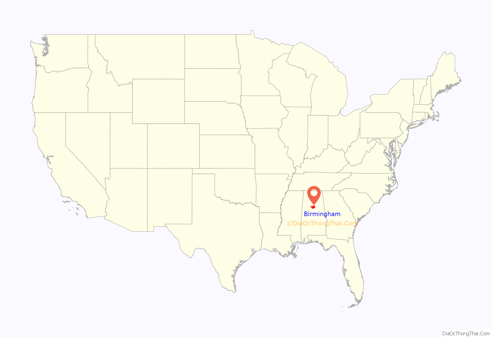
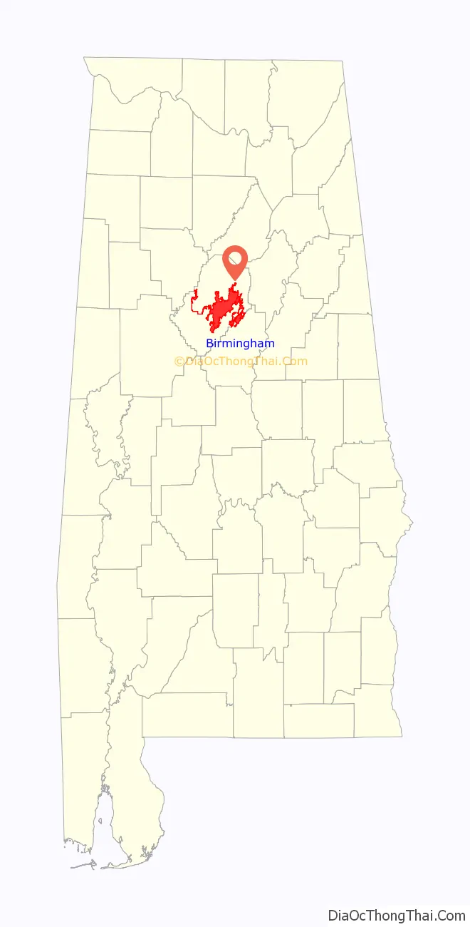
Birmingham location map. Where is Birmingham city?
History
Founding and early growth
Birmingham was founded on June 1, 1871, by the Elyton Land Company whose investors included cotton planters, bankers and railroad entrepreneurs. It sold lots near the planned crossing of the Alabama & Chattanooga and South & North Alabama railroads, including land formerly a part of the Benjamin P. Worthington plantation. The first business at that crossroads was the trading post and country store operated by Marre & Allen. The site of the railroad crossing was notable for the nearby deposits of iron ore, coal, and limestone – the three main raw materials used in making steel.
Birmingham is the only place worldwide where significant amounts of all three minerals can be found in close proximity. From the start the new city was planned as a great center of industry. The founders, organized as the Elyton Land Company, borrowed the name of Birmingham, one of England’s main industrial cities, to advertise that point. The growth of the planned city was impeded by an outbreak of cholera and a Wall Street crash in 1873. However, it began to develop shortly afterward at an explosive rate.
The town of Elyton, Alabama, and several other surrounding towns were absorbed into Birmingham in 1911. The start of the 20th century brought the substantial growth that gave Birmingham the nickname “The Magic City”, as the downtown area developed from a low-rise commercial and residential district into a busy grid of neoclassical mid-rise and high-rise buildings and busy streetcar lines. Between 1902 and 1912 four large office buildings were constructed at the intersection of 20th Street, the central north–south spine of the city, and 1st Avenue North, which connected the warehouses and industrial facilities stretching along the east–west railroad corridor. This impressive group of early skyscrapers was nicknamed “The Heaviest Corner on Earth”.
Birmingham was hit by the 1916 Irondale earthquake (magnitude 5.1). A few buildings in the area were slightly damaged. The earthquake was felt as far as Atlanta and neighboring states.
While excluded from the best-paying industrial jobs, blacks joined the migration of residents from rural areas to the city for its opportunities. The Great Depression of the 1930s hit Birmingham especially hard as sources of capital that were fueling the city’s growth rapidly dried up at the same time that farm laborers, driven off the land, made their way to the city in search of work. New Deal programs put many city residents to work in WPA and CCC programs, making important contributions to the city’s infrastructure and artistic legacy, including such key improvements as Vulcan’s tower and Oak Mountain State Park.
The wartime demand for steel and the post-war building boom gave Birmingham a rapid return to prosperity. Manufacturing diversified beyond the production of raw materials. Major civic institutions such as schools, parks and museums, were able to expand their scope.
Despite the growing population and wealth of the city, its residents were markedly underrepresented in the state legislature. Although the state constitution required redistricting in accordance with changes in the decennial census, the state legislature did not undertake this until the early 1970s, when forced by a federal court case to enforce “one man, one vote”. In addition, the geographic basis of the senate, which gave each county one seat, gave undue influence to rural counties. Representatives of rural counties also had disproportionate power in the state house, and failed to provide support for infrastructure and other improvements in developing urban population centers such as Birmingham. At this time, the General Assembly ran county governments as extensions of the state through their legislative delegations.
Birmingham civil rights movement
In the 1950s and 1960s Birmingham received national and international attention as a center of the civil rights struggle for African-Americans. Locally the movement’s activists were led by Fred Shuttlesworth, a fiery preacher who became legendary for his fearlessness in the face of violence, notably a string of racially motivated bombings that earned Birmingham the derisive nickname “Bombingham”.
A watershed in the civil rights movement occurred in 1963 when Shuttlesworth requested that Martin Luther King Jr., and the Southern Christian Leadership Conference (SCLC), which Shuttlesworth had co-founded, come to Birmingham, where King had once been a pastor, to help end segregation. Together they launched “Project C” (for “Confrontation”), a massive assault on the Jim Crow system. During April and May daily sit-ins and mass marches organized and led by movement leader James Bevel were met with police repression, tear gas, attack dogs, fire hoses, and arrests. More than 3,000 people were arrested during these protests, almost all of them high-school age children. These protests were ultimately successful, leading not only to desegregation of public accommodations in Birmingham but also the Civil Rights Act of 1964.
While imprisoned for having taken part in a nonviolent protest, Dr. King wrote the now famous Letter from Birmingham Jail, a defining treatise in his cause against segregation. Birmingham is also known for a bombing which occurred later that year, in which four black girls were killed by a bomb planted at the 16th Street Baptist Church. The event would inspire the African-American poet Dudley Randall’s opus, “The Ballad of Birmingham”, as well as jazz musician John Coltrane’s song “Alabama”.
In 1998 the Birmingham Pledge, written by local attorney James Rotch, was introduced at the Martin Luther King Unity Breakfast. As a grassroots community commitment to combating racism and prejudice, it has since then been used for programs in all fifty states and in more than twenty countries.
Recent history
In the 1970s, urban-renewal efforts focused around the development of the University of Alabama at Birmingham, which developed into a major medical and research center. In 1971, Birmingham celebrated its centennial with a round of public-works improvements, including an upgrade of Vulcan Park and the construction of a major downtown convention center containing a 2,500-seat symphony hall, theater, 19,000-seat arena, and exhibition halls. Birmingham’s banking institutions enjoyed considerable growth as well and new skyscrapers started to appear in the city center for the first time since the 1920s. These projects helped diversify the city’s economy but did not prevent the exodus of many of the city’s residents to nearby independent suburbs. In 1979, Birmingham elected Dr. Richard Arrington Jr. as its first African-American mayor.
The population inside Birmingham’s city limits has fallen over the past few decades, due in large part to “white flight” from the city of Birmingham proper to surrounding suburbs. The city’s formerly most populous ethnic group, non-Hispanic white, has declined from 57.4 percent in 1970 to 21.1 percent in 2010. From 340,887 in 1960, the population was down to 242,820 in 2000, a loss of about 29 percent. By 2009 Census estimates placed Birmingham’s population at 230,650. That same period saw a corresponding rise in the populations of the suburban communities of Hoover, Vestavia Hills, Alabaster, and Gardendale, none of which were incorporated as municipalities until after 1950.
Today, Birmingham has begun to experience something of a rebirth. New resources have been dedicated to reconstructing the downtown area into a 24-hour, mixed-use district. The market for downtown lofts and condominiums has increased, while restaurant, retail and cultural options are also beginning to expand. In 2006, the city’s visitors bureau selected “the diverse city” as a new tag line for the city. In 2011, the Highland Park neighborhood of Birmingham was named as a 2011 America’s Great Place by the American Planning Association. In 2015, the International World Game Executive Committee selected Birmingham over Lima, Peru and Ufa, Russia, for the 2021 World Games, but the event was delayed a year due to the COVID-19 pandemic. Even with this resurgence, by the 2020 census Birmingham had lost its long-standing status as Alabama’s largest city with Huntsville overtaking Birmingham in total population, though Birmingham remains the state’s largest metropolitan area. Birmingham hosted the 2022 World Games in July 2022.
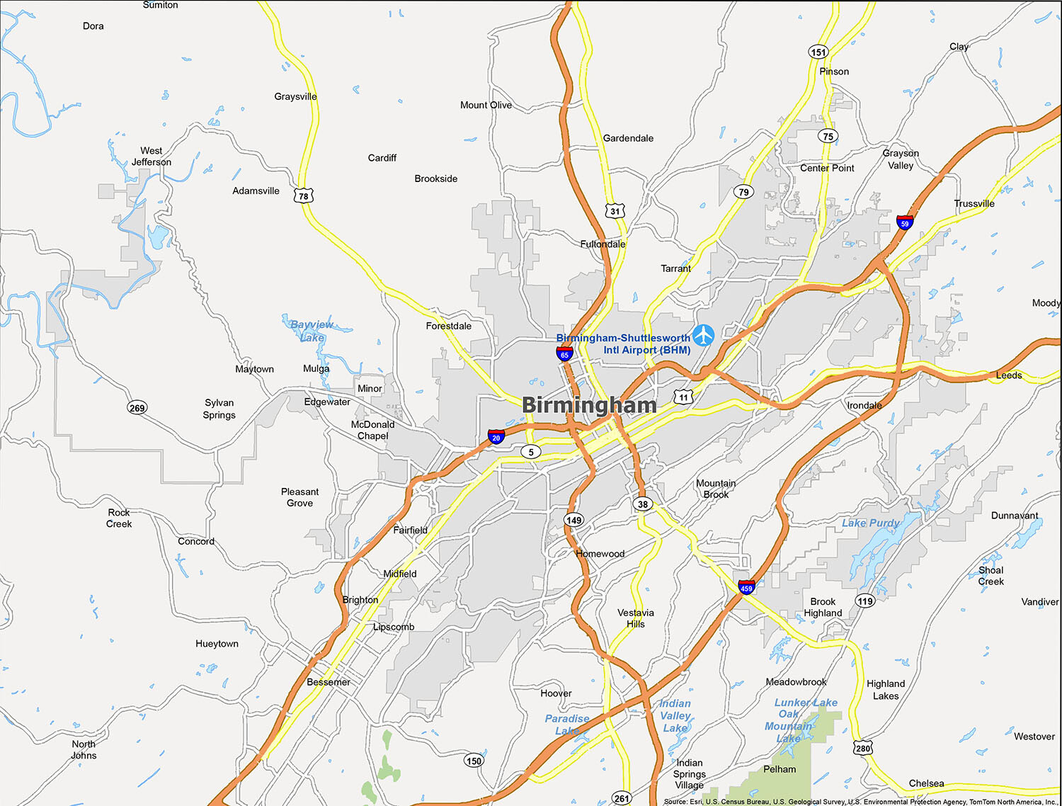
Birmingham Road Map
If you’ve never been to Birmingham, Alabama, this map is a must-have for anyone wanting to discover all the city has to offer. This detailed map of the city will give you all the important information you need, including major highways, the downtown area, and several parks. I-20 and I-65 provide access to Birmingham, Alabama. With this map, you’ll get a bird’s eye view of the interstates, highways, and major roads throughout the state.
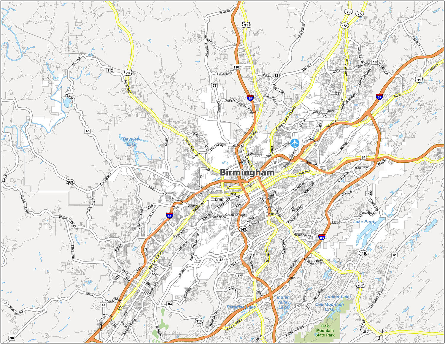
Birmingham is a city with a long and fascinating history. Founded in 1871, it was named after Birmingham, England, and has since grown to a population of over 200,000. The city is renowned for its diverse and vibrant arts and entertainment communities, making it a cultural hub in the South. This map provides a detailed layout and map of Birmingham, as well as other nearby cities, towns, and Census-Designated Places (CDP). Birmingham-Shuttlesworth International Airport (BMH) is also featured on this map.
10 things to do in Birmingham city
If you’re headed to the vibrant city of Birmingham, you’ll find a myriad of attractions to entertain and delight. From the iconic Birmingham Civil Rights Institute to the exciting Barber Motorsports Park, there is something for everyone. For a more relaxed experience, take a stroll through Red Mountain Park or the Birmingham Botanical Gardens. There is also the Negro Southern League Museum, McWane Science Center and the Alabama Jazz Hall of Fame. With a bit of exploration and a map in hand, you can easily find your way around the city and enjoy all that Birmingham has to offer.
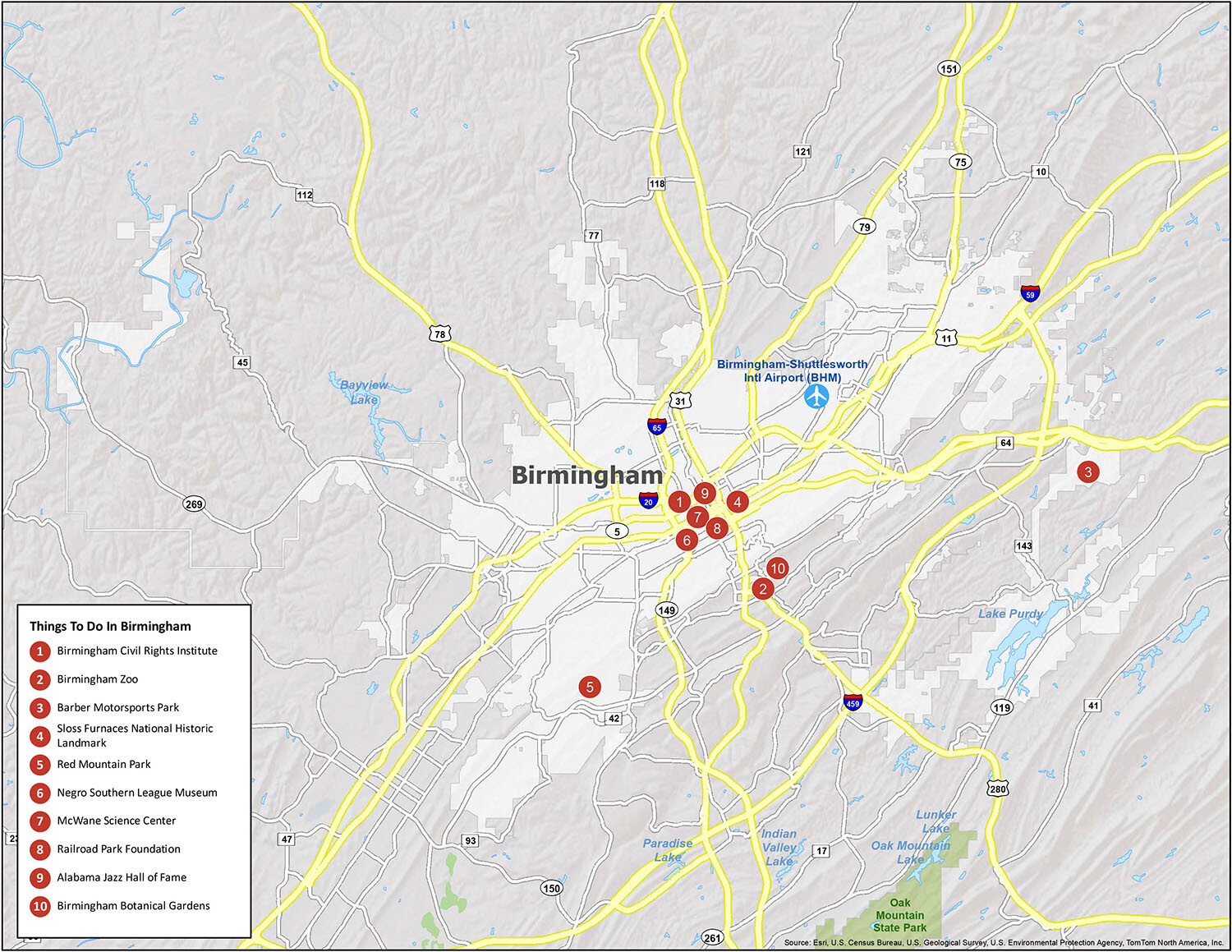
Explore the city of Birmingham and discover the many attractions it has to offer. With its vibrant culture, delicious cuisine and rich history, Birmingham is sure to offer something for everyone. Whether you’re looking for a fun day out or a relaxing stroll through the city, there is something for everyone. Get your map and head out to explore the city of Birmingham today!
Discover the many attractions that Birmingham has to offer! From the iconic Birmingham Civil Rights Institute to the exciting Barber Motorsports Park, there is something for everyone to enjoy. For a more relaxed experience, take a stroll through Red Mountain Park or the Birmingham Botanical Gardens. There is also the Negro Southern League Museum, McWane Science Center and the Alabama Jazz Hall of Fame. With a bit of exploration and a map in hand, you can easily find your way around the city and enjoy all that Birmingham has to offer.
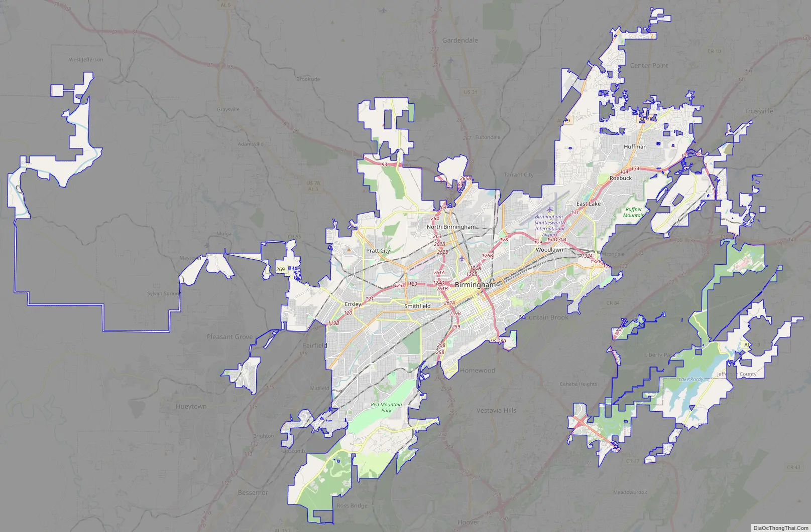
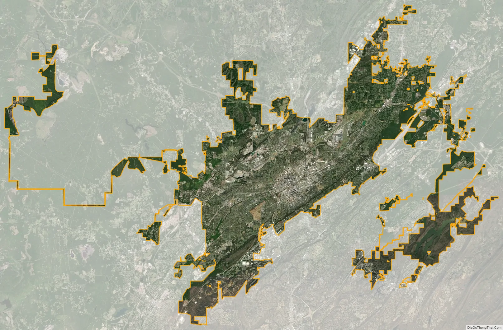
Birmingham city Satellite Map
Geography
Geography
Birmingham occupies Jones Valley, flanked by long parallel mountain ridges (the tailing ends of the Appalachian foothills – see Ridge-and-Valley Appalachians) running from north-east to south-west. The valley is drained by small creeks (Village Creek, Valley Creek) which flow into the Black Warrior River. The valley was bisected by the principal railroad corridor, along which most of the early manufacturing operations began.
Red Mountain lies immediately south of downtown. Many of Birmingham’s television and radio broadcast towers are lined up along this prominent ridge. The “Over the Mountain” area, including Shades Valley, Shades Mountain and beyond, was largely shielded from the industrial smoke and rough streets of the industrial city. This is the setting for Birmingham’s more affluent suburbs of Mountain Brook, Vestavia Hills, Homewood, and Hoover. South of Shades Valley is the Cahaba River basin, one of the most diverse river ecosystems in the United States.
Sand Mountain, a smaller ridge, flanks the city to the north and divides Jones Valley from much more rugged land to the north. The Louisville and Nashville Railroad (now CSX Transportation) enters the valley through Boyles Gap, a prominent gap in the long low ridge.
Ruffner Mountain, located due east of the heart of the city, is home to Ruffner Mountain Nature Center, one of the largest urban nature reserves in the United States.
According to the U.S. Census Bureau, the city has a total area of 151.9 square miles (393 km), of which, 149.9 square miles (388 km) is land and 2.0 square miles (5.2 km) (1.34%) is water.
Surrounding suburbs
Birmingham has an abundance of suburbs. Most of the metropolitan area lives outside of the city itself. In 2007, the metropolitan area was made up of 7 counties, 102 cities, and 21 school districts. Since then Alabaster and Pelham have broken away from the Shelby County School System to form their own school systems. Some argue that the region suffers from having so many suburbs because companies can receive large incentives to move a short distance to another city, with no net gain in the area’s economy.
Birmingham suburbs (in order of population, 2020 US Census):
- Hoover: Pop. 92,606
- Vestavia Hills: Pop. 39,102
- Alabaster: Pop. 33,284
- Bessemer: Pop. 26,019
- Homewood: Pop. 26,414
- Pelham: Pop. 24,318
- Trussville: Pop. 26,123
- Mountain Brook: Pop. 22,461
- Helena: Pop. 19,657
- Center Point: Pop. 16,406
- Tarrant City, Pop. 6,124
- Midfield, Pop. 5,211
- Hueytown: Pop. 16,776
- Talladega: Pop. 15,861
- Cullman: Pop. 18,213
- Jasper: Pop. 14,572
- Gardendale: Pop. 16,044
- Calera: Pop. 12,756
- Sylacauga: Pop. 12,578
- Moody: Pop. 13,170
- Irondale: Pop. 13,497
- Leeds: Pop. 12,324
- Chelsea: Pop. 14,982
- Fairfield: Pop. 10,000
- Pleasant Grove: Pop. 9,544
- Forestdale: Pop. 10,409
- Clay: Pop. 10,291
- Fultondale: Pop. 9,876
- Clanton: Pop. 8,768
- Pinson: Pop. 7,215
- Oneonta: Pop. 6,938
- Montevallo: Pop. 7,229
Cityscape
Climate
Birmingham has a humid subtropical climate, characterized by hot summers, mild winters, and abundant rainfall. January has a daily mean temperature of 43.8 °F (6.6 °C), and there is an average of 47 days annually with a low at or below freezing, and 1.4 where the high does not surpass freezing. July has a daily mean temperature of 81.1 °F (27.3 °C); highs reach or exceed 90 °F (32 °C) on 65 days per year and 100 °F (38 °C) on 2. Precipitation is relatively well-distributed throughout the year, sometimes falling in the form of snow during winter; however, 10.3 inches (26.2 cm) fell on March 13, 1993, during the 1993 Storm of the Century, which established the highest daily snowfall, one-storm, and winter season total on record. Normal snowfall for 1981–2010 is 1.6 in (4.1 cm), but, for the same period, median monthly snowfall for each month was zero.
The summer months are hot, with high humidity. Most of the precipitation that falls in the summer are from thunderstorms, most of which occur in the afternoon and evening hours.
The spring and fall months are pleasant but variable as cold fronts frequently bring strong to severe thunderstorms and occasional tornadoes to the region. The fall season (primarily October) features less rainfall and fewer storms, as well as lower humidity than the spring, but November and early December represent a secondary severe weather season. Birmingham is located on the heart of a Tornado Alley known as the Dixie Alley due to the high frequency of tornadoes in Central Alabama. The greater Birmingham area has been hit by two F5 tornadoes; one in Birmingham’s northern suburbs in 1977, and second in the western suburbs in 1998. The area was hit by an EF4 tornado which was part of a larger outbreak in April 2011. In late summer and fall months, Birmingham experiences occasional tropical storms and hurricanes due to its proximity to the Central Gulf Coast.
The record high temperature is 107 °F (42 °C), set on July 29, 1930, and the record low is −10 °F (−23 °C), set on February 13, 1899.
Earthquakes
The Birmingham area is not prone to frequent earthquakes; its historical activity level is 59% less than the US average. Earthquakes are generally minor and the Birmingham area can feel an earthquake from the Eastern Tennessee Seismic Zone. The magnitude 5.1 Irondale earthquake in 1916 caused damage in the Birmingham area and was felt in the neighboring states and as far as the Carolinas. The 2003 Alabama earthquake centered in northeastern Alabama (magnitude 4.6–4.9) was also felt in Birmingham, Atlanta, Tennessee, Kentucky, and both Carolina states.
See also
Map of Alabama State and its subdivision:- Autauga
- Baldwin
- Barbour
- Bibb
- Blount
- Bullock
- Butler
- Calhoun
- Chambers
- Cherokee
- Chilton
- Choctaw
- Clarke
- Clay
- Cleburne
- Coffee
- Colbert
- Conecuh
- Coosa
- Covington
- Crenshaw
- Cullman
- Dale
- Dallas
- De Kalb
- Elmore
- Escambia
- Etowah
- Fayette
- Franklin
- Geneva
- Greene
- Hale
- Henry
- Houston
- Jackson
- Jefferson
- Lamar
- Lauderdale
- Lawrence
- Lee
- Limestone
- Lowndes
- Macon
- Madison
- Marengo
- Marion
- Marshall
- Mobile
- Monroe
- Montgomery
- Morgan
- Perry
- Pickens
- Pike
- Randolph
- Russell
- Saint Clair
- Shelby
- Sumter
- Talladega
- Tallapoosa
- Tuscaloosa
- Walker
- Washington
- Wilcox
- Winston
- Alabama
- Alaska
- Arizona
- Arkansas
- California
- Colorado
- Connecticut
- Delaware
- District of Columbia
- Florida
- Georgia
- Hawaii
- Idaho
- Illinois
- Indiana
- Iowa
- Kansas
- Kentucky
- Louisiana
- Maine
- Maryland
- Massachusetts
- Michigan
- Minnesota
- Mississippi
- Missouri
- Montana
- Nebraska
- Nevada
- New Hampshire
- New Jersey
- New Mexico
- New York
- North Carolina
- North Dakota
- Ohio
- Oklahoma
- Oregon
- Pennsylvania
- Rhode Island
- South Carolina
- South Dakota
- Tennessee
- Texas
- Utah
- Vermont
- Virginia
- Washington
- West Virginia
- Wisconsin
- Wyoming


