The City of South Fulton is in Fulton County, Georgia, United States, in the Atlanta metropolitan area. It was incorporated in 2017 from parts of southwest Fulton County and includes the communities of Red Oak, Cooks Crossing, Stonewall, Fife, Ben Hill, Sandtown, Cliftondale, Ono, Cedar Grove, Boat Rock/Dry Pond, Maude, Lester, Enon, Welcome All, Peters Woods, and part of Campbellton. As of 2020, it had a population of 107,436, making it the state’s eighth-largest city in population.
| Name: | South Fulton city |
|---|---|
| LSAD Code: | 25 |
| LSAD Description: | city (suffix) |
| State: | Georgia |
| County: | Fulton County |
| Elevation: | 797 ft (243 m) |
| Total Area: | 86.25 sq mi (223.40 km²) |
| Land Area: | 85.22 sq mi (220.71 km²) |
| Water Area: | 1.04 sq mi (2.69 km²) |
| Total Population: | 107,436 |
| Population Density: | 1,260.75/sq mi (486.78/km²) |
| FIPS code: | 1372122 |
| GNISfeature ID: | 2786574 |
| Website: | cityofsouthfultonga.gov |
Online Interactive Map
Click on ![]() to view map in "full screen" mode.
to view map in "full screen" mode.
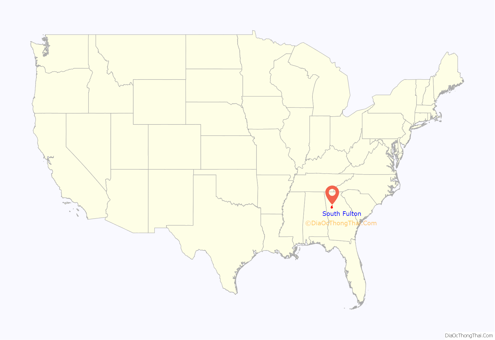
South Fulton location map. Where is South Fulton city?

History
The 2016 Georgia General Assembly passed bill HB514 to incorporate South Fulton. Governor Nathan Deal signed the bill into law on April 29, 2016. On November 8, 59 percent of the citizens of what would become South Fulton voted to charter the city. This referendum was part of a “cityhood movement” in the Atlanta metropolitan area that began in 2005 with the incorporation of Sandy Springs on the north side of Atlanta. Several other communities in Fulton voted to incorporate in 2007. With the passage of the South Fulton referendum in 2016, Fulton County became the first county in Georgia with no unincorporated residential areas. As a result, in 2017 Fulton County also became the first county in Georgia to cease providing municipal services such as fire, police, zoning, and code enforcement. Many former Fulton County personnel and facilities were transferred to the City of South Fulton.
On March 21, 2017, South Fulton held elections for mayor and city council, followed by runoff elections before incorporation took effect on May 1. The first mayor of South Fulton was Bill Edwards, who previously served on the Fulton County Board of Commissioners from 2000 to 2014. His term expired on December 31, 2021.
In November 2017, after a one-year waiting period mandated by state law, the city council selected Renaissance as the new name for the city after allowing residents to suggest names. More than 200 names were submitted, and the list was pared to 20, including Campbellton (a historical town now partly within the city), Atlanta Heights, Wolf Creek and retaining South Fulton. Following a three-week public notice period and two regular public meetings, which are required to amend the city charter, the city council approved the name change in December 2017. However, Mayor Edwards vetoed the name change on December 18, citing several reasons, including contracts and some public opposition.
In its first eight months, South Fulton created its infrastructure, navigated financial challenges and began a transition from Fulton County services.
South Fulton Road Map
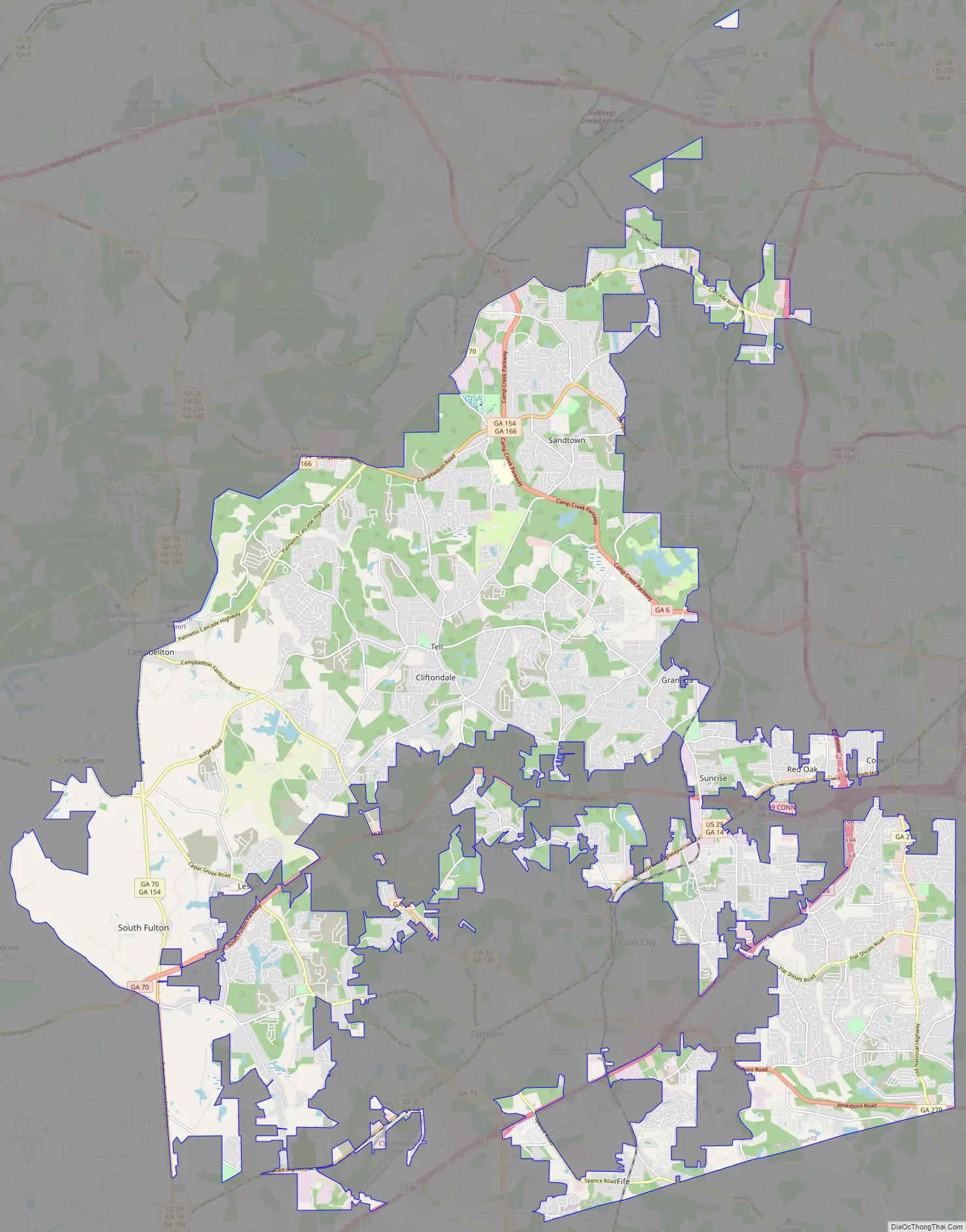
South Fulton city Satellite Map

See also
Map of Georgia State and its subdivision:- Appling
- Atkinson
- Bacon
- Baker
- Baldwin
- Banks
- Barrow
- Bartow
- Ben Hill
- Berrien
- Bibb
- Bleckley
- Brantley
- Brooks
- Bryan
- Bulloch
- Burke
- Butts
- Calhoun
- Camden
- Candler
- Carroll
- Catoosa
- Charlton
- Chatham
- Chattahoochee
- Chattooga
- Cherokee
- Clarke
- Clay
- Clayton
- Clinch
- Cobb
- Coffee
- Colquitt
- Columbia
- Cook
- Coweta
- Crawford
- Crisp
- Dade
- Dawson
- Decatur
- DeKalb
- Dodge
- Dooly
- Dougherty
- Douglas
- Early
- Echols
- Effingham
- Elbert
- Emanuel
- Evans
- Fannin
- Fayette
- Floyd
- Forsyth
- Franklin
- Fulton
- Gilmer
- Glascock
- Glynn
- Gordon
- Grady
- Greene
- Gwinnett
- Habersham
- Hall
- Hancock
- Haralson
- Harris
- Hart
- Heard
- Henry
- Houston
- Irwin
- Jackson
- Jasper
- Jeff Davis
- Jefferson
- Jenkins
- Johnson
- Jones
- Lamar
- Lanier
- Laurens
- Lee
- Liberty
- Lincoln
- Long
- Lowndes
- Lumpkin
- Macon
- Madison
- Marion
- McDuffie
- McIntosh
- Meriwether
- Miller
- Mitchell
- Monroe
- Montgomery
- Morgan
- Murray
- Muscogee
- Newton
- Oconee
- Oglethorpe
- Paulding
- Peach
- Pickens
- Pierce
- Pike
- Polk
- Pulaski
- Putnam
- Quitman
- Rabun
- Randolph
- Richmond
- Rockdale
- Schley
- Screven
- Seminole
- Spalding
- Stephens
- Stewart
- Sumter
- Talbot
- Taliaferro
- Tattnall
- Taylor
- Telfair
- Terrell
- Thomas
- Tift
- Toombs
- Towns
- Treutlen
- Troup
- Turner
- Twiggs
- Union
- Upson
- Walker
- Walton
- Ware
- Warren
- Washington
- Wayne
- Webster
- Wheeler
- White
- Whitfield
- Wilcox
- Wilkes
- Wilkinson
- Worth
- Alabama
- Alaska
- Arizona
- Arkansas
- California
- Colorado
- Connecticut
- Delaware
- District of Columbia
- Florida
- Georgia
- Hawaii
- Idaho
- Illinois
- Indiana
- Iowa
- Kansas
- Kentucky
- Louisiana
- Maine
- Maryland
- Massachusetts
- Michigan
- Minnesota
- Mississippi
- Missouri
- Montana
- Nebraska
- Nevada
- New Hampshire
- New Jersey
- New Mexico
- New York
- North Carolina
- North Dakota
- Ohio
- Oklahoma
- Oregon
- Pennsylvania
- Rhode Island
- South Carolina
- South Dakota
- Tennessee
- Texas
- Utah
- Vermont
- Virginia
- Washington
- West Virginia
- Wisconsin
- Wyoming