The city of Ocilla is the county seat of Irwin County, Georgia, United States. Its population was 3,498 at the 2020 census. Ocilla is part of the Fitzgerald Micropolitan Statistical Area.
| Name: | Ocilla city |
|---|---|
| LSAD Code: | 25 |
| LSAD Description: | city (suffix) |
| State: | Georgia |
| County: | Irwin County |
| Elevation: | 348 ft (106 m) |
| Total Area: | 2.55 sq mi (6.61 km²) |
| Land Area: | 2.54 sq mi (6.59 km²) |
| Water Area: | 0.01 sq mi (0.02 km²) |
| Total Population: | 3,498 |
| Population Density: | 1,374.46/sq mi (530.66/km²) |
| ZIP code: | 31774 |
| Area code: | 229 |
| FIPS code: | 1357428 |
| GNISfeature ID: | 0332555 |
| Website: | www.cityofocillaga.net |
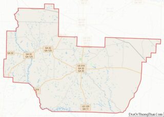
Online Interactive Map
Click on ![]() to view map in "full screen" mode.
to view map in "full screen" mode.
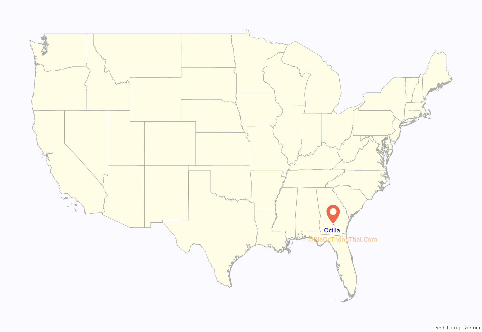
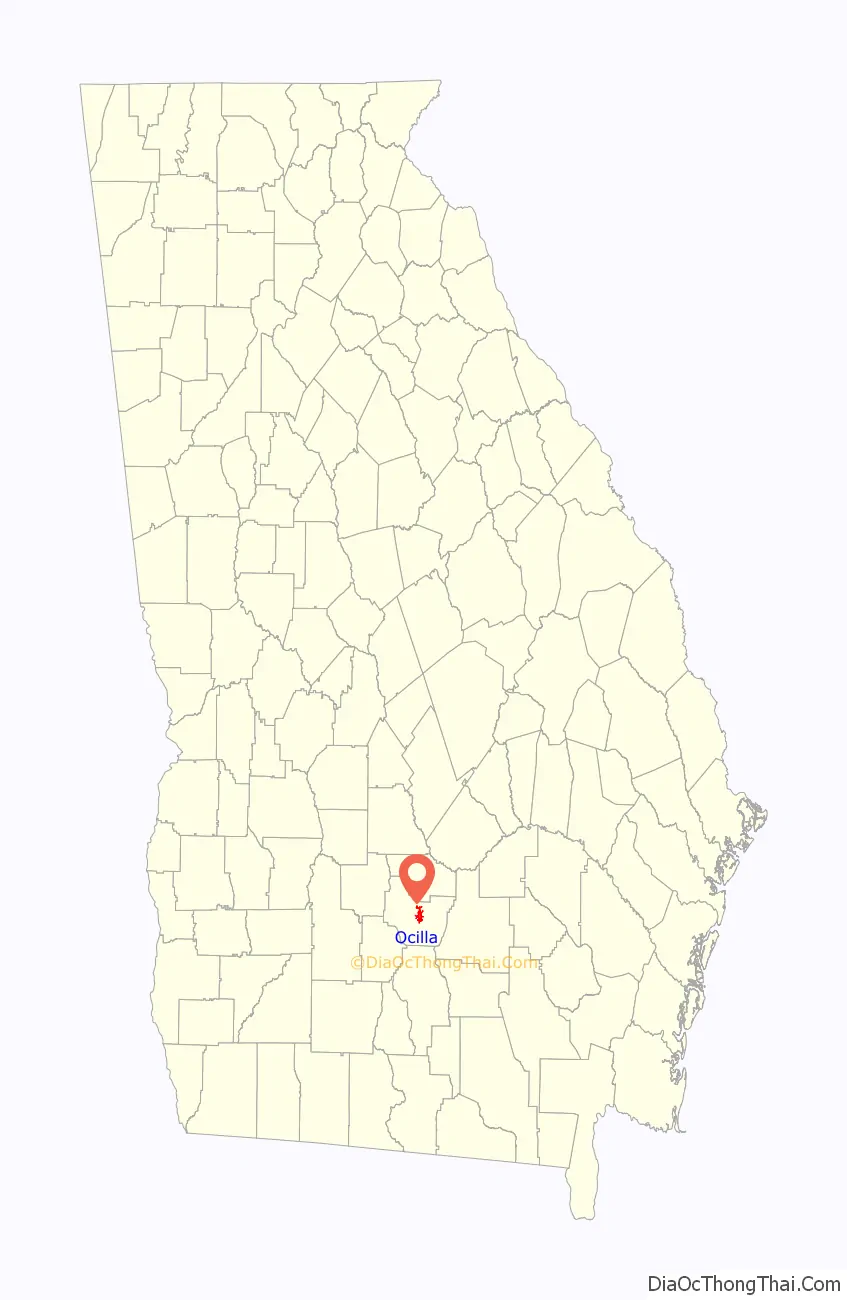
Ocilla location map. Where is Ocilla city?
History
Ocilla was founded in 1880, incorporated as a town in 1897, and finally re-incorporated as a city in 1902. It is not clear whether Ocilla is named for the Seminole Chief Osceola, for an Oswichee Native American tribe, or, as proposed by historian John Goff, it could be an adaptation of the place name Auscilla. A 1981 Fitzgerald Herald-Leader says that “a tribe of Oswichee Indians once lived near the Ocmulgee River on land known in 1818 as Irwin County.” There, towns were called Oswitchee and Ocilla, and sometimes Ocichi. The French census shows that a town called Ocichi existed there in 1750. A later census in 1832 gives Oswhichee as the name of another Indian village close to Osochi.” It goes on with “The town’s name was changed seven times. It was called by the Indians Assile, next Aglie, Axilla, Agulu, Ochile, and lastly Ocilla.” This theory is less popular today.
The most popular theory is that Ocilla is named for Chief Osceola, who had a prominent role in the Second Seminole War. Allegedly, he camped in the area known as Western Heights in Ocilla and frequently could be found in the area until his capture and imprisonment at Fort Moultrie, South Carolina. Osceola is probably the reason that the sports teams in Irwin County are now known as the Indians.
The Christmas Lady of Ocilla
In the 1980s and 1990s Marie Watson was known in Ocilla as the “Christmas Lady.” Watson would intricately decorate the property around her home on Cherry Street with lights and Christmas decorations and each year “Santa Claus” would visit the property, taking wishes for gifts from children. Watson became famous for her Christmas cheer but eventually stopped due to the hassle of decorating and because of her older age. Today, her tradition is somewhat carried on every year as the City of Ocilla now decorates Cumbee Park, the public park directly in front of Watson’s former home, and holds a yearly session with Santa Claus.
Ocilla Raceway or New Veterans Memorial Track
On the outskirts of town, Ocilla once hosted the New Veterans Memorial Track (commonly known as the Ocilla Raceway) which was a 3/8 mile layout racing track. It was inaugurated on April 23, 1950. Governor Herman Talmadge was scheduled to attend but was unavailable and the former Governor M.E. Thompson appeared instead. On opening day 2,500 people watched the first program featuring five separate races. James Bennett of Macon, Georgia won the 20-lap featured race and Lucy Stacks of Fitzgerald won the women’s race. VFW would eventually take over the track after the original owner, Marion “Buddy” Green, decided that its liabilities were too great.
The races eventually began to run from January to December and hosted drivers from as far away as Atlanta and Northern Florida, as well as some local drivers. It was eventually shut down and the track survives in severe disrepair.
Dismuke and Willis Sanitarium
Doctors Dismuke and Willis, the first doctors in Ocilla, built and opened its first hospital, the Dismuke and Willis Sanitarium. The building still stands today across from the old Irwin County High School campus, albeit without its prominent porches. It is now a private residence.
Railroad
The railroad was a prominent factor in the development of Ocilla and Irwin County in the late 19th and early 20th century, with multiple railroads bearing the name of the town. A March 20, 1981 Fitzgerald Herald-Leader article said that at one time, fourteen passenger trains stopped in Ocilla each day. According to Frank Crouch, “The Seaboard passenger trains stopped two times a day,” and there was also a railroad shop where trains would have gone for repair.
While no tracks currently connect any industry or passenger service to Ocilla, the remnants of the “Iron Horses” that once whizzed through the area are still visible from track embankments in Irwinville, Georgia to the historical red caboose prominently overlooking Cumbee Park. There were at least four railroads that connected directly to Ocilla.
The Ocilla and Irwinville Railroad was incorporated on October 4, 1900 or earlier and operated 11 miles of track between Ocilla and Irwinville. The railroad owned one locomotive, one passenger carriage, and 46 freight carriages. The railroad was purchased in 1903 by the Brunswick & Birmingham Railroad, which later leased it to the Fitzgerald, Ocilla, & Broxton Railroad in 1911. The 11 miles of track originally built by the Ocilla & Irwinville Railroad were abandoned in 1916 and later removed.
The Ocilla and Valdosta Railroad was chartered in 1903 with plans to connect Valdosta with Macon. By 1906, the railroad had completed its first line from Broxton to Ocilla and had begun the construction on its line from Ocilla to Fitzgerald. It also purchased a line between Broxton and Hazlehurst in 1905 and had started to absorb the Fitzgerald, Ocmulgee, and Red Bluff Railway. Due to financial issues, it sold the Broxton-Hazlehurst line in 1907. In 1908, its remaining properties became the property of the new Fitzgerald, Ocilla, and Broxton Railroad. Like the Ocilla-Irwinville line, the Broxton-Ocilla line was abandoned in 1916.
The Fitzgerald, Ocilla, and Broxton Railroad was formed in 1907 to take over the failing Ocilla and Valdosta Railroad lines connecting its namesake cities. As it is said above, the railroad also took over the Ocilla-Irwinville route from the Ocilla and Irwinville Railroad by leasing that railroad from its parent owner, the Brunswick & Birmingham Railroad. Like the Ocilla and Valdosta Railroad, the FO&B soon began to fail. It was forced to lease its tracks between Ocilla and Fitzgerald to the Ocilla Southern Railroad in 1911.
The Ocilla Southern Railroad was incorporated in 1908 and opened its Ocilla-Alapaha line in 1910, leased the Ocilla-Fitzgerald line from the FO&B in 1911, built an extension from Fitzgerald to Rochelle in 1914, and extended its line from Rochelle to Pope City in 1917. From Pope City, the Ocilla Southern extended its line to Nashville and owned all of the 69 miles of track between Ocilla and Nashville except for the 10 miles of Ocilla-Fitzgerald line that it was leasing. In 1917, the Ocilla Southern also leased a line between Pope City and Hawkinsville from the Hawkinsville and Florida Southern Railway and the line between Hawkinsville and Perry from the Hawkinsville and Western Railroad. According to the 1923 Poor’s Manual, the Ocilla Southern Railroad wanted to connect Atlanta to Jacksonville, Florida but only ever covered a third of that distance. In 1918, the railroad entered receivership status and by 1923 had begun abandoning most of its lines.
On March 25, 1911, the southbound Dixie Flyer running from Chicago, Illinois to Jacksonville, Florida crashed through a trestle over the Alapaha River, only a short distance from Ocilla. The wreck was found to have been caused by the engine driving wheel axle breaking off. The baggage and express cars, as well as two day coaches, were flung into the water, a steel-construction first class coach car was forced through the sleeper car, the engine stayed on the trestle, and the tender was derailed. Ten people perished as a result, and the line was shut down for 36 hours for all trains. The disaster is considered one of the region’s worst train wrecks in history.
Ocilla Road Map
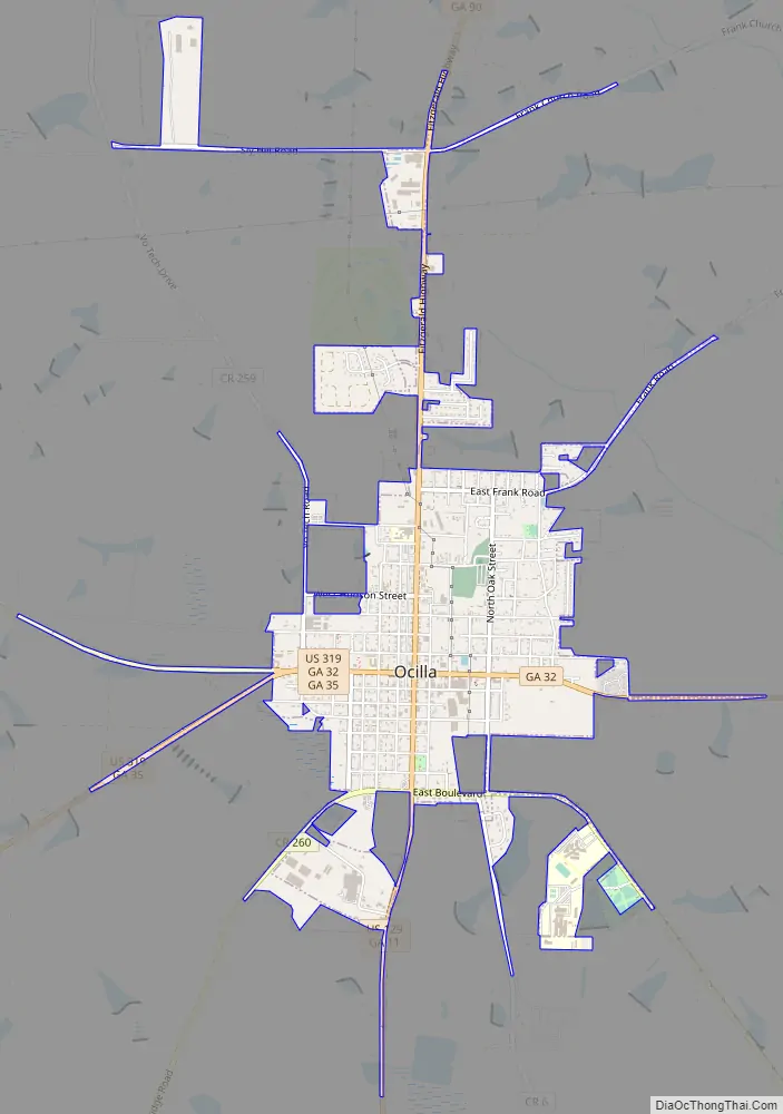
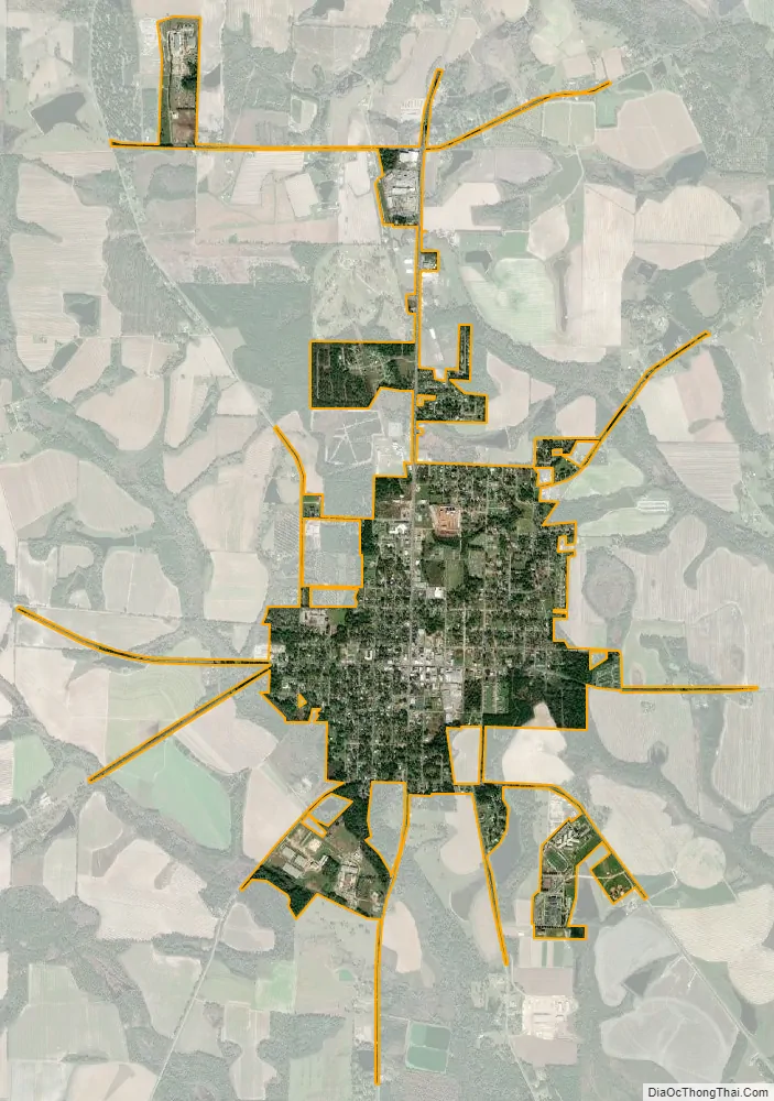
Ocilla city Satellite Map
Geography
Ocilla is located at 31°35′55″N 83°15′0″W / 31.59861°N 83.25000°W / 31.59861; -83.25000 (31.598611, -83.249932).
According to the United States Census Bureau, the city has a total area of 2.6 square miles (6.7 km), of which 2.6 square miles (6.7 km) is land and 0.39% is water.
See also
Map of Georgia State and its subdivision:- Appling
- Atkinson
- Bacon
- Baker
- Baldwin
- Banks
- Barrow
- Bartow
- Ben Hill
- Berrien
- Bibb
- Bleckley
- Brantley
- Brooks
- Bryan
- Bulloch
- Burke
- Butts
- Calhoun
- Camden
- Candler
- Carroll
- Catoosa
- Charlton
- Chatham
- Chattahoochee
- Chattooga
- Cherokee
- Clarke
- Clay
- Clayton
- Clinch
- Cobb
- Coffee
- Colquitt
- Columbia
- Cook
- Coweta
- Crawford
- Crisp
- Dade
- Dawson
- Decatur
- DeKalb
- Dodge
- Dooly
- Dougherty
- Douglas
- Early
- Echols
- Effingham
- Elbert
- Emanuel
- Evans
- Fannin
- Fayette
- Floyd
- Forsyth
- Franklin
- Fulton
- Gilmer
- Glascock
- Glynn
- Gordon
- Grady
- Greene
- Gwinnett
- Habersham
- Hall
- Hancock
- Haralson
- Harris
- Hart
- Heard
- Henry
- Houston
- Irwin
- Jackson
- Jasper
- Jeff Davis
- Jefferson
- Jenkins
- Johnson
- Jones
- Lamar
- Lanier
- Laurens
- Lee
- Liberty
- Lincoln
- Long
- Lowndes
- Lumpkin
- Macon
- Madison
- Marion
- McDuffie
- McIntosh
- Meriwether
- Miller
- Mitchell
- Monroe
- Montgomery
- Morgan
- Murray
- Muscogee
- Newton
- Oconee
- Oglethorpe
- Paulding
- Peach
- Pickens
- Pierce
- Pike
- Polk
- Pulaski
- Putnam
- Quitman
- Rabun
- Randolph
- Richmond
- Rockdale
- Schley
- Screven
- Seminole
- Spalding
- Stephens
- Stewart
- Sumter
- Talbot
- Taliaferro
- Tattnall
- Taylor
- Telfair
- Terrell
- Thomas
- Tift
- Toombs
- Towns
- Treutlen
- Troup
- Turner
- Twiggs
- Union
- Upson
- Walker
- Walton
- Ware
- Warren
- Washington
- Wayne
- Webster
- Wheeler
- White
- Whitfield
- Wilcox
- Wilkes
- Wilkinson
- Worth
- Alabama
- Alaska
- Arizona
- Arkansas
- California
- Colorado
- Connecticut
- Delaware
- District of Columbia
- Florida
- Georgia
- Hawaii
- Idaho
- Illinois
- Indiana
- Iowa
- Kansas
- Kentucky
- Louisiana
- Maine
- Maryland
- Massachusetts
- Michigan
- Minnesota
- Mississippi
- Missouri
- Montana
- Nebraska
- Nevada
- New Hampshire
- New Jersey
- New Mexico
- New York
- North Carolina
- North Dakota
- Ohio
- Oklahoma
- Oregon
- Pennsylvania
- Rhode Island
- South Carolina
- South Dakota
- Tennessee
- Texas
- Utah
- Vermont
- Virginia
- Washington
- West Virginia
- Wisconsin
- Wyoming