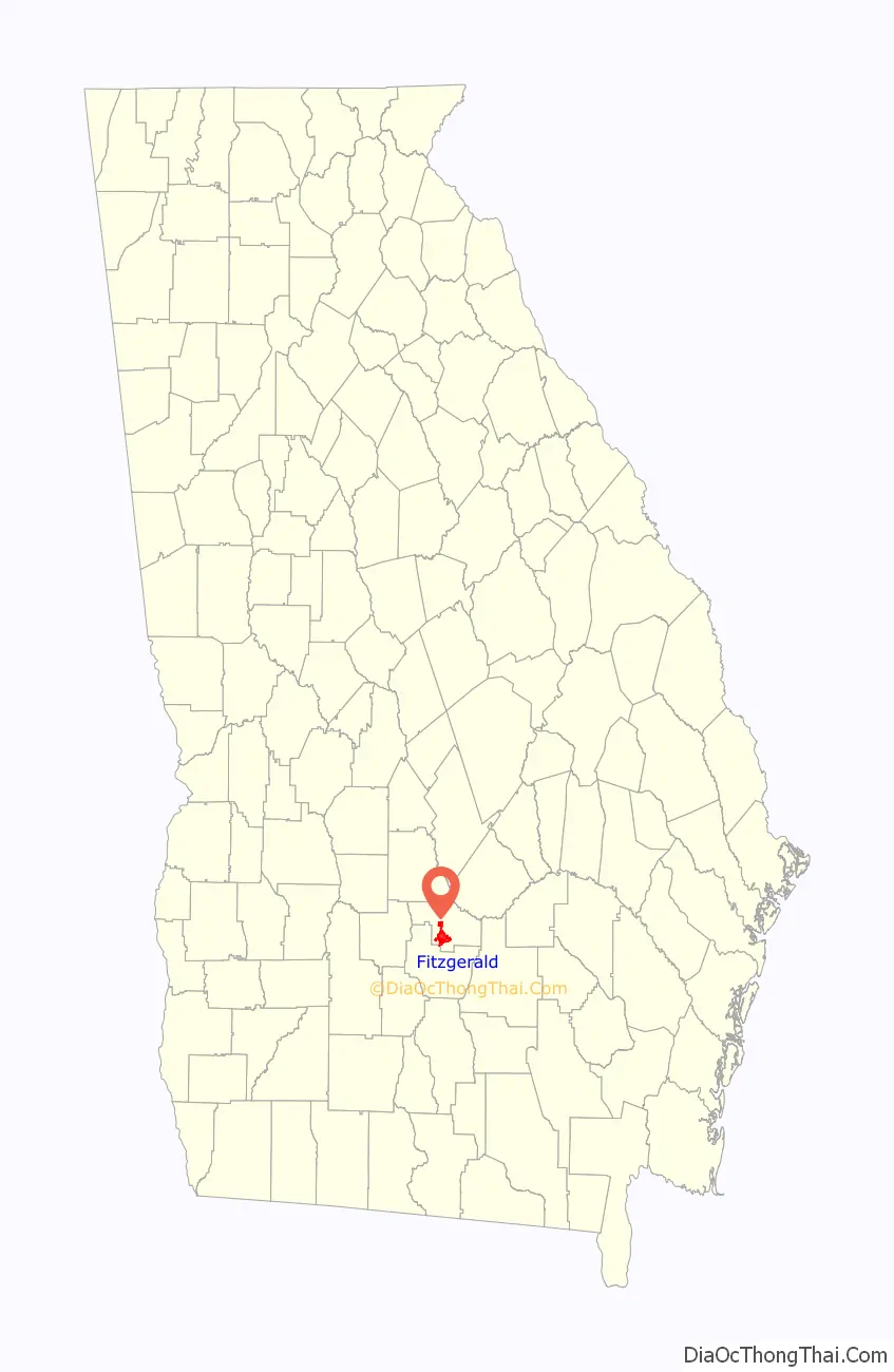
Fitzgerald is a city in and the county seat of Ben Hill County in the south central portion of the U.S. state of Georgia. As of the 2010 census, it had a population of 9,053. It is the principal city of the Fitzgerald Micropolitan Statistical Area, which includes all of Ben Hill and Irwin counties.
| Name: | Fitzgerald city |
|---|---|
| LSAD Code: | 25 |
| LSAD Description: | city (suffix) |
| State: | Georgia |
| County: | Ben Hill County, Irwin County |
| Elevation: | 361 ft (110 m) |
| Total Area: | 9.13 sq mi (23.64 km²) |
| Land Area: | 8.98 sq mi (23.25 km²) |
| Water Area: | 0.15 sq mi (0.39 km²) |
| Total Population: | 9,006 |
| Population Density: | 1,003.23/sq mi (387.34/km²) |
| ZIP code: | 31750 |
| Area code: | 229 |
| FIPS code: | 1329528 |
| GNISfeature ID: | 0355809 |
| Website: | www.fitzgeraldga.org |
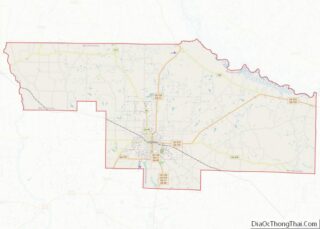
Online Interactive Map
Click on ![]() to view map in "full screen" mode.
to view map in "full screen" mode.
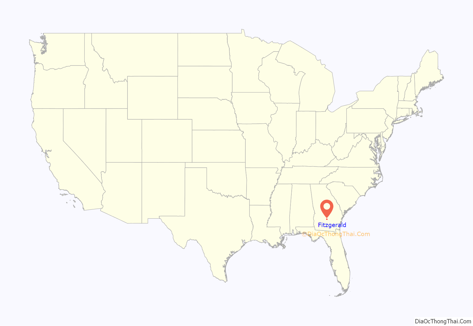
Fitzgerald location map. Where is Fitzgerald city?
History
Fitzgerald was developed in 1895 by Philander H. Fitzgerald, an Indianapolis newspaper editor. A former drummer boy in the Union Army during the Civil War, he founded it as a community for war veterans – both from the Union and from the Confederacy. The majority of the first citizens (some 2700) were Union veterans. It was incorporated on December 2, 1896. The town is located less than 15 miles (24 km) from the site where Confederate president Jefferson Davis was captured on May 10, 1865.
Fitzgerald was an early planned city. It was laid out as a square, with intersecting streets dividing it into four wards. Each of the wards was divided into four blocks and each block had sixteen squares. The first two streets running north–south on the west side of the city were named after Confederate generals Lee and Johnston, whereas the first two on the east side were named after Union generals Grant and Sherman.
After about a year, the residents planned a Thanksgiving harvest parade. Separate Union and Confederate parades were planned. But when the band struck up to play, the Confederates joined the Union veterans to march as one under the US flag. This was at a time of increasing reconciliation nationwide between white soldiers of the North and South; historian David Blight notes that outstanding issues of race were pushed aside. In this period southern states had already begun to pass new constitutions that raised barriers to voter registration, following Mississippi’s in 1890, and essentially disenfranchised most freedmen and many poor whites. By 1900, Fitzgerald was a sundown town, prohibiting African Americans from living there.
In recent years, the unofficial, and sometimes controversial, mascot of the city has become the red junglefowl, a wild chicken native to the Indian subcontinent. In the late 1960s, a small number were released into the woods surrounding the city and have thrived to this day. In 2019, work began on a 62-foot (19 m) tall topiary statue of a chicken.
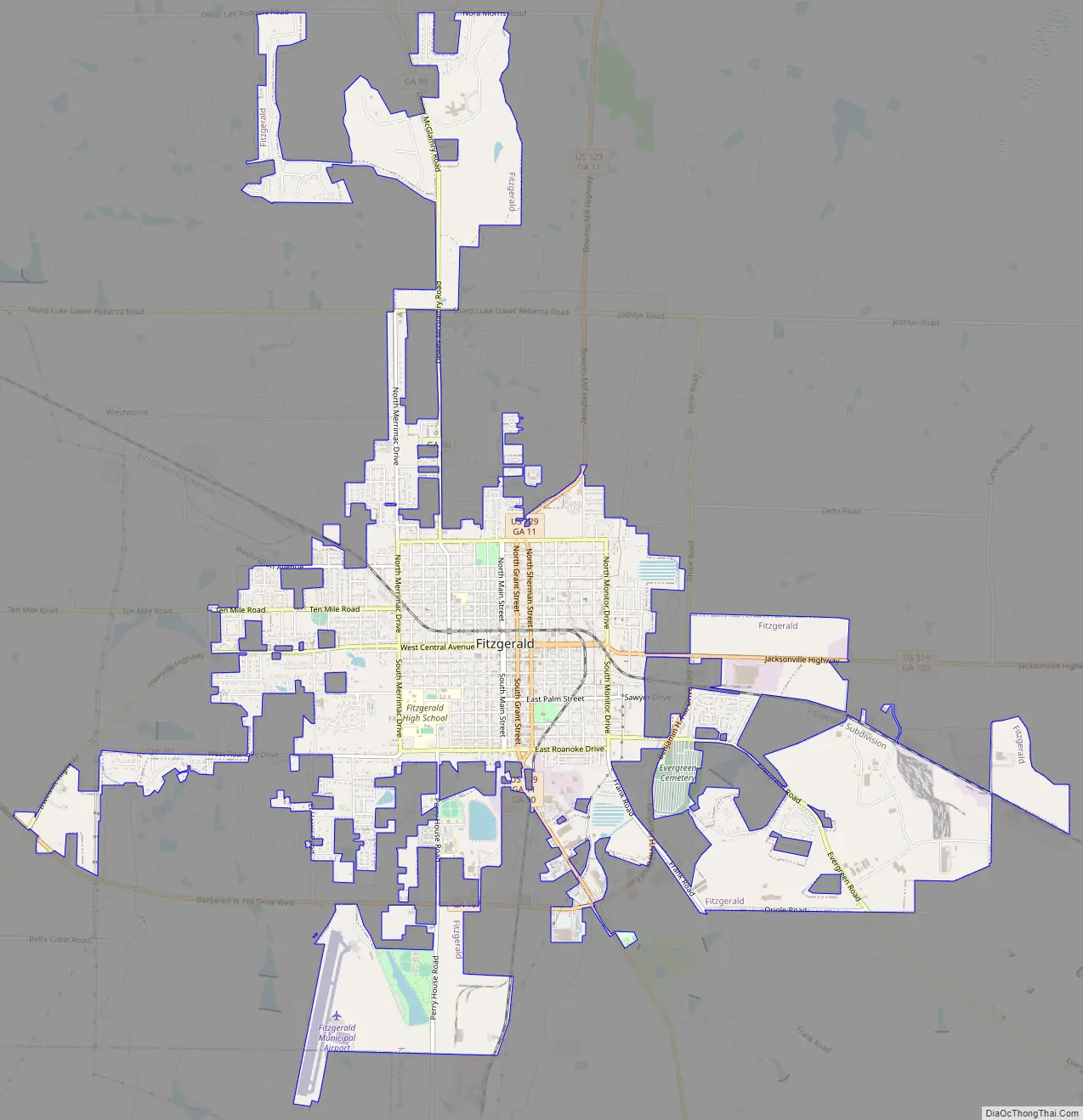
Fitzgerald Road Map
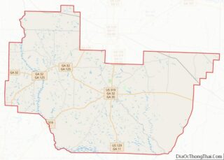
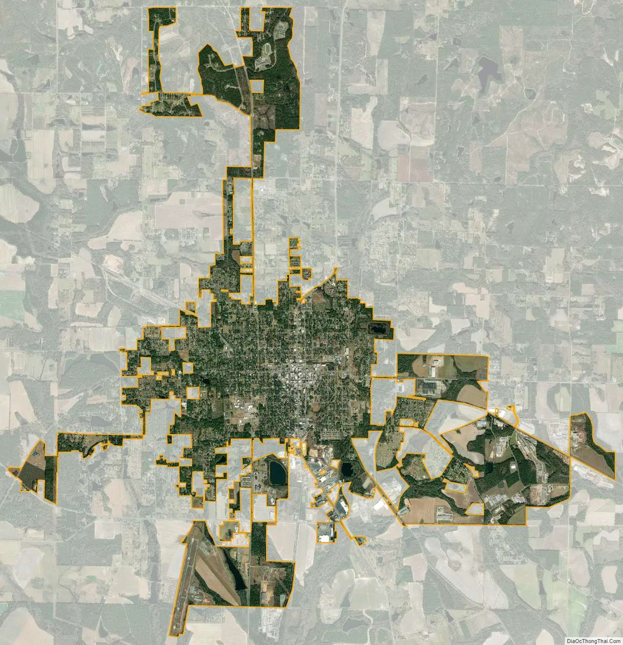
Fitzgerald city Satellite Map
Geography
Fitzgerald is located in south central Georgia at 31°42′56″N 83°15′23″W / 31.71556°N 83.25639°W / 31.71556; -83.25639 (31.715432, -83.256464). U.S. Route 129 passes through the center of the city, leading north to Abbeville, Hawkinsville, and eventually Macon, and south to Ocilla, Nashville, and Lakeland. U.S. Route 319 also passes through Fitzgerald, leading northeast to McRae and Dublin and southwest to Tifton.
According to the United States Census Bureau, the city has a total area of 9.0 square miles (23.3 km), of which 8.8 square miles (22.9 km) is land and 0.15 square miles (0.4 km), or 1.64%, is water.
Climate
See also
Map of Georgia State and its subdivision:- Appling
- Atkinson
- Bacon
- Baker
- Baldwin
- Banks
- Barrow
- Bartow
- Ben Hill
- Berrien
- Bibb
- Bleckley
- Brantley
- Brooks
- Bryan
- Bulloch
- Burke
- Butts
- Calhoun
- Camden
- Candler
- Carroll
- Catoosa
- Charlton
- Chatham
- Chattahoochee
- Chattooga
- Cherokee
- Clarke
- Clay
- Clayton
- Clinch
- Cobb
- Coffee
- Colquitt
- Columbia
- Cook
- Coweta
- Crawford
- Crisp
- Dade
- Dawson
- Decatur
- DeKalb
- Dodge
- Dooly
- Dougherty
- Douglas
- Early
- Echols
- Effingham
- Elbert
- Emanuel
- Evans
- Fannin
- Fayette
- Floyd
- Forsyth
- Franklin
- Fulton
- Gilmer
- Glascock
- Glynn
- Gordon
- Grady
- Greene
- Gwinnett
- Habersham
- Hall
- Hancock
- Haralson
- Harris
- Hart
- Heard
- Henry
- Houston
- Irwin
- Jackson
- Jasper
- Jeff Davis
- Jefferson
- Jenkins
- Johnson
- Jones
- Lamar
- Lanier
- Laurens
- Lee
- Liberty
- Lincoln
- Long
- Lowndes
- Lumpkin
- Macon
- Madison
- Marion
- McDuffie
- McIntosh
- Meriwether
- Miller
- Mitchell
- Monroe
- Montgomery
- Morgan
- Murray
- Muscogee
- Newton
- Oconee
- Oglethorpe
- Paulding
- Peach
- Pickens
- Pierce
- Pike
- Polk
- Pulaski
- Putnam
- Quitman
- Rabun
- Randolph
- Richmond
- Rockdale
- Schley
- Screven
- Seminole
- Spalding
- Stephens
- Stewart
- Sumter
- Talbot
- Taliaferro
- Tattnall
- Taylor
- Telfair
- Terrell
- Thomas
- Tift
- Toombs
- Towns
- Treutlen
- Troup
- Turner
- Twiggs
- Union
- Upson
- Walker
- Walton
- Ware
- Warren
- Washington
- Wayne
- Webster
- Wheeler
- White
- Whitfield
- Wilcox
- Wilkes
- Wilkinson
- Worth
- Alabama
- Alaska
- Arizona
- Arkansas
- California
- Colorado
- Connecticut
- Delaware
- District of Columbia
- Florida
- Georgia
- Hawaii
- Idaho
- Illinois
- Indiana
- Iowa
- Kansas
- Kentucky
- Louisiana
- Maine
- Maryland
- Massachusetts
- Michigan
- Minnesota
- Mississippi
- Missouri
- Montana
- Nebraska
- Nevada
- New Hampshire
- New Jersey
- New Mexico
- New York
- North Carolina
- North Dakota
- Ohio
- Oklahoma
- Oregon
- Pennsylvania
- Rhode Island
- South Carolina
- South Dakota
- Tennessee
- Texas
- Utah
- Vermont
- Virginia
- Washington
- West Virginia
- Wisconsin
- Wyoming