Valdosta is a city in and the county seat of Lowndes County, Georgia, United States. As of 2019, Valdosta had an estimated population of 56,457.
Valdosta is the principal city of the Valdosta Metropolitan Statistical Area, which in 2021 had a population of 149,590. It includes Brooks County to the west.
Valdosta is the home of Valdosta State University, a regional university in the University System of Georgia with over 12,000 students. The football team at Valdosta High School has more wins than any other American high school, and is second in overall wins in the country after University of Michigan.
Valdosta is called the Azalea City, as the plant grows in profusion there. The city hosts an annual Azalea Festival in March.
| Name: | Valdosta city |
|---|---|
| LSAD Code: | 25 |
| LSAD Description: | city (suffix) |
| State: | Georgia |
| County: | Lowndes County |
| Incorporated: | December 7, 1860 |
| Elevation: | 220 ft (67 m) |
| Land Area: | 35.99 sq mi (93.20 km²) |
| Water Area: | 0.44 sq mi (1.15 km²) |
| Population Density: | 1,538.88/sq mi (594.16/km²) |
| Area code: | 229 |
| FIPS code: | 1378800 |
| GNISfeature ID: | 0324649 |
| Website: | www.valdostacity.com |
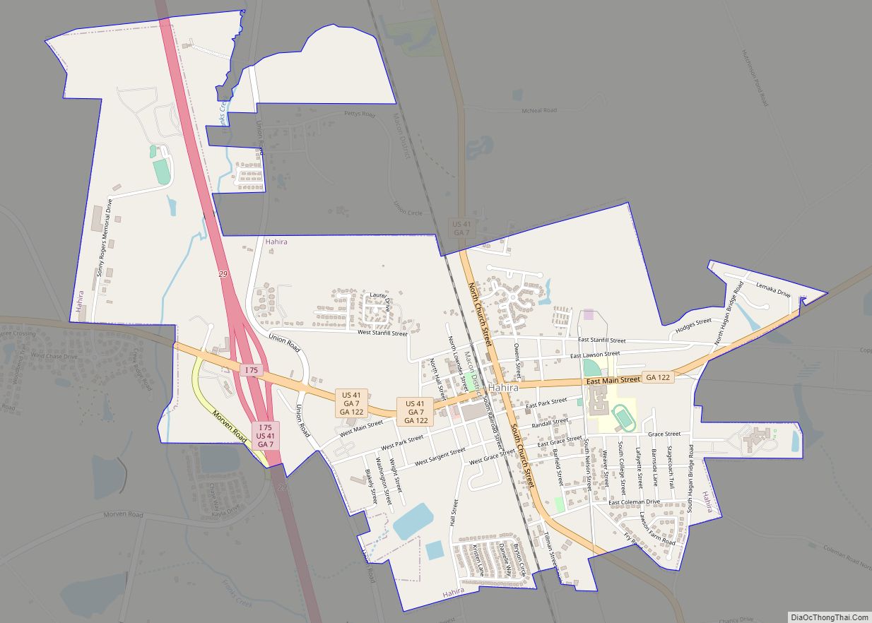
Online Interactive Map
Click on ![]() to view map in "full screen" mode.
to view map in "full screen" mode.
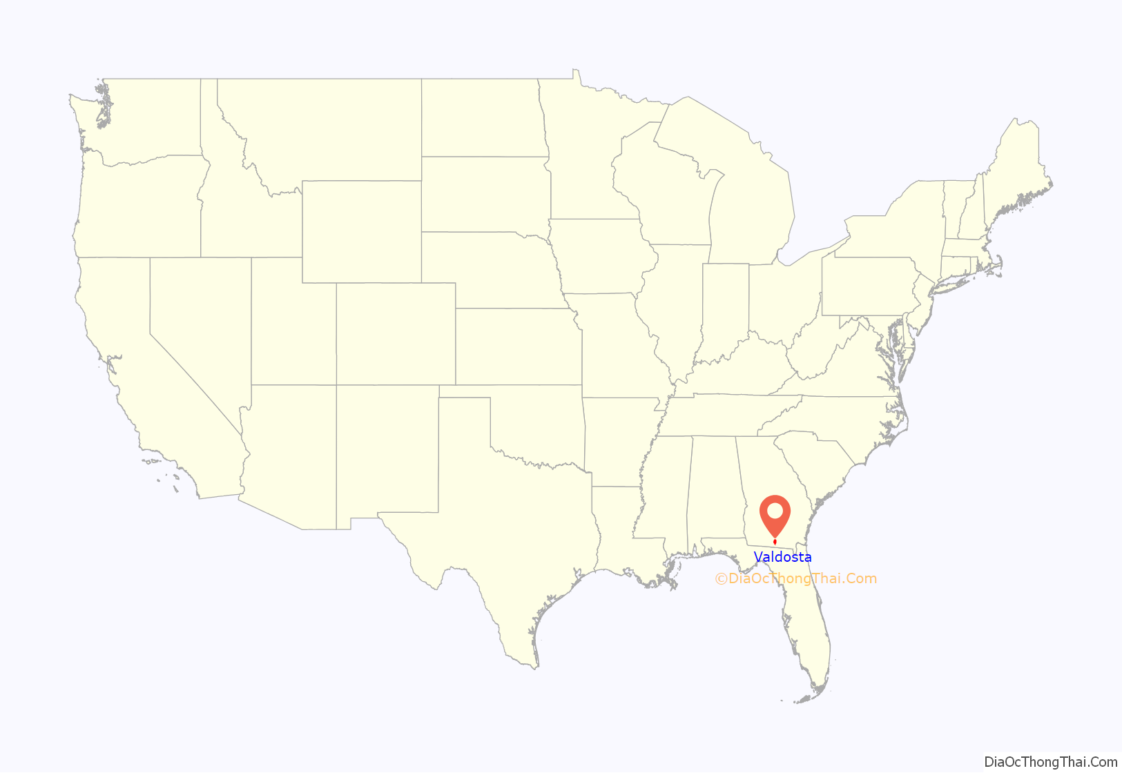
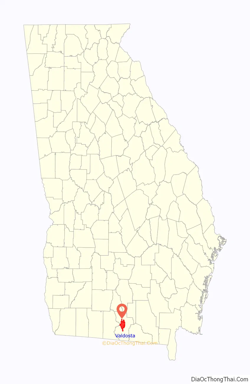
Valdosta location map. Where is Valdosta city?
History
Establishment
Valdosta was incorporated on December 7, 1860, when it was designated by the state legislature as the new county seat, formerly at nearby Troupville. The railroad was built to Valdosta that year, rather than Troupville, stimulating development in the new county seat. Many citizens of Troupville had already relocated to Valdosta when the Atlantic and Gulf Railroad was built 4 miles (6 km) away. The engine known as Satilla No. 3 pulled the first train into Valdosta on the Atlantic and Gulf Railroad on either July 4, 1860 or on July 20, 1860.
Valdosta is located on the Gulf Coastal Plain of Georgia and has a virtually flat landscape. It was once the center of long-staple cotton growing in the United States, a lucrative crop both before and after the Civil War. The county had a majority-white population well before the war with a substantial black population, as the cotton plantations were dependent on masses of enslaved field laborers.
The sixty miles (97 km) of railway between Valdosta and Waycross were once the longest straight stretch of railroad in the world. Today, highways stretch through the county for miles with hardly a curve, rise, or fall.
After being bypassed by the railroad and losing the county seat, Troupville was virtually abandoned. It had been named after Governor George Troup, for whom Troup County, Georgia, was also named. Valdosta was named after Troup’s plantation, Valdosta (occasionally the “Val d’Osta” spelling was used for the plantation). Troup had named it after the Aosta Valley (Piedmontese: Val d’Osta) in Italy. The name Aosta (Latin: Augusta), refers to Emperor Augustus. A long-standing rumor held that the city’s name meant “vale of beauty.”
1861 to 1899
The American Civil War erupted just months after the establishment of Valdosta. During the war, Valdosta was far away from battles and became a refuge for those fleeing areas of Georgia where the war was being actively fought.
After the Civil War, during the Reconstruction era, more than 100 freedmen, families of farmers, craftsmen, and laborers, emigrated from Lowndes County to Arthington, Liberia, in 1871 and 1872, looking for a better life. Since before the war, the American Colonization Society had supported the relocation of free blacks to Liberia, an American colony in West Africa established for this purpose. The first group from Lowndes County left in 1871, and were led by Jefferson Bracewell; the second group was led in 1872 by Aaron Miller. Many freedmen ended up working as sharecroppers and tenant farmers on area plantations in Lowndes County, as cotton agriculture continued well into the 20th century.
One notable event during Reconstruction was at a political meeting in front of the courthouse. A carpetbagger named J. W. Clift was running for Congress and was looking for support from former slaves. During Clift’s speech he verbally attacked whites of Valdosta. In response five men planted explosives at the courthouse, planning on setting them off at Clift’s next political rally. When other whites arrived at the courthouse unaware of the explosives the five men decided to stop the explosives but some still managed to go off. The explosion was small and no injuries occurred. The five men were arrested and were going to go on trial, but federal soldiers took them to Savannah for trial, which was seen by residents as an overreach of authority and an endangerment for self-government.
As mechanization was introduced, the number of agricultural jobs decreased and Valdosta became more industrialized by the 20th century. The world’s second Coca-Cola bottling plant began bottling Coca-Cola in Valdosta in 1897. In 1899, the cotton mill town of Remerton was established 2 miles (3 km) from the center of Valdosta. It has since become an enclave to the growth of Valdosta around Remerton.
First half of the 20th century
A new courthouse was planned in 1900 to replace the smaller courthouse. Construction began in 1904 for around $75,000. The old courthouse was torn down in March 1904. The new courthouse was completed in 1904, and on April 14, 1905, the first session of court took place in the new courthouse.
In November 1902, the Harris Nickel-Plate Circus’ prize elephant, Gypsy, went on a rampage and killed her trainer James O’Rourke. After terrorizing the town for a couple of hours, she ran off to Cherry Creek, north of Valdosta. Gypsy was chased by Police Chief Calvin Dampier and a posse. Gypsy was shot and killed and buried on site. James O’Rourke was buried in Sunset Hill Cemetery in Valdosta.
On July 28, 1907, Valdosta voted to become a dry city; a record $10,000 worth of whiskey was sold on the last day. The city had been wet since its founding.
In 1910, cotton was still important to the economy, and Fortune magazine ranked Valdosta as the richest city in America by per capita income. Soon after that, the boll weevil invaded the South, moving east through the states and killing much of the cotton crop in this area in 1917. Agriculture in this area turned to tobacco and pine timber. In January 1913, the South Georgia State Normal College opened in Valdosta on the edge of town. Over the course of the following century, it evolved into Valdosta State University. The school gradually became a regional center of higher education that has drawn many to the city.
On May 16, 1918, a white planter named Hampton Smith was shot and killed at his house near Morven, Georgia, by a black farm worker named Sidney Johnson who was routinely mistreated by Smith. Johnson also shot Smith’s wife but she later recovered. Johnson hid for several days in Valdosta without discovery. Lynch mobs formed in Valdosta ransacking Lowndes and Brooks counties for a week looking for Johnson and his alleged accomplices. These mobs lynched at least 13 African Americans, among them Mary Turner and her unborn eight-month-old baby who was cut from her body and murdered. Mary Turner’s husband Hazel Turner was also lynched the day before.
Sidney Johnson was turned in by an acquaintance, and on May 22 Police Chief Calvin Dampier led a shootout at the Valdosta house where he was hiding. Following his death, a crowd of more than 700 castrated Johnson’s body, then dragged it behind a vehicle down Patterson Street and all the way to Morven, Georgia, near the site of Smith’s murder. There the body of Johnson was hanged and burned on a tree. That afternoon, Governor Hugh Dorsey ordered the state militia to be dispatched to Valdosta to halt the lynch mobs, but they arrived too late for many victims. Dorsey later denounced the lynchings, but none of the participants were ever prosecuted.
Following the violence, more than 500 African Americans fled from Lowndes and Brooks counties to escape such oppressive conditions and violence. From 1880 to 1930, Brooks County had the highest number of lynchings in the state of Georgia. By 1922 local chapters of the Ku Klux Klan, which had been revived starting in 1915, were holding rallies openly in Valdosta.
Second half of the 20th century
On June 26, 1941, Moody Army Airfield opened 10 miles (16 km) northeast of town as part of the United States’ preparation for the country’s potential involvement in World War II. Moody Air Force Base’s role in World War II and the postwar era has influenced the growth of Valdosta.
The local economy received an important boost in the mid-20th century when Interstate 75 was routed and built through the area. Many vacationers on their way to Florida found Valdosta a convenient “last stop” on their way to Walt Disney World and the Orlando area. The Interstate’s route to the west of the city has contributed to its commercial district shifting from the historic downtown area to near the Interstate.
Valdosta State College was integrated in September 1963. In 1969, Valdosta High School (the formerly all-white school) and Pinevale High School (the formerly all-black school) were merged into one system. Integration had begun at Valdosta High School about 1966.
During the Vietnam War, future president George W. Bush entered the National Guard, receiving flight training at Valdosta’s Moody Air Force Base in November 1968.
In 1994 Kent and Dawn Buescher opened Liberty Farms Animal Park with a playground, entertainment venue and a collection of animals. An amusement park was added, and in 1996 Liberty Farms Animal Park was renamed Wild Adventures. Wild Adventures expanded with Splash Island Water Park in 2002. The Buescher family purchased a botanical garden and theme park called Cypress Gardens in 2004. Due to damage from three hurricanes and a financial struggle in repairing Cypress Gardens the Buescher family were forced to sell Wild Adventures to Herschend Family Entertainment in 2007.
According to the Bureau of Labor Statistics’ Monthly Labor Review, the first automated teller machine (ATM) was installed at a C&S Bank in Valdosta in 1971. That ATM was preceded by one installed in Rockville Centre, New York, in 1969.
21st century
Valdosta was named as one of 2003’s “Top 100 U.S. Small Towns” by Site Selection magazine. In 2010 Valdosta was named one of the “Best Small Places For Business and Careers” by Forbes.
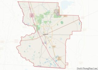
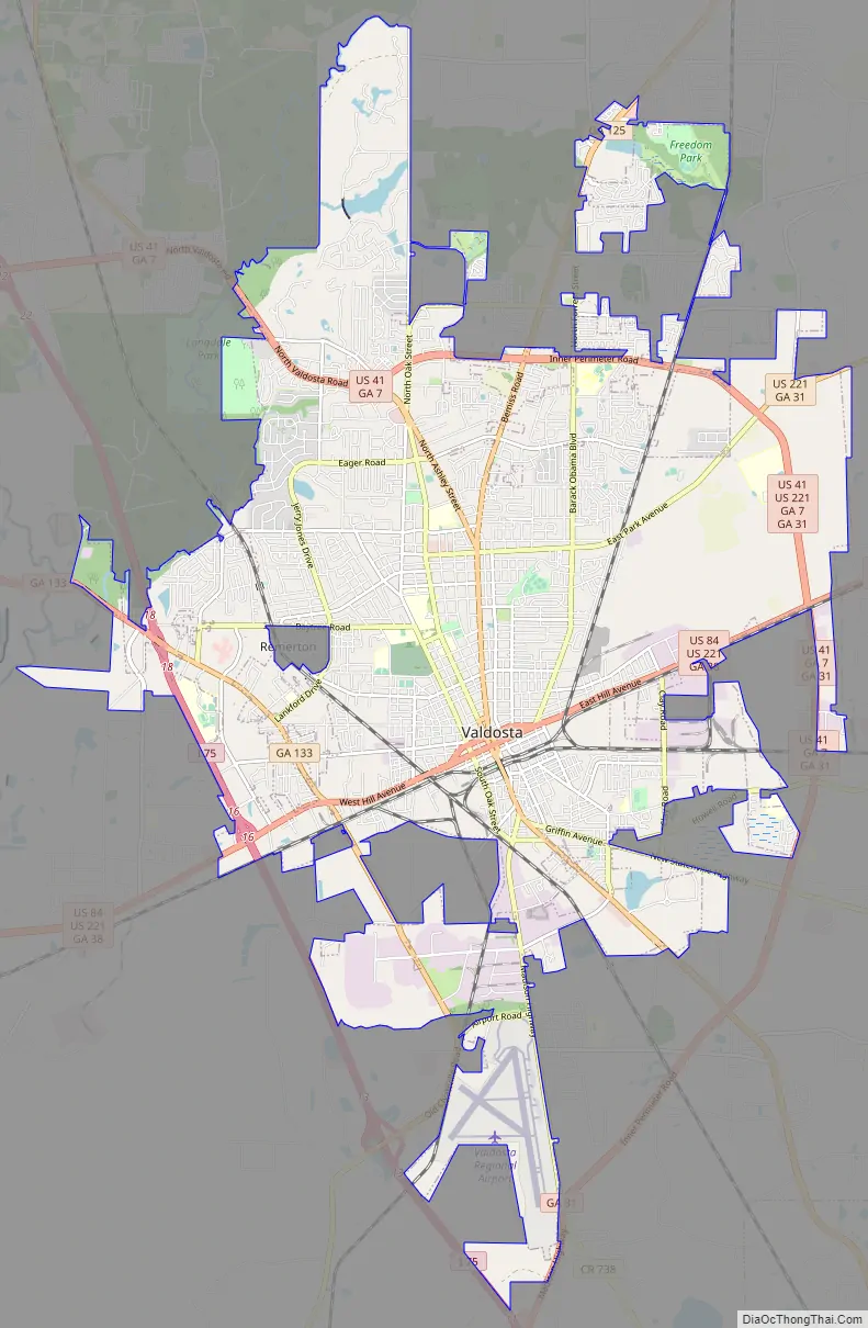
Valdosta Road Map
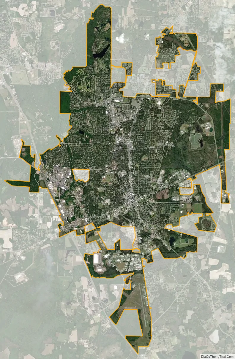
Valdosta city Satellite Map
Geography
Valdosta is located in central Lowndes County at 30°50′48″N 83°16′59″W / 30.84667°N 83.28306°W / 30.84667; -83.28306 (30.846661, -83.283101), 15 miles (24 km) north of the Florida state line. It is about 230 miles (370 km) south of Atlanta, 138 miles (222 km) east of Dothan, Alabama, and 120 miles (190 km) northwest of Jacksonville, Florida.
According to the United States Census Bureau, the city has a total area of 36.4 square miles (94.3 km), of which 35.9 square miles (93.1 km) are land and 0.46 square miles (1.2 km), or 1.26%, are water. The Withlacoochee River, a tributary of the Suwannee River, runs along part of the western edge of the city, while the eastern side of the city drains to Mud Creek, flowing southeast to the Alapahoochee River, also part of the Suwannee River watershed.
Climate
Valdosta has a humid subtropical climate (Köppen climate classification: Cfa), with mild, dry/wet winters and hot, humid summers. Temperatures frequently go over 90 °F (32.2 °C), but in extreme heatwaves, temperatures occasionally go over 100 °F (37.8 °C). Snowfall is rare but not unknown. Snow fell in Valdosta most recently on January 3, 2018, but the last significant snowfall happened in 1989. However, light frosts regularly occur between December and February. Valdosta can experience Indian summers in the winter, where temperatures can get quite warm. Very rarely do winter lows go below 25 °F (−3.9 °C).
See also
Map of Georgia State and its subdivision:- Appling
- Atkinson
- Bacon
- Baker
- Baldwin
- Banks
- Barrow
- Bartow
- Ben Hill
- Berrien
- Bibb
- Bleckley
- Brantley
- Brooks
- Bryan
- Bulloch
- Burke
- Butts
- Calhoun
- Camden
- Candler
- Carroll
- Catoosa
- Charlton
- Chatham
- Chattahoochee
- Chattooga
- Cherokee
- Clarke
- Clay
- Clayton
- Clinch
- Cobb
- Coffee
- Colquitt
- Columbia
- Cook
- Coweta
- Crawford
- Crisp
- Dade
- Dawson
- Decatur
- DeKalb
- Dodge
- Dooly
- Dougherty
- Douglas
- Early
- Echols
- Effingham
- Elbert
- Emanuel
- Evans
- Fannin
- Fayette
- Floyd
- Forsyth
- Franklin
- Fulton
- Gilmer
- Glascock
- Glynn
- Gordon
- Grady
- Greene
- Gwinnett
- Habersham
- Hall
- Hancock
- Haralson
- Harris
- Hart
- Heard
- Henry
- Houston
- Irwin
- Jackson
- Jasper
- Jeff Davis
- Jefferson
- Jenkins
- Johnson
- Jones
- Lamar
- Lanier
- Laurens
- Lee
- Liberty
- Lincoln
- Long
- Lowndes
- Lumpkin
- Macon
- Madison
- Marion
- McDuffie
- McIntosh
- Meriwether
- Miller
- Mitchell
- Monroe
- Montgomery
- Morgan
- Murray
- Muscogee
- Newton
- Oconee
- Oglethorpe
- Paulding
- Peach
- Pickens
- Pierce
- Pike
- Polk
- Pulaski
- Putnam
- Quitman
- Rabun
- Randolph
- Richmond
- Rockdale
- Schley
- Screven
- Seminole
- Spalding
- Stephens
- Stewart
- Sumter
- Talbot
- Taliaferro
- Tattnall
- Taylor
- Telfair
- Terrell
- Thomas
- Tift
- Toombs
- Towns
- Treutlen
- Troup
- Turner
- Twiggs
- Union
- Upson
- Walker
- Walton
- Ware
- Warren
- Washington
- Wayne
- Webster
- Wheeler
- White
- Whitfield
- Wilcox
- Wilkes
- Wilkinson
- Worth
- Alabama
- Alaska
- Arizona
- Arkansas
- California
- Colorado
- Connecticut
- Delaware
- District of Columbia
- Florida
- Georgia
- Hawaii
- Idaho
- Illinois
- Indiana
- Iowa
- Kansas
- Kentucky
- Louisiana
- Maine
- Maryland
- Massachusetts
- Michigan
- Minnesota
- Mississippi
- Missouri
- Montana
- Nebraska
- Nevada
- New Hampshire
- New Jersey
- New Mexico
- New York
- North Carolina
- North Dakota
- Ohio
- Oklahoma
- Oregon
- Pennsylvania
- Rhode Island
- South Carolina
- South Dakota
- Tennessee
- Texas
- Utah
- Vermont
- Virginia
- Washington
- West Virginia
- Wisconsin
- Wyoming