Evansville is a city in and the county seat of Vanderburgh County, Indiana, United States. The population was 118,414 at the 2020 census, making it the state’s third-most populous city after Indianapolis and Fort Wayne, the largest city in Southern Indiana, and the 249th-most populous city in the United States. It is the central city of the Evansville metropolitan area, a hub of commercial, medical, and cultural activity of southwestern Indiana and the Illinois–Indiana–Kentucky tri-state area, that is home to over 911,000 people. The 38th parallel crosses the north side of the city and is marked on Interstate 69.
Situated on an oxbow in the Ohio River, the city is often referred to as the “Crescent Valley” or “River City”. Early French explorers named it La Belle Rivière (“The Beautiful River”). The area has been inhabited by various indigenous cultures for millennia, dating back at least 10,000 years. Angel Mounds was a permanent settlement of the Mississippian culture from 1000 AD to around 1400 AD. The European-American city was founded in 1812.
Evansville anchors a regional economic hub based primarily on trade, transportation, and utilities; professional and business services; education and health services; government; leisure and hospitality; and manufacturing. Two NYSE-listed companies (Berry Global and OneMain Financial) are headquartered in Evansville, and three companies traded on NASDAQ (Escalade, Old National Bank, and Shoe Carnival) are also headquartered in Evansville.
Evansville is home to Bally’s Evansville, the state’s first casino; Mesker Park Zoo and Botanic Garden, one of the state’s oldest and largest zoos; and sports tourism industry. The city has several notable educational institutions. The University of Evansville is a private school on the city’s east side, while the University of Southern Indiana is a larger public institution just outside the city’s westside limits. The Indiana University School of Medicine also maintains a campus in Evansville. Other local educational institutions include the nationally ranked Signature School, the Evansville Vanderburgh Public Library, and the Evansville Vanderburgh School Corporation.
| Name: | Evansville city |
|---|---|
| LSAD Code: | 25 |
| LSAD Description: | city (suffix) |
| State: | Indiana |
| County: | Vanderburgh County |
| Founded: | 1812 |
| Incorporated: | 1817 |
| Elevation: | 384 ft (117 m) |
| Land Area: | 47.35 sq mi (122.65 km²) |
| Water Area: | 0.49 sq mi (1.28 km²) |
| Population Density: | 2,476.99/sq mi (956.37/km²) |
| ZIP code: | 40 total ZIP codes: 47701, 47702, 47703, 47704, 47705, 47706, 47708, 47710, 47711, 47712, 47713, 47714, 47715, 47716, 47719, 47720, 47721, 47722, 47724, 47725, 47726, 47727, 47728, 47730, 47731, 47732, 47733, 47734, 47735, 47736, 47737, 47739, 47740, 47741, 47744, 47747, 47750, 47755, 47761, 47777 |
| Area code: | 812 & 930 |
| FIPS code: | 1822000 |
| GNISfeature ID: | 434258 |
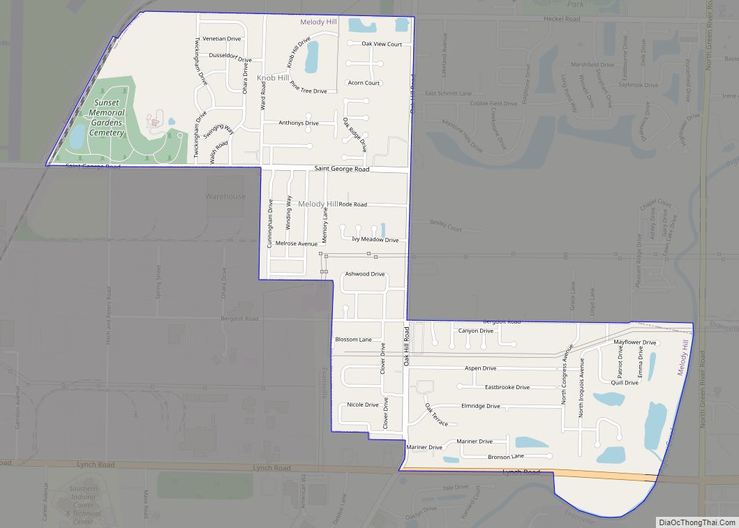
Online Interactive Map
Click on ![]() to view map in "full screen" mode.
to view map in "full screen" mode.
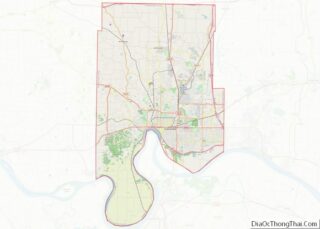
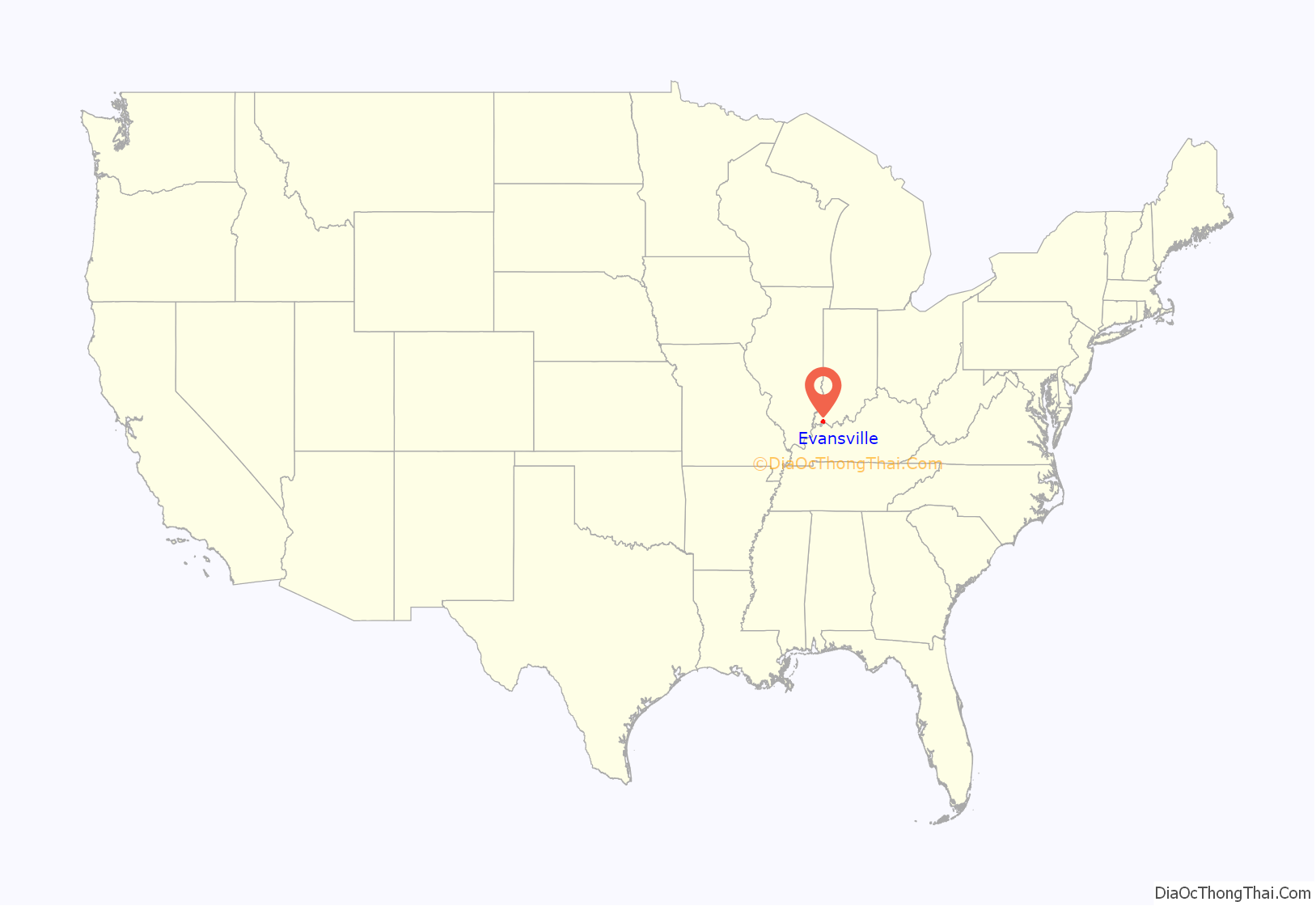
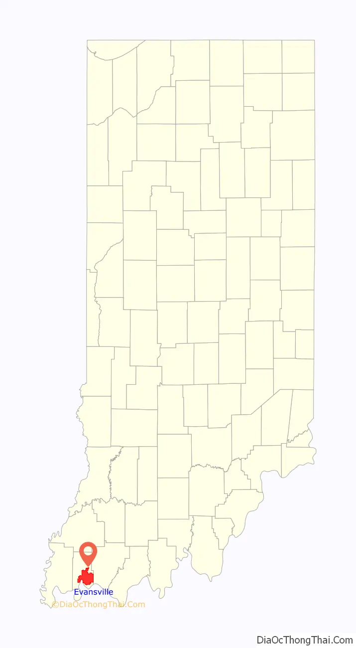
Evansville location map. Where is Evansville city?
History
There has been a continuous human presence in the area that became Evansville from at least 8,000 BC by Paleo-Indians. Archaeologists have identified several archaic and ancient sites in and near Evansville, with the most complex at Angel Mounds. This was built and occupied from about 900 A.D. to about 1600 A.D., just before the arrival of Europeans to North America.
Following the abandonment of Angel Mounds between the years 1400 and 1450, tribes of the historic Miami, Shawnee, Piankeshaw, Wyandot, Delaware and other Native American peoples were known to be in the area. French hunters and trappers were among the first Europeans to come to the area, using Vincennes as a base of operations for fur trading. As a testament to the Ohio River’s grandeur, early French explorers named it La Belle Rivière (“The Beautiful River”). The land encompassing Evansville was formally relinquished by the Delaware in 1805 to General William Henry Harrison, then governor of the Indiana Territory.
The city of Evansville, Indiana was founded in 1812 and incorporated in 1817. It is situated on an oxbow in the Ohio River, and is often referred to as the “Crescent Valley” or “River City”.
On March 27, 1812, Hugh McGary Jr. purchased about 441 acres and named it “McGary’s Landing”. In 1814, to attract more people, McGary renamed his village “Evansville” in honor of Colonel Robert Morgan Evans. Evansville incorporated in 1817 and was designated as the county seat on January 7, 1818. The county was named for Henry Vanderburgh, a deceased chief judge of the Indiana Territorial Supreme Court.
Evansville became a thriving commercial town with a river trade, and the town began to expand outside of its original footprint. Evansville’s west side was for many years cut off from the city’s main part by Pigeon Creek and the factories that developed along it, making the creek an industrial corridor. The land comprising the former town of Lamasco was platted in 1837 and was annexed in 1870.
Evansville’s economy received a boost in the early 1830s when Indiana unveiled plans to build the longest canal in the world, a 400-mile ditch to connect the Great Lakes at Toledo, Ohio with the inland rivers at Evansville. The project was intended to open Indiana to commerce and improve transportation from New Orleans to New York City. The project bankrupted the state and was so poorly engineered that it would not hold water. By the time the Wabash and Erie Canal was finished in 1853, Evansville’s first railroad, Evansville & Crawfordsville Railroad, was opened to Terre Haute. The expansion of railroads in this territory had made the canal obsolete. Only two flat barges ever made the entire trip. The canal basin at Fifth and Court street in downtown Evansville became the site of a new courthouse in 1891.
The era of Evansville’s greatest growth occurred in the second half of the 19th century, following the disruptions of the Civil War. The city was a major stop for steamboats along the Ohio River, and it was the home port for a number of companies engaged in trade via the river. Coal mining, manufacturing, and hardwood lumber was a major source of economic activity. By 1900, Evansville was one of the world’s largest hardwood furniture centers, with 41 factories employing approximately 2,000 workers. Railroads eventually became more important and in 1887 the L&N Railroad constructed a bridge across the Ohio River. Along with a major rail yard southwest of Evansville in Howell, which was annexed in 1916 and completed the city’s counterclockwise march around the horseshoe bend.
Throughout this period, Evansville’s main ethnic groups consisted of Protestant Scotch-Irish from the South, Catholic Irish coming for canal or railroad work, New England businessmen, Germans fleeing Europe after the 1848 revolutions, and freedmen from western Kentucky. By the 1890 census, Evansville ranked as the 56th-largest urban area in America, but it was surpassed in population by other cities in the early 1900s. As the new century began, the city continued to develop to its eastern areas. Manufacturing also took off, particularly in the automobile and refrigeration industries.
The Graham brothers, Ray, Robert, and Joseph, got their start with a successful glass factory in Evansville. After they sold it in 1907, the glass factory became Libbey-Owens-Ford. In 1916, seeing the need for a dependable truck, the Graham brothers entered the truck chassis business. Evansville was home to Graham Brothers Trucks from then until 1929. The dependability of Graham trucks was due in part to their use of Torbensen internal gear drive rear axles.
In 1921, after the death of both Dodge brothers, Graham Brothers started selling 1.5 ton pickups through Dodge dealers. (Dodge did not manufacture trucks at the time). These vehicles had Graham chassis and some Dodge parts. Dodge Brothers bought a controlling interest in Graham Brothers in 1925, picking up the rest in 1926.
The city saw exponential growth in the early twentieth century with the production of lumber and the manufacturing of furniture. By 1920, Evansville had more than two dozen furniture companies. In the decades of the 1920s and 1930s, city leaders attempted to improve Evansville’s transportation position and successfully lobbied to be on the Chicago-to-Miami “Dixie Bee Highway” (U.S. Highway 41). A bridge was built across the Ohio River in 1932 and in that same decade steps were taken to develop an airport.
But the Ohio River flood of 1937 covered 500 city blocks in Evansville, resulting in a major crisis. With steamboats less necessary to the local economy, city and federal officials responded to the flood and its destruction by constructing more and higher levees: construction that penned and hid the Ohio River behind a barrier of earthen berms and concrete walls.
During World War II, Evansville was a major center of industrial production which helped revive the regional economy after the Great Depression. A huge, 45-acre shipyard complex was constructed on the riverfront east of St. Joseph Avenue for the production of oceangoing LSTs (Landing Ship-Tanks). The Evansville Shipyard was the nation’s largest inland producer of LSTs. The Plymouth factory was converted into a plant which turned out “bullets by the billions,” and many other companies switched over to the manufacture of war material. In 1942, the city acquired a factory adjacent to the airport north of the city for the manufacture of the P-47 Thunderbolt fighter aircraft, known as the P-47Ds. Evansville produced a total of 6,242 P-47s, almost half of the P-47s made nationally during the war.
After the war, Evansville’s manufacturing base of automobiles, household appliances, and farm equipment benefited from growing post-war demand. A growing housing demand also caused residential development to leap north and east of the city. However, between 1955 and 1963, a nationwide recession hit Evansville. Among other closures, Servel (which produced refrigerators) went out of business and Chrysler ended its local operations. The economy was saved from near total collapse by 28 businesses that moved into the area, including Whirlpool, Alcoa, and General Electric.
During the final third of the 20th century, Evansville became the hub of the tri-state region’s commercial, medical, and service industries. A 1990s economic spurt was fueled by the growth of the University of Southern Indiana. The arrival of giant Toyota and AK Steel manufacturing plants, as well as Casino Aztar (now Bally’s), Indiana’s first gaming boat, also contributed to the growth of jobs. As the twenty-first century began, Evansville continued in a steady pace of economic diversification and stability.
On December 6, 2022, in recognition of the city’s massive production efforts during World War II, it was announced that Evansville had been designated Indiana’s American World War II Heritage City by the National Park Service.
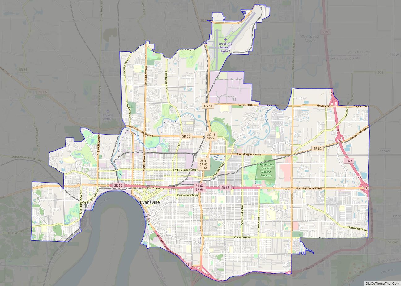
Evansville Road Map
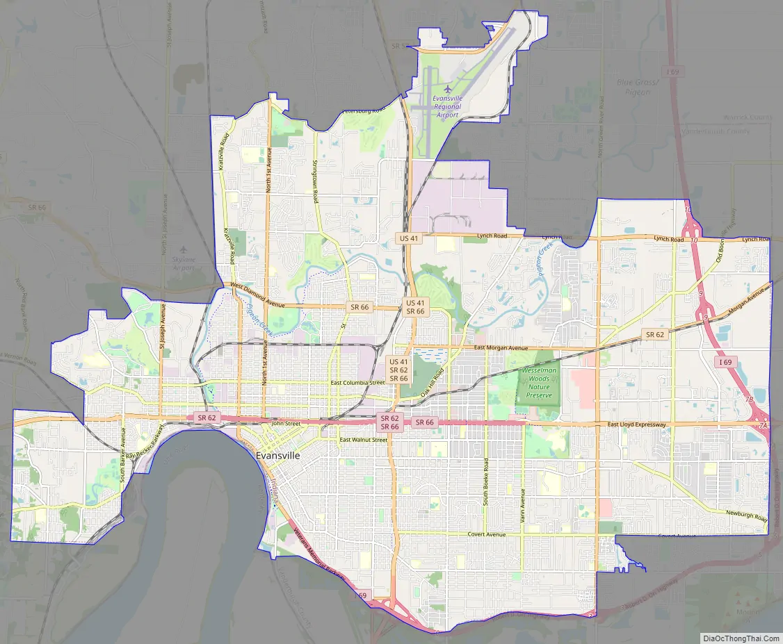
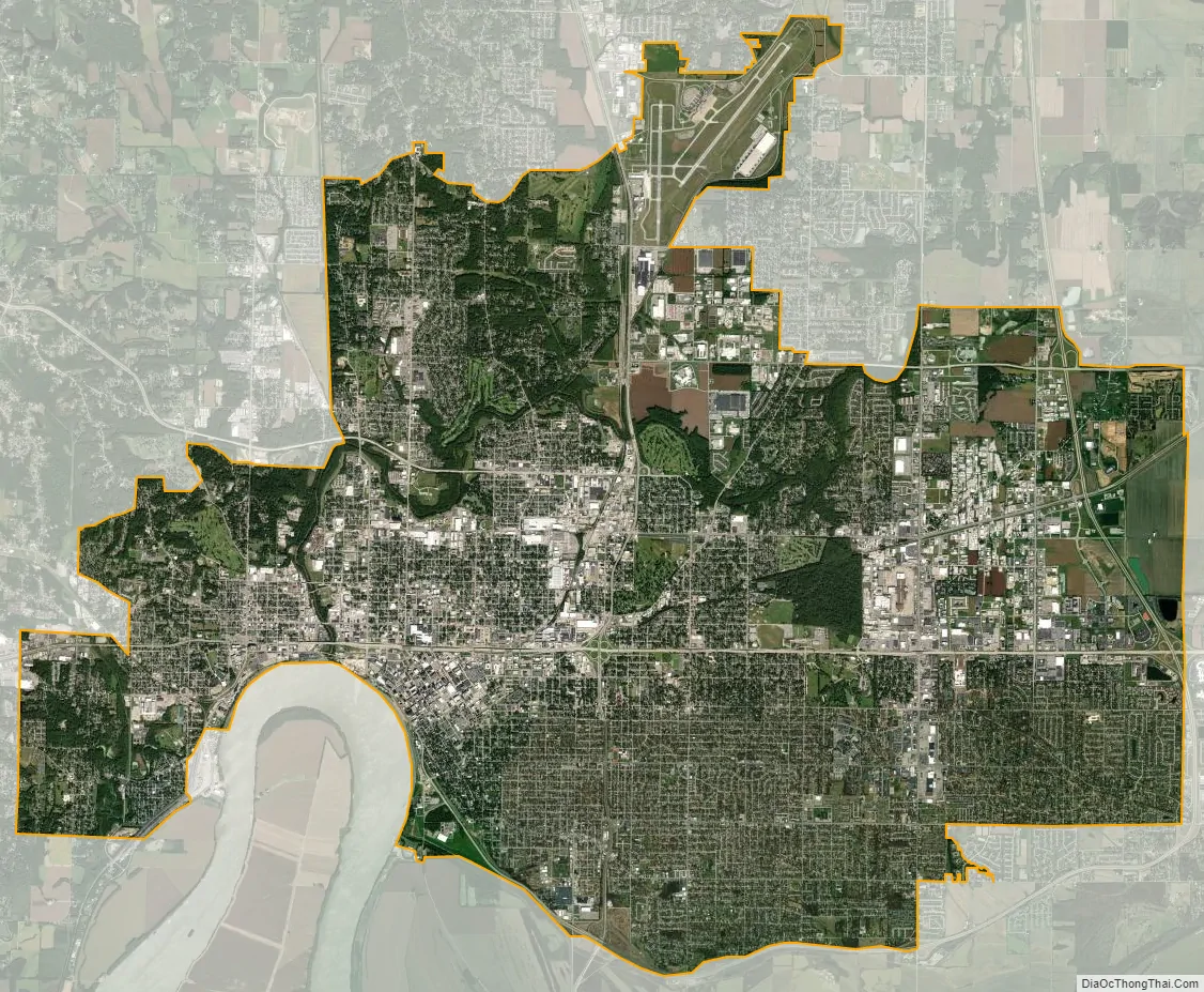
Evansville city Satellite Map
Geography
The Evansville metropolitan area, the 142nd largest in the United States, includes three Indiana counties (Posey, Vanderburgh, and Warrick) and two Kentucky counties (Henderson, and Webster). The metropolitan area does not include Owensboro, Kentucky, which is an adjacent metropolitan area about 30 miles (48 km) southeast of Evansville. This area is sometimes referred to as “Kentuckiana”, although it is usually referred to as the “tri-state” by the local media. Evansville is at 37°58’38” north, 87°33’2″ west (37.977166, −87.550566).
According to the 2010 census, Evansville has an area of 44.622 square miles (115.57 km), of which 44.15 square miles (114.35 km) (or 98.94%) is land and 0.472 square miles (1.22 km) (or 1.06%) is water.
Topography
The city’s southern boundary lies on an oxbow in the Ohio River. Most of the city lies in a shallow valley surrounded by low rolling hills. The city’s west side is built on these rolling hills and is home to Burdette Park, Mesker Amphitheatre, and Mesker Park Zoo. The eastern portion developed in the valley and is protected by a series of levees that closely follow the path of I-69. Notable landmarks on the east side are the 240-acre (1.0 km) Wesselman Woods Nature Preserve and the Angel Mounds State Historic Site, just southeast of Evansville, between Evansville and Newburgh.
Cityscape
For more details on this topic, see List of tallest buildings in Evansville
Evansville’s original downtown plat was made on about 200 acres, with streets running parallel to the river from northwest to southeast. Other streets nearby were later laid out on the cardinal points, due north-south, and east-west. Thus, anyone entering or leaving downtown finds the street makes a confusing oblique-angle turn in one direction or another. In the 1970s, the city suffered from problems such as decreased economic activity and suburban flight, but city-sponsored revitalization has improved downtown conditions.
The business district and riverfront feature land-based casino gambling, restaurants, bars, and shops that attract tens of thousands of visitors each year. Although much of the outer city’s architecture is typical suburban design, the city’s downtown district retains early twentieth-century architecture. A few blocks east of the main business district is the Riverside district, featuring tree-lined brick streets full of turn of the twentieth-century homes. The Reitz Home Museum is one of the finest examples of French second empire architecture in the United States. Other homes nearby feature similar character and design and include Italianate, Colonial Revival, and Renaissance Revival styles.
Neighborhoods
Evansville has thirteen neighborhoods that have qualified as historic districts and are listed on the National Register of Historic Places.
Bayard Park
Culver
Downtown
Haynie’s Corner
Lincolnshire
Riverside
Washington Avenue
West Franklin Street
Climate
Evansville lies within the northern limits of the humid subtropical climate (Köppen Cfa), and straddles the border between USDA plant hardiness zones 6b and 7a. Summers are hot and humid, winters are cold to cool. Average temperatures range from 32.5 °F (0.3 °C) in January to 78.0 °F (25.6 °C) in July. Annual precipitation averages 45.3 inches (1,150 mm), including an average seasonal snowfall of 11.8 inches (30 cm). Evansville winters can range from just 0.5 in (1.3 cm) of snowfall in 2011–12, up to 37.9 in (96 cm) in 1969–70. On average, there are 41 days annually with a maximum temperature of 90 °F (32 °C) or above and 17 days with a maximum at or below freezing; the mean first and last freeze dates are October 26 and April 7, resulting in a frost-free period of 201 days. Extreme temperatures range from −23 °F (−31 °C) on February 2, 1951 up to 111 °F (44 °C) on July 28, 1930; the record cold maximum of −3 °F (−19 °C) was set on January 20, 1985 and December 22, 1989, while, conversely, the record warm minimum of 82 °F (28 °C) was last reached July 8, 1980.
Pollution
In August 2018, the mayor of Evansville sent a letter to the Ohio River Valley Water Sanitation Commission (ORVWSO) opposing a proposal to eliminate pollution control standards for the Ohio River. Evansville is located downstream from the river’s origin. Sources of pollution that affect water quality include agricultural runoff, raw sewage discharges from combined sewer overflows, and toxic chemicals released by companies with water pollution permits. The state of Indiana issues a fish consumption advisory for fish from the Ohio River based on PCB contamination. The recommended consumption limit for most fish, including carp, striped bass and flathead catfish is no more than 8 oz. per month, but for channel catfish, the recommendation is only 8oz every two months.
Six very large coal-fired power plant complexes operate within 30 miles of Evansville: Indiana-Michigan Power’s Rockport Generating Station, near Rockport, Indiana, AES Indiana’s Petersburg Generating Station near Petersburg, and Duke Energy’s Gibson Generating Station near Mount Carmel. Evansville-Based Vectren operates the other two; the A. B. Brown Generating Station, located just west of Evansville, and Warrick County Generating Station/F. B. Culley Generating Station complex, east of Newburgh, largely owned by Alcoa. In addition, another coal fired power plant complex, The R.D. Green Station, operated by Touchstone Energy’s Big Rivers Electric, exists 20 miles south of Evansville, near Sebree, Kentucky. The levels of fine particles in the air in Vanderburgh County were almost as high as in Manhattan, New York City.
A large portion of the downtown and north side areas were declared contaminated by lead and arsenic because of factory dumping dating back to the Civil War. Contractors have been working for more than 20 years to dig up the lawns of residents to make them safe for children to play. About 18 inches of contaminated dirt is dug up from each yard then dumped in a nearby landfill. The work has many more years to go.
See also
Map of Indiana State and its subdivision:- Adams
- Allen
- Bartholomew
- Benton
- Blackford
- Boone
- Brown
- Carroll
- Cass
- Clark
- Clay
- Clinton
- Crawford
- Daviess
- De Kalb
- Dearborn
- Decatur
- Delaware
- Dubois
- Elkhart
- Fayette
- Floyd
- Fountain
- Franklin
- Fulton
- Gibson
- Grant
- Greene
- Hamilton
- Hancock
- Harrison
- Hendricks
- Henry
- Howard
- Huntington
- Jackson
- Jasper
- Jay
- Jefferson
- Jennings
- Johnson
- Knox
- Kosciusko
- LaGrange
- Lake
- Lake Michigan
- LaPorte
- Lawrence
- Madison
- Marion
- Marshall
- Martin
- Miami
- Monroe
- Montgomery
- Morgan
- Newton
- Noble
- Ohio
- Orange
- Owen
- Parke
- Perry
- Pike
- Porter
- Posey
- Pulaski
- Putnam
- Randolph
- Ripley
- Rush
- Saint Joseph
- Scott
- Shelby
- Spencer
- Starke
- Steuben
- Sullivan
- Switzerland
- Tippecanoe
- Tipton
- Union
- Vanderburgh
- Vermillion
- Vigo
- Wabash
- Warren
- Warrick
- Washington
- Wayne
- Wells
- White
- Whitley
- Alabama
- Alaska
- Arizona
- Arkansas
- California
- Colorado
- Connecticut
- Delaware
- District of Columbia
- Florida
- Georgia
- Hawaii
- Idaho
- Illinois
- Indiana
- Iowa
- Kansas
- Kentucky
- Louisiana
- Maine
- Maryland
- Massachusetts
- Michigan
- Minnesota
- Mississippi
- Missouri
- Montana
- Nebraska
- Nevada
- New Hampshire
- New Jersey
- New Mexico
- New York
- North Carolina
- North Dakota
- Ohio
- Oklahoma
- Oregon
- Pennsylvania
- Rhode Island
- South Carolina
- South Dakota
- Tennessee
- Texas
- Utah
- Vermont
- Virginia
- Washington
- West Virginia
- Wisconsin
- Wyoming