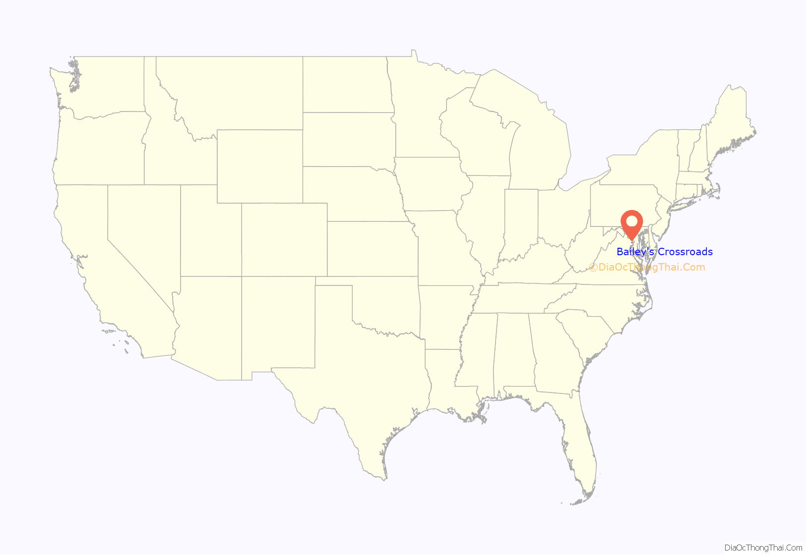
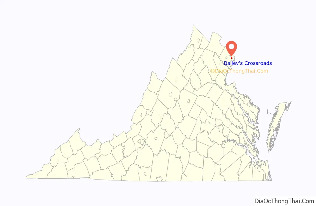
Bailey’s Crossroads is a census-designated place (CDP) in Fairfax County, Virginia, United States. The population was 24,749 at the 2020 census. Bailey’s Crossroads lies at the crossroads of State Route 7 (Leesburg Pike) and State Route 244 (Columbia Pike).
| Name: | Bailey’s Crossroads CDP |
|---|---|
| LSAD Code: | 57 |
| LSAD Description: | CDP (suffix) |
| State: | Virginia |
| County: | Fairfax County |
| Elevation: | 256 ft (78 m) |
| Total Area: | 2.05 sq mi (5.31 km²) |
| Land Area: | 2.05 sq mi (5.31 km²) |
| Water Area: | 0.0 sq mi (0.0 km²) |
| Total Population: | 24,749 |
| Population Density: | 12,072/sq mi (4,660/km²) |
| ZIP code: | 22041 |
| Area code: | 703 |
| FIPS code: | 5104088 |
| GNISfeature ID: | 1492501 |
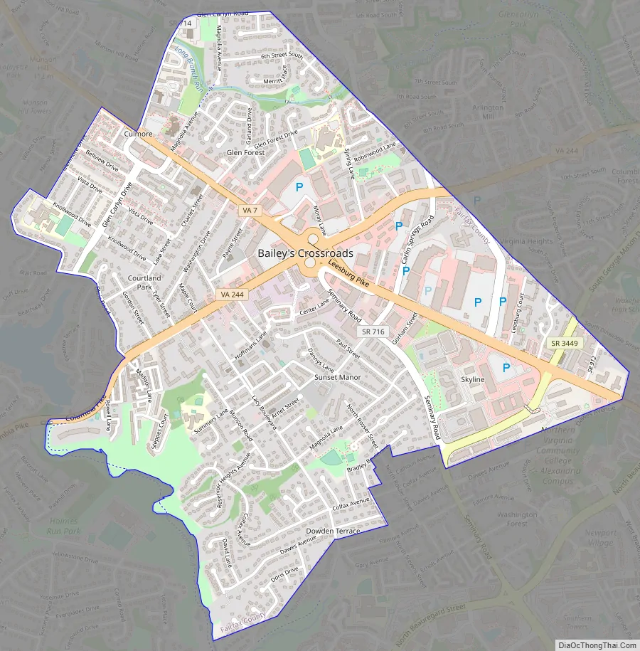
Online Interactive Map
Click on ![]() to view map in "full screen" mode.
to view map in "full screen" mode.
Bailey’s Crossroads location map. Where is Bailey’s Crossroads CDP?
History
Hachaliah Bailey (the founder of one of America’s earliest circuses, which in time evolved into the Bailey component of what became the Ringling Bros. and Barnum & Bailey Circus) moved to Northern Virginia in 1837, bought the land surrounding the intersection of Leesburg Pike and Columbia Pike in Fairfax County, Virginia near Falls Church, Virginia, and gave Bailey’s Crossroads his name. The Crossroads then became the winter quarters for his circus.
Civil War
The opening months of the American Civil War proved to be a disruptive and unforgettable episode in the history of Bailey’s Crossroads. From the summer of 1861, when the area fell into an uncomfortable and poorly defined “no man’s land” between the borders of two warring countries, until late November of that year, when the area hosted a massive troop review, anything akin to normalcy was in short supply.
Virginia voted to secede from the Union on May 23, 1861. Fairfax County’s northern-born residents—many of whom were its most prominent and prosperous citizens—now felt very uncomfortable. Their southern neighbors looked upon them with suspicion. In July 1861 the Union Army met with catastrophic defeat during the First Battle of Manassas. The army retreated all the way to Washington, with the Confederate Army advancing quickly behind it. The Confederates occupied Falls Church and Munson’s Hill, overlooking Bailey’s Crossroads, and the crossroads’ northern-born residents fled for the safety of Washington.
Once Confederates established themselves atop Munson’s Hill they built a crude fort there, and from these commanding heights turned Bailey’s Crossroads into a “killing field”. Southern sharpshooters killed numerous Union soldiers. Violence arose whenever Confederate and Union pickets, or scouts, engaged one another in firefights. It was now impossible to walk the Leesburg Pike without being shot and killed.
There was a minor engagement between the sides on Tuesday, September 3, 1861, with the Union suffering 8 casualties and the Confederates none.
And further, the official reports on the ‘War of the Rebellion’ indicate that during August 28–30, 1861 a series of skirmishes took place at a location scrawled as “Balley’s Cross Roads”.
The local balance of power changed completely—and to everyone’s surprise—on September 28, 1861, as the Confederate Army silently withdrew its forces from Munson’s Hill, Upton’s Hill and Falls Church to Manassas, which they fortified. Munson’s Hill and Falls Church were located too far afield of reliable supply lines, and a concerted Union pincer movement could possibly choke off supplies, the Southern command believed. At Manassas they were adjacent to Virginia’s interior, and had good railroad and road connections to it.
After Confederate withdrawal the area quickly was reoccupied by Union troops. A significant troop review took place at Bailey’s Crossroads on November 20, 1861. Thousands of Union troops marched in formation and paraded before President Abraham Lincoln, the northern press, and many onlookers from Washington. Army commanders selected Bailey’s Crossroads as the site because of its nature as a large, unbroken plain. In order to prepare it for the day’s activities the army merely needed to remove the split-rail fencing separating farms and fields.
During recent years local historians have confused this review with another, smaller review held on nearby Upton’s Hill, where events spurred the composition and publication of the Battle Hymn of the Republic.
Modern era
After the Civil War Bailey’s Crossroads returned to its pastoral pre-war pursuits. The area remained a rural farming community until the post-World War II years, when a massive wave of development occurred. Leesburg Pike is now a commercial corridor, with apartments and homes to its north and south. A strip shopping center called Culmore, in particular, has lent its name to the apartment development behind it, which is now home to several thousand Latino immigrants. “Culmore” is now an established place name within Bailey’s Crossroads. Close behind Culmore is Lake Barcroft, whose shore is lined with upscale middle-class homes.
During the 1960s, as Washington’s Metro system was being conceived, original plans called for a subway line to extend under Columbia Pike to and through Bailey’s Crossroads. As a result of the plan a massive highrise complex was built on the former Washington-Virginia Airport in the heart of Bailey’s Crossroads called Skyline City. Its location coincided with the planned locations of Metro stations. Plans for the Metro, however, changed. The western line was placed along the I-66 corridor instead.
Bailey’s Crossroads Road Map
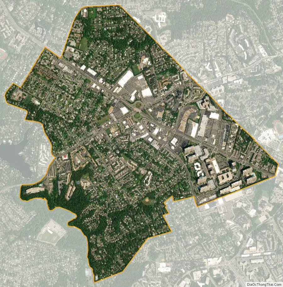
Bailey’s Crossroads city Satellite Map
Geography
Bailey’s Crossroads is located at 38°50′58″N 77°7′45″W / 38.84944°N 77.12917°W / 38.84944; -77.12917 (38.849474, -77.129093).
According to the United States Census Bureau, the CDP has a total area of 2.0 square miles (5.3 km), all of it land. The area occupies a broad, flat plain, bounded on the west by Munson’s Hill. This unbroken expanse of level ground caused the Union Army to select it as the site of a massive review of troops during the Civil War. The review, which took place on November 20, 1861, involved thousands of troops marching in formation and parading before President Abraham Lincoln.
Bailey’s Crossroads is formed by the junction of State Route 7 connecting Alexandria, Virginia with the Shenandoah Valley and State Route 244 (Columbia Pike) connecting the Pentagon and Washington, D.C., with Annandale, Virginia. The most noticeable landmark at Bailey’s Crossroads is Skyline Center, a towering group of 26-story apartment buildings and offices built in the 1970s. A branch of Northern Virginia Community College, and offices of the U.S. Department of Defense are nearby. The neighborhood has a large Hispanic population. The largest single store of the entire Giant Food supermarket chain is also there. While the closest Metrorail station is a few miles away, Metrobus service on the Columbia Pike corridor has recently been improved.
The precise extent of Bailey’s Crossroads has never been defined. As an unincorporated community without local government, it has never had the purview to do so. The United States Census Bureau observes one definition; and various parts of the Fairfax County government observe others. Economic development plans tend to include just the commercial corridors and associated areas. Current discussions among the Fairfax County government for revitalizing Bailey’s Crossroads economically concern themselves with the Fairfax County border on the north and east—which generally includes all commercial and residential properties generally considered as belonging to the neighborhood—as well as Seminary Road and Carlin Spring Road. The plans include a narrow strip along Leesburg Pike to Glen Carlyn Road.
As a general neighborhood, however, with all facets of life included, the geographic extent of Bailey’s Crossroads must be considered to be larger. It abuts the clearly established Lake Barcroft neighborhood on the southwest, with Blair Road, Beachway Drive, Nevius Street and Mansfield Road marking its western proximity. North of Leesburg Pike its extent is generally defined by Glen Carlyn and Carlin Springs roads.
See also
Map of Virginia State and its subdivision:- Accomack
- Albemarle
- Alexandria
- Alleghany
- Amelia
- Amherst
- Appomattox
- Arlington
- Augusta
- Bath
- Bedford
- Bedford City
- Bland
- Botetourt
- Bristol
- Brunswick
- Buchanan
- Buckingham
- Buena Vista
- Campbell
- Caroline
- Carroll
- Charles City
- Charlotte
- Charlottesville
- Chesapeake
- Chesterfield
- Clarke
- Clifton Forge City
- Colonial Heights
- Covington
- Craig
- Culpeper
- Cumberland
- Danville
- Dickenson
- Dinwiddie
- Emporia
- Essex
- Fairfax
- Fairfax City
- Falls Church
- Fauquier
- Floyd
- Fluvanna
- Franklin
- Frederick
- Fredericksburg
- Galax
- Giles
- Gloucester
- Goochland
- Grayson
- Greene
- Greensville
- Halifax
- Hampton
- Hanover
- Harrisonburg
- Henrico
- Henry
- Highland
- Hopewell
- Isle of Wight
- James City
- King and Queen
- King George
- King William
- Lancaster
- Lee
- Lexington
- Loudoun
- Louisa
- Lunenburg
- Lynchburg
- Madison
- Manassas
- Manassas Park
- Martinsville
- Mathews
- Mecklenburg
- Middlesex
- Montgomery
- Nelson
- New Kent
- Newport News
- Norfolk
- Northampton
- Northumberland
- Norton
- Nottoway
- Orange
- Page
- Patrick
- Petersburg
- Pittsylvania
- Poquoson
- Portsmouth
- Powhatan
- Prince Edward
- Prince George
- Prince William
- Pulaski
- Radford
- Rappahannock
- Richmond
- Roanoke
- Roanoke City
- Rockbridge
- Rockingham
- Russell
- Salem
- Scott
- Shenandoah
- Smyth
- Southampton
- Spotsylvania
- Stafford
- Staunton
- Suffolk
- Surry
- Sussex
- Tazewell
- Virginia Beach
- Warren
- Washington
- Waynesboro
- Westmoreland
- Williamsburg
- Winchester
- Wise
- Wythe
- York
- Alabama
- Alaska
- Arizona
- Arkansas
- California
- Colorado
- Connecticut
- Delaware
- District of Columbia
- Florida
- Georgia
- Hawaii
- Idaho
- Illinois
- Indiana
- Iowa
- Kansas
- Kentucky
- Louisiana
- Maine
- Maryland
- Massachusetts
- Michigan
- Minnesota
- Mississippi
- Missouri
- Montana
- Nebraska
- Nevada
- New Hampshire
- New Jersey
- New Mexico
- New York
- North Carolina
- North Dakota
- Ohio
- Oklahoma
- Oregon
- Pennsylvania
- Rhode Island
- South Carolina
- South Dakota
- Tennessee
- Texas
- Utah
- Vermont
- Virginia
- Washington
- West Virginia
- Wisconsin
- Wyoming


