Springfield is a census-designated place (CDP) in Fairfax County, Virginia, United States. The Springfield CDP is recognized by the U.S. Census Bureau with a population of 30,484 as of the 2010 census. Homes and businesses in bordering CDPs including North Springfield, West Springfield, and Newington are usually given a Springfield mailing address. The population of the collective areas with Springfield addresses is estimated to exceed 100,000. The CDP is a part of Northern Virginia, the most populous region of the Washington Metropolitan Area.
| Name: | Springfield CDP |
|---|---|
| LSAD Code: | 57 |
| LSAD Description: | CDP (suffix) |
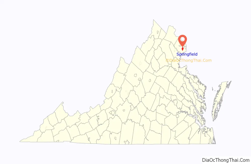
| State: | Virginia |
| County: | Fairfax County |
| Elevation: | 246 ft (75 m) |
| Total Area: | 7.9 sq mi (20.4 km²) |
| Land Area: | 7.9 sq mi (20.3 km²) |
| Water Area: | 0.0 sq mi (0.1 km²) |
| Total Population: | 31,339 |
| Population Density: | 3,966.9/sq mi (1,536.2/km²) |
| Area code: | 703, 571 |
| FIPS code: | 5174592 |
| GNISfeature ID: | 1493642 |
Online Interactive Map
Click on ![]() to view map in "full screen" mode.
to view map in "full screen" mode.
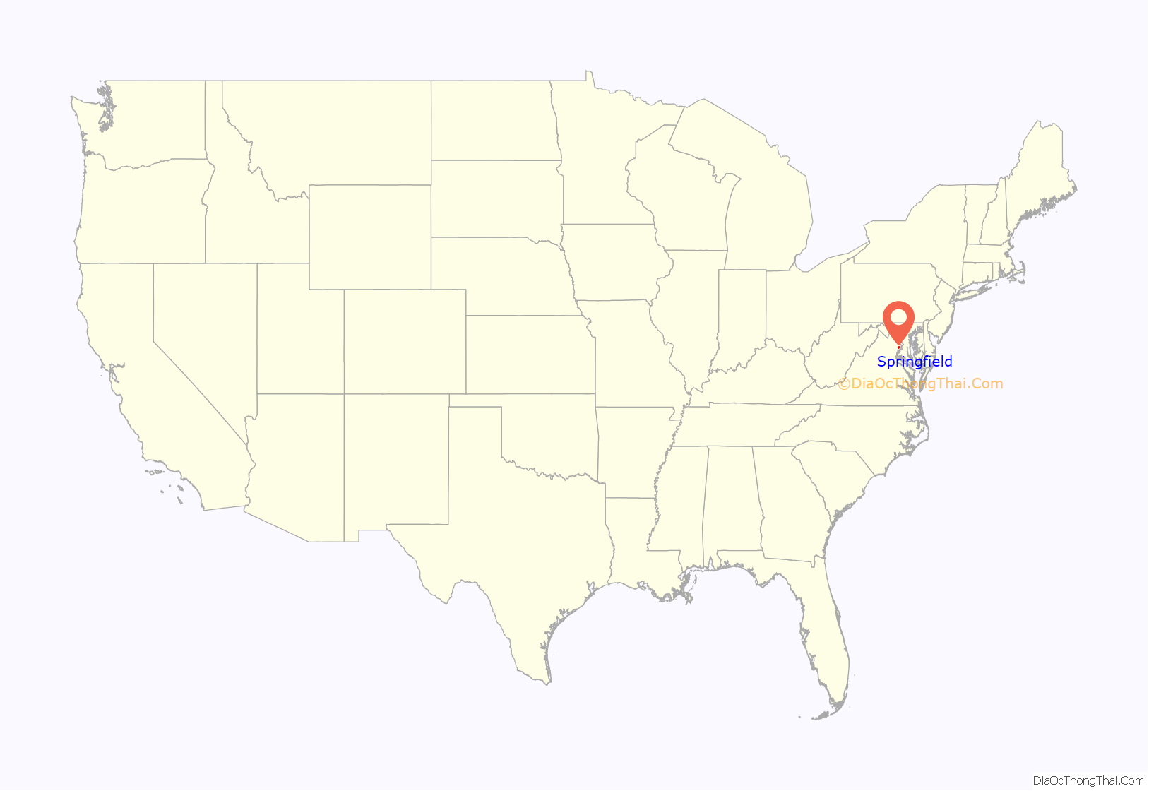
Springfield location map. Where is Springfield CDP?
History
A saw and grist mill was constructed in the vicinity of what is today Springfield between 1796 and 1800. Owned by James Keene, it gave its name to today’s Old Keene Mill Road. The mill served farms in the area for around sixty years before its discontinuation when William H. Keene was convicted and imprisoned for the 1855 murder of Lewis Quincy Hall. Nothing remains of it today save for two mill races.
Springfield was founded in 1847 around the Orange and Alexandria Railroad’s Daingerfield Station; this is today the Backlick Road Virginia Railway Express station, located off Backlick Road. The area was named for “Springfield Farm”, owned by Henry Daingerfield, an Alexandria businessman who sat on the railroad’s board of directors. The post office was completed sometime after 1851. It was in existence at the time of the American Civil War, being the site of a skirmish on October 3, 1861 and a Confederate raid on August 3, 1863. The station served as the first Springfield Post Office from 1866 to 1868.
In 1877, Richard Moore petitioned for a post office, which he named Moor; it was located about a little over a mile south of the station, near the intersection of Fairfax (now Old Keene Mill) and Backlick roads. The post office name was changed in 1881 to Garfield to honor the late President James A. Garfield, who had been assassinated that year. In 1907, the Garfield post office closed and a new postal station named Corbett (after the then-landowner) opened back at the railroad station. The name “Springfield” was reinstated for good on June 27, 1910, although the name Garfield continued to appear on maps at least through the 1930s. The post office was moved to a new site in 1933.
Springfield remained a rural crossroads until 1946, when real estate developer Edward Carr decided to subdivide the area for suburban development along the recently opened Henry Shirley Highway (now I-95/I-395). Carr believed this to be the last easily accessible tract within 12 miles (19 km) of Washington, D.C., and indeed, the newly developed area grew quickly. In 1950, the area had an estimated population of 1,000; Robert E. Lee High School was built in 1957. By 1960, the population was reported as over 10,000; it grew past 25,000 by 1970 with the North and West Springfield neighborhoods.
Springfield became a major retail destination with the opening of the Springfield Mall (now Springfield Town Center) in 1973–75 (the second regional shopping center in Northern Virginia after Tysons Corner), as well as the Springfield and Brookfield shopping centers. The 1980s and 1990s saw the expansion of retail and high-density housing in the area, at least until the opening of the Franconia-Springfield Parkway in 1996, and the Franconia-Springfield Metro and Virginia Rail Express Station in 1997. The mall was renovated and re-opened in 2014.
The center of Springfield is at Route 644 (Old Keene Mill Road / Franconia Road) and Route 617. The old “Garfield” name still survives in the nearby Garfield Elementary School.
The Sydenstricker School, completed in 1928, was listed on the National Register of Historic Places in 2012.
Demographics
As of the census of 2010, there were 30,484 people, 12,431 houses, and 7,472 families residing in the Springfield CDP. The population density was 3,869.5 inhabitants per square mile (1,494.0/km). There were 10,630 housing units at an average density of 1,345.6 per square mile (519.5/km). The racial makeup of the CDP was 48.7% White, 9.0% African American, 0.7% Native American, 24.3% Asian, 0.1% Pacific Islander, 12.5% from other races, and 4.7% from two or more races. Hispanic or Latino of any race were 25.5% of the population.
As of 2000, there were 10,495 households, out of which 32.9% had children under the age of 18 living with them, 58.0% were married couples living together, 8.9% had a female householder with no husband present, and 28.8% were non-families. 22.1% of all households were made up of individuals, and 7.7% had someone living alone who was 65 years of age or older. The average household size was 2.88 and the average family size was 3.37. As of 2010, the average household size was 2.82.
In the Springfield CDP, the population was spread out, with 22.5% under the age of 18, 8.0% from 18 to 24, 34.2% from 25 to 44, 23.2% from 45 to 64, and 11.2% who were 65 years of age or older. The median age was 36 years. For every 100 females, there were 99.2 males. For every 100 females age 18 and over, there were 96.5 males.
The median income for a household in the Springfield CDP as of 2010 was $84,309, and the median income for a family was $95,158. In 2000, males had a median income of $45,679 versus $36,075 for females. The per capita income for the CDP was $36,405.
The zip code population totals for the entire Springfield community (as defined by USPS) were as follows:
- 22150: 22,208
- 22151: 16,587
- 22152: 28,236
- 22153: 33,177
- Total: 100,208
Public safety
The Greater Springfield Volunteer Fire Department’s fire station at 7011 Backlick Road provides fire and EMS services to Springfield.
The West Springfield District Police Station of the Fairfax County Police Department is at 6140 Rolling Road.
Shopping
Springfield Mall was a large indoor shopping mall near the Springfield Interchange, the intersection of Interstate highways I-95 and I-495. It contained several anchor stores and a food court. In 2001, two of the hijackers in the September 11 attacks, Hani Hanjour and Khalid al-Mihdhar, illegally obtained state identification at the mall’s DMV office. In 2005, gang members stabbed two people at the mall. and a fatal shooting occurred in December 2007.
In 2005, the mall was purchased by Vornado Realty Trust, which closed the structure, renovated and reopened it in 2014 as “Springfield Town Center”.
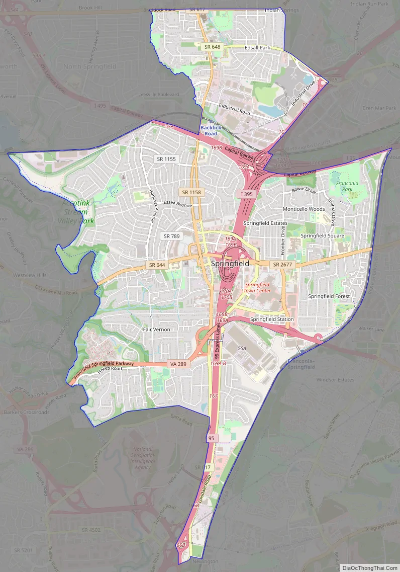
Springfield Road Map
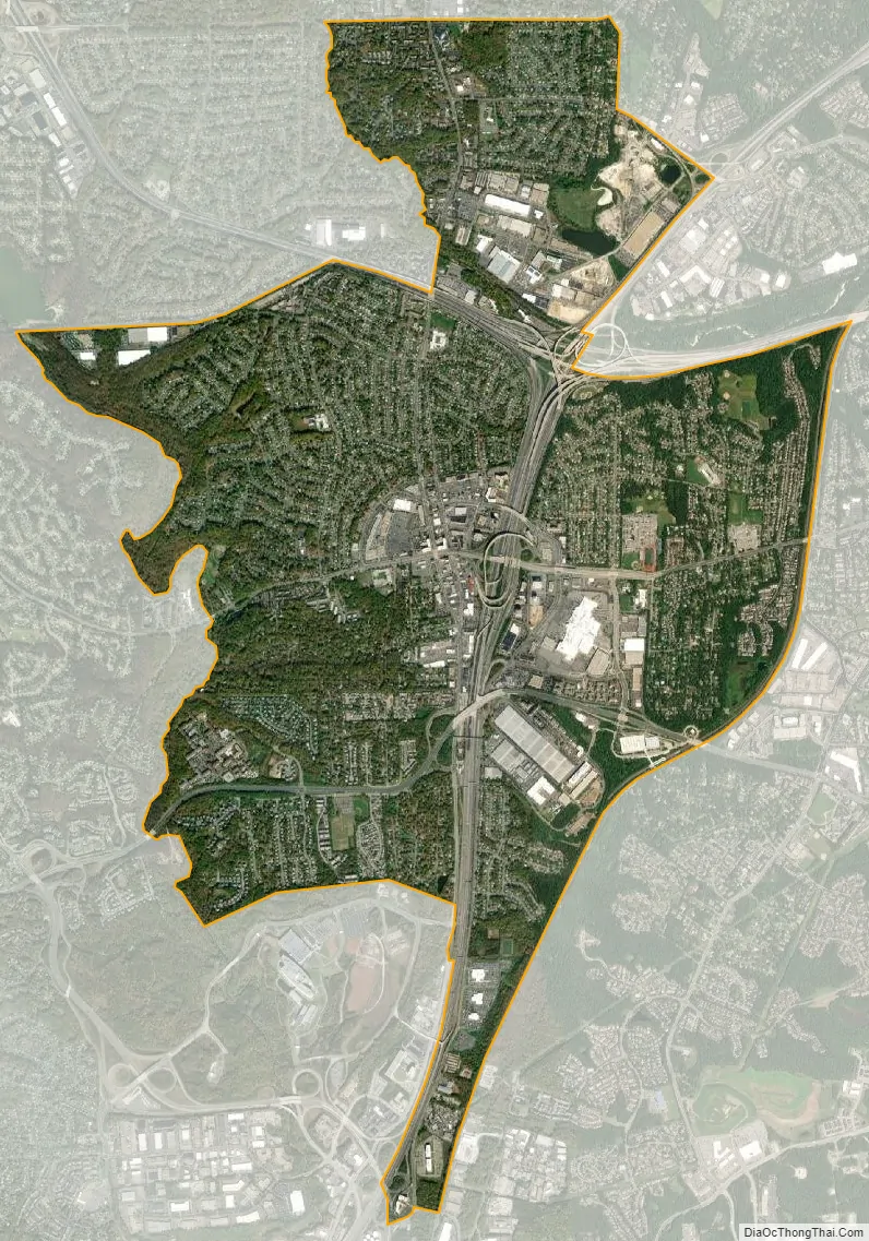
Springfield city Satellite Map
Geography
Springfield is located at 38°46′45″N 77°11′4″W / 38.77917°N 77.18444°W / 38.77917; -77.18444 (38.779238, −77.184636).
According to the United States Census Bureau, the CDP has a total area of 7.9 square miles (20.4 km), of which, 7.9 square miles (20.3 km) of it is land and 0.04 square miles (0.1 km) of it (0.49%) is water.
The area is dominated by the interchange of I-95, I-395, and the Capital Beltway (I-495), known as the Springfield Interchange. The center of the town is at the intersection of Route 644 (Old Keene Mill Road / Franconia Road) and Route 617 (Backlick Road) adjacent to the interchange. A significant commercial district exists around the interchange area, but the rest of the community is primarily residential in character.
According to the U.S. Postal Service, Springfield collectively has four ZIP codes:
- 22150 (often unofficially referred to as Central Springfield, this is the zip code for the actual Springfield CDP itself.)
- 22151 (North Springfield)
- 22152 (West Springfield)
- 22153 (Newington)
The following are total area, water area, and land area statistics (in square miles) for the four Springfield zip codes:
See also
Map of Virginia State and its subdivision:- Accomack
- Albemarle
- Alexandria
- Alleghany
- Amelia
- Amherst
- Appomattox
- Arlington
- Augusta
- Bath
- Bedford
- Bedford City
- Bland
- Botetourt
- Bristol
- Brunswick
- Buchanan
- Buckingham
- Buena Vista
- Campbell
- Caroline
- Carroll
- Charles City
- Charlotte
- Charlottesville
- Chesapeake
- Chesterfield
- Clarke
- Clifton Forge City
- Colonial Heights
- Covington
- Craig
- Culpeper
- Cumberland
- Danville
- Dickenson
- Dinwiddie
- Emporia
- Essex
- Fairfax
- Fairfax City
- Falls Church
- Fauquier
- Floyd
- Fluvanna
- Franklin
- Frederick
- Fredericksburg
- Galax
- Giles
- Gloucester
- Goochland
- Grayson
- Greene
- Greensville
- Halifax
- Hampton
- Hanover
- Harrisonburg
- Henrico
- Henry
- Highland
- Hopewell
- Isle of Wight
- James City
- King and Queen
- King George
- King William
- Lancaster
- Lee
- Lexington
- Loudoun
- Louisa
- Lunenburg
- Lynchburg
- Madison
- Manassas
- Manassas Park
- Martinsville
- Mathews
- Mecklenburg
- Middlesex
- Montgomery
- Nelson
- New Kent
- Newport News
- Norfolk
- Northampton
- Northumberland
- Norton
- Nottoway
- Orange
- Page
- Patrick
- Petersburg
- Pittsylvania
- Poquoson
- Portsmouth
- Powhatan
- Prince Edward
- Prince George
- Prince William
- Pulaski
- Radford
- Rappahannock
- Richmond
- Roanoke
- Roanoke City
- Rockbridge
- Rockingham
- Russell
- Salem
- Scott
- Shenandoah
- Smyth
- Southampton
- Spotsylvania
- Stafford
- Staunton
- Suffolk
- Surry
- Sussex
- Tazewell
- Virginia Beach
- Warren
- Washington
- Waynesboro
- Westmoreland
- Williamsburg
- Winchester
- Wise
- Wythe
- York
- Alabama
- Alaska
- Arizona
- Arkansas
- California
- Colorado
- Connecticut
- Delaware
- District of Columbia
- Florida
- Georgia
- Hawaii
- Idaho
- Illinois
- Indiana
- Iowa
- Kansas
- Kentucky
- Louisiana
- Maine
- Maryland
- Massachusetts
- Michigan
- Minnesota
- Mississippi
- Missouri
- Montana
- Nebraska
- Nevada
- New Hampshire
- New Jersey
- New Mexico
- New York
- North Carolina
- North Dakota
- Ohio
- Oklahoma
- Oregon
- Pennsylvania
- Rhode Island
- South Carolina
- South Dakota
- Tennessee
- Texas
- Utah
- Vermont
- Virginia
- Washington
- West Virginia
- Wisconsin
- Wyoming


