Vienna (/viˈɛnə/) is a town in Fairfax County, Virginia, United States. As of the 2020 U.S. census, Vienna has a population of 16,473. Significantly more people live in ZIP codes with the Vienna postal addresses (22180, 22181, and 22182), bordered approximately by Interstate 66 on the south, Interstate 495 on the east, Route 7 to the north, and Hunter Mill Road to the west, than in the town itself.
| Name: | Vienna town |
|---|---|
| LSAD Code: | 43 |
| LSAD Description: | town (suffix) |
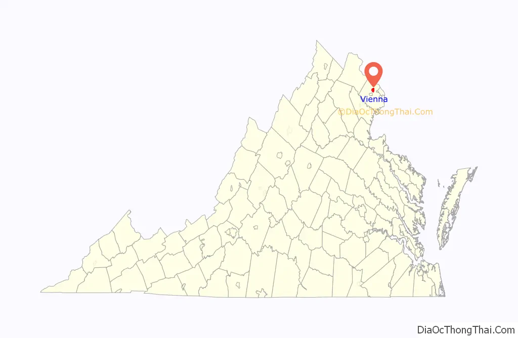
| State: | Virginia |
| County: | Fairfax County |
| Incorporated: | 1890 |
| Elevation: | 358 ft (109 m) |
| Total Area: | 4.41 sq mi (11.42 km²) |
| Land Area: | 4.40 sq mi (11.40 km²) |
| Water Area: | 0.01 sq mi (0.02 km²) |
| Total Population: | 16,473 |
| Population Density: | 3,741.3/sq mi (1,451.69/km²) |
| ZIP code: | 22180-22183, 22185 |
| Area code: | 571 and 703 |
| FIPS code: | 5181072 |
| GNISfeature ID: | 1500258 |
| Website: | www.viennava.gov |
Online Interactive Map
Click on ![]() to view map in "full screen" mode.
to view map in "full screen" mode.
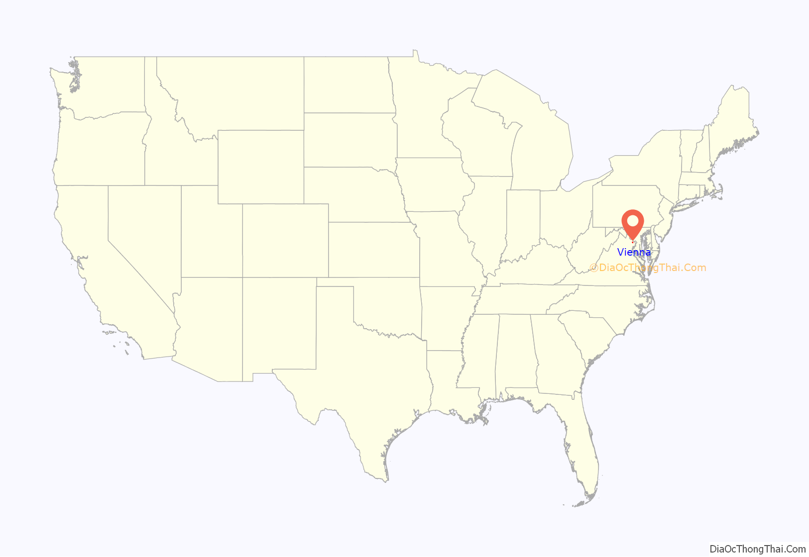
Vienna location map. Where is Vienna town?
History
Non-native settlement in the region dates to c. 1740. In 1754, prominent soldier and land owner Colonel Charles Broadwater settled within the town boundaries. Broadwater’s son-in-law, John Hunter built the first recorded house there in 1767, naming it Ayr Hill to recall his birthplace, Ayr, Scotland. That name was then applied to the tiny developing community. The name of the town was changed in the 1850s, when a doctor, William Hendrick, settled there if the town renamed itself after his hometown, Phelps, New York, which was then known as Vienna.
On June 17, 1861, a relatively-minor but widely noted military engagement occurred there, the Battle of Vienna, one of the earliest armed clashes of the American Civil War. A would-be Union occupation unit under Brigadier General Robert C. Schenck approached Vienna from the east by train but was ambushed and forced to retreat by a superior Confederate force led by Colonel Maxcy Gregg. Today, several historical markers in Vienna detail its Civil War history. In addition, in the center of town lies the well preserved Freeman House; which, in 1861, was the polling place for the secession vote and was used during the war by both sides as a hospital. The house has been turned into a museum and gift shop.
The First Baptist Church of Vienna was founded in 1867, and the original church structure was built using Union Army barracks lumber obtained through the Freedmen’s Bureau. This church building was also the town’s first black public school. The first white public school was built in 1872. A permanent black elementary school was built, which was later named for its long-time principal, Louise Archer. Fairfax County Schools were completely desegregated by the Fall of 1965.
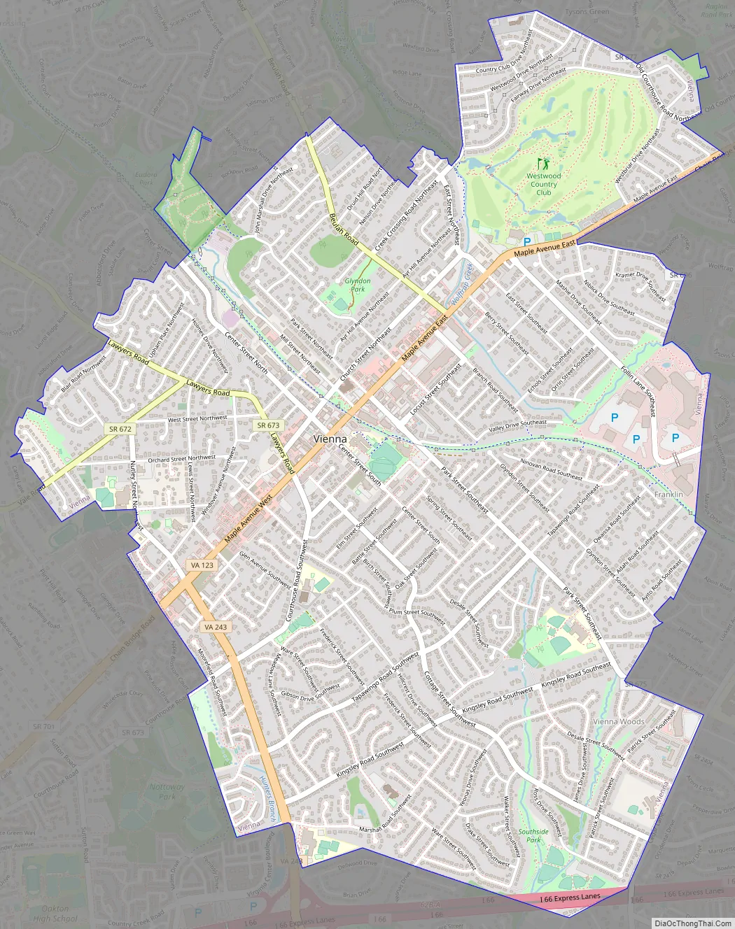
Vienna Road Map
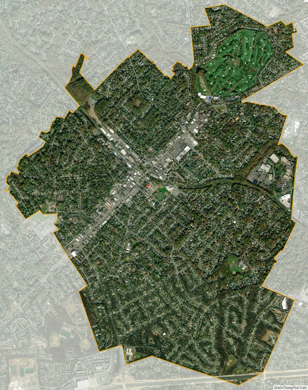
Vienna city Satellite Map
Geography
Vienna is located at 38°54′N 77°16′W / 38.900°N 77.267°W / 38.900; -77.267 (38.8991, −77.2607), at an elevation of 358 feet (109 meters). It lies in the Piedmont approximately 5.5 miles (8.9 km) southwest of the Potomac River. Wolftrap Creek, a tributary of nearby Difficult Run, flows north from its source in the eastern part of town. The Bear Branch of Accotink Creek, a Potomac tributary, flows south from its source in the southern part of town. Located in Northern Virginia on Interstate 66, Vienna is 12 miles (19 km) west of Washington, D.C. and 2 miles (3.2 km) northeast of Fairfax, the county seat.
According to the United States Census Bureau, the town has a total area of 4.4 square miles (11 km), all of it land. As a suburb of Washington, D.C., Vienna is a part of both the Washington metropolitan area and the larger Washington–Baltimore combined statistical area. It is bordered on all sides by other Washington suburbs, including: Wolf Trap to the north, Tysons Corner to the northeast, Dunn Loring to the east, Merrifield to the south, and Oakton to the west. These communities are unincorporated, and portions of them lie in ZIP codes with Vienna postal addresses despite lying outside the town’s borders.
See also
Map of Virginia State and its subdivision:- Accomack
- Albemarle
- Alexandria
- Alleghany
- Amelia
- Amherst
- Appomattox
- Arlington
- Augusta
- Bath
- Bedford
- Bedford City
- Bland
- Botetourt
- Bristol
- Brunswick
- Buchanan
- Buckingham
- Buena Vista
- Campbell
- Caroline
- Carroll
- Charles City
- Charlotte
- Charlottesville
- Chesapeake
- Chesterfield
- Clarke
- Clifton Forge City
- Colonial Heights
- Covington
- Craig
- Culpeper
- Cumberland
- Danville
- Dickenson
- Dinwiddie
- Emporia
- Essex
- Fairfax
- Fairfax City
- Falls Church
- Fauquier
- Floyd
- Fluvanna
- Franklin
- Frederick
- Fredericksburg
- Galax
- Giles
- Gloucester
- Goochland
- Grayson
- Greene
- Greensville
- Halifax
- Hampton
- Hanover
- Harrisonburg
- Henrico
- Henry
- Highland
- Hopewell
- Isle of Wight
- James City
- King and Queen
- King George
- King William
- Lancaster
- Lee
- Lexington
- Loudoun
- Louisa
- Lunenburg
- Lynchburg
- Madison
- Manassas
- Manassas Park
- Martinsville
- Mathews
- Mecklenburg
- Middlesex
- Montgomery
- Nelson
- New Kent
- Newport News
- Norfolk
- Northampton
- Northumberland
- Norton
- Nottoway
- Orange
- Page
- Patrick
- Petersburg
- Pittsylvania
- Poquoson
- Portsmouth
- Powhatan
- Prince Edward
- Prince George
- Prince William
- Pulaski
- Radford
- Rappahannock
- Richmond
- Roanoke
- Roanoke City
- Rockbridge
- Rockingham
- Russell
- Salem
- Scott
- Shenandoah
- Smyth
- Southampton
- Spotsylvania
- Stafford
- Staunton
- Suffolk
- Surry
- Sussex
- Tazewell
- Virginia Beach
- Warren
- Washington
- Waynesboro
- Westmoreland
- Williamsburg
- Winchester
- Wise
- Wythe
- York
- Alabama
- Alaska
- Arizona
- Arkansas
- California
- Colorado
- Connecticut
- Delaware
- District of Columbia
- Florida
- Georgia
- Hawaii
- Idaho
- Illinois
- Indiana
- Iowa
- Kansas
- Kentucky
- Louisiana
- Maine
- Maryland
- Massachusetts
- Michigan
- Minnesota
- Mississippi
- Missouri
- Montana
- Nebraska
- Nevada
- New Hampshire
- New Jersey
- New Mexico
- New York
- North Carolina
- North Dakota
- Ohio
- Oklahoma
- Oregon
- Pennsylvania
- Rhode Island
- South Carolina
- South Dakota
- Tennessee
- Texas
- Utah
- Vermont
- Virginia
- Washington
- West Virginia
- Wisconsin
- Wyoming


