Cascades is a census-designated place (CDP) in Loudoun County, Virginia, United States. The population as of the 2010 United States Census was 11,912. Along with nearby Countryside and Lowes Island, it is considered one of the three main components of the Potomac Falls community (ZIP code 20165) within Sterling, Virginia.
Cascades is a planned community of 2,500 acres (1,000 ha) with approximately 6,500 homes. The corresponding homeowners association was incorporated on November 8, 1990. As in nearby Sterling Park, prior to the establishment of the Cascades community in 1990 the area was made up of a few very large farms. The homeowners association maintains five community centers, five swimming pools, 15 tennis courts, and other amenities including extensive paved walking trails. The Lowes Island at Cascades community (commonly referred to as Lowes Island) is an advertised portion of the legal subdivision of Cascades, but is not a legal subdivision itself. The Lowes Island community is centered on Trump National Golf Club Washington, D.C., formerly Lowes Island Country Club. The Cascades development is bordered on the north by the Potomack Lake Sportsplex and Algonkian Regional Park (which abuts the Potomac River); both facilities are included in the Cascades census-designated place. The name “Cascades” alludes to the rapidly descending flow along the Potomac River starting at Lowes Island and leading to Great Falls.
The commercial core of Cascades is Cascades Marketplace, a 318,000-square-foot (29,500 m) retail center adjacent to the Cascades Public Library and very near the Loudoun campus of Northern Virginia Community College. Great Falls Plaza is a second, smaller retail center located just outside Lowes Island. Area public schools include Potomac Falls High School, River Bend Middle School, Potowmack Elementary School, Horizon Elementary School, and Lowes Island Elementary School. The Cascades area encompasses the gated campus of the Falcons Landing retirement community for retired U.S. military officers. Cascades is served by Loudoun County Sheriff’s Office, the Sterling Volunteer Fire Department, and the Potomac Falls post office.
The entrance to the Cascades community along Cascades Parkway at Palisade Parkway. The Cascades logo can be seen in the lower right.
Leaving Cascades along Cascades Parkway toward Virginia State Route 7
The main office of the Cascades homeowners association
Stone House, one of five community centers in Cascades
One of many paved walking trails in Cascades
One corner of the Cascades Marketplace
Cascades Public Library as seen from Cascades Marketplace
The Cascades fire station of the Sterling Volunteer Fire Department
Great Falls Plaza, a retail center located to the east in the Lowes Island CDP
The entrance to the Lowes Island subdivision
The Potomack Sportsplex, just outside the entrance to Algonkian Regional Park
The entrance to Algonkian Regional Park
The Potomac River at Algonkian Regional Park
The Potomac River descends along the northern edge of the Cascades community until it reaches Great Falls Park 8 miles (13 km) downstream.
| Name: | Cascades CDP |
|---|---|
| LSAD Code: | 57 |
| LSAD Description: | CDP (suffix) |
| State: | Virginia |
| County: | Loudoun County |
| Elevation: | 270 ft (80 m) |
| Total Area: | 3.75 sq mi (9.71 km²) |
| Land Area: | 3.69 sq mi (9.55 km²) |
| Water Area: | 0.06 sq mi (0.16 km²) |
| Total Population: | 11,912 |
| Population Density: | 3,232/sq mi (1,247.8/km²) |
| ZIP code: | 20165 |
| Area code: | 703 and 571 |
| FIPS code: | 5113403 |
| GNISfeature ID: | 2584825 |
Online Interactive Map
Click on ![]() to view map in "full screen" mode.
to view map in "full screen" mode.
Cascades location map. Where is Cascades CDP?


Cascades Road Map

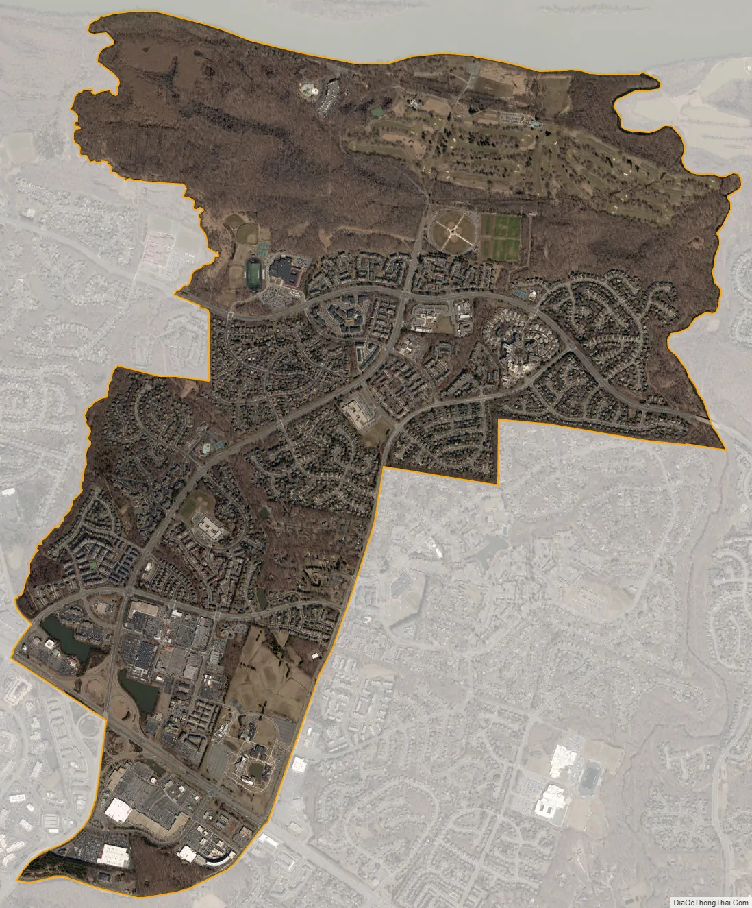
Cascades city Satellite Map
See also
Map of Virginia State and its subdivision:- Accomack
- Albemarle
- Alexandria
- Alleghany
- Amelia
- Amherst
- Appomattox
- Arlington
- Augusta
- Bath
- Bedford
- Bedford City
- Bland
- Botetourt
- Bristol
- Brunswick
- Buchanan
- Buckingham
- Buena Vista
- Campbell
- Caroline
- Carroll
- Charles City
- Charlotte
- Charlottesville
- Chesapeake
- Chesterfield
- Clarke
- Clifton Forge City
- Colonial Heights
- Covington
- Craig
- Culpeper
- Cumberland
- Danville
- Dickenson
- Dinwiddie
- Emporia
- Essex
- Fairfax
- Fairfax City
- Falls Church
- Fauquier
- Floyd
- Fluvanna
- Franklin
- Frederick
- Fredericksburg
- Galax
- Giles
- Gloucester
- Goochland
- Grayson
- Greene
- Greensville
- Halifax
- Hampton
- Hanover
- Harrisonburg
- Henrico
- Henry
- Highland
- Hopewell
- Isle of Wight
- James City
- King and Queen
- King George
- King William
- Lancaster
- Lee
- Lexington
- Loudoun
- Louisa
- Lunenburg
- Lynchburg
- Madison
- Manassas
- Manassas Park
- Martinsville
- Mathews
- Mecklenburg
- Middlesex
- Montgomery
- Nelson
- New Kent
- Newport News
- Norfolk
- Northampton
- Northumberland
- Norton
- Nottoway
- Orange
- Page
- Patrick
- Petersburg
- Pittsylvania
- Poquoson
- Portsmouth
- Powhatan
- Prince Edward
- Prince George
- Prince William
- Pulaski
- Radford
- Rappahannock
- Richmond
- Roanoke
- Roanoke City
- Rockbridge
- Rockingham
- Russell
- Salem
- Scott
- Shenandoah
- Smyth
- Southampton
- Spotsylvania
- Stafford
- Staunton
- Suffolk
- Surry
- Sussex
- Tazewell
- Virginia Beach
- Warren
- Washington
- Waynesboro
- Westmoreland
- Williamsburg
- Winchester
- Wise
- Wythe
- York
- Alabama
- Alaska
- Arizona
- Arkansas
- California
- Colorado
- Connecticut
- Delaware
- District of Columbia
- Florida
- Georgia
- Hawaii
- Idaho
- Illinois
- Indiana
- Iowa
- Kansas
- Kentucky
- Louisiana
- Maine
- Maryland
- Massachusetts
- Michigan
- Minnesota
- Mississippi
- Missouri
- Montana
- Nebraska
- Nevada
- New Hampshire
- New Jersey
- New Mexico
- New York
- North Carolina
- North Dakota
- Ohio
- Oklahoma
- Oregon
- Pennsylvania
- Rhode Island
- South Carolina
- South Dakota
- Tennessee
- Texas
- Utah
- Vermont
- Virginia
- Washington
- West Virginia
- Wisconsin
- Wyoming