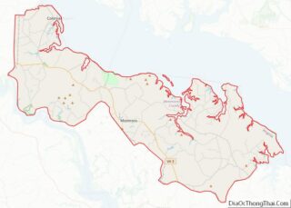
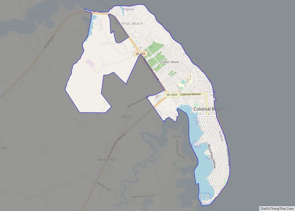
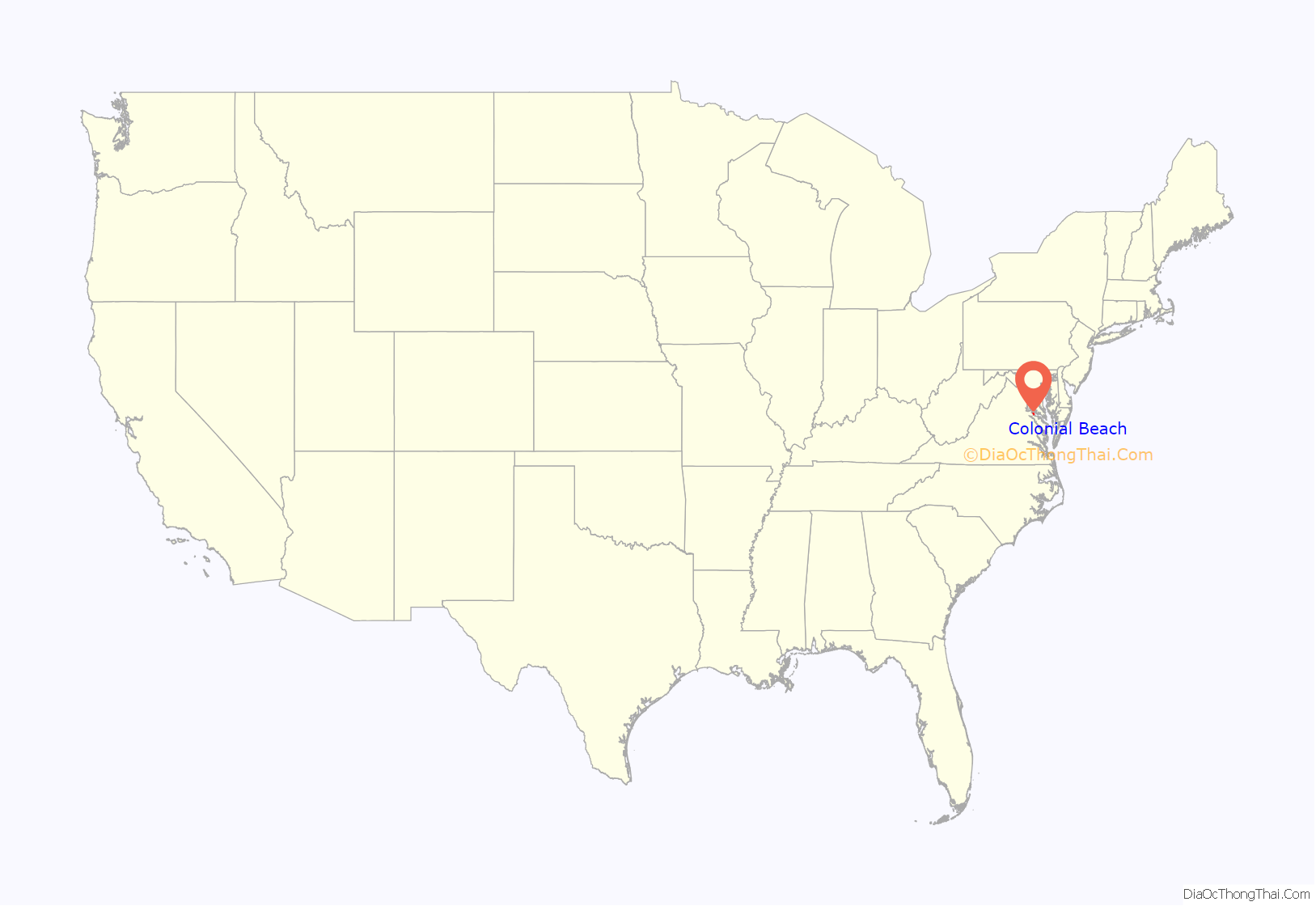
Colonial Beach, Virginia (CBVA) is a river and beach town located in the northwestern part of Westmoreland County on Virginia‘s Northern Neck peninsula. It is bounded by the Potomac River, Monroe Bay and Monroe Creek. It is located 65 mi (105 km) from Washington, D.C.; 70 mi (110 km) from the state capital of Richmond; and 35 nautical miles from the Chesapeake Bay.
Colonial Beach was named Best Virginia Beach for 2018 by USA Today. In 2019, Colonial Beach was named The Nicest Place in Virginia and a finalist for Nicest Places in America by Reader’s Digest.
Colonial Beach was a popular resort town in the early to mid-20th century, before the Chesapeake Bay Bridge made ocean beaches on the Eastern Shore of Maryland more accessible to visitors from Washington, D.C. The family of Alexander Graham Bell maintained a summer home in Colonial Beach, the Bell House, which still stands today. Sloan Wilson, author of The Man in the Gray Flannel Suit, retired and died in Colonial Beach. George Washington, the first President of the United States, was born near here at what is now the George Washington Birthplace National Monument. As of 2011, the James Monroe Family Home Site, birthplace of President James Monroe, now has a small monument to him.
| Name: | Colonial Beach town |
|---|---|
| LSAD Code: | 43 |
| LSAD Description: | town (suffix) |
| State: | Virginia |
| County: | Westmoreland County |
| Founded: | 1892 |
| Elevation: | 10 ft (3 m) |
| Total Area: | 2.78 sq mi (7.21 km²) |
| Land Area: | 2.45 sq mi (6.34 km²) |
| Water Area: | 0.33 sq mi (0.86 km²) |
| Total Population: | 3,542 |
| Population Density: | 1,478.35/sq mi (570.72/km²) |
| ZIP code: | 22443 |
| Area code: | 804 |
| FIPS code: | 5118400 |
| GNISfeature ID: | 1493549 |
| Website: | http://www.colonialbeachva.net/ |
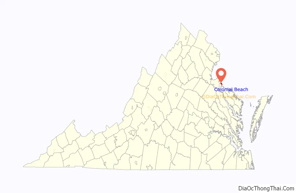
Online Interactive Map
Click on ![]() to view map in "full screen" mode.
to view map in "full screen" mode.
Colonial Beach location map. Where is Colonial Beach town?
History
Judging by excavations done on oyster pits, it would seem that Native Americans have inhabited the area of modern-day Colonial Beach since at least the Early Woodland Period (500 B.C.- A.D. 900).
The town area now known as ‘The Point’ was originally patented by John Lancelott and S. Lancelott [Odyer and Sturman Escheat] on October 29, 1651.
Colonial Beach emerged as a bathing and fishing resort in the late 19th century known as the “Playground on the Potomac.” Prior to automobile travel, most visitors arrived by boat from Washington, D.C.
The town was incorporated on February 25, 1892, and there was extensive construction of houses, summer cottages, and hotels. Arguably the most famous of these structures is the Bell House, built for Alexander Graham Bell as a summer home, which still stands today on Irving Avenue.
The area was at the center of the Potomac River Oyster Wars between Virginia watermen and the Maryland State Oyster Police that lasted from the late 19th century to the 1960s.
The town began to gradually decline as the automobile made travel to more distant ocean beaches more feasible. However, because gambling was legal in Maryland and the Maryland state line ends at the low-water mark of Virginia’s Potomac River shore, from 1949 to 1958, Colonial Beach offered slot machines in pier casinos extending into Maryland waters. This temporarily revitalized the town, although it was sometimes called “the poor man’s Las Vegas.” However, the piers burned in the 1960s in a devastating fire and the town continued to decline.
The town is ranked fifth-safest place to live in Virginia by Safewise.
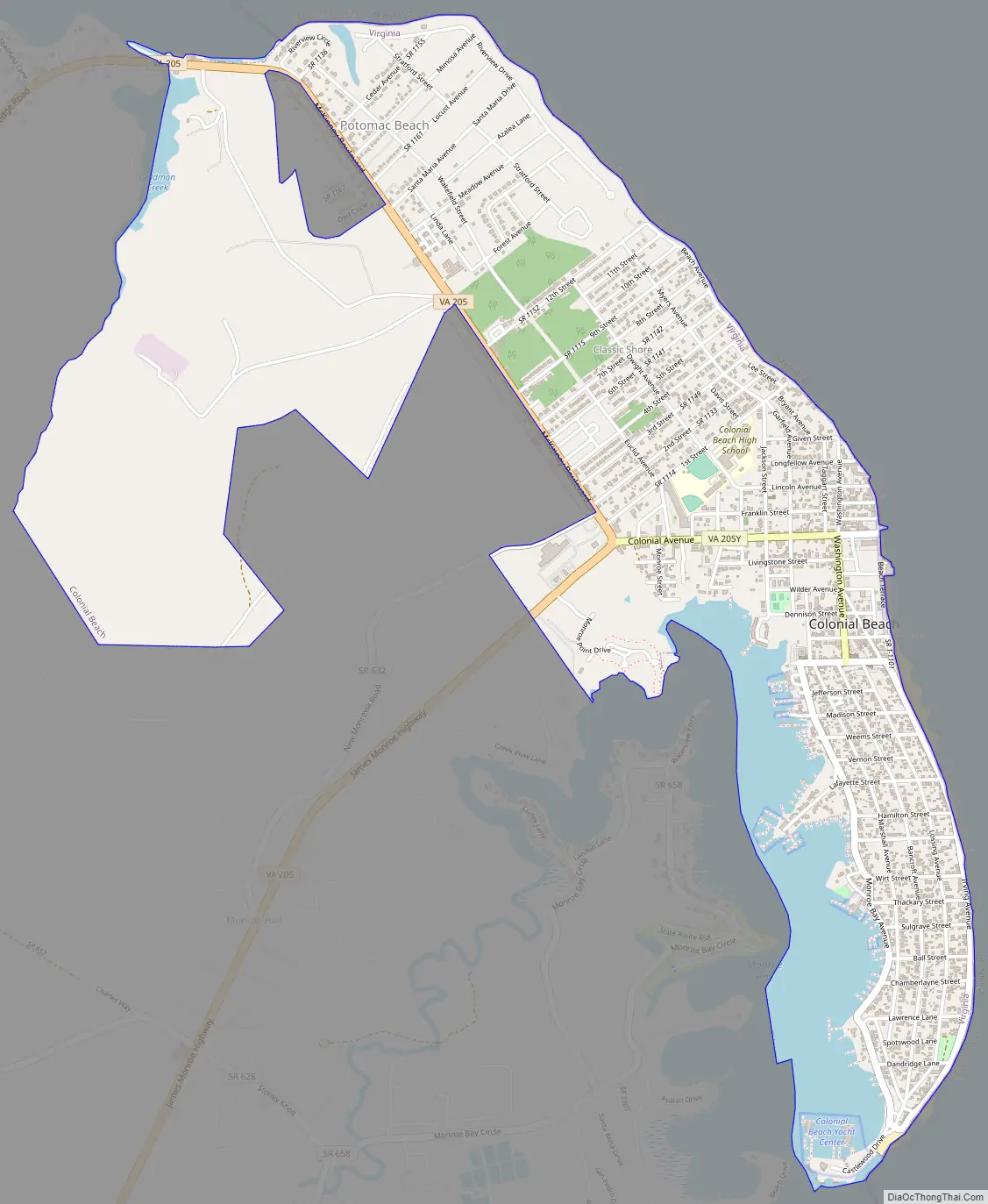
Colonial Beach Road Map
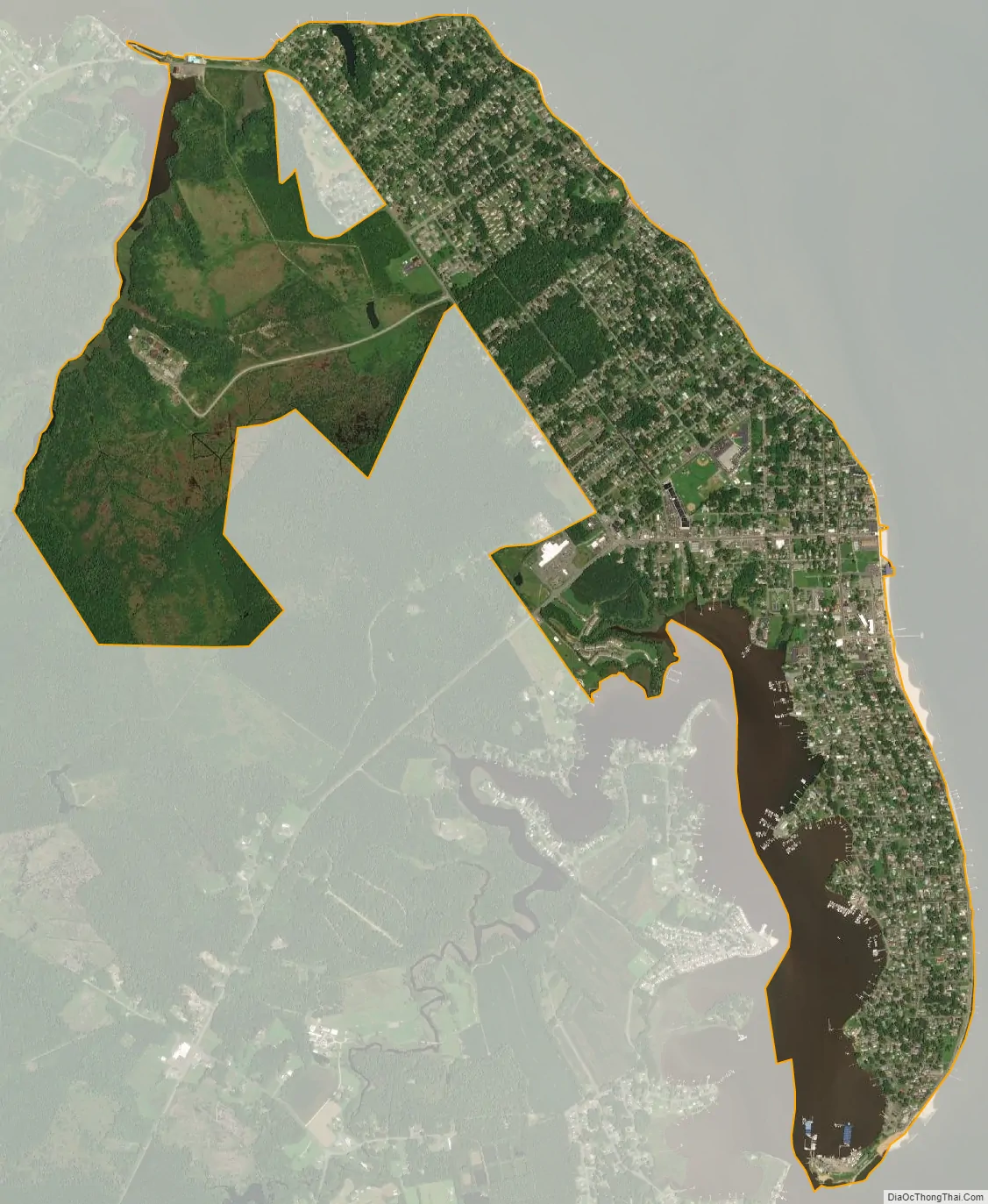
Colonial Beach city Satellite Map
Geography
Colonial Beach is located at 38°15′14″N 76°58′8″W / 38.25389°N 76.96889°W / 38.25389; -76.96889 (38.253840, −76.968941), in the northwestern part of Westmoreland County in Virginia’s Northern Neck, 65 mi (105 km) from Washington, D.C., and 70 mi (110 km) from the state capital Richmond.
The Potomac River forms the northeast boundary of Colonial Beach. The southern part of the town forms a peninsula which ends just above Monroe Bay and divides Monroe Creek from the Potomac River. A short distance north of Colonial Beach is the community of Potomac Beach and the mouth of Rosier Creek. Inland from Colonial Beach lie the settlements of Monroe Hall, near the birthplace of President James Monroe, and Maple Grove.
According to the United States Census Bureau, the town has a total area of 2.8 square miles (7.3 km), of which, 2.6 square miles (6.7 km) of it is land and 0.2 square miles (0.52 km) of it (8.80%) is water. The town’s 2.5 miles (4.0 km) of beaches are second in length only to those of Virginia Beach in the Commonwealth of Virginia.
Climate
The climate in this area is characterized by hot, humid summers and generally mild to cool winters. According to the Köppen Climate Classification system, Colonial Beach has a humid subtropical climate, abbreviated “Cfa” on climate maps.
See also
Map of Virginia State and its subdivision:- Accomack
- Albemarle
- Alexandria
- Alleghany
- Amelia
- Amherst
- Appomattox
- Arlington
- Augusta
- Bath
- Bedford
- Bedford City
- Bland
- Botetourt
- Bristol
- Brunswick
- Buchanan
- Buckingham
- Buena Vista
- Campbell
- Caroline
- Carroll
- Charles City
- Charlotte
- Charlottesville
- Chesapeake
- Chesterfield
- Clarke
- Clifton Forge City
- Colonial Heights
- Covington
- Craig
- Culpeper
- Cumberland
- Danville
- Dickenson
- Dinwiddie
- Emporia
- Essex
- Fairfax
- Fairfax City
- Falls Church
- Fauquier
- Floyd
- Fluvanna
- Franklin
- Frederick
- Fredericksburg
- Galax
- Giles
- Gloucester
- Goochland
- Grayson
- Greene
- Greensville
- Halifax
- Hampton
- Hanover
- Harrisonburg
- Henrico
- Henry
- Highland
- Hopewell
- Isle of Wight
- James City
- King and Queen
- King George
- King William
- Lancaster
- Lee
- Lexington
- Loudoun
- Louisa
- Lunenburg
- Lynchburg
- Madison
- Manassas
- Manassas Park
- Martinsville
- Mathews
- Mecklenburg
- Middlesex
- Montgomery
- Nelson
- New Kent
- Newport News
- Norfolk
- Northampton
- Northumberland
- Norton
- Nottoway
- Orange
- Page
- Patrick
- Petersburg
- Pittsylvania
- Poquoson
- Portsmouth
- Powhatan
- Prince Edward
- Prince George
- Prince William
- Pulaski
- Radford
- Rappahannock
- Richmond
- Roanoke
- Roanoke City
- Rockbridge
- Rockingham
- Russell
- Salem
- Scott
- Shenandoah
- Smyth
- Southampton
- Spotsylvania
- Stafford
- Staunton
- Suffolk
- Surry
- Sussex
- Tazewell
- Virginia Beach
- Warren
- Washington
- Waynesboro
- Westmoreland
- Williamsburg
- Winchester
- Wise
- Wythe
- York
- Alabama
- Alaska
- Arizona
- Arkansas
- California
- Colorado
- Connecticut
- Delaware
- District of Columbia
- Florida
- Georgia
- Hawaii
- Idaho
- Illinois
- Indiana
- Iowa
- Kansas
- Kentucky
- Louisiana
- Maine
- Maryland
- Massachusetts
- Michigan
- Minnesota
- Mississippi
- Missouri
- Montana
- Nebraska
- Nevada
- New Hampshire
- New Jersey
- New Mexico
- New York
- North Carolina
- North Dakota
- Ohio
- Oklahoma
- Oregon
- Pennsylvania
- Rhode Island
- South Carolina
- South Dakota
- Tennessee
- Texas
- Utah
- Vermont
- Virginia
- Washington
- West Virginia
- Wisconsin
- Wyoming