Port Royal is an incorporated town in Caroline County, Virginia, United States. The population was 126 at the 2010 census.
Port Royal was established in the mid-17th century in the Colony of Virginia primarily as a port at the head of the navigable reach of the Rappahannock River for export of tobacco, Virginia’s cash crop. The town developed along an early stage road, which brought passengers and freight for embarkation on ships at the river. It is near the crossroads of the busy modern highways of U.S. Route 17 and U.S. Route 301.
| Name: | Port Royal town |
|---|---|
| LSAD Code: | 43 |
| LSAD Description: | town (suffix) |
| State: | Virginia |
| County: | Caroline County |
| Elevation: | 30 ft (9 m) |
| Total Area: | 0.65 sq mi (1.69 km²) |
| Land Area: | 0.65 sq mi (1.68 km²) |
| Water Area: | 0.00 sq mi (0.01 km²) |
| Total Population: | 126 |
| Population Density: | 317.90/sq mi (122.72/km²) |
| ZIP code: | 22535 |
| Area code: | 804 |
| FIPS code: | 5163928 |
| GNISfeature ID: | 1499899 |
| Website: | www.co.caroline.va.us |
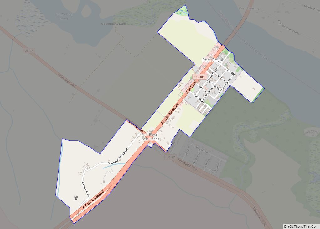
Online Interactive Map
Click on ![]() to view map in "full screen" mode.
to view map in "full screen" mode.
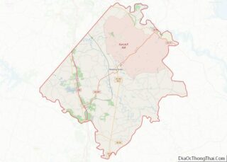
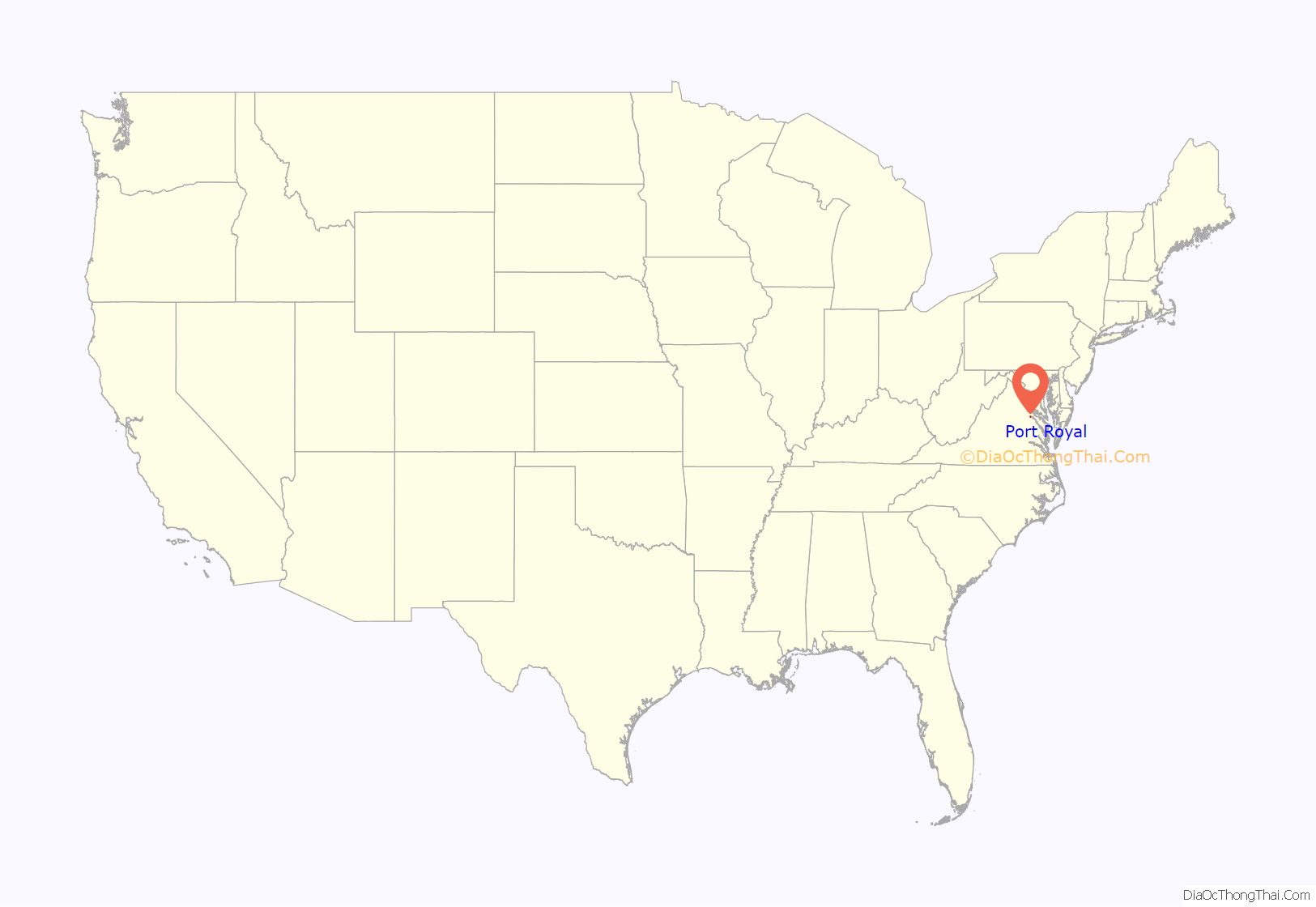
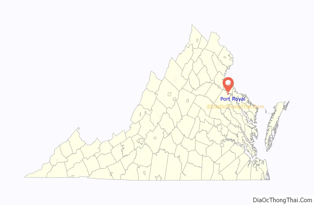
Port Royal location map. Where is Port Royal town?
History
17th century origins
Port Royal is one of the area’s oldest colonial settlements. It was first established in 1652 by English colonists as a port at the head of sea-going navigation on the Rappahannock River. Waterways were the fastest and easiest method of transportation of people and property in the British colony of Virginia. It was an important point for export of tobacco, Virginia’s cash crop.
Local tradition holds that Port Royal was named after the Roy family. Dorothy Roy and her husband John owned a warehouse chartered by the crown, a ferry service across the Rappahannock River to King George County, and a tavern. In the 21st century, the chimneys of the Roy house are preserved landmarks in the town.
Port Royal was incorporated as a town in 1744. The “town green”, where the Town Hall and the firehouse stand today, was forever reserved “for public and civic use”.
19th-20th centuries
Shipping of property from the port began to decline after completion of competing railroads in Virginia, beginning in the 1830s. But the last scheduled passenger ship service ended in 1932, supplanted by highways. However, Port Royal was served by the new highways which became U.S. Route 17 and U.S. Route 301, with their crossroads at Port Royal.
Port Royal’s most notable claim to fame is that John Wilkes Booth was killed about two miles outside town by Sgt. Boston Corbett, part of a contingent of federal troops, at the now obsolete Garrett farmstead on April 26, 1865. Booth had assassinated United States President Abraham Lincoln on the night of April 14, 1865 at Ford’s Theatre in Washington, DC.
Booth initially escaped through southern Maryland, fleeing to Virginia across the Potomac and Rappahannock rivers. He was cornered in a tobacco barn on the Garrett farm at sunrise. Shot through the neck and instantly paralyzed, Booth died on the porch of the Garrett house, where he was carried from the barn. David Herold, one of his accomplices, was with him and captured at the Garrett farm. He was tried, convicted, and hanged on July 7, 1865 in Washington, DC, along with other conspirators.
Poet Judith Lomax lived in Port Royal for some years.
Port Royal Road Map
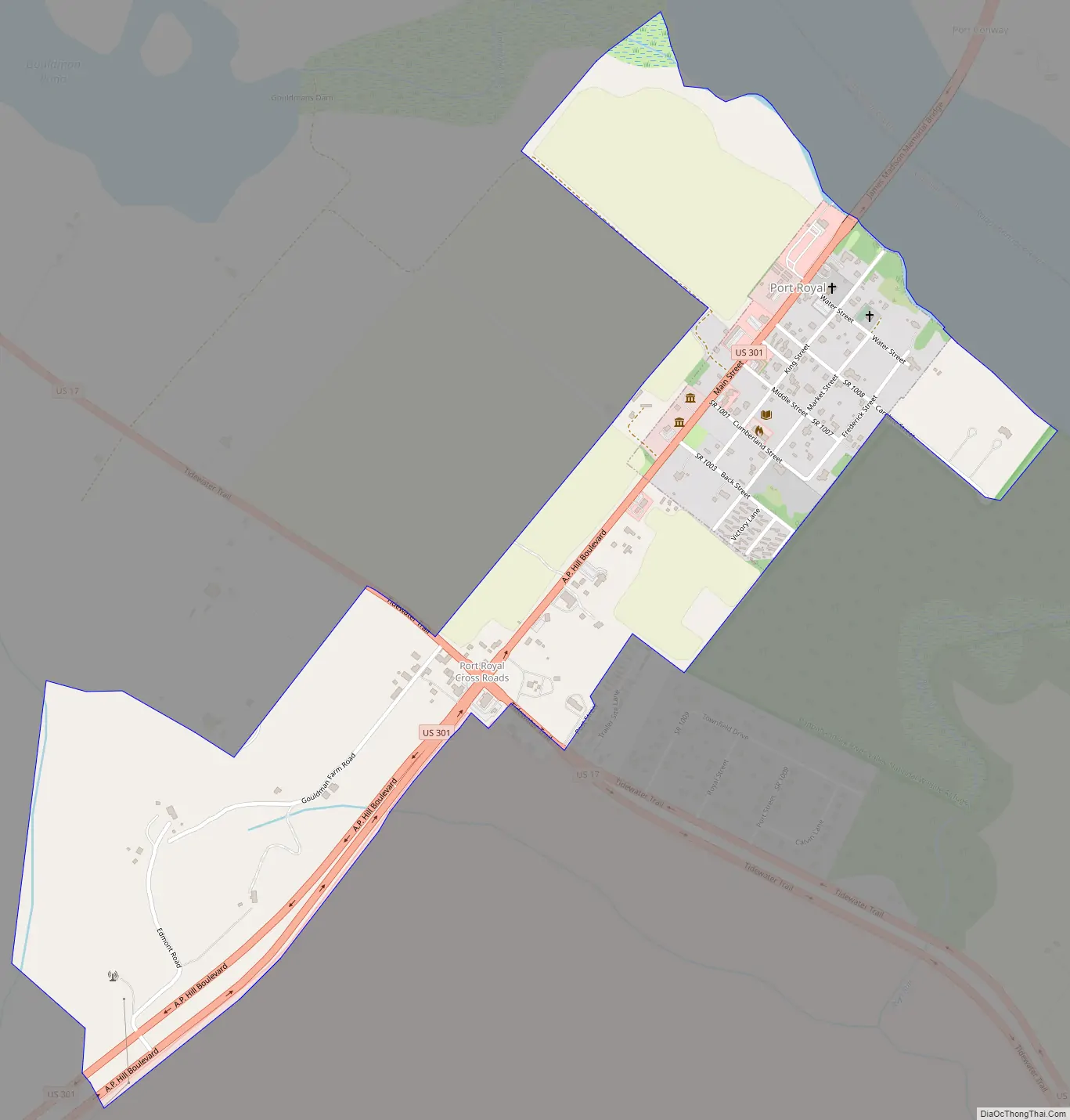
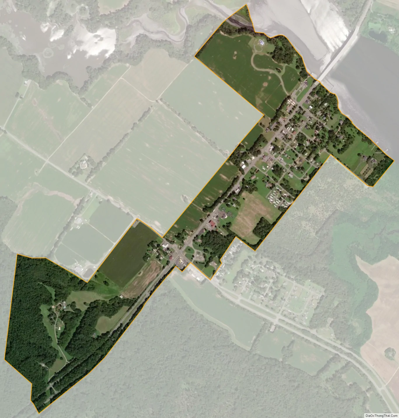
Port Royal city Satellite Map
Geography
Port Royal is located in northern Caroline County at 38°10′11″N 77°11′27″W / 38.16972°N 77.19083°W / 38.16972; -77.19083 (38.169799, −77.190763), on the south bank of the Rappahannock River.
U.S. Routes 17 and 301 intersect just southwest of the town limits. US 17 leads northwest 21 miles (34 km) to Fredericksburg and southeast 27 miles (43 km) to Tappahannock, while US 301 leads northeast 17 miles (27 km) to the Governor Harry W. Nice Memorial Bridge over the Potomac River and southwest 12 miles (19 km) to Bowling Green, the Caroline County seat.
According to the United States Census Bureau, the tiny town’s total area in 2010 was 0.10 square miles (0.27 km), all land. In July 2014, the county approved new boundaries, and the town quintupled in size to 481 acres (.75 square miles).
See also
Map of Virginia State and its subdivision:- Accomack
- Albemarle
- Alexandria
- Alleghany
- Amelia
- Amherst
- Appomattox
- Arlington
- Augusta
- Bath
- Bedford
- Bedford City
- Bland
- Botetourt
- Bristol
- Brunswick
- Buchanan
- Buckingham
- Buena Vista
- Campbell
- Caroline
- Carroll
- Charles City
- Charlotte
- Charlottesville
- Chesapeake
- Chesterfield
- Clarke
- Clifton Forge City
- Colonial Heights
- Covington
- Craig
- Culpeper
- Cumberland
- Danville
- Dickenson
- Dinwiddie
- Emporia
- Essex
- Fairfax
- Fairfax City
- Falls Church
- Fauquier
- Floyd
- Fluvanna
- Franklin
- Frederick
- Fredericksburg
- Galax
- Giles
- Gloucester
- Goochland
- Grayson
- Greene
- Greensville
- Halifax
- Hampton
- Hanover
- Harrisonburg
- Henrico
- Henry
- Highland
- Hopewell
- Isle of Wight
- James City
- King and Queen
- King George
- King William
- Lancaster
- Lee
- Lexington
- Loudoun
- Louisa
- Lunenburg
- Lynchburg
- Madison
- Manassas
- Manassas Park
- Martinsville
- Mathews
- Mecklenburg
- Middlesex
- Montgomery
- Nelson
- New Kent
- Newport News
- Norfolk
- Northampton
- Northumberland
- Norton
- Nottoway
- Orange
- Page
- Patrick
- Petersburg
- Pittsylvania
- Poquoson
- Portsmouth
- Powhatan
- Prince Edward
- Prince George
- Prince William
- Pulaski
- Radford
- Rappahannock
- Richmond
- Roanoke
- Roanoke City
- Rockbridge
- Rockingham
- Russell
- Salem
- Scott
- Shenandoah
- Smyth
- Southampton
- Spotsylvania
- Stafford
- Staunton
- Suffolk
- Surry
- Sussex
- Tazewell
- Virginia Beach
- Warren
- Washington
- Waynesboro
- Westmoreland
- Williamsburg
- Winchester
- Wise
- Wythe
- York
- Alabama
- Alaska
- Arizona
- Arkansas
- California
- Colorado
- Connecticut
- Delaware
- District of Columbia
- Florida
- Georgia
- Hawaii
- Idaho
- Illinois
- Indiana
- Iowa
- Kansas
- Kentucky
- Louisiana
- Maine
- Maryland
- Massachusetts
- Michigan
- Minnesota
- Mississippi
- Missouri
- Montana
- Nebraska
- Nevada
- New Hampshire
- New Jersey
- New Mexico
- New York
- North Carolina
- North Dakota
- Ohio
- Oklahoma
- Oregon
- Pennsylvania
- Rhode Island
- South Carolina
- South Dakota
- Tennessee
- Texas
- Utah
- Vermont
- Virginia
- Washington
- West Virginia
- Wisconsin
- Wyoming