St. Marys is a city in Camden County, Georgia, United States, located on the southern border of Camden County on the St. Marys River in the state’s Low Country. The Florida border is just to the south across the river, Cumberland Island National Seashore is to the northeast, and Kingsland, Georgia, is to the west. Jacksonville, Florida, is 38 miles south, and Savannah, Georgia, is 110 miles north.
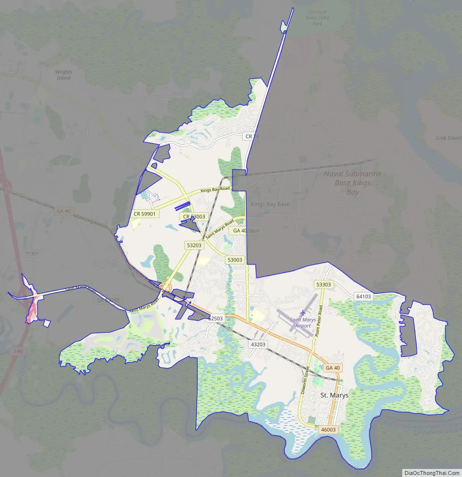
The city is home to the National Seashore’s visitor center and boat access; the St. Marys Submarine Museum, and Crooked River State Park. It is bordered by Kings Bay Naval Submarine Base, home port for several Ohio-class submarines. The city hosts the annual St. Marys Rock Shrimp Festival.
The area was first explored in the mid-16th century by Spanish expeditions as part of the settlement of Spanish Florida. Through the decades it also came under the colonial influence of Great Britain and finally the United States. By the 2020 census, the city had a population of 18,256.
| Name: | St. Marys city |
|---|---|
| LSAD Code: | 25 |
| LSAD Description: | city (suffix) |
| State: | Georgia |
| County: | Camden County |
| Elevation: | 10 ft (3 m) |
| Total Area: | 25.00 sq mi (64.74 km²) |
| Land Area: | 22.82 sq mi (59.11 km²) |
| Water Area: | 2.18 sq mi (5.63 km²) |
| Total Population: | 18,256 |
| Population Density: | 799.93/sq mi (308.85/km²) |
| ZIP code: | 31558 |
| Area code: | Area code 912 |
| FIPS code: | 1367984 |
| GNISfeature ID: | 0356510 |
| Website: | www.stmarysga.gov |
Online Interactive Map
Click on ![]() to view map in "full screen" mode.
to view map in "full screen" mode.
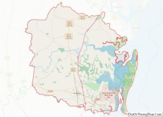
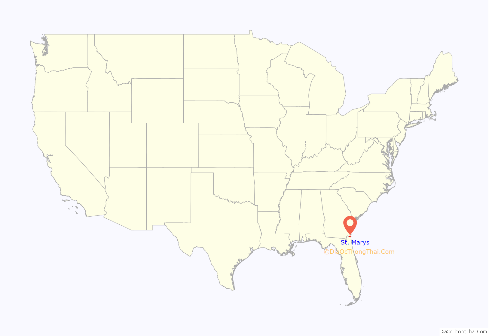
St. Marys location map. Where is St. Marys city?
History
The St. Marys river area was first explored by Spanish expeditions in the mid 16th century as part of the settlement of Spanish Florida, with nearby St. Augustine as the established capital. The original Spanish settlement was founded in 1566, making this the second-oldest continuously inhabited European-established settlement in the what became contiguous United States. Settlement for colonial Georgians became legal after the Treaty of Paris in 1763, when Britain exchanged some territory with Spain after defeating France in the Seven Years War.
Following independence in the American Revolutionary War, local inhabitants of Camden County gathered on Cumberland Island and signed a charter for “a town on the St. Marys” on November 20, 1787. There were twenty charter members, who each received four town lots and one marsh lot (outside the boundary of the town on the east side in the marshes); each lot was 4 acres (1.6 ha) square, with the total town area being 2,041 acres (826 ha). These twenty city founders are named on an historical marker in downtown St. Marys: Isaac Wheeler, William Norris, Nathaniel Ashley, William Ashley, Lodowick Ashley, James Seagrove, James Finley, John Fleming, Robert Seagrove, Henry Osborne, Thomas Norris, Jacob Weed, John Alexander, Langley Bryant, Jonathan Bartlett, Stephen Conyers, William Keady, Prentis Gallup, Simeon Dillingham and Richard Cole.
The original boundaries of the town correspond to the modern waterfront, Bartlett Street, North Street, and a block east of Norris Street. There were two public town squares. However, in the original deed the town was unnamed, and for several years afterwards in public documents it was referred to as either St. Marys or St. Patrick’s, and colloquially as simply “the New Town”. Accounts differ regarding the origin of the name—some say it is named after the St. Marys River, while others say it comes from a seventeenth-century Spanish mission, Santa Maria, on nearby Amelia Island, Florida. St. Marys was recognized by an act of the Georgia legislature on December 5, 1792, with the result of incorporation in November 1802.
Oak Grove Cemetery is included in the St. Marys Historic District and was laid outside the western border of St. Marys during its founding in 1787.
On June 29, 1796, the Treaty of Colerain was signed just up the river from St Marys between the United States and the Creek Nation, the indigenous inhabitants of this territory. St. Marys town founder Langley Bryant served as the official interpreter between the Creek Indians and the United States.
St. Marys was made a United States port of entry by act of the U.S. Congress March 2, 1799. The first Collector was James Seagrove. During the antebellum period, Archibald Clark served as the U.S. Customs Collector from 1807 until his death in 1848.
After the Act Prohibiting Importation of Slaves took effect in 1808, St. Marys became, along with Spanish Amelia Island, a center for smuggling, especially during the period between 1812-1819 when various rebel groups held Amelia Island.
During the War of 1812 the Battle of Fort Peter occurred near the town, at the fort on Point Peter along the St. Marys River. The British captured the fort and the town and occupied it for about a month.
The United States Navy bombarded the town’s shoreside buildings during the American Civil War.
St. Marys served as Camden County’s seat of government from 1869 until 1923.
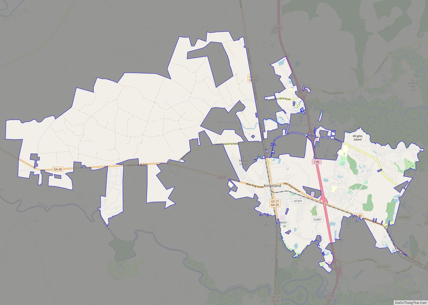
St. Marys Road Map
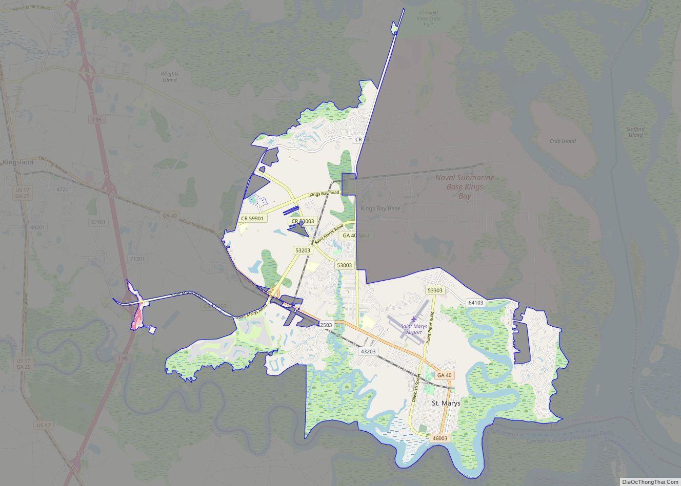
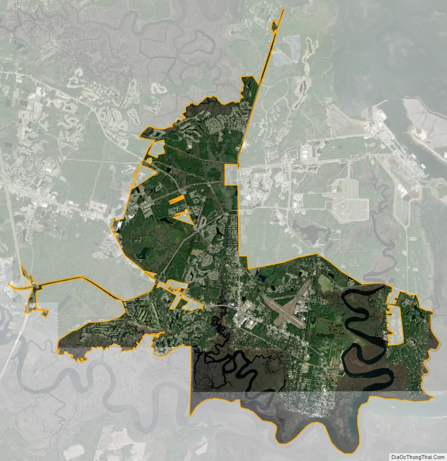
St. Marys city Satellite Map
Geography
St. Marys is located along the southern border of Camden County on the north bank of the St. Marys River. The state of Florida is to the south, across the river. The city of Kingsland borders St. Marys to the west.
According to the United States Census Bureau, St. Marys has a total area of 24.9 square miles (64.5 km), of which 22.5 square miles (58.3 km) is land and 2.4 square miles (6.2 km), or 9.57%, is water.
Climate
St. Marys has a humid subtropical climate (Cfa) with long, hot summers and short, mild winters.
See also
Map of Georgia State and its subdivision:- Appling
- Atkinson
- Bacon
- Baker
- Baldwin
- Banks
- Barrow
- Bartow
- Ben Hill
- Berrien
- Bibb
- Bleckley
- Brantley
- Brooks
- Bryan
- Bulloch
- Burke
- Butts
- Calhoun
- Camden
- Candler
- Carroll
- Catoosa
- Charlton
- Chatham
- Chattahoochee
- Chattooga
- Cherokee
- Clarke
- Clay
- Clayton
- Clinch
- Cobb
- Coffee
- Colquitt
- Columbia
- Cook
- Coweta
- Crawford
- Crisp
- Dade
- Dawson
- Decatur
- DeKalb
- Dodge
- Dooly
- Dougherty
- Douglas
- Early
- Echols
- Effingham
- Elbert
- Emanuel
- Evans
- Fannin
- Fayette
- Floyd
- Forsyth
- Franklin
- Fulton
- Gilmer
- Glascock
- Glynn
- Gordon
- Grady
- Greene
- Gwinnett
- Habersham
- Hall
- Hancock
- Haralson
- Harris
- Hart
- Heard
- Henry
- Houston
- Irwin
- Jackson
- Jasper
- Jeff Davis
- Jefferson
- Jenkins
- Johnson
- Jones
- Lamar
- Lanier
- Laurens
- Lee
- Liberty
- Lincoln
- Long
- Lowndes
- Lumpkin
- Macon
- Madison
- Marion
- McDuffie
- McIntosh
- Meriwether
- Miller
- Mitchell
- Monroe
- Montgomery
- Morgan
- Murray
- Muscogee
- Newton
- Oconee
- Oglethorpe
- Paulding
- Peach
- Pickens
- Pierce
- Pike
- Polk
- Pulaski
- Putnam
- Quitman
- Rabun
- Randolph
- Richmond
- Rockdale
- Schley
- Screven
- Seminole
- Spalding
- Stephens
- Stewart
- Sumter
- Talbot
- Taliaferro
- Tattnall
- Taylor
- Telfair
- Terrell
- Thomas
- Tift
- Toombs
- Towns
- Treutlen
- Troup
- Turner
- Twiggs
- Union
- Upson
- Walker
- Walton
- Ware
- Warren
- Washington
- Wayne
- Webster
- Wheeler
- White
- Whitfield
- Wilcox
- Wilkes
- Wilkinson
- Worth
- Alabama
- Alaska
- Arizona
- Arkansas
- California
- Colorado
- Connecticut
- Delaware
- District of Columbia
- Florida
- Georgia
- Hawaii
- Idaho
- Illinois
- Indiana
- Iowa
- Kansas
- Kentucky
- Louisiana
- Maine
- Maryland
- Massachusetts
- Michigan
- Minnesota
- Mississippi
- Missouri
- Montana
- Nebraska
- Nevada
- New Hampshire
- New Jersey
- New Mexico
- New York
- North Carolina
- North Dakota
- Ohio
- Oklahoma
- Oregon
- Pennsylvania
- Rhode Island
- South Carolina
- South Dakota
- Tennessee
- Texas
- Utah
- Vermont
- Virginia
- Washington
- West Virginia
- Wisconsin
- Wyoming