Brookhaven is a city in the northeastern suburbs of Atlanta that is located in western DeKalb County, Georgia, United States, directly northeast of Atlanta. On July 31, 2012, Brookhaven was approved in a referendum to become DeKalb County’s 11th city. Incorporation officially took place on December 17, 2012, on which date municipal operations commenced. With a population of around 55,366 as of 2021, it is the largest city in DeKalb County. The new city stretches over 12 square miles (31 km).
| Name: | Brookhaven city |
|---|---|
| LSAD Code: | 25 |
| LSAD Description: | city (suffix) |
| State: | Georgia |
| County: | DeKalb County |
| Total Area: | 11.86 sq mi (30.71 km²) |
| Land Area: | 11.73 sq mi (30.39 km²) |
| Water Area: | 0.12 sq mi (0.31 km²) |
| Total Population: | 55,161 |
| Population Density: | 4,700.55/sq mi (1,814.85/km²) |
| ZIP code: | 30319, 30341 |
| Area code: | 404/470/678/770 |
| FIPS code: | 1310944 |
| GNISfeature ID: | 331243 |
| Website: | brookhavenga.gov |
Online Interactive Map
Click on ![]() to view map in "full screen" mode.
to view map in "full screen" mode.
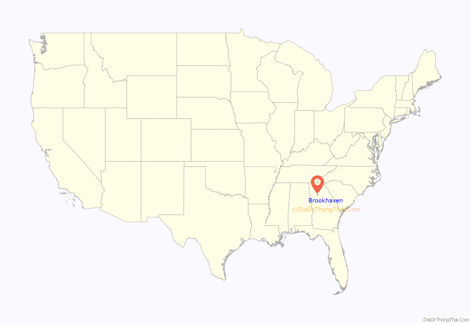
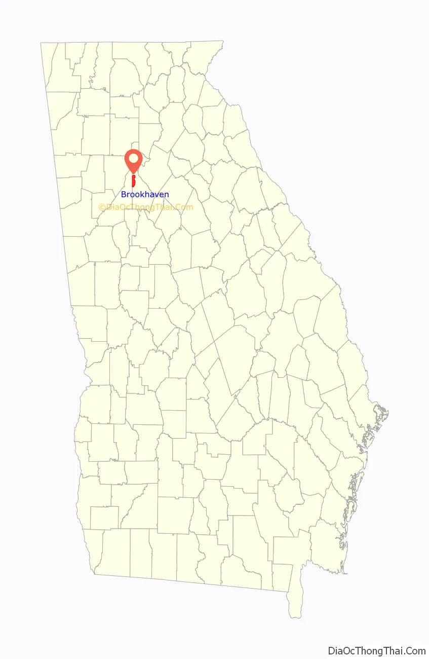
Brookhaven location map. Where is Brookhaven city?
History
Brookhaven’s first permanent European settler was John Evins, who started a plantation around 1810. Harris and Solomon Goodwin, who moved to Georgia from South Carolina, became owners of the land in the 1830s. The Goodwin home and the family graveyard have been preserved at the 3900 block of Peachtree Road, near Dresden Drive. A train station known as Goodwin’s was constructed along the Atlanta and Richmond (later Atlanta and Charlotte) railway in 1873.
The settlement of Cross Keys, with a population of 250 in 1876, was located one mile (2 km) north along the rail line from Goodwin’s. In 1879 Cross Keys was described:
Atlanta residents began constructing summer cottages in the community around 1900. In 1910, 150 acres (61 ha) on the north side of Peachtree Road were purchased for development as a planned community surrounding a golf course. The nine-hole golf course, designed by Herbert Barker, a golf pro from Garden City, Long Island, opened in 1912. Residences developed in three phases, with Brookhaven Estates designed in 1910, followed by Country Club Estates in 1929 and the Carleton Operating Company in 1936. Independently, Edwin P. Ansley sold lots in the area, calling it Oglethorpe Park. Construction of the historic neighborhood was largely complete by the end of World War II. The country club became part of the downtown Capital City Club in 1911, and its name was changed to the Capital City Country Club. The golf course was expanded from nine to eighteen holes in 1915. The clubhouse, designed by Preston Stevens in the French Provincial style, was completed in 1928.
The area was incorporated as the city of North Atlanta in 1924. In 1963, the North Atlanta’s leaders asked the state legislature to allow a referendum on a new city charter. The legislature agreed, but also included an additional option in the referendum: disincorporation. The majority of voters chose disincorporation, and the city’s charter was dissolved in 1965.
From the 1950s to the 1970s, major commercial and residential development took place in Brookhaven, resulting in the area being largely built-out by 1980. The Brookhaven/Oglethorpe MARTA Station opened in 1984. In 1986, the Capital City Club and its surrounding estate homes were placed on the National Register of Historic Places, and the neighborhood is now officially known as “Historic Brookhaven.”
The idea of incorporating Brookhaven as a city was first brought up in 2007, with the purpose of securing local community control over planning, zoning, land use, police, fire protection, and parks and recreation—rather than having those issues decided by the county. However, the idea failed to gain momentum. The proposed city would have included 53,000 people. In 2011, the incorporation of Brookhaven was revived when state Rep. Mike Jacobs announced plans to introduce legislation allowing the creation of a city of Brookhaven, over the objections of many residents of the neighborhood of Historic Brookhaven, which would not lie in the proposed city boundaries. On July 31, 2012, 55% of voters chose to incorporate the city of Brookhaven. In December of that same year, J. Max Davis was elected as the city’s first mayor.
Brookhaven Road Map
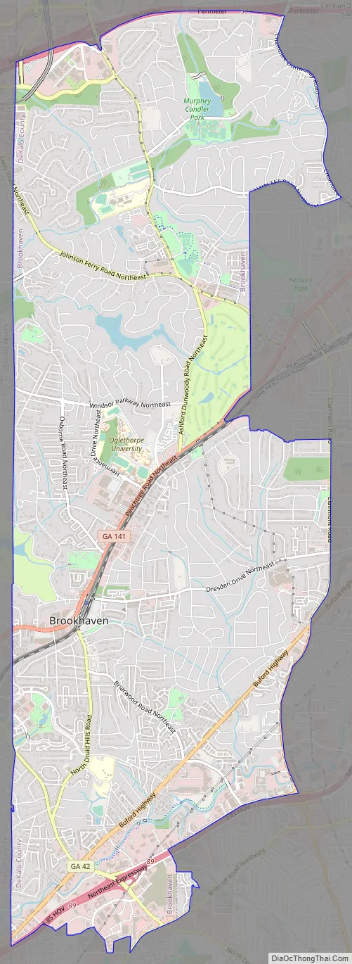
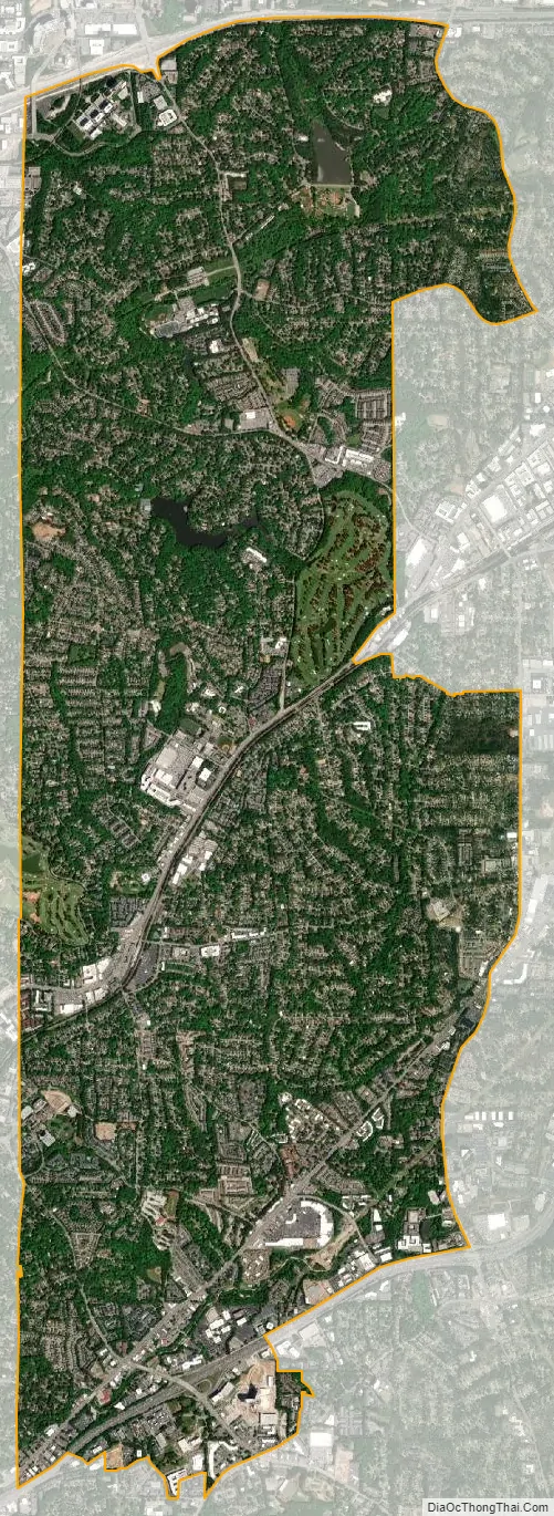
Brookhaven city Satellite Map
Geography
Brookhaven is located at 33°52′47″N 84°21′6″W / 33.87972°N 84.35167°W / 33.87972; -84.35167 (33.879722, -84.351667). The city of Brookhaven is bounded by:
- The Fulton County line on the west,
- unincorporated DeKalb County south of Briarcliff and LaVista Roads on the south,
- Clairmont Road and the city of Chamblee at Chamblee Dunwoody Road on the east, and
- the city of Dunwoody at I-285 on the north
See the official City of Brookhaven map and visit: https://gis.brookhavenga.gov/citymap/
Neighborhoods and districts
- Historic Brookhaven: Historic Brookhaven is the historic residential neighborhood from which the area derives its name. It has homes surrounding the Capital City Country Club, many designed by a number of well-known Atlanta architects of the pre-war period. The neighborhood boundaries are well defined, and it stretches from Peachtree Dunwoody Road on the west, Windsor Parkway to the north, Mabry Drive to the east, and Peachtree Road to the south. A majority of the neighborhood technically lies within the extreme northeastern section of the city of Atlanta.
- Brookhaven Village: Brookhaven Village is the name given to the urban town center that has emerged on Dresden Drive, just east of the Brookhaven MARTA station, anchored by the Village Place and Village Park Place mixed-use developments, envisioned and developed by Dan Woodley. The village is bordered by the residential neighborhoods of Ashford Park to the north and with Brookhaven Fields and Drew Valley to the south, both offering single family homes within walking distance of the village. The village is home to commercial establishments, residences, and offices.
- Lynwood Park: Lynwood Park was historically an African-American neighborhood of wood and cinderblock homes in the small area north of Windsor Parkway and east of Sandy Springs. In the last decade, residents seeking a new home in a close-in location have built crafstman-style homes, contributing to the overall improvement of the area’s infrastructure. The community is home to a large park, Lynwood Park, which features basketball courts, tennis courts, a swimming pool, a recreation center, a playground and picnic area.
- Peachtree Road: Peachtree Road connects Brookhaven to Buckhead and Chamblee. Much of Brookhaven’s commercial developments are situated along Peachtree, including Town Brookhaven, a 600,000-square-foot (56,000 m) mixed-use district located at Peachtree Road and Town Boulevard, adjacent to Oglethorpe University. In addition to major commercial tenants, there are more than 1500 residential units and 150,000 square feet (14,000 m) of office space in Town Brookhaven.
- North Brookhaven: North Brookhaven refers to the area that is bounded by I-285 to the north, the Fulton County line to the west, Chamblee to the east, and Windsor Parkway to the south. More specifically, the term describes the area that makes up the majority of District 1 of the city of Brookhaven. From 1924 to 1965, the area was incorporated as the city of North Atlanta, which included all of North Brookhaven as well as areas south to Peachtree Road. Largely suburban in character, the area is home to various residential subdivisions; two large parks, Blackburn Park and Murphey Candler Park, and the Nancy Creek PATH trail; the historic Peachtree Golf Club, which was founded by Bobby Jones and designed by Robert Trent Jones; and top rated public and private schools, including Marist School, Our Lady of the Assumption Catholic School, St. Martin’s Episcopal School, Montgomery Elementary School, and the Kittredge Magnet School. The area also boasts two major lakes: the privately owned Silver Lake (surrounded by the Brittany, Cambridge Park, Hampton Hall, and Oglethorpe Estates neighborhoods) and the county owned Murphey Candler Lake. A restaurant and retail district, located at the intersection of Ashford Dunwoody and Johnson Ferry Roads, forms the commercial heart of North Brookhaven, occupying an area that was once known as Old Cross Keys, one of the earliest antebellum settlements in DeKalb County. Also located in North Brookhaven is Perimeter Summit, a commercial area that represents one third of Perimter Center. North Brookhaven, due to its proximity to Perimeter Center, has often been subjected to encroachment, resulting in the razing of Lake Hearn subdivision in 1989, a proposed extension of the Glenridge Connector in 1999, and the construction of a power station in 2007.
- Buford Highway: The Buford Highway corridor forms the southern portion of Brookhaven. The corridor is characterized by high-density housing with a large international population, mostly comprising Hispanic immigrants. Due to its international character and ethnic restaurants and businesses catering to a variety of groups, including Hispanic, Chinese, Vietnamese, and Korean, Buford Highway has become a testament to the Atlanta region’s growing multiethnic makeup.
- Lenox Park: Lenox Park is a neighborhood of homes and office buildings located just east of the northern border of the city of Atlanta.
- LaVista Park: The LaVista Park neighborhood was annexed into the City of Brookhaven in 2019 in a unanimous decision by the Brookhaven City Council. The Council approved a rezoning and annexation of 676 parcels (approximately 2,000 residents) into the City of Brookhaven in what is believed to be the largest annexation using the 60% method in state history.
See also
Map of Georgia State and its subdivision:- Appling
- Atkinson
- Bacon
- Baker
- Baldwin
- Banks
- Barrow
- Bartow
- Ben Hill
- Berrien
- Bibb
- Bleckley
- Brantley
- Brooks
- Bryan
- Bulloch
- Burke
- Butts
- Calhoun
- Camden
- Candler
- Carroll
- Catoosa
- Charlton
- Chatham
- Chattahoochee
- Chattooga
- Cherokee
- Clarke
- Clay
- Clayton
- Clinch
- Cobb
- Coffee
- Colquitt
- Columbia
- Cook
- Coweta
- Crawford
- Crisp
- Dade
- Dawson
- Decatur
- DeKalb
- Dodge
- Dooly
- Dougherty
- Douglas
- Early
- Echols
- Effingham
- Elbert
- Emanuel
- Evans
- Fannin
- Fayette
- Floyd
- Forsyth
- Franklin
- Fulton
- Gilmer
- Glascock
- Glynn
- Gordon
- Grady
- Greene
- Gwinnett
- Habersham
- Hall
- Hancock
- Haralson
- Harris
- Hart
- Heard
- Henry
- Houston
- Irwin
- Jackson
- Jasper
- Jeff Davis
- Jefferson
- Jenkins
- Johnson
- Jones
- Lamar
- Lanier
- Laurens
- Lee
- Liberty
- Lincoln
- Long
- Lowndes
- Lumpkin
- Macon
- Madison
- Marion
- McDuffie
- McIntosh
- Meriwether
- Miller
- Mitchell
- Monroe
- Montgomery
- Morgan
- Murray
- Muscogee
- Newton
- Oconee
- Oglethorpe
- Paulding
- Peach
- Pickens
- Pierce
- Pike
- Polk
- Pulaski
- Putnam
- Quitman
- Rabun
- Randolph
- Richmond
- Rockdale
- Schley
- Screven
- Seminole
- Spalding
- Stephens
- Stewart
- Sumter
- Talbot
- Taliaferro
- Tattnall
- Taylor
- Telfair
- Terrell
- Thomas
- Tift
- Toombs
- Towns
- Treutlen
- Troup
- Turner
- Twiggs
- Union
- Upson
- Walker
- Walton
- Ware
- Warren
- Washington
- Wayne
- Webster
- Wheeler
- White
- Whitfield
- Wilcox
- Wilkes
- Wilkinson
- Worth
- Alabama
- Alaska
- Arizona
- Arkansas
- California
- Colorado
- Connecticut
- Delaware
- District of Columbia
- Florida
- Georgia
- Hawaii
- Idaho
- Illinois
- Indiana
- Iowa
- Kansas
- Kentucky
- Louisiana
- Maine
- Maryland
- Massachusetts
- Michigan
- Minnesota
- Mississippi
- Missouri
- Montana
- Nebraska
- Nevada
- New Hampshire
- New Jersey
- New Mexico
- New York
- North Carolina
- North Dakota
- Ohio
- Oklahoma
- Oregon
- Pennsylvania
- Rhode Island
- South Carolina
- South Dakota
- Tennessee
- Texas
- Utah
- Vermont
- Virginia
- Washington
- West Virginia
- Wisconsin
- Wyoming