Chamblee (/ˈʃæmbliː/ SHAM-blee) is a city in northern DeKalb County, Georgia, United States, northeast of Atlanta. The population was 30,164 as of the 2020 census.
| Name: | Chamblee city |
|---|---|
| LSAD Code: | 25 |
| LSAD Description: | city (suffix) |
| State: | Georgia |
| County: | DeKalb County |
| Elevation: | 1,020 ft (311 m) |
| Total Area: | 7.70 sq mi (19.94 km²) |
| Land Area: | 7.69 sq mi (19.93 km²) |
| Water Area: | 0.01 sq mi (0.02 km²) |
| Total Population: | 32,251 |
| Population Density: | 3,920.97/sq mi (1,513.87/km²) |
| ZIP code: | 30341, 30366 |
| Area code: | 770 |
| FIPS code: | 1315172 |
| GNISfeature ID: | 0331371 |
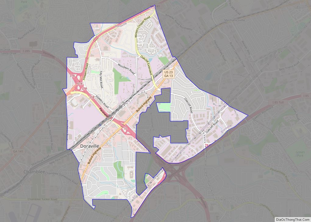
Online Interactive Map
Click on ![]() to view map in "full screen" mode.
to view map in "full screen" mode.
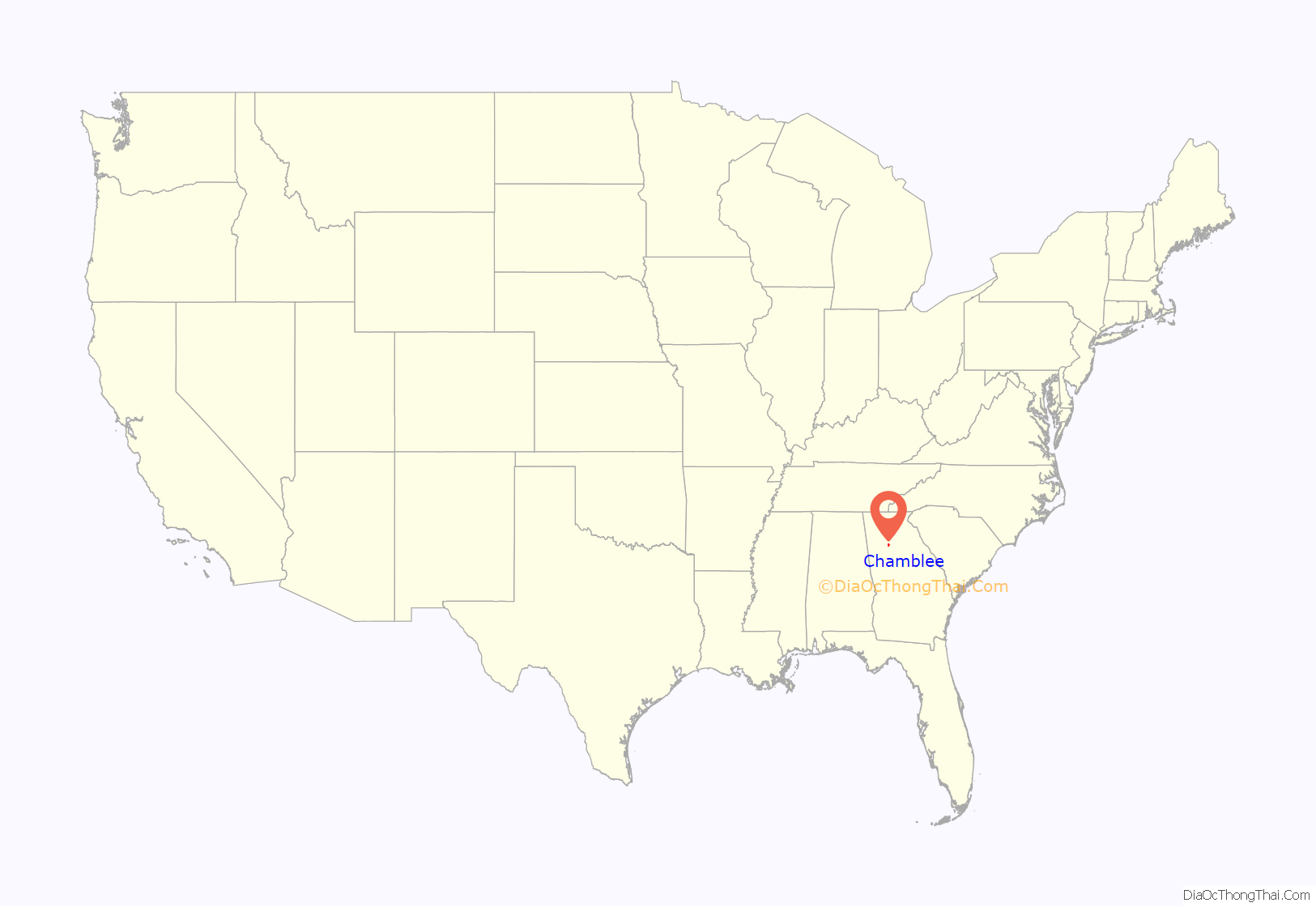
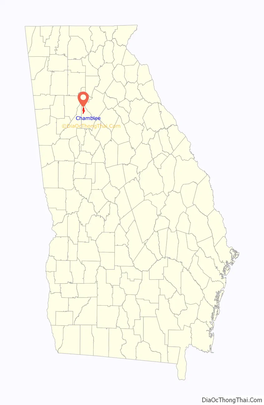
Chamblee location map. Where is Chamblee city?
History
The area that would later become Chamblee was originally dairy farms. During the late nineteenth century, an intersection of two railroads was constructed in Chamblee; one carried passengers from Atlanta to Charlotte, North Carolina, while the other ferried workers and goods back and forth from a factory in Roswell to Atlanta. A settlement known as Roswell Junction emerged at the intersection, and the United States Postal Service decided to establish a post office there. However, feeling the name of the settlement was too similar to nearby Roswell, they randomly selected Chamblee from a list of petitioners for the new post office name. Chamblee was incorporated in 1907.
During World War I and World War II, Chamblee served as the site of U.S. military operations. During World War I, the U.S. operated Camp Gordon, home to 40,000 servicemen. This influx of new people created a building boom in the town. Camp Gordon was closed after the war and then re-opened as Navy Flight Training Center at the advent of World War II.
Immediately after World War II, Chamblee experienced growth in blue-collar industry and residents due to its proximity to the newly opened General Motors plant in neighboring Doraville. Manufacturing plants also located along the newly constructed Peachtree Industrial Boulevard. By the 1980s, much of the city’s industrial base had downsized or eroded; in its place sprang up multi-ethnic businesses that catered to the immigrants and refugees moving to Chamblee and Doraville en masse due to the cities’ affordable housing. By the time of the 1996 Summer Olympics, Chamblee had emerged as a multi-cultural city inhabited by a large immigrant community.
During the first decade of the 2000s, the city grew as it refined its image, constructing a new city hall in 2002. In 2010, Chamblee annexed an area directly to the northwest that includes Huntley Hills and a resident population of approximately 5,000. It also renamed Peachtree Industrial Boulevard to Peachtree Boulevard, and took steps to revitalize its downtown. In 2012 the city had an annexation proposal that was voted down by a small margin. In November 2013 the city had another annexation proposal that was passed by voters. Following the annexation, the city and neighboring Brookhaven had a dispute in 2014 over which city would annex the Century Center development. The courts gave Century Center to Chamblee.
According to 2020 Census data, Chamblee effectively tripled its population since 2010. It started the decade with roughly 9,800 residents and ended it with more than 30,000, mostly due to two annexations. The only city to gain more residents in that time was Atlanta, and only two Georgia cities — Morgan and Pendergrass — grew at faster rates in the 2010s.City leaders have credited Chamblee’s location as a transportation hub, with close proximity to two interstates, a MARTA station and the Peachtree-DeKalb Airport, as a key reason for the city’s growth. In the early 2020s Chamblee attracted multiple mixed-use developments and office projects.
Chamblee Road Map

Chamblee city Satellite Map

Geography
Chamblee is south of Dunwoody, southwest of Doraville, northeast of Brookhaven, and north of Interstate 85. The city is located at 33°53′15″N 84°18′19″W / 33.88750°N 84.30528°W / 33.88750; -84.30528 (33.887552, -84.305326). According to the United States Census Bureau, the city has a total area of 3.1 square miles (8.0 km), all land.
See also
Map of Georgia State and its subdivision:- Appling
- Atkinson
- Bacon
- Baker
- Baldwin
- Banks
- Barrow
- Bartow
- Ben Hill
- Berrien
- Bibb
- Bleckley
- Brantley
- Brooks
- Bryan
- Bulloch
- Burke
- Butts
- Calhoun
- Camden
- Candler
- Carroll
- Catoosa
- Charlton
- Chatham
- Chattahoochee
- Chattooga
- Cherokee
- Clarke
- Clay
- Clayton
- Clinch
- Cobb
- Coffee
- Colquitt
- Columbia
- Cook
- Coweta
- Crawford
- Crisp
- Dade
- Dawson
- Decatur
- DeKalb
- Dodge
- Dooly
- Dougherty
- Douglas
- Early
- Echols
- Effingham
- Elbert
- Emanuel
- Evans
- Fannin
- Fayette
- Floyd
- Forsyth
- Franklin
- Fulton
- Gilmer
- Glascock
- Glynn
- Gordon
- Grady
- Greene
- Gwinnett
- Habersham
- Hall
- Hancock
- Haralson
- Harris
- Hart
- Heard
- Henry
- Houston
- Irwin
- Jackson
- Jasper
- Jeff Davis
- Jefferson
- Jenkins
- Johnson
- Jones
- Lamar
- Lanier
- Laurens
- Lee
- Liberty
- Lincoln
- Long
- Lowndes
- Lumpkin
- Macon
- Madison
- Marion
- McDuffie
- McIntosh
- Meriwether
- Miller
- Mitchell
- Monroe
- Montgomery
- Morgan
- Murray
- Muscogee
- Newton
- Oconee
- Oglethorpe
- Paulding
- Peach
- Pickens
- Pierce
- Pike
- Polk
- Pulaski
- Putnam
- Quitman
- Rabun
- Randolph
- Richmond
- Rockdale
- Schley
- Screven
- Seminole
- Spalding
- Stephens
- Stewart
- Sumter
- Talbot
- Taliaferro
- Tattnall
- Taylor
- Telfair
- Terrell
- Thomas
- Tift
- Toombs
- Towns
- Treutlen
- Troup
- Turner
- Twiggs
- Union
- Upson
- Walker
- Walton
- Ware
- Warren
- Washington
- Wayne
- Webster
- Wheeler
- White
- Whitfield
- Wilcox
- Wilkes
- Wilkinson
- Worth
- Alabama
- Alaska
- Arizona
- Arkansas
- California
- Colorado
- Connecticut
- Delaware
- District of Columbia
- Florida
- Georgia
- Hawaii
- Idaho
- Illinois
- Indiana
- Iowa
- Kansas
- Kentucky
- Louisiana
- Maine
- Maryland
- Massachusetts
- Michigan
- Minnesota
- Mississippi
- Missouri
- Montana
- Nebraska
- Nevada
- New Hampshire
- New Jersey
- New Mexico
- New York
- North Carolina
- North Dakota
- Ohio
- Oklahoma
- Oregon
- Pennsylvania
- Rhode Island
- South Carolina
- South Dakota
- Tennessee
- Texas
- Utah
- Vermont
- Virginia
- Washington
- West Virginia
- Wisconsin
- Wyoming