Remerton is a city in Lowndes County, Georgia, United States. The population was 1,123 at the 2010 census. It was incorporated as a town in 1951, and chartered as a city under Georgia law in 2000.
Remerton is an enclave of Valdosta and is a popular place for Valdosta State University students to live.
| Name: | Remerton city |
|---|---|
| LSAD Code: | 25 |
| LSAD Description: | city (suffix) |
| State: | Georgia |
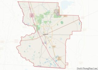
| County: | Lowndes County |
| Elevation: | 177 ft (54 m) |
| Total Area: | 0.20 sq mi (0.53 km²) |
| Land Area: | 0.20 sq mi (0.53 km²) |
| Water Area: | 0.00 sq mi (0.00 km²) |
| Total Population: | 1,334 |
| Population Density: | 6,539.22/sq mi (2,525.21/km²) |
| ZIP code: | 31601 |
| Area code: | 229 |
| FIPS code: | 1364596 |
| GNISfeature ID: | 0332830 |
| Website: | http://cityofremerton.com/ |
Online Interactive Map
Click on ![]() to view map in "full screen" mode.
to view map in "full screen" mode.
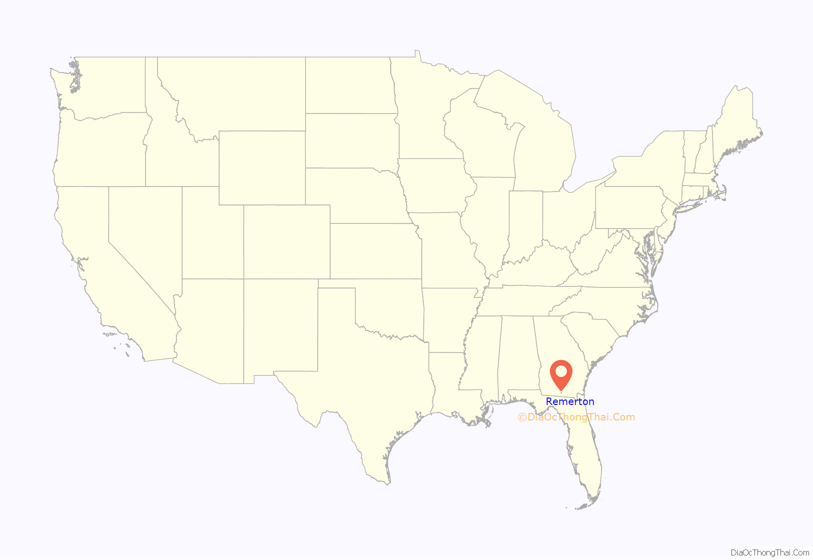
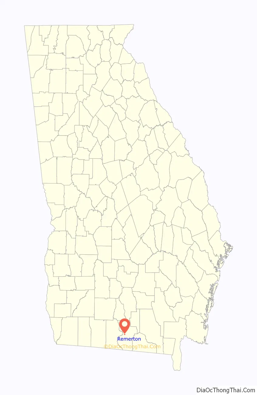
Remerton location map. Where is Remerton city?
History
Remerton was founded in 1899 as a company town for workers at the Strickland Cotton Mill. It was named for banker Remer Y. Lane. In 1951 Remerton was incorporated as municipality. In January 1979, Strickland Cotton Mills closed. Two months later the mill was purchased by Wipo Inc. and the mill began to operate as Sugar Creek Textiles.
During the 1980s Remerton underwent many changes. Apartments began being built to attract students from what was then known as Valdosta State College. Also, businesses including a Piggly Wiggly were built. In 1985 the L.E. Davis family purchased the Strickland Cotton Mill building from Sugar Creek Textiles. The next year Fred Wilkinson purchased the building and used the building for his Wilkinson Textile Company.
On 1 November 2005, the Strickland Cotton Mill building was purchased by Remerton Mills, LLC. Remerton Mills, LLC is a corporation with local businessman Joseph H. Tillman, Sr. as the registered agent. In 2006 Remerton Mills, LLC announced plans for renovating the Strickland Cotton Mill building into residential and commercial spaces.
In 2012 plans for the demolition of the historic Strickland Cotton Mill were put in motion by Remerton Mills, LLC despite calls from preservationists and locals to save it. Plans were announced to build a park at the site. The demolition of the mill building began in June 2013.
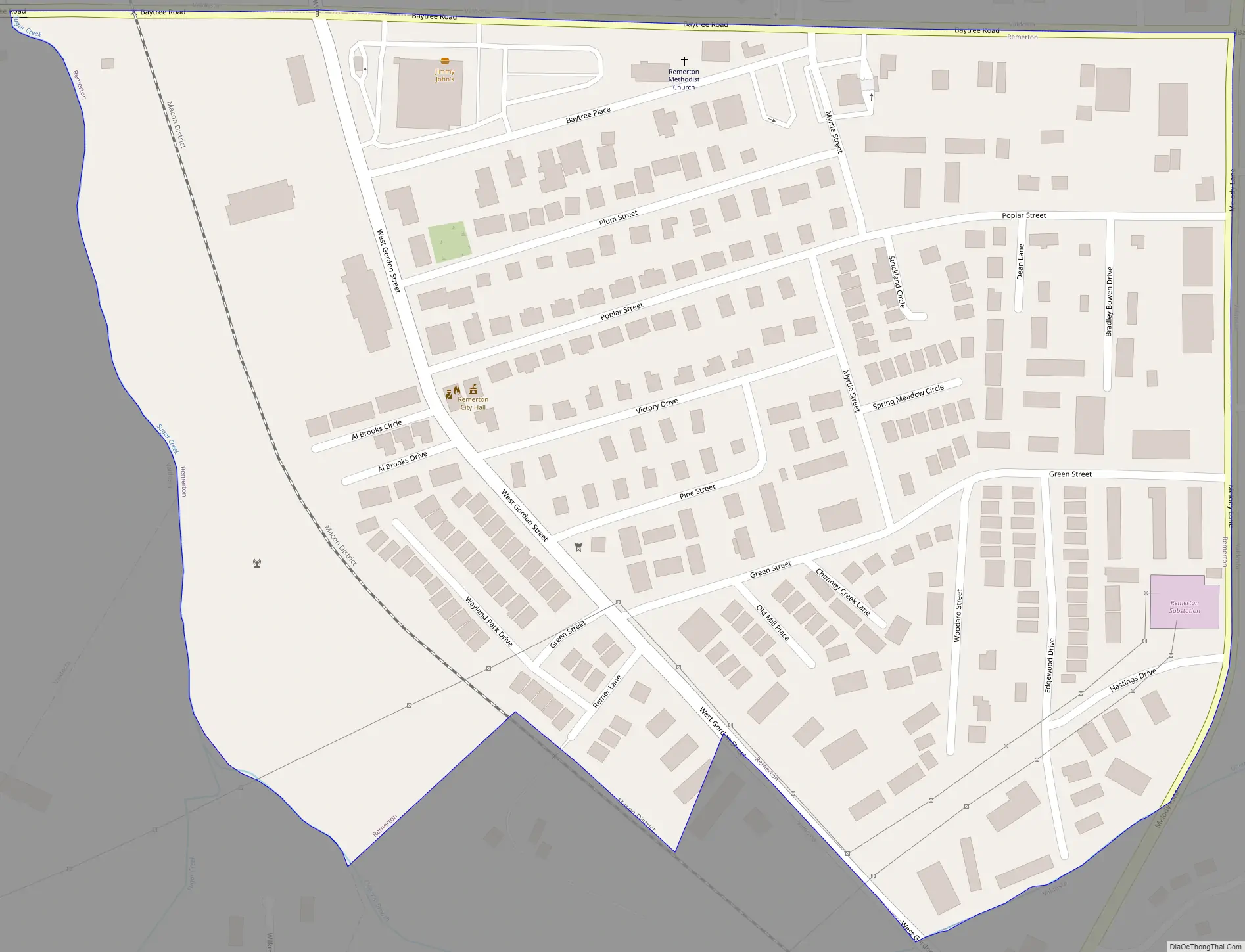
Remerton Road Map
Remerton city Satellite Map
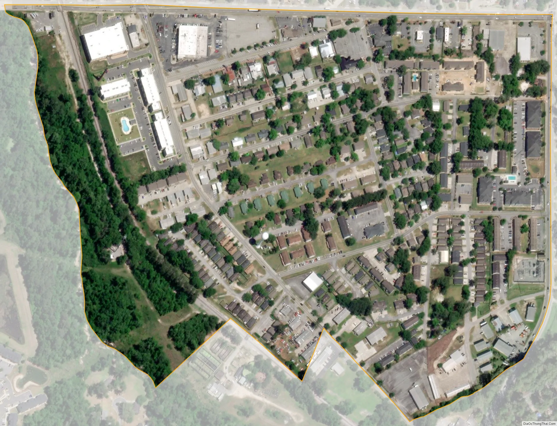
Geography
Remerton is located at 30°50′36″N 83°18′30″W / 30.84333°N 83.30833°W / 30.84333; -83.30833 (30.843572, -83.308492).
According to the United States Census Bureau, the city has a total area of 0.2 square miles (0.52 km), all land.
See also
Map of Georgia State and its subdivision:- Appling
- Atkinson
- Bacon
- Baker
- Baldwin
- Banks
- Barrow
- Bartow
- Ben Hill
- Berrien
- Bibb
- Bleckley
- Brantley
- Brooks
- Bryan
- Bulloch
- Burke
- Butts
- Calhoun
- Camden
- Candler
- Carroll
- Catoosa
- Charlton
- Chatham
- Chattahoochee
- Chattooga
- Cherokee
- Clarke
- Clay
- Clayton
- Clinch
- Cobb
- Coffee
- Colquitt
- Columbia
- Cook
- Coweta
- Crawford
- Crisp
- Dade
- Dawson
- Decatur
- DeKalb
- Dodge
- Dooly
- Dougherty
- Douglas
- Early
- Echols
- Effingham
- Elbert
- Emanuel
- Evans
- Fannin
- Fayette
- Floyd
- Forsyth
- Franklin
- Fulton
- Gilmer
- Glascock
- Glynn
- Gordon
- Grady
- Greene
- Gwinnett
- Habersham
- Hall
- Hancock
- Haralson
- Harris
- Hart
- Heard
- Henry
- Houston
- Irwin
- Jackson
- Jasper
- Jeff Davis
- Jefferson
- Jenkins
- Johnson
- Jones
- Lamar
- Lanier
- Laurens
- Lee
- Liberty
- Lincoln
- Long
- Lowndes
- Lumpkin
- Macon
- Madison
- Marion
- McDuffie
- McIntosh
- Meriwether
- Miller
- Mitchell
- Monroe
- Montgomery
- Morgan
- Murray
- Muscogee
- Newton
- Oconee
- Oglethorpe
- Paulding
- Peach
- Pickens
- Pierce
- Pike
- Polk
- Pulaski
- Putnam
- Quitman
- Rabun
- Randolph
- Richmond
- Rockdale
- Schley
- Screven
- Seminole
- Spalding
- Stephens
- Stewart
- Sumter
- Talbot
- Taliaferro
- Tattnall
- Taylor
- Telfair
- Terrell
- Thomas
- Tift
- Toombs
- Towns
- Treutlen
- Troup
- Turner
- Twiggs
- Union
- Upson
- Walker
- Walton
- Ware
- Warren
- Washington
- Wayne
- Webster
- Wheeler
- White
- Whitfield
- Wilcox
- Wilkes
- Wilkinson
- Worth
- Alabama
- Alaska
- Arizona
- Arkansas
- California
- Colorado
- Connecticut
- Delaware
- District of Columbia
- Florida
- Georgia
- Hawaii
- Idaho
- Illinois
- Indiana
- Iowa
- Kansas
- Kentucky
- Louisiana
- Maine
- Maryland
- Massachusetts
- Michigan
- Minnesota
- Mississippi
- Missouri
- Montana
- Nebraska
- Nevada
- New Hampshire
- New Jersey
- New Mexico
- New York
- North Carolina
- North Dakota
- Ohio
- Oklahoma
- Oregon
- Pennsylvania
- Rhode Island
- South Carolina
- South Dakota
- Tennessee
- Texas
- Utah
- Vermont
- Virginia
- Washington
- West Virginia
- Wisconsin
- Wyoming