Druid Hills is a community which includes both a census-designated place (CDP) in unincorporated DeKalb County, Georgia, United States, as well as a neighborhood of the city of Atlanta. The CDP’s population was 14,568 at the 2010 census. The CDP formerly contained the main campus of Emory University and the Centers for Disease Control and Prevention (CDC) however they were annexed by Atlanta in 2018. The Atlanta-city section of Druid Hills is one of Atlanta’s most affluent neighborhoods with a mean household income in excess of $238,500 (making it the ninth most affluent, per that metric).
| Name: | Druid Hills CDP |
|---|---|
| LSAD Code: | 57 |
| LSAD Description: | CDP (suffix) |
| State: | Georgia |
| County: | DeKalb County |
| Elevation: | 912 ft (278 m) |
| Total Area: | 2.98 sq mi (7.72 km²) |
| Land Area: | 2.97 sq mi (7.70 km²) |
| Water Area: | 0.01 sq mi (0.01 km²) |
| Total Population: | 9,429 |
| Population Density: | 3,170.48/sq mi (1,224.08/km²) |
| ZIP code: | 30333 |
| Area code: | 404 |
| FIPS code: | 1324264 |
| GNISfeature ID: | 0331589 |
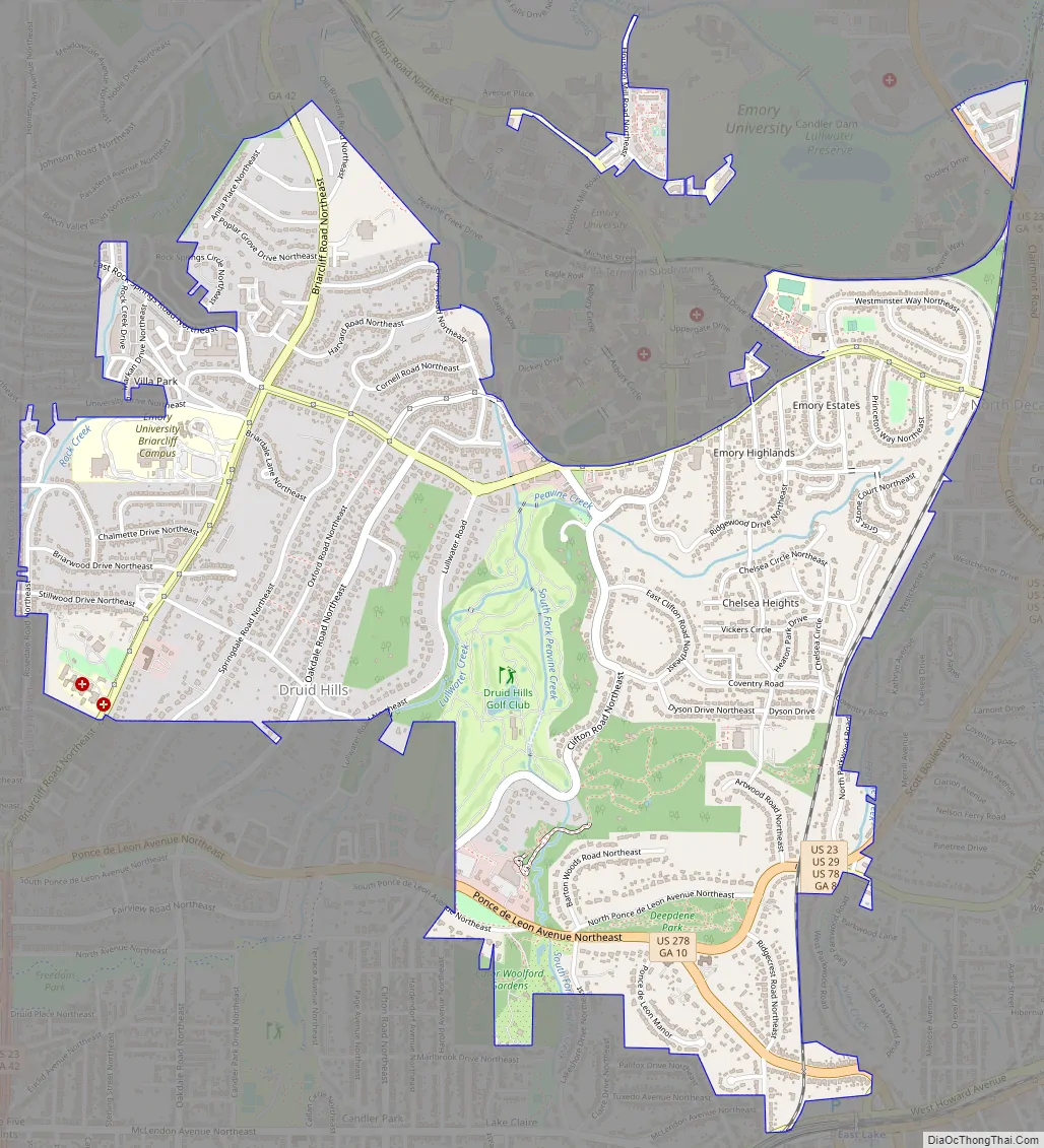
Online Interactive Map
Click on ![]() to view map in "full screen" mode.
to view map in "full screen" mode.
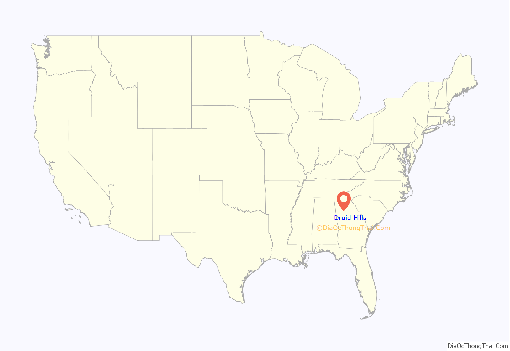
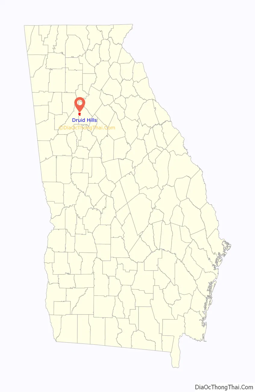
Druid Hills location map. Where is Druid Hills CDP?
History
The planned community was initially conceived by Joel Hurt, and developed with the effort of Atlanta’s leading families, including Coca-Cola founder Asa Candler. It contains some of Atlanta’s historic mansions from the late 19th and early 20th century. Druid Hills includes the main campus of Emory University, which relocated to Atlanta in 1914.
Druid Hills was designed by Frederick Law Olmsted and was one of his last commissions. A showpiece of the design was the string of parks along Ponce de Leon Avenue, which was designated as Druid Hills Parks and Parkways and listed on the National Register of Historic Places on April 11, 1975. The remainder of the development was listed on the Register as the Druid Hills Historic District on October 25, 1979. Later the Park and Parkways district was consolidated into the Druid Hills Historic District. The other historic districts in Druid Hills are:
- Emory University District, added in 1975
- University Park-Emory Highlands-Emory Estates Historic District, added in 1998
- Emory Grove Historic District, added in 2000.
By 2015 there was a bill in the Georgia Legislature which called for annexing more of Druid Hills into Atlanta.
Druid Hills Road Map
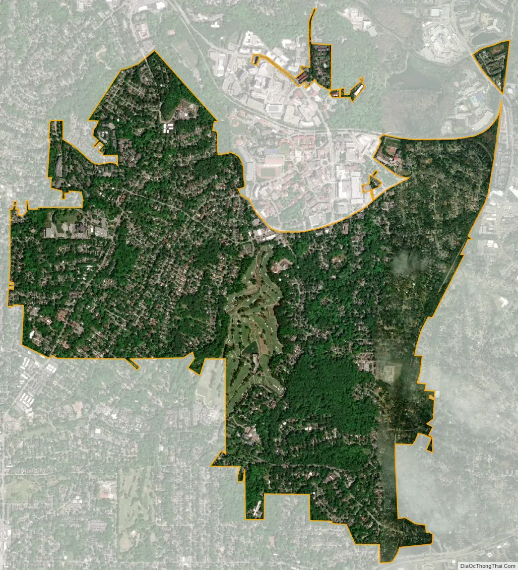
Druid Hills city Satellite Map
Geography
Druid Hills is located at 33°47′14″N 84°19′34″W / 33.78722°N 84.32611°W / 33.78722; -84.32611 (33.787205, -84.325974).
According to the United States Census Bureau, the CDP has a total area of 4.2 square miles (11 km), of which 0.04 square miles (0.10 km), or 0.48%, is water. The CDP’s northern boundary is the South Fork of Peachtree Creek; the CSX track and the Decatur city limits are the eastern boundary; the DeKalb County line is the western boundary; and the southern boundary is the Atlanta city limit.
The Druid Hills neighborhood of Atlanta is bounded by the Druid Hills CDP (i.e. unincorporated DeKalb County) on the north and east; the Morningside/Lenox Park, Virginia-Highland and Poncey-Highland neighborhoods of Atlanta on the west; and the Candler Park neighborhood of Atlanta on the south.
The Chelsea Heights neighborhood is located in the eastern part of the CDP at the Decatur border, and participates in the Druid Hills Civic Association.
See also
Map of Georgia State and its subdivision:- Appling
- Atkinson
- Bacon
- Baker
- Baldwin
- Banks
- Barrow
- Bartow
- Ben Hill
- Berrien
- Bibb
- Bleckley
- Brantley
- Brooks
- Bryan
- Bulloch
- Burke
- Butts
- Calhoun
- Camden
- Candler
- Carroll
- Catoosa
- Charlton
- Chatham
- Chattahoochee
- Chattooga
- Cherokee
- Clarke
- Clay
- Clayton
- Clinch
- Cobb
- Coffee
- Colquitt
- Columbia
- Cook
- Coweta
- Crawford
- Crisp
- Dade
- Dawson
- Decatur
- DeKalb
- Dodge
- Dooly
- Dougherty
- Douglas
- Early
- Echols
- Effingham
- Elbert
- Emanuel
- Evans
- Fannin
- Fayette
- Floyd
- Forsyth
- Franklin
- Fulton
- Gilmer
- Glascock
- Glynn
- Gordon
- Grady
- Greene
- Gwinnett
- Habersham
- Hall
- Hancock
- Haralson
- Harris
- Hart
- Heard
- Henry
- Houston
- Irwin
- Jackson
- Jasper
- Jeff Davis
- Jefferson
- Jenkins
- Johnson
- Jones
- Lamar
- Lanier
- Laurens
- Lee
- Liberty
- Lincoln
- Long
- Lowndes
- Lumpkin
- Macon
- Madison
- Marion
- McDuffie
- McIntosh
- Meriwether
- Miller
- Mitchell
- Monroe
- Montgomery
- Morgan
- Murray
- Muscogee
- Newton
- Oconee
- Oglethorpe
- Paulding
- Peach
- Pickens
- Pierce
- Pike
- Polk
- Pulaski
- Putnam
- Quitman
- Rabun
- Randolph
- Richmond
- Rockdale
- Schley
- Screven
- Seminole
- Spalding
- Stephens
- Stewart
- Sumter
- Talbot
- Taliaferro
- Tattnall
- Taylor
- Telfair
- Terrell
- Thomas
- Tift
- Toombs
- Towns
- Treutlen
- Troup
- Turner
- Twiggs
- Union
- Upson
- Walker
- Walton
- Ware
- Warren
- Washington
- Wayne
- Webster
- Wheeler
- White
- Whitfield
- Wilcox
- Wilkes
- Wilkinson
- Worth
- Alabama
- Alaska
- Arizona
- Arkansas
- California
- Colorado
- Connecticut
- Delaware
- District of Columbia
- Florida
- Georgia
- Hawaii
- Idaho
- Illinois
- Indiana
- Iowa
- Kansas
- Kentucky
- Louisiana
- Maine
- Maryland
- Massachusetts
- Michigan
- Minnesota
- Mississippi
- Missouri
- Montana
- Nebraska
- Nevada
- New Hampshire
- New Jersey
- New Mexico
- New York
- North Carolina
- North Dakota
- Ohio
- Oklahoma
- Oregon
- Pennsylvania
- Rhode Island
- South Carolina
- South Dakota
- Tennessee
- Texas
- Utah
- Vermont
- Virginia
- Washington
- West Virginia
- Wisconsin
- Wyoming