Johns Creek is a city in Fulton County, Georgia, United States. According to the 2020 census, the population was 82,453. The city is a northeastern suburb of Atlanta.
| Name: | Johns Creek city |
|---|---|
| LSAD Code: | 25 |
| LSAD Description: | city (suffix) |
| State: | Georgia |
| County: | Fulton County |
| Incorporated: | December 1, 2006 |
| Elevation: | 945 ft (288 m) |
| Total Area: | 31.34 sq mi (81.18 km²) |
| Land Area: | 30.81 sq mi (79.81 km²) |
| Water Area: | 0.53 sq mi (1.38 km²) |
| Total Population: | 82,453 |
| Population Density: | 2,675.92/sq mi (1,033.17/km²) |
| ZIP code: | None assigned to Johns Creek by USPS as it does not recognize the city. 30005, 30022, 30024, 30097, 30098 from other cities apply in various parts of Johns Creek. |
| Area code: | 770, 404, 678, 470 |
| FIPS code: | 1342425 |
| GNISfeature ID: | 2404806 |
| Website: | www.johnscreekga.gov |
Online Interactive Map
Click on ![]() to view map in "full screen" mode.
to view map in "full screen" mode.
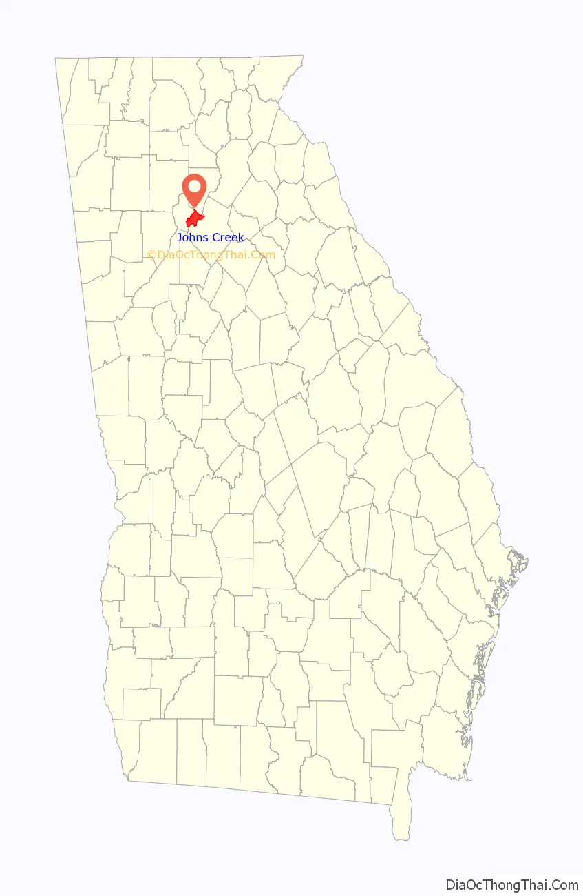
Johns Creek location map. Where is Johns Creek city?

History
In the early 19th century, the Johns Creek area was dotted with trading posts along the Chattahoochee River in what was then Cherokee territory. The Cherokee nation at the time was a confederacy of agrarian villages led by a chief. However, after Europeans colonized the area, the Cherokee developed an alphabet, and a legislature and judiciary system patterned after the American model.
Some trading posts gradually became crossroads communities where pioneer families – Rogers, McGinnis, Findley, Buice, Cowart, Medlock and others – gathered to visit and sell their crops.
By 1820, the community of Sheltonville (now known as Shakerag) was a ferry crossing site, with the McGinnis Ferry and Rogers Ferry carrying people and livestock across the river for a small fee. Further south, the Nesbit Ferry did the same near another crossroads community known as Newtown.
In the 1820s, the discovery of gold in the foothills of northeast Georgia within the Cherokee Nation – approximately 45 miles (72 km) north of today’s Johns Creek – led to America’s first Gold Rush, the eventual takeover of the Cherokee Nation by the U.S. government in 1830, and the subsequent forced exile (the “Trail of Tears”) of Cherokee Indians to Oklahoma and other areas of the American West.
A few Cherokees remained, the most famous being Sarah Cordery (1785–1842), the half-blood Cherokee wife of pioneer John Rogers (1774–1851), and their 12 children. Rogers was a respected, influential plantation owner and colleague of President Andrew Jackson. Rogers’s 1828 home – today, a private residence in Johns Creek – was an overnight stop-over for Jackson. Much later, the home was also visited by famed humorist Will Rogers, the great, great-nephew of John Rogers. Johns Creek’s name comes from John Rogers’s son, Johnson K. Rogers. A local tributary was named after him, and the name “Johns Creek” eventually came to be the name of the area.
In 1831, much of the land in the former Cherokee Nation north of the Chattahoochee was combined into the massive Cherokee County. When Milton County was formed in 1858, the Johns Creek area was folded into it.
In the 1930s, during the Great Depression, Milton County was dissolved and all of its land was then absorbed into Fulton County.
The four main crossroad communities — Ocee, Newtown, Shakerag and Warsaw — remained the social, educational and business centers of rural, unincorporated northeast Fulton County. For the next 50 years, these communities helped bring a sense of identity to this largely undeveloped and underpopulated area, as the nearby cities of Roswell, Alpharetta, Duluth and Suwanee and adjoining Forsyth and Gwinnett counties continued to grow and develop.
In 1981, a group of Georgia Institute of Technology graduates bought 1,700 acres (6.9 km) of farmland and woods near McGinnis Ferry and Medlock Bridge Roads for a high-tech office park. The new office park was to mirror one built in 1970 in nearby Peachtree Corners, known as Technology Park/Atlanta. Spotting tiny Johns Creek on an old map, they named their mixed-use, master-planned community “Technology Park/Johns Creek”. This is the first reference to Johns Creek as a place. The area grew over the years to become the home of 200 companies – many of them Fortune 500 firms – with nearly 11,000 people spread over 6,000,000 square feet (560,000 m) of office, retail and industrial space. With the jobs came houses and shopping centers, and the population increased to about 60,000.
By 2000, a grassroots movement to incorporate the Johns Creek area into a city was slowly developing. Residents wanted more control over issues such as traffic, growth, development and quality of life. They also sought a level of service that was a challenge for the sprawling Fulton County to provide. Following the nearby city of Sandy Springs’ successful incorporation in 2005, a legislative campaign was started to incorporate the Johns Creek community. House Bill 1321 was passed by the state legislature, signed by Gov. Sonny Perdue in March 2006, and approved by the residents of northeast Fulton County in a July 18, 2006 voter referendum. In November 2006, the city’s first elected officials were voted into office, with the City of Johns Creek becoming official December 1, 2006.
Newtown Elementary School, built in 1929, is Johns Creek’s only listing on the National Register of Historic Places. It was listed in August 2006, with location described as “near Alpharetta“, before Johns Creek’s incorporation was completed.
In 2017, an iHeartJC initiative has been growing to have the city’s residential, business and innovation ecosystem develop a long-term strength and identity in healthcare innovation and wellness. The resolution passed a year later. In 2022, the group was renamed Johns Creek Vitality.
Johns Creek Road Map
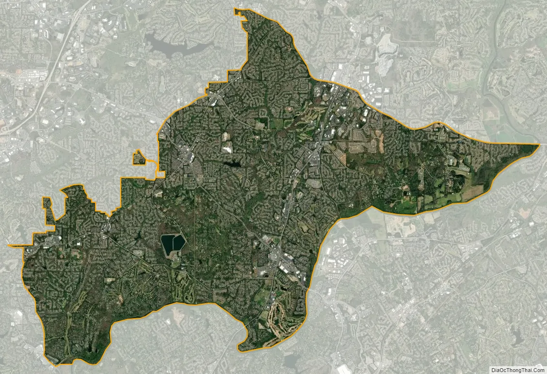
Johns Creek city Satellite Map
Geography
Johns Creek is located in northeastern Fulton County. The elevation ranges from 880 feet (270 m) above sea level along the Chattahoochee River to 1,180 feet (360 m) in the Ocee area along the Alpharetta border. Johns Creek is bounded to the south by the Chattahoochee River and Gwinnett County, and on the northeast by McGinnis Ferry Road and Forsyth County. It is bounded by Roswell to the west, Alpharetta to the northwest, Suwanee to the east, and Duluth, Berkeley Lake, and Peachtree Corners to the south. Downtown Atlanta is 27 miles (43 km) to the southwest.
According to the U.S. Census Bureau, the city of Johns Creek has a total area of 31.3 square miles (81.0 km), of which 30.7 square miles (79.6 km) is land and 0.54 square miles (1.4 km), or 1.76%, is water.
Climate
Johns Creek has a humid subtropical climate (Köppen climate classification Cfa).
See also
Map of Georgia State and its subdivision:- Appling
- Atkinson
- Bacon
- Baker
- Baldwin
- Banks
- Barrow
- Bartow
- Ben Hill
- Berrien
- Bibb
- Bleckley
- Brantley
- Brooks
- Bryan
- Bulloch
- Burke
- Butts
- Calhoun
- Camden
- Candler
- Carroll
- Catoosa
- Charlton
- Chatham
- Chattahoochee
- Chattooga
- Cherokee
- Clarke
- Clay
- Clayton
- Clinch
- Cobb
- Coffee
- Colquitt
- Columbia
- Cook
- Coweta
- Crawford
- Crisp
- Dade
- Dawson
- Decatur
- DeKalb
- Dodge
- Dooly
- Dougherty
- Douglas
- Early
- Echols
- Effingham
- Elbert
- Emanuel
- Evans
- Fannin
- Fayette
- Floyd
- Forsyth
- Franklin
- Fulton
- Gilmer
- Glascock
- Glynn
- Gordon
- Grady
- Greene
- Gwinnett
- Habersham
- Hall
- Hancock
- Haralson
- Harris
- Hart
- Heard
- Henry
- Houston
- Irwin
- Jackson
- Jasper
- Jeff Davis
- Jefferson
- Jenkins
- Johnson
- Jones
- Lamar
- Lanier
- Laurens
- Lee
- Liberty
- Lincoln
- Long
- Lowndes
- Lumpkin
- Macon
- Madison
- Marion
- McDuffie
- McIntosh
- Meriwether
- Miller
- Mitchell
- Monroe
- Montgomery
- Morgan
- Murray
- Muscogee
- Newton
- Oconee
- Oglethorpe
- Paulding
- Peach
- Pickens
- Pierce
- Pike
- Polk
- Pulaski
- Putnam
- Quitman
- Rabun
- Randolph
- Richmond
- Rockdale
- Schley
- Screven
- Seminole
- Spalding
- Stephens
- Stewart
- Sumter
- Talbot
- Taliaferro
- Tattnall
- Taylor
- Telfair
- Terrell
- Thomas
- Tift
- Toombs
- Towns
- Treutlen
- Troup
- Turner
- Twiggs
- Union
- Upson
- Walker
- Walton
- Ware
- Warren
- Washington
- Wayne
- Webster
- Wheeler
- White
- Whitfield
- Wilcox
- Wilkes
- Wilkinson
- Worth
- Alabama
- Alaska
- Arizona
- Arkansas
- California
- Colorado
- Connecticut
- Delaware
- District of Columbia
- Florida
- Georgia
- Hawaii
- Idaho
- Illinois
- Indiana
- Iowa
- Kansas
- Kentucky
- Louisiana
- Maine
- Maryland
- Massachusetts
- Michigan
- Minnesota
- Mississippi
- Missouri
- Montana
- Nebraska
- Nevada
- New Hampshire
- New Jersey
- New Mexico
- New York
- North Carolina
- North Dakota
- Ohio
- Oklahoma
- Oregon
- Pennsylvania
- Rhode Island
- South Carolina
- South Dakota
- Tennessee
- Texas
- Utah
- Vermont
- Virginia
- Washington
- West Virginia
- Wisconsin
- Wyoming