Limestone County is a county in the U.S. state of Texas. As of the 2020 census, its population was 22,146. Its county seat is Groesbeck. The county was created in 1846.
| Name: | Limestone County |
|---|---|
| FIPS code: | 48-293 |
| State: | Texas |
| Founded: | 1846 |
| Seat: | Groesbeck |
| Largest city: | Mexia |
| Total Area: | 933 sq mi (2,420 km²) |
| Land Area: | 905 sq mi (2,340 km²) |
| Total Population: | 22,146 |
| Population Density: | 24/sq mi (9.2/km²) |
| Time zone: | UTC−6 (Central) |
| Summer Time Zone (DST): | UTC−5 (CDT) |
| Website: | www.co.limestone.tx.us |
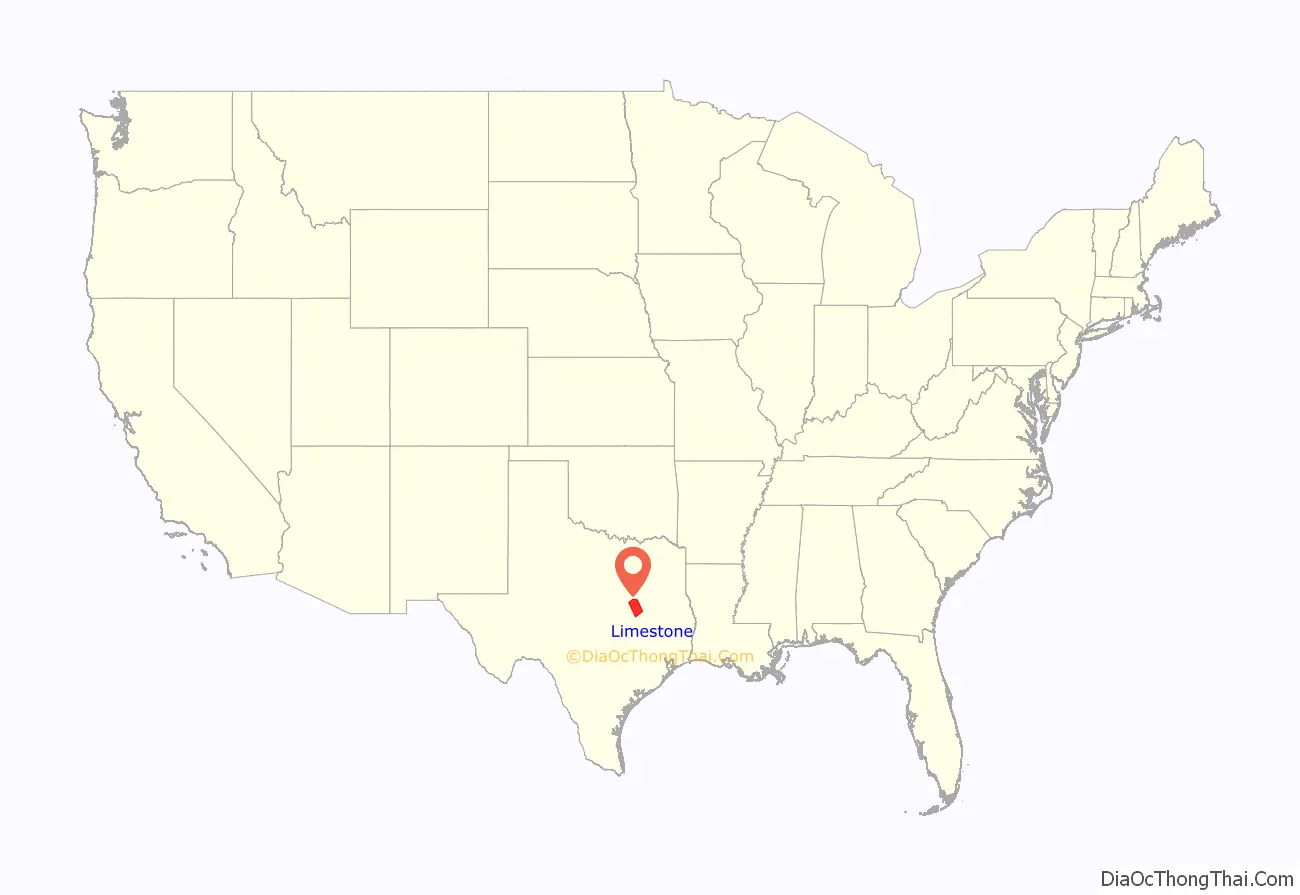
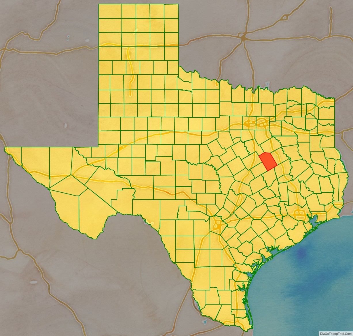
Limestone County location map. Where is Limestone County?
History
Native Americans
Indians friendly to the settlers resided in East Texas before the Kiowa, Apache and Comanche intruded upon their territory. These tribes hunted, farmed the land, and were adept traders. The Tawakoni branch of Wichita Indians originated north of Texas, but migrated south into east Texas. From 1843 onward, the Tawakoni were part of treaties made by both the Republic of Texas and the United States. Tawakoni were also sometimes known as Tehuacana. The Limestone County town of Tehuacana was settled on the former site of a Tehuacana village. The Waco people were also a branch of the Wichita Indians.
Arguably the most infamous Indian depredation in Texas took place in Limestone County on May 19, 1836, when an odd alliance of Comanche, Kiowa, Caddo, and Wichita approached Fort Parker surreptitiously under a flag of peace. The Indians subsequently attacked the fort, killing or kidnapping all but about 18 settlers who escaped to Fort Houston. Captured in the Fort Parker massacre were Elizabeth Kellogg, Rachel Plummer and her son James Pratt Plummer, John Richard Parker and his sister Cynthia Ann Parker, who later became mother of Comanche Chief Quanah Parker.
Settlers
Limestone County was part of the Haden Harrison Edwards (800 families) and Robertson’s Colony (800 families) empresario grants made by the Coahuila y Texas legislature in 1825. By contracting how many families each grantee could settle, the government sought to have some control over colonization.
Baptist spiritual leader Daniel Parker and eight other men organized the Pilgrim Predestinarian Regular Baptist Church in Lamotte, Illinois. The fellowship in its entirety migrated in 1833 to the new frontier of Texas. Among this group of settlers were Silas M. Parker, Moses Herrin, Elisha Anglin, Luther T. M. Plummer, David Faulkenberry, Joshua Hadley, and Samuel Frost. Fort Parker, near the Navasota River in what is now central Limestone County, was the earliest actual settlement in the vicinity. Following on the heels of the original settlers, other communities were established.
County established
On April 11, 1846, Limestone County was formed from Robertson County. On August 18, 1846, the county was organized. Springfield became the county seat. The county seat was moved to Groesbeck in 1873 after boundary changes, and the Springfield courthouse had burned down.
Homesteaders became self-sustaining farmers and ranchers, who also hunted wild game. Support businesses were connected to the repair and maintenance of farm equipment and livestock. The population of 1860 was 4,537. Of these, 3,464 were White, 1,072 were slaves, and one was a free Black female.
Civil War and Reconstruction
Limestone County voted 525–9 in favor of secession from the Union, and sent its men to fight for the Confederate States of America. Lochlin Johnson Farrar raised the first Confederate company from the county. Reconstruction in the county was so contentious, with racial violence and threats against the government, that on October 9, 1871, Texas Governor Edmund J. Davis declared the county under martial law.
Post-Civil War development
The Houston and Texas Central Railway laid tracks in 1869, terminating near Kosse which was named after the railway’s chief engineer Theodore Kosse. The Trinity and Brazos Valley Railway, laid track in 1903 from Cleburne to Mexia. Several towns were established on these routes.
The Thornton Institute was founded in 1877 by Edward Coke Chambers, and was chartered in 1881 as the Thornton Male and Female Institute. The school provided a type of dormitory for the students, and sent many graduates out to teach in rural Texas. Henry P. Davis acquired the school in 1889, and in 1891 the school was given to the Thornton Independent School District.
Oil and gas were discovered in Mexia between 1913 and 1920, creating jobs and a population boom – from just 3,482 people to 35,000 in 1922. Martial law had to be briefly declared in Mexia. The population began to decline during the Great Depression. Camp Mexia, a German prisoner of war camp was built during World War II.
The Work Projects Administration and the Civilian Conservation Corps helped ease the county economy during the Great Depression. The Civilian Conservation Corps built Fort Parker State Recreation Area. The WPA erected a number of buildings in the county.
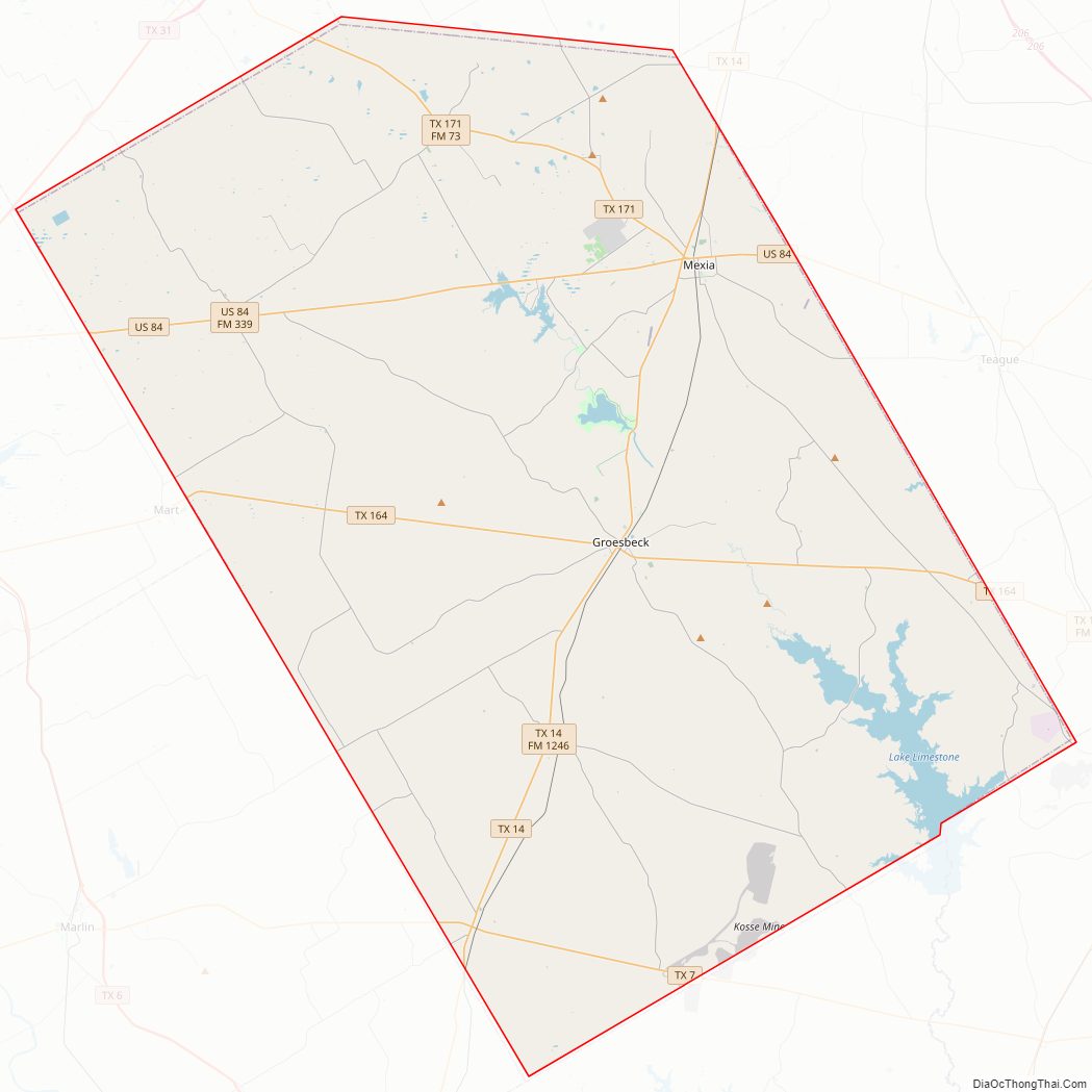
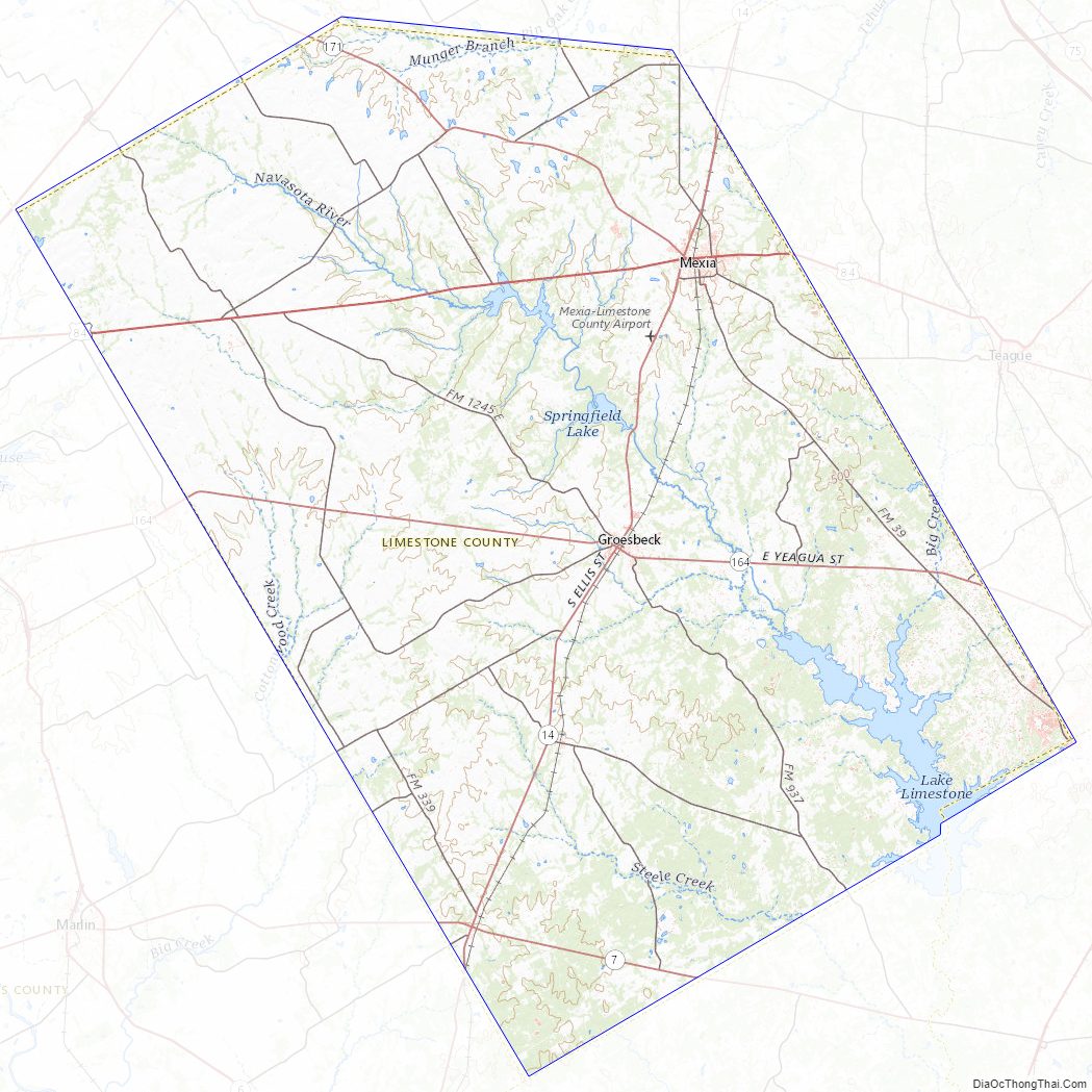
Limestone County Road Map
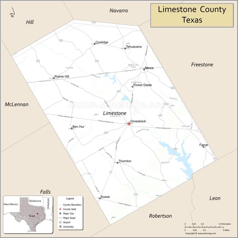
Geography
According to the U.S. Census Bureau, the county has a total area of 933 square miles (2,420 km), of which 905 square miles (2,340 km) are land and 28 square miles (73 km) (3.0%) are covered by water.
Major highways
- U.S. Highway 84
- State Highway 7
- State Highway 14
- State Highway 164
- State Highway 171
Adjacent counties
- Navarro County (north)
- Freestone County (northeast)
- Leon County (southeast)
- Robertson County (south)
- Falls County (southwest)
- McLennan County (west)
- Hill County (northwest)
Limestone County Topographic Map
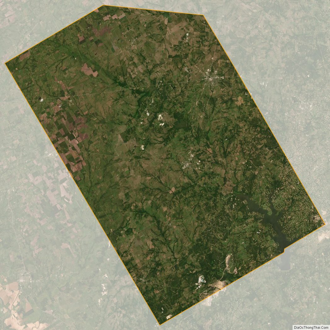
Limestone County Satellite Map
Limestone County Outline Map

See also
Map of Texas State and its subdivision:- Anderson
- Andrews
- Angelina
- Aransas
- Archer
- Armstrong
- Atascosa
- Austin
- Bailey
- Bandera
- Bastrop
- Baylor
- Bee
- Bell
- Bexar
- Blanco
- Borden
- Bosque
- Bowie
- Brazoria
- Brazos
- Brewster
- Briscoe
- Brooks
- Brown
- Burleson
- Burnet
- Caldwell
- Calhoun
- Callahan
- Cameron
- Camp
- Carson
- Cass
- Castro
- Chambers
- Cherokee
- Childress
- Clay
- Cochran
- Coke
- Coleman
- Collin
- Collingsworth
- Colorado
- Comal
- Comanche
- Concho
- Cooke
- Coryell
- Cottle
- Crane
- Crockett
- Crosby
- Culberson
- Dallam
- Dallas
- Dawson
- Deaf Smith
- Delta
- Denton
- Dewitt
- Dickens
- Dimmit
- Donley
- Duval
- Eastland
- Ector
- Edwards
- El Paso
- Ellis
- Erath
- Falls
- Fannin
- Fayette
- Fisher
- Floyd
- Foard
- Fort Bend
- Franklin
- Freestone
- Frio
- Gaines
- Galveston
- Garza
- Gillespie
- Glasscock
- Goliad
- Gonzales
- Gray
- Grayson
- Gregg
- Grimes
- Guadalupe
- Hale
- Hall
- Hamilton
- Hansford
- Hardeman
- Hardin
- Harris
- Harrison
- Hartley
- Haskell
- Hays
- Hemphill
- Henderson
- Hidalgo
- Hill
- Hockley
- Hood
- Hopkins
- Houston
- Howard
- Hudspeth
- Hunt
- Hutchinson
- Irion
- Jack
- Jackson
- Jasper
- Jeff Davis
- Jefferson
- Jim Hogg
- Jim Wells
- Johnson
- Jones
- Karnes
- Kaufman
- Kendall
- Kenedy
- Kent
- Kerr
- Kimble
- King
- Kinney
- Kleberg
- Knox
- La Salle
- Lamar
- Lamb
- Lampasas
- Lavaca
- Lee
- Leon
- Liberty
- Limestone
- Lipscomb
- Live Oak
- Llano
- Loving
- Lubbock
- Lynn
- Madison
- Marion
- Martin
- Mason
- Matagorda
- Maverick
- McCulloch
- McLennan
- McMullen
- Medina
- Menard
- Midland
- Milam
- Mills
- Mitchell
- Montague
- Montgomery
- Moore
- Morris
- Motley
- Nacogdoches
- Navarro
- Newton
- Nolan
- Nueces
- Ochiltree
- Oldham
- Orange
- Palo Pinto
- Panola
- Parker
- Parmer
- Pecos
- Polk
- Potter
- Presidio
- Rains
- Randall
- Reagan
- Real
- Red River
- Reeves
- Refugio
- Roberts
- Robertson
- Rockwall
- Runnels
- Rusk
- Sabine
- San Augustine
- San Jacinto
- San Patricio
- San Saba
- Schleicher
- Scurry
- Shackelford
- Shelby
- Sherman
- Smith
- Somervell
- Starr
- Stephens
- Sterling
- Stonewall
- Sutton
- Swisher
- Tarrant
- Taylor
- Terrell
- Terry
- Throckmorton
- Titus
- Tom Green
- Travis
- Trinity
- Tyler
- Upshur
- Upton
- Uvalde
- Val Verde
- Van Zandt
- Victoria
- Walker
- Waller
- Ward
- Washington
- Webb
- Wharton
- Wheeler
- Wichita
- Wilbarger
- Willacy
- Williamson
- Wilson
- Winkler
- Wise
- Wood
- Yoakum
- Young
- Zapata
- Zavala
- Alabama
- Alaska
- Arizona
- Arkansas
- California
- Colorado
- Connecticut
- Delaware
- District of Columbia
- Florida
- Georgia
- Hawaii
- Idaho
- Illinois
- Indiana
- Iowa
- Kansas
- Kentucky
- Louisiana
- Maine
- Maryland
- Massachusetts
- Michigan
- Minnesota
- Mississippi
- Missouri
- Montana
- Nebraska
- Nevada
- New Hampshire
- New Jersey
- New Mexico
- New York
- North Carolina
- North Dakota
- Ohio
- Oklahoma
- Oregon
- Pennsylvania
- Rhode Island
- South Carolina
- South Dakota
- Tennessee
- Texas
- Utah
- Vermont
- Virginia
- Washington
- West Virginia
- Wisconsin
- Wyoming