Wise County is a county in the U.S. state of Texas. As of the 2020 census, its population was 68,632. Its county seat is Decatur. Wise County is part of the Dallas–Fort Worth–Arlington metropolitan statistical area. Its Wise Eyes crime-watch program, eventually adopted by mostly rural counties in several states, was started in 1993 by then-Sheriff Phil Ryan.
| Name: | Wise County |
|---|---|
| FIPS code: | 48-497 |
| State: | Texas |
| Founded: | 1856 |
| Named for: | Henry Alexander Wise |
| Seat: | Decatur |
| Largest city: | Decatur |
| Total Area: | 923 sq mi (2,390 km²) |
| Land Area: | 904 sq mi (2,340 km²) |
| Total Population: | 68,632 |
| Population Density: | 74/sq mi (29/km²) |
| Time zone: | UTC−6 (Central) |
| Summer Time Zone (DST): | UTC−5 (CDT) |
| Website: | www.co.wise.tx.us |
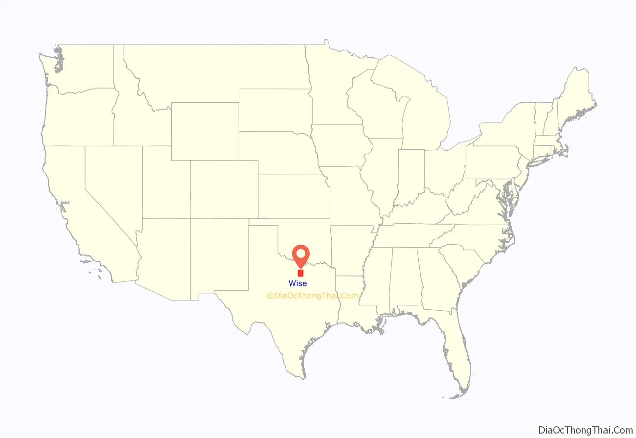
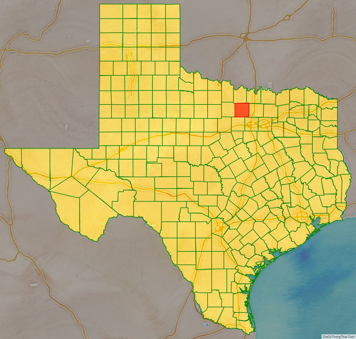
Wise County location map. Where is Wise County?
History
On November 10, 1837, the Battle of the Knobs was fought in what is now Wise County between about 150 Native American warriors and 18 Republic of Texas soldiers under Lieutenant A. B. Benthuysen. Despite being heavily outnumbered, the Texan soldiers held their ground, killing or wounding an estimated 50 Native Americans and losing 10 of their own men. More settlers began coming into the area not long afterward, with people relocating from both the Upper South and Deep South. Wise County was not founded until 1856. It was named after Virginia Congressman Henry A. Wise, who had supported annexation of Texas by the United States. He was elected governor of Virginia in 1856.
As few residents of Wise County were slaveholders, opinions were mixed at the time of the Civil War, and many people opposed secession. Unionists were persecuted in North Texas, and some were lynched. Forty-two men were murdered in the Great Hanging at Gainesville in October 1862, over the course of several days in neighboring Cooke County. This was one of the worst examples of vigilante justice in American history.
In recent years, Wise County allowed an increase in hydraulic fracturing. In 2011, the Parr family and others filed a lawsuit against several energy companies, including Republic Energy, Inc. and Ryder Scott Petroleum, claiming the extracting processes have created health complications for their family and neighbors. In April 2014, the Parrs won a $2.9 million award from a Dallas jury.
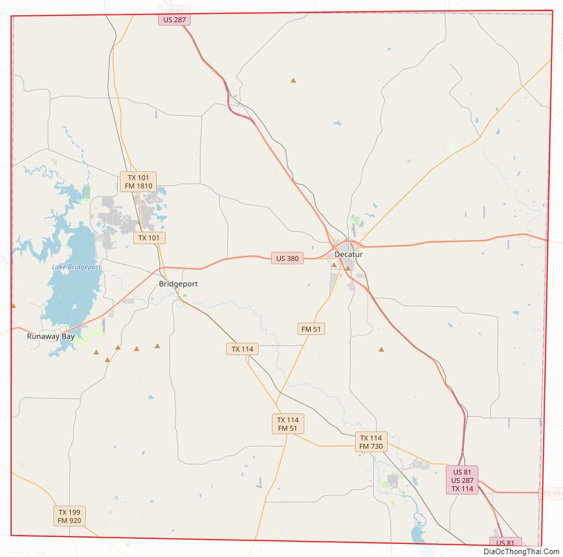
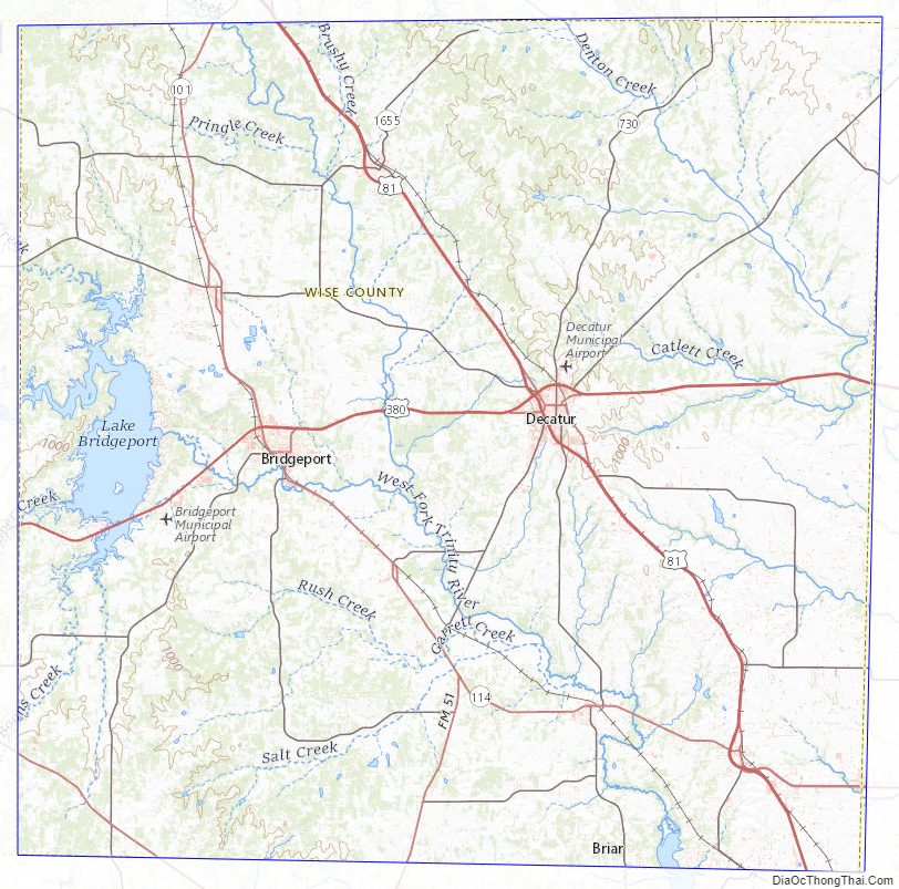
Wise County Road Map
Geography
According to the U.S. Census Bureau, the county has a total area of 923 sq mi (2,390 km), of which 18 sq mi (47 km) (2.0%) are covered by water.
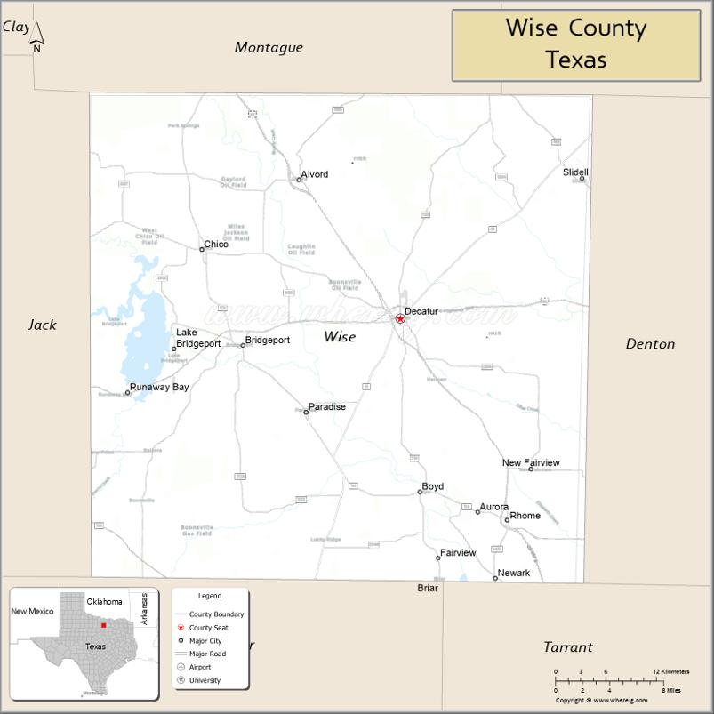
Adjacent counties
- Montague County (north)
- Cooke County (northeast)
- Denton County (east)
- Tarrant County (southeast)
- Parker County (south)
- Jack County (west)
National protected area
- Lyndon B. Johnson National Grassland (majority)
Wise County Topographic Map
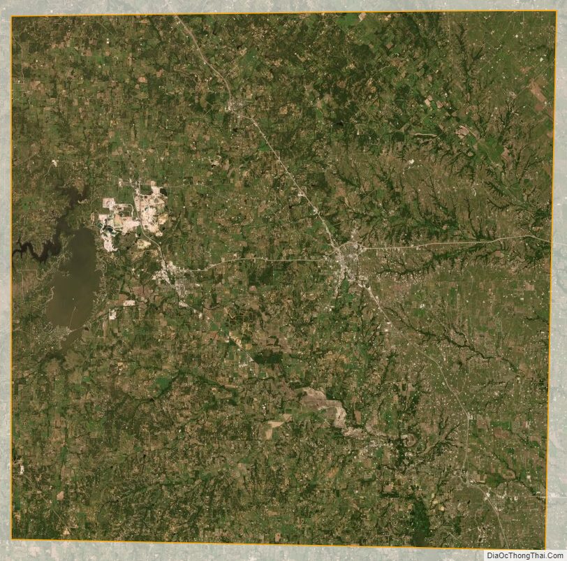
Wise County Satellite Map
Wise County Outline Map

See also
Map of Texas State and its subdivision:- Anderson
- Andrews
- Angelina
- Aransas
- Archer
- Armstrong
- Atascosa
- Austin
- Bailey
- Bandera
- Bastrop
- Baylor
- Bee
- Bell
- Bexar
- Blanco
- Borden
- Bosque
- Bowie
- Brazoria
- Brazos
- Brewster
- Briscoe
- Brooks
- Brown
- Burleson
- Burnet
- Caldwell
- Calhoun
- Callahan
- Cameron
- Camp
- Carson
- Cass
- Castro
- Chambers
- Cherokee
- Childress
- Clay
- Cochran
- Coke
- Coleman
- Collin
- Collingsworth
- Colorado
- Comal
- Comanche
- Concho
- Cooke
- Coryell
- Cottle
- Crane
- Crockett
- Crosby
- Culberson
- Dallam
- Dallas
- Dawson
- Deaf Smith
- Delta
- Denton
- Dewitt
- Dickens
- Dimmit
- Donley
- Duval
- Eastland
- Ector
- Edwards
- El Paso
- Ellis
- Erath
- Falls
- Fannin
- Fayette
- Fisher
- Floyd
- Foard
- Fort Bend
- Franklin
- Freestone
- Frio
- Gaines
- Galveston
- Garza
- Gillespie
- Glasscock
- Goliad
- Gonzales
- Gray
- Grayson
- Gregg
- Grimes
- Guadalupe
- Hale
- Hall
- Hamilton
- Hansford
- Hardeman
- Hardin
- Harris
- Harrison
- Hartley
- Haskell
- Hays
- Hemphill
- Henderson
- Hidalgo
- Hill
- Hockley
- Hood
- Hopkins
- Houston
- Howard
- Hudspeth
- Hunt
- Hutchinson
- Irion
- Jack
- Jackson
- Jasper
- Jeff Davis
- Jefferson
- Jim Hogg
- Jim Wells
- Johnson
- Jones
- Karnes
- Kaufman
- Kendall
- Kenedy
- Kent
- Kerr
- Kimble
- King
- Kinney
- Kleberg
- Knox
- La Salle
- Lamar
- Lamb
- Lampasas
- Lavaca
- Lee
- Leon
- Liberty
- Limestone
- Lipscomb
- Live Oak
- Llano
- Loving
- Lubbock
- Lynn
- Madison
- Marion
- Martin
- Mason
- Matagorda
- Maverick
- McCulloch
- McLennan
- McMullen
- Medina
- Menard
- Midland
- Milam
- Mills
- Mitchell
- Montague
- Montgomery
- Moore
- Morris
- Motley
- Nacogdoches
- Navarro
- Newton
- Nolan
- Nueces
- Ochiltree
- Oldham
- Orange
- Palo Pinto
- Panola
- Parker
- Parmer
- Pecos
- Polk
- Potter
- Presidio
- Rains
- Randall
- Reagan
- Real
- Red River
- Reeves
- Refugio
- Roberts
- Robertson
- Rockwall
- Runnels
- Rusk
- Sabine
- San Augustine
- San Jacinto
- San Patricio
- San Saba
- Schleicher
- Scurry
- Shackelford
- Shelby
- Sherman
- Smith
- Somervell
- Starr
- Stephens
- Sterling
- Stonewall
- Sutton
- Swisher
- Tarrant
- Taylor
- Terrell
- Terry
- Throckmorton
- Titus
- Tom Green
- Travis
- Trinity
- Tyler
- Upshur
- Upton
- Uvalde
- Val Verde
- Van Zandt
- Victoria
- Walker
- Waller
- Ward
- Washington
- Webb
- Wharton
- Wheeler
- Wichita
- Wilbarger
- Willacy
- Williamson
- Wilson
- Winkler
- Wise
- Wood
- Yoakum
- Young
- Zapata
- Zavala
- Alabama
- Alaska
- Arizona
- Arkansas
- California
- Colorado
- Connecticut
- Delaware
- District of Columbia
- Florida
- Georgia
- Hawaii
- Idaho
- Illinois
- Indiana
- Iowa
- Kansas
- Kentucky
- Louisiana
- Maine
- Maryland
- Massachusetts
- Michigan
- Minnesota
- Mississippi
- Missouri
- Montana
- Nebraska
- Nevada
- New Hampshire
- New Jersey
- New Mexico
- New York
- North Carolina
- North Dakota
- Ohio
- Oklahoma
- Oregon
- Pennsylvania
- Rhode Island
- South Carolina
- South Dakota
- Tennessee
- Texas
- Utah
- Vermont
- Virginia
- Washington
- West Virginia
- Wisconsin
- Wyoming