San Angelo (/sæn ˈændʒəloʊ/ SAN AN-jə-loh) is a city in and the county seat of Tom Green County, Texas, United States. Its location is in the Concho Valley, a region of Central Texas between the Permian Basin to the northwest, Chihuahuan Desert to the southwest, Osage Plains to the northeast, and Central Texas to the southeast. According to a 2019 Census estimate, San Angelo had a total population of 101,004. It is the principal city and center of the San Angelo metropolitan area, which had a population of 118,182.
San Angelo is home to Angelo State University, historic Fort Concho, and Goodfellow Air Force Base. It is the seat of the Roman Catholic Diocese of San Angelo.
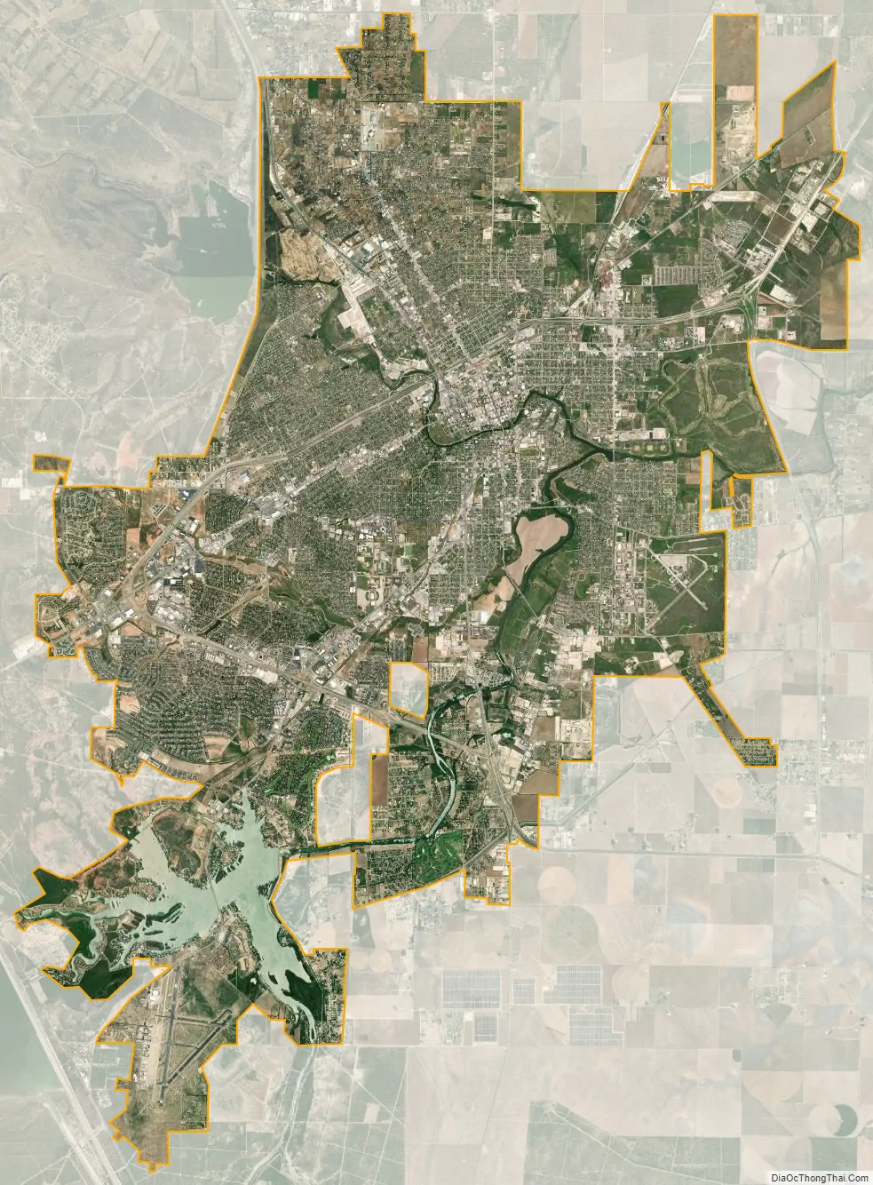
| Name: | San Angelo city |
|---|---|
| LSAD Code: | 25 |
| LSAD Description: | city (suffix) |
| State: | Texas |
| County: | Tom Green County |
| Elevation: | 1,844 ft (562 m) |
| Land Area: | 59.64 sq mi (154.46 km²) |
| Water Area: | 2.28 sq mi (5.91 km²) |
| Population Density: | 1,693.59/sq mi (653.90/km²) |
| ZIP code: | 76901-09 |
| Area code: | 325 |
| FIPS code: | 4864472 |
| GNISfeature ID: | 1375953 |
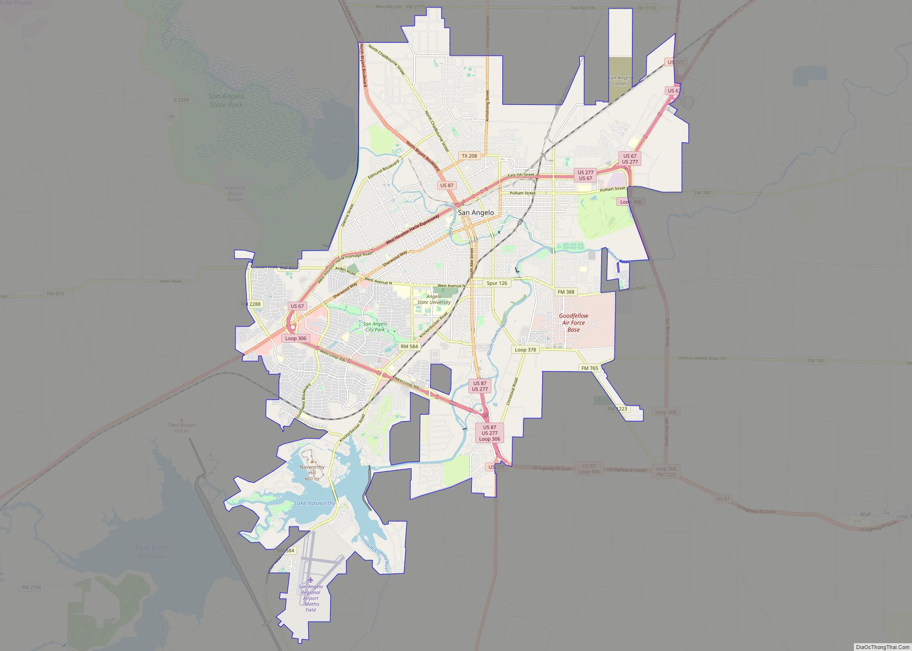
Online Interactive Map
Click on ![]() to view map in "full screen" mode.
to view map in "full screen" mode.
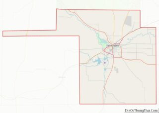
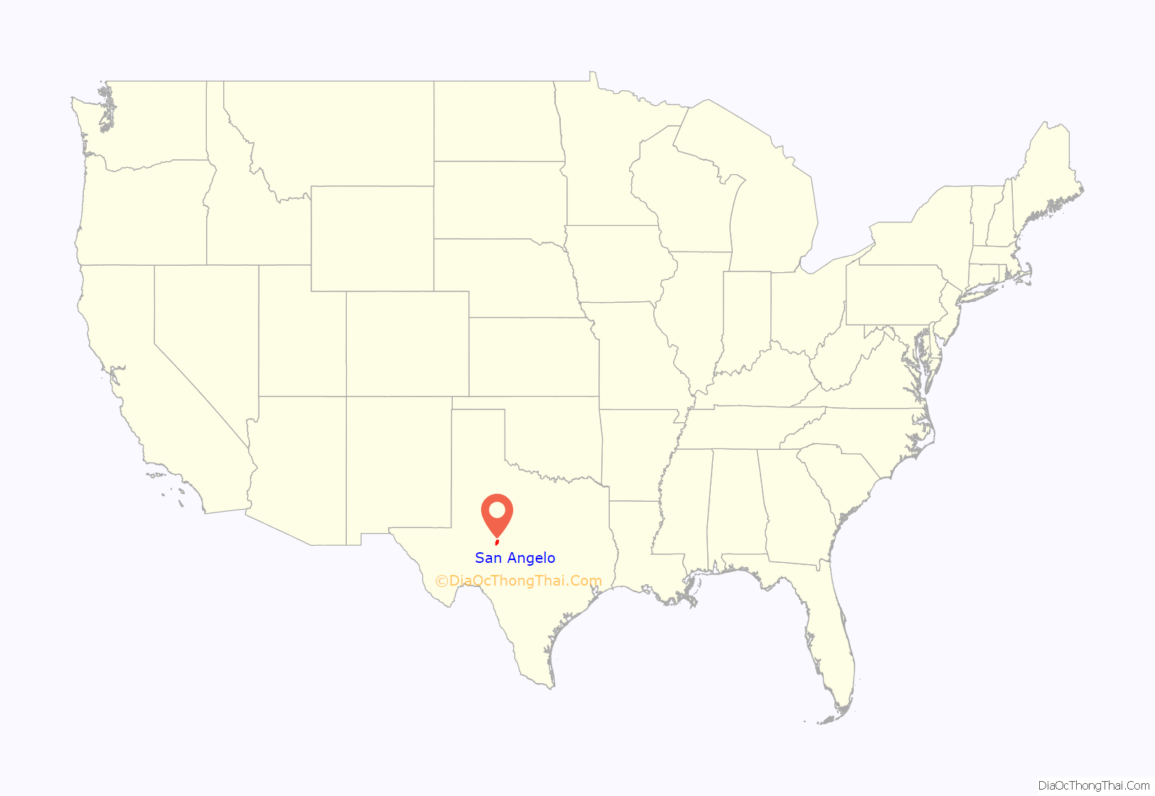
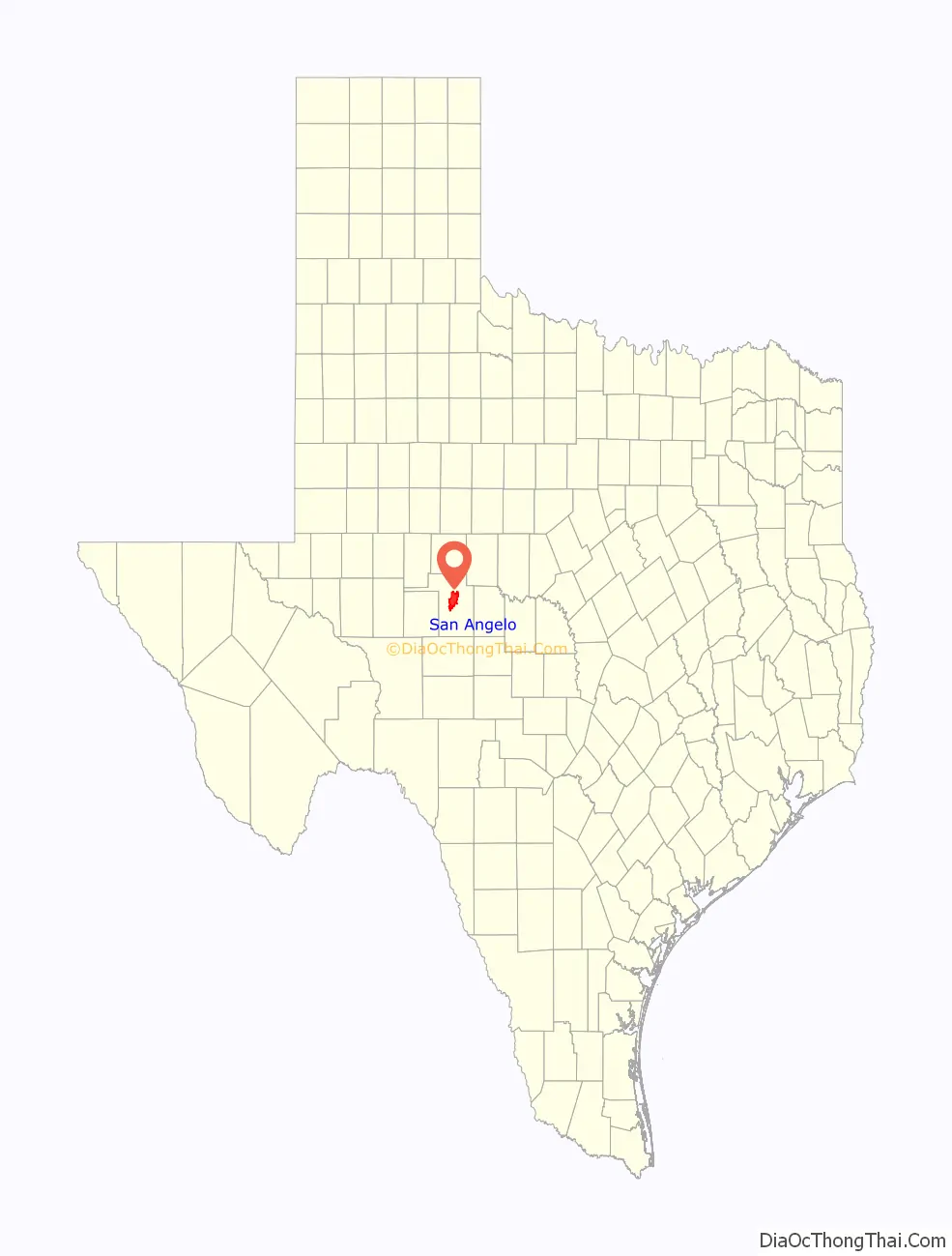
San Angelo location map. Where is San Angelo city?
History
In 1632, a short-lived mission of Franciscans under Spanish auspices was founded in the area to serve native people. The mission was led by the friars Juan de Salas and Juan de Ortega, with Ortega remaining for six months. The area was visited by the Castillo-Martin expedition of 1650 and the Diego de Guadalajara expedition of 1654.
During the development the region, San Angelo was at the western edge of the region called Texas, successively claimed in the 1800s by the nations of Spain, Mexico, the Republic of Texas, and finally, the United States in 1846.
The current city of San Angelo was founded in 1867, when the United States built Fort Concho, one of a series of new forts designed to protect the frontier. The fort was home to cavalry, infantry, and the famous Black Cavalry, also known as buffalo soldiers by American Indians.
The settler Bartholomew J. DeWitt founded the village of Santa Angela outside the fort at the junction of the North and South Concho Rivers. He named the village after his wife, Carolina Angela. The name was eventually changed to San Angela. The name would change again to San Angelo in 1883 on the insistence of the United States Postal Service, as San Angela was grammatically incorrect in Spanish. The town became a trade center for farmers and settlers in the area, as well as a fairly lawless cowtown filled with brothels, saloons, and gambling houses.
After being designated as the county seat, the town grew quickly in the 1880s, aided by being on the route of newly constructed railroads. It became a central transportation hub for the region. The Santa Fe Railroad arrived in 1888 and the Kansas City, Mexico and Orient Railway in 1909. After a tuberculosis (TB) outbreak hit the United States in the early 1900s, many patients moved to San Angelo. At the time, doctors could only recommend rest in dry, warm climates. TB sufferers went to San Angelo for treatment, and a sanitarium was built in nearby Carlsbad.
In 1928, the city founded San Angelo College, one of the region’s first institutes of higher education. The city had been passed over by the Texas State Legislature to be the home of what would become Texas Tech University. San Angelo College, one of the first municipal colleges, has grown to become Angelo State University. The military returned to San Angelo during World War II with the founding of Goodfellow Air Force Base, which was assigned to train pilots at the time. San Angelo grew exponentially during the oil boom of the 1900s, when vast amounts of oil were found in the area, and the city became a regional hub of the oil and gas industry.
The San Angelo Independent School District became one of the first in Texas to integrate, doing so voluntarily in 1955.
San Angelo was famous for Miss Wool of America Pageant, an annual event organized by the National Wool Growers Association (U.S.)
San Angelo Road Map
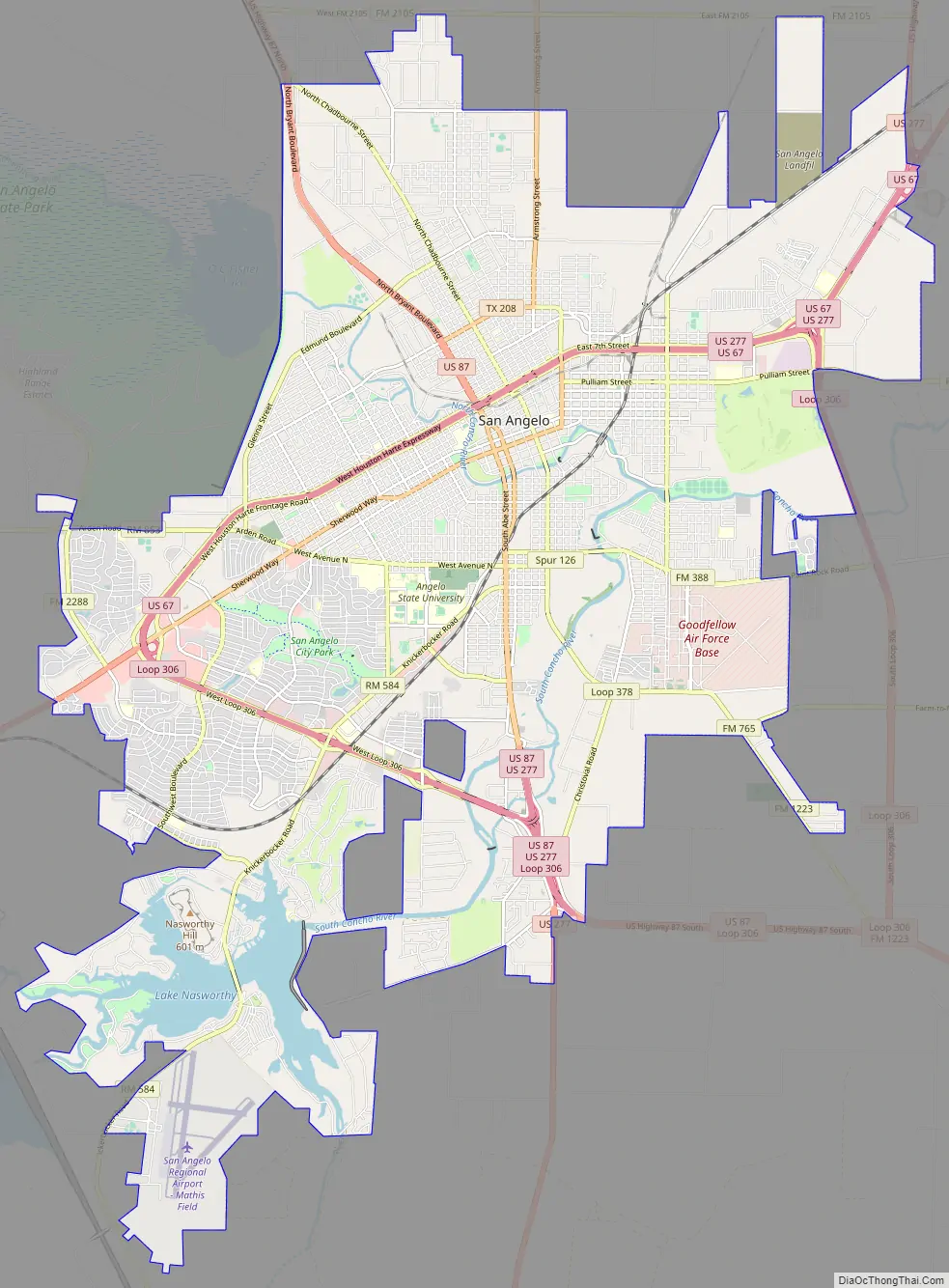
San Angelo city Satellite Map
Geography
According to the United States Census Bureau, the city has a total area of 58.2 sq mi (150.9 km), of which 2.3 sq mi (6.1 km) (4.03%) are covered by water.
San Angelo falls on the northwestern edge of the Edwards Plateau and the northeastern edge of the Chihuahuan Desert at the junction of the North and South Concho Rivers. The city has three lakes: Twin Buttes Reservoir, O.C. Fisher Reservoir, and Lake Nasworthy. The Middle Concho River joined the South Concho several miles upstream, but the confluence has been obscured by the Twin Buttes dam.
San Angelo is about 225 miles (362 km) west of Austin.
Climate
San Angelo falls near the boundary between the subtropical semiarid steppe (Köppen BSh) and midlatitude steppe climates (Köppen BSk). It is located at the region where Central Texas meets West Texas weather. Temperatures reach 100 °F (37.8 °C) about 18 times in a typical year. However, in 2011, San Angelo recorded 100 days of 100 °F (37.8 °C) or higher. The typical year has 50 days with lows below freezing. Though the region does experience snow and sleet, they occur only a few times a year. San Angelo averages 251 days of sunshine a year, and the average temperature is 65.4 °F (18.6 °C). The city has an average rainfall of 21.25 inches (540 mm), with the wettest calendar year since 1944 being 2016 with 35.72 inches (907.3 mm) and the driest 1956 with 7.41 inches (188.2 mm).
See also
Map of Texas State and its subdivision:- Anderson
- Andrews
- Angelina
- Aransas
- Archer
- Armstrong
- Atascosa
- Austin
- Bailey
- Bandera
- Bastrop
- Baylor
- Bee
- Bell
- Bexar
- Blanco
- Borden
- Bosque
- Bowie
- Brazoria
- Brazos
- Brewster
- Briscoe
- Brooks
- Brown
- Burleson
- Burnet
- Caldwell
- Calhoun
- Callahan
- Cameron
- Camp
- Carson
- Cass
- Castro
- Chambers
- Cherokee
- Childress
- Clay
- Cochran
- Coke
- Coleman
- Collin
- Collingsworth
- Colorado
- Comal
- Comanche
- Concho
- Cooke
- Coryell
- Cottle
- Crane
- Crockett
- Crosby
- Culberson
- Dallam
- Dallas
- Dawson
- Deaf Smith
- Delta
- Denton
- Dewitt
- Dickens
- Dimmit
- Donley
- Duval
- Eastland
- Ector
- Edwards
- El Paso
- Ellis
- Erath
- Falls
- Fannin
- Fayette
- Fisher
- Floyd
- Foard
- Fort Bend
- Franklin
- Freestone
- Frio
- Gaines
- Galveston
- Garza
- Gillespie
- Glasscock
- Goliad
- Gonzales
- Gray
- Grayson
- Gregg
- Grimes
- Guadalupe
- Hale
- Hall
- Hamilton
- Hansford
- Hardeman
- Hardin
- Harris
- Harrison
- Hartley
- Haskell
- Hays
- Hemphill
- Henderson
- Hidalgo
- Hill
- Hockley
- Hood
- Hopkins
- Houston
- Howard
- Hudspeth
- Hunt
- Hutchinson
- Irion
- Jack
- Jackson
- Jasper
- Jeff Davis
- Jefferson
- Jim Hogg
- Jim Wells
- Johnson
- Jones
- Karnes
- Kaufman
- Kendall
- Kenedy
- Kent
- Kerr
- Kimble
- King
- Kinney
- Kleberg
- Knox
- La Salle
- Lamar
- Lamb
- Lampasas
- Lavaca
- Lee
- Leon
- Liberty
- Limestone
- Lipscomb
- Live Oak
- Llano
- Loving
- Lubbock
- Lynn
- Madison
- Marion
- Martin
- Mason
- Matagorda
- Maverick
- McCulloch
- McLennan
- McMullen
- Medina
- Menard
- Midland
- Milam
- Mills
- Mitchell
- Montague
- Montgomery
- Moore
- Morris
- Motley
- Nacogdoches
- Navarro
- Newton
- Nolan
- Nueces
- Ochiltree
- Oldham
- Orange
- Palo Pinto
- Panola
- Parker
- Parmer
- Pecos
- Polk
- Potter
- Presidio
- Rains
- Randall
- Reagan
- Real
- Red River
- Reeves
- Refugio
- Roberts
- Robertson
- Rockwall
- Runnels
- Rusk
- Sabine
- San Augustine
- San Jacinto
- San Patricio
- San Saba
- Schleicher
- Scurry
- Shackelford
- Shelby
- Sherman
- Smith
- Somervell
- Starr
- Stephens
- Sterling
- Stonewall
- Sutton
- Swisher
- Tarrant
- Taylor
- Terrell
- Terry
- Throckmorton
- Titus
- Tom Green
- Travis
- Trinity
- Tyler
- Upshur
- Upton
- Uvalde
- Val Verde
- Van Zandt
- Victoria
- Walker
- Waller
- Ward
- Washington
- Webb
- Wharton
- Wheeler
- Wichita
- Wilbarger
- Willacy
- Williamson
- Wilson
- Winkler
- Wise
- Wood
- Yoakum
- Young
- Zapata
- Zavala
- Alabama
- Alaska
- Arizona
- Arkansas
- California
- Colorado
- Connecticut
- Delaware
- District of Columbia
- Florida
- Georgia
- Hawaii
- Idaho
- Illinois
- Indiana
- Iowa
- Kansas
- Kentucky
- Louisiana
- Maine
- Maryland
- Massachusetts
- Michigan
- Minnesota
- Mississippi
- Missouri
- Montana
- Nebraska
- Nevada
- New Hampshire
- New Jersey
- New Mexico
- New York
- North Carolina
- North Dakota
- Ohio
- Oklahoma
- Oregon
- Pennsylvania
- Rhode Island
- South Carolina
- South Dakota
- Tennessee
- Texas
- Utah
- Vermont
- Virginia
- Washington
- West Virginia
- Wisconsin
- Wyoming