Saint Jo is a city in Montague County, Texas, United States, along the northern border of the state. The population was 1,043 at the 2010 census.
| Name: | St. Jo city |
|---|---|
| LSAD Code: | 25 |
| LSAD Description: | city (suffix) |
| State: | Texas |
| County: | Montague County |
| Elevation: | 1,142 ft (348 m) |
| Total Area: | 1.08 sq mi (2.79 km²) |
| Land Area: | 1.08 sq mi (2.79 km²) |
| Water Area: | 0.00 sq mi (0.00 km²) |
| Total Population: | 1,043 |
| Population Density: | 957.25/sq mi (369.52/km²) |
| FIPS code: | 4864184 |
| GNISfeature ID: | 1367166 |
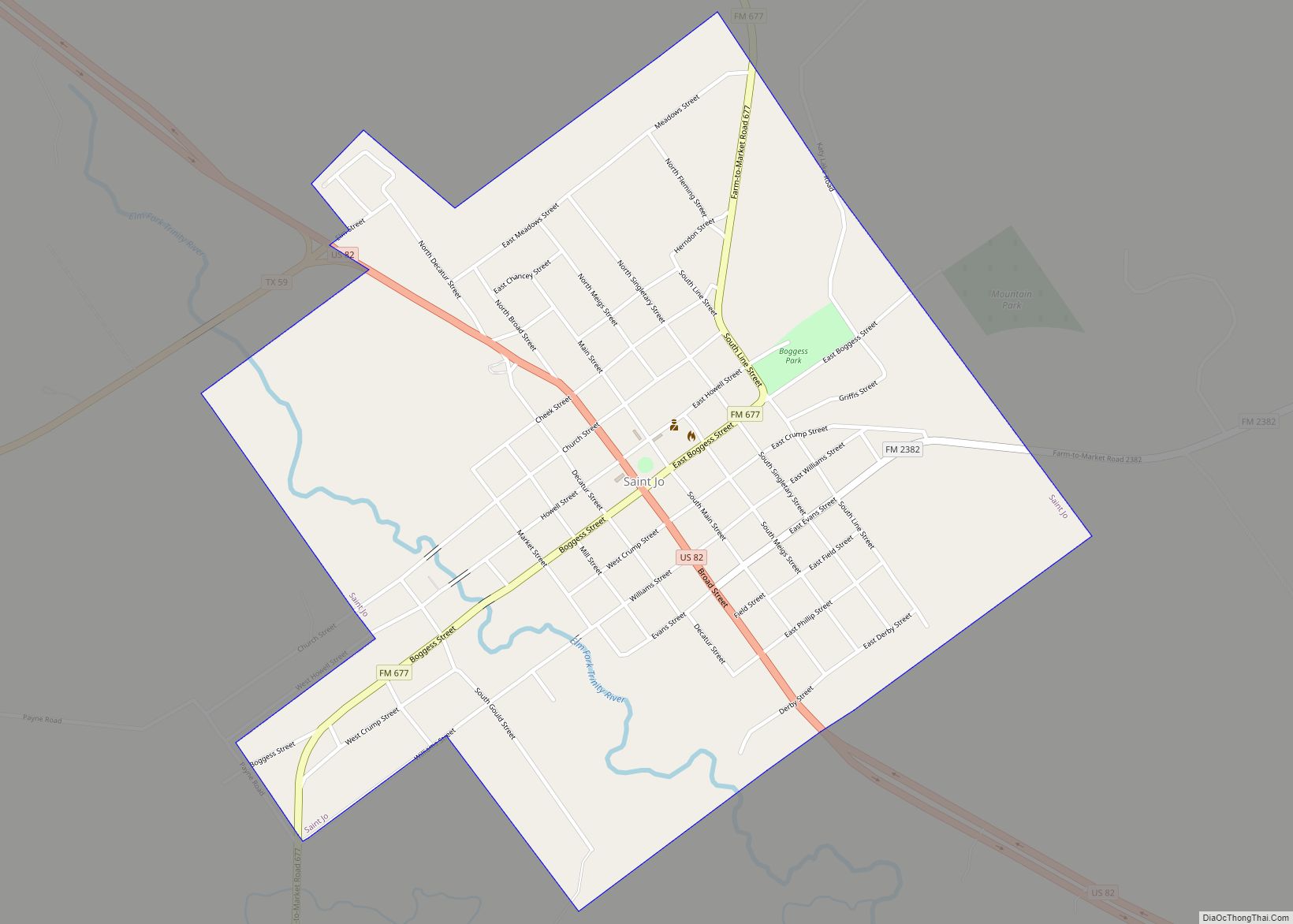
Online Interactive Map
Click on ![]() to view map in "full screen" mode.
to view map in "full screen" mode.
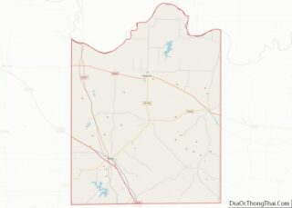
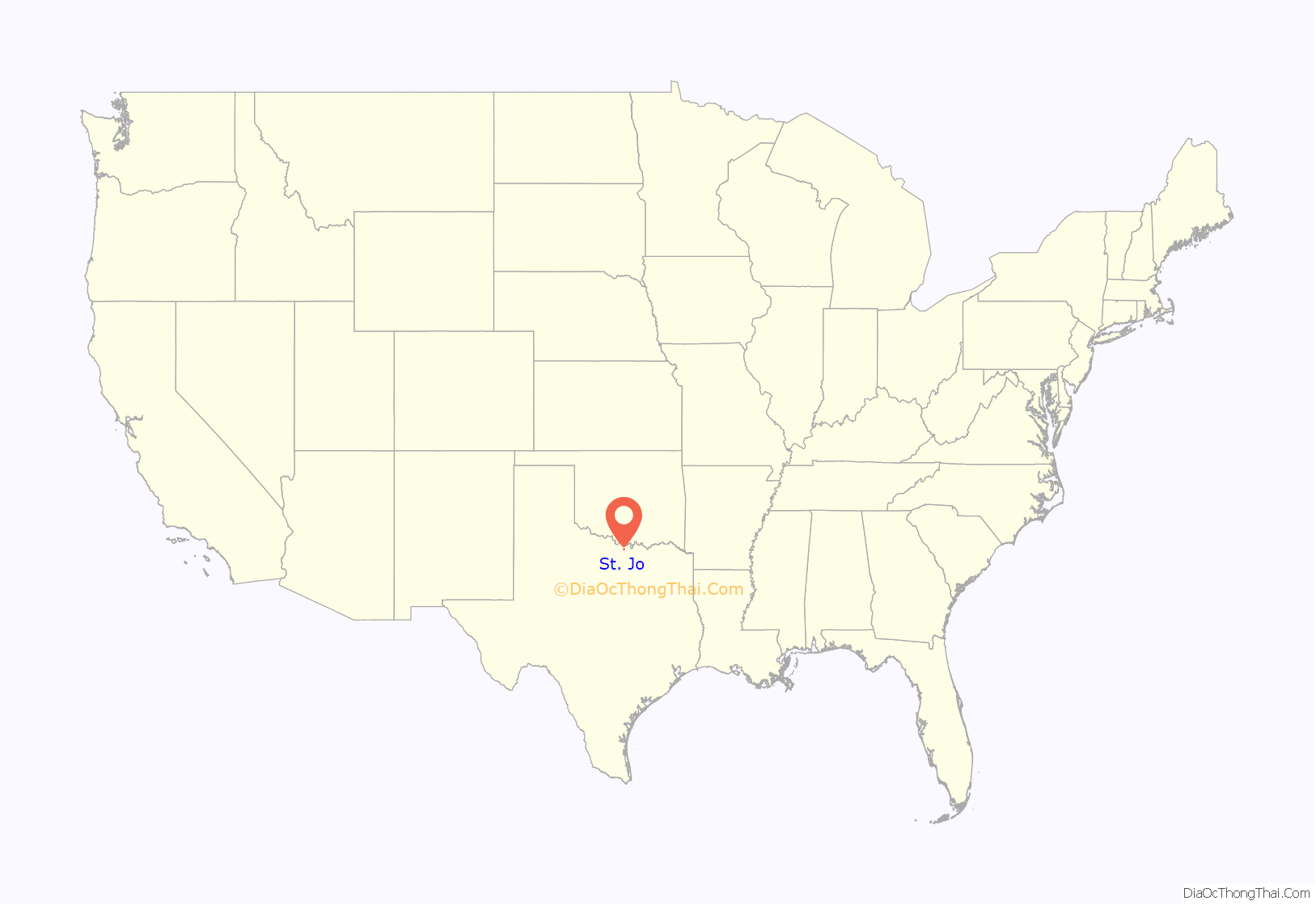
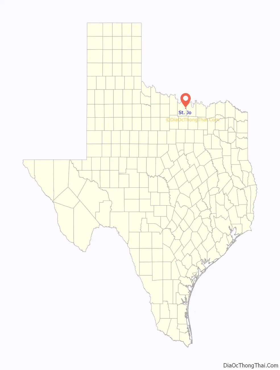
St. Jo location map. Where is St. Jo city?
History
Established by primarily European Americans in 1856, the city was originally known as Head of Elm, named for its location at the headwaters of the Elm Fork of the Trinity River, one of the four distinct headwaters. Numerous settlers came to this area from the Upper South of Tennessee and Kentucky, attracted to new opportunities in Texas.
Joe Howell was a surveyor who originally laid out the town and is credited as founder. According to one account, Irby Holt Boggess from Tennessee gave leadership in partnership with Howell in or around 1872. This account was displayed in 1986 in the Stonewall Saloon Museum on the town square of Saint Jo. It is incorporated in a story about Boggess.
Howell was said to have opposed alcoholic beverage sales, and was given the pejorative nickname “Saint Jo.” This was also applied to the town he founded. But in 1880 Zachariah T. Haden, who had come from Paducah, Kentucky with his family, was working as a saloon keeper in Saint Jo, perhaps at the Stonewall Saloon.
Saint Jo was located near Red River Station, a trading post on the Red River. In the post-Civil War period, this post became the southern terminus of the Chisholm Trail. As ranchers undertook cattle drives to get their cattle to railheads in Kansas and then shipped East, where they could command high prices, the areas related to the trail began to develop increased populations and businesses. Cowboys were the chief customers for saloons and hotels in these towns. Eventually railroads were constructed into Texas, ending the cattle drives to Kansas, and drawing off business along the trail.
After the United States’ 20th-century Prohibition era, from 1920 to 1933, Saint Jo voted to remain a “dry” city. It was not until May 2009 that residents voted to allow the sale of alcoholic beverages for off-premises consumption.
Saint Jo has been proud of its Western heritage and encourages tourism related to it. For instance, the Stonewall Saloon has been preserved for use as a museum, and the main street has retained its late 19th-century character.
On May 6, 2017, the Real Chisholm Trail Symposium met in Saint Jo. Program participants included representatives of the West Texas Historical Association, the Trail Drivers Association, and the Fort Sill Museum in Fort Sill, Oklahoma. Gary and Margaret Kraisinger, the joint authors of the 2004 book The Western: The Greatest Texas Cattle Trail, 1874–1886, also appeared.
The city holds BoHo Saint Jo semiannually, a collaborative event produced with the retail clothing store Panache. The event features local vendors who can showcase their locally sourced goods.
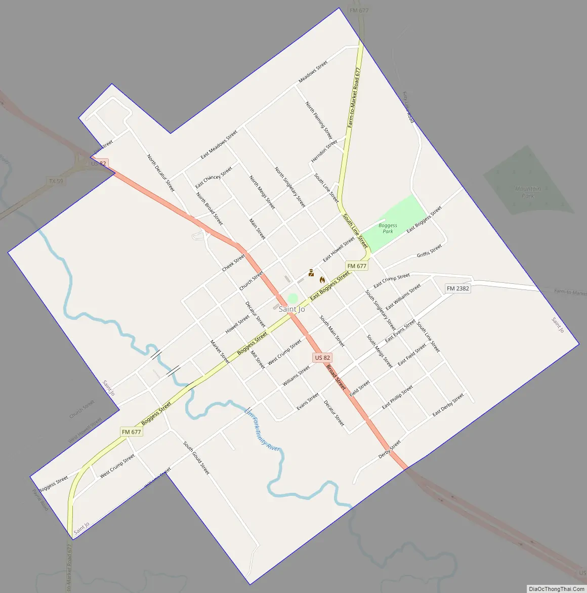
St. Jo Road Map
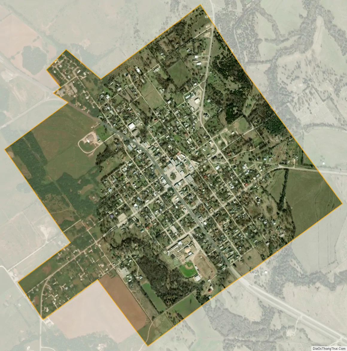
St. Jo city Satellite Map
Geography
Saint Jo is located at 33°41′41″N 97°31′25″W / 33.69472°N 97.52361°W / 33.69472; -97.52361 (33.694829, –97.523488).
According to the United States Census Bureau, the city has a total area of 1.1 square miles (2.8 km), all of it land.
See also
Map of Texas State and its subdivision:- Anderson
- Andrews
- Angelina
- Aransas
- Archer
- Armstrong
- Atascosa
- Austin
- Bailey
- Bandera
- Bastrop
- Baylor
- Bee
- Bell
- Bexar
- Blanco
- Borden
- Bosque
- Bowie
- Brazoria
- Brazos
- Brewster
- Briscoe
- Brooks
- Brown
- Burleson
- Burnet
- Caldwell
- Calhoun
- Callahan
- Cameron
- Camp
- Carson
- Cass
- Castro
- Chambers
- Cherokee
- Childress
- Clay
- Cochran
- Coke
- Coleman
- Collin
- Collingsworth
- Colorado
- Comal
- Comanche
- Concho
- Cooke
- Coryell
- Cottle
- Crane
- Crockett
- Crosby
- Culberson
- Dallam
- Dallas
- Dawson
- Deaf Smith
- Delta
- Denton
- Dewitt
- Dickens
- Dimmit
- Donley
- Duval
- Eastland
- Ector
- Edwards
- El Paso
- Ellis
- Erath
- Falls
- Fannin
- Fayette
- Fisher
- Floyd
- Foard
- Fort Bend
- Franklin
- Freestone
- Frio
- Gaines
- Galveston
- Garza
- Gillespie
- Glasscock
- Goliad
- Gonzales
- Gray
- Grayson
- Gregg
- Grimes
- Guadalupe
- Hale
- Hall
- Hamilton
- Hansford
- Hardeman
- Hardin
- Harris
- Harrison
- Hartley
- Haskell
- Hays
- Hemphill
- Henderson
- Hidalgo
- Hill
- Hockley
- Hood
- Hopkins
- Houston
- Howard
- Hudspeth
- Hunt
- Hutchinson
- Irion
- Jack
- Jackson
- Jasper
- Jeff Davis
- Jefferson
- Jim Hogg
- Jim Wells
- Johnson
- Jones
- Karnes
- Kaufman
- Kendall
- Kenedy
- Kent
- Kerr
- Kimble
- King
- Kinney
- Kleberg
- Knox
- La Salle
- Lamar
- Lamb
- Lampasas
- Lavaca
- Lee
- Leon
- Liberty
- Limestone
- Lipscomb
- Live Oak
- Llano
- Loving
- Lubbock
- Lynn
- Madison
- Marion
- Martin
- Mason
- Matagorda
- Maverick
- McCulloch
- McLennan
- McMullen
- Medina
- Menard
- Midland
- Milam
- Mills
- Mitchell
- Montague
- Montgomery
- Moore
- Morris
- Motley
- Nacogdoches
- Navarro
- Newton
- Nolan
- Nueces
- Ochiltree
- Oldham
- Orange
- Palo Pinto
- Panola
- Parker
- Parmer
- Pecos
- Polk
- Potter
- Presidio
- Rains
- Randall
- Reagan
- Real
- Red River
- Reeves
- Refugio
- Roberts
- Robertson
- Rockwall
- Runnels
- Rusk
- Sabine
- San Augustine
- San Jacinto
- San Patricio
- San Saba
- Schleicher
- Scurry
- Shackelford
- Shelby
- Sherman
- Smith
- Somervell
- Starr
- Stephens
- Sterling
- Stonewall
- Sutton
- Swisher
- Tarrant
- Taylor
- Terrell
- Terry
- Throckmorton
- Titus
- Tom Green
- Travis
- Trinity
- Tyler
- Upshur
- Upton
- Uvalde
- Val Verde
- Van Zandt
- Victoria
- Walker
- Waller
- Ward
- Washington
- Webb
- Wharton
- Wheeler
- Wichita
- Wilbarger
- Willacy
- Williamson
- Wilson
- Winkler
- Wise
- Wood
- Yoakum
- Young
- Zapata
- Zavala
- Alabama
- Alaska
- Arizona
- Arkansas
- California
- Colorado
- Connecticut
- Delaware
- District of Columbia
- Florida
- Georgia
- Hawaii
- Idaho
- Illinois
- Indiana
- Iowa
- Kansas
- Kentucky
- Louisiana
- Maine
- Maryland
- Massachusetts
- Michigan
- Minnesota
- Mississippi
- Missouri
- Montana
- Nebraska
- Nevada
- New Hampshire
- New Jersey
- New Mexico
- New York
- North Carolina
- North Dakota
- Ohio
- Oklahoma
- Oregon
- Pennsylvania
- Rhode Island
- South Carolina
- South Dakota
- Tennessee
- Texas
- Utah
- Vermont
- Virginia
- Washington
- West Virginia
- Wisconsin
- Wyoming