Bellaire is a city in southwest Harris County, Texas, United States, within the Houston–Sugar Land–Baytown metropolitan area. As of the 2020 U.S. census, the city population was 17,202. It is surrounded by the cities of Houston and West University Place. Bellaire is known as the “City of Homes”, owing to its mostly residential character; but it has offices along the I-610 Loop within the city limits.
| Name: | Bellaire city |
|---|---|
| LSAD Code: | 25 |
| LSAD Description: | city (suffix) |
| State: | Texas |
| County: | Harris County |
| Incorporated: | June 24, 1918 |
| Elevation: | 52 ft (16 m) |
| Total Area: | 3.60 sq mi (9.32 km²) |
| Land Area: | 3.60 sq mi (9.32 km²) |
| Water Area: | 0.00 sq mi (0.00 km²) |
| Total Population: | 17,202 |
| Population Density: | 5,274.12/sq mi (2,036.44/km²) |
| ZIP code: | 77401-77402 |
| FIPS code: | 4807300 |
| GNISfeature ID: | 1330381 |
Online Interactive Map
Click on ![]() to view map in "full screen" mode.
to view map in "full screen" mode.
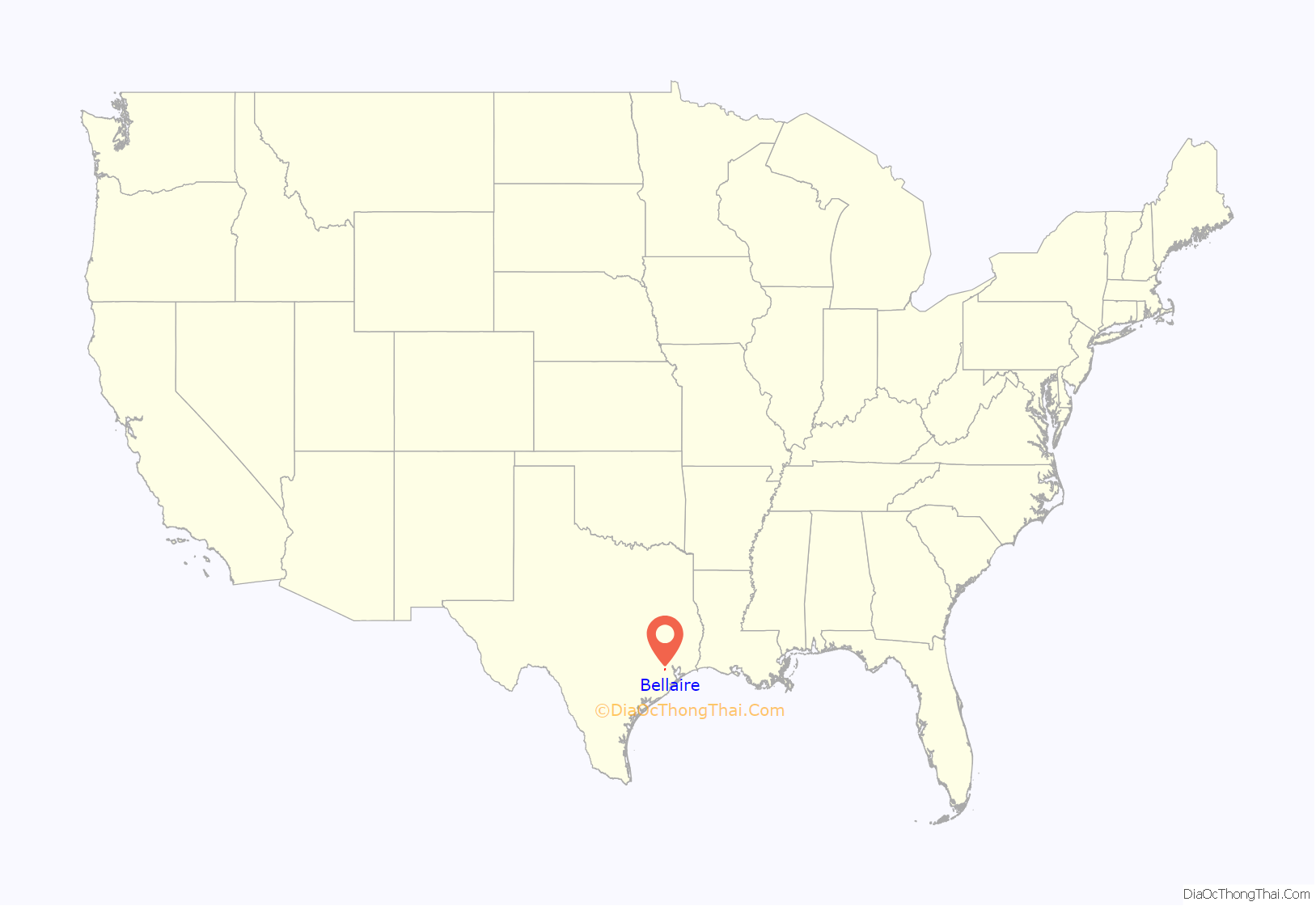
Bellaire location map. Where is Bellaire city?
History
Bellaire was founded in 1908 by William Wright Baldwin, who was the president of the South End Land Company. Baldwin, a native of Iowa, was well known as the vice president of the Burlington Railroad. Bellaire was founded on what was part of William Marsh Rice’s 9,449 acres (38.24 km) ranch. Baldwin surveyed the eastern 1,000 acres (4.0 km) of the ranch into small truck farms. He named them “Westmoreland Farms”. Baldwin started Bellaire in the middle of “Westmoreland Farms” to serve as a residential neighborhood and an agricultural trading center. South End Land Company advertised to farmers in the Midwestern United States. Baldwin stated that the town was named “Bellaire”, or “Good Air” for its breezes. Bellaire may have been named after Bellaire, Ohio, a town served by one of Baldwin’s rail lines.
Six miles of prairie were a buffer zone between Houston and Bellaire. Originally, the town was bounded by Palmetto, First, Jessamine, and Sixth (now Ferris) Streets. In 1910, Edward Teas, a horticulturist, moved his nursery to Bellaire from Missouri so he could implement Sid Hare’s landscaping plans. Bellaire was incorporated as a city with a general charter in 1918, 10 years after its founding. Bellaire had a population of 200 at the time. Because of the 1918 incorporation, Houston did not incorporate Bellaire’s territory into its city limits, while annexing surrounding areas that were unincorporated.
Bellaire’s population had reached 1,124 in 1940. After 1940, Bellaire had a rapid population explosion in the post-World War II building boom. On December 31, 1948, the city of Houston had annexed the land around the city of Bellaire, stopping the city of Bellaire’s land growth. Bellaire remained independent of Houston, and adopted a home rule charter with a council-manager government in April 1949. By 1950, the city’s residents had numbered 10,173, with 3,186 houses. Each subsequent year for the next two years, though, an additional 600 to 700 new houses were added. Due to the resulting population increase, several schools, including Bellaire High School, Marian High School, and two elementary schools, were established in that period, and Condit Elementary received a new addition. In the 1960s, 250 houses in Bellaire were demolished to make way for the right-of-way of the I-610 Loop, which bisected the city.
According to a Bellaire resident quoted in the Houston Post, prior to 1992, the tax base of the city of Bellaire had been decreasing. After neighbor West University Place eased restrictions on developers, new houses were constructed in West University Place, and the city gained a larger tax base. Bellaire decided to also liberalize its development restrictions to allow for new development by streamlining its no-growth building permit process. According to Karl Lewis, a vice president and sales manager at John Daugherty Realtors, when the prices of West University Place land reached about $20/sq ft, area home buyers began to consider Bellaire, which had an average price of $10–12/sq ft. Don Stowers of the Houston Press said that Bellaire and West University Place had “comparable” attributes such as independent fire and police departments, zoning, recreation facilities and parks, and schools “among the best in Houston.” Michael Blum, president of Blum & Associates Realty, said “Bellaire is a bargain.” Blum added that Bellaire was affordable compared to similar American neighborhoods and that Bellaire had proximity to business districts, “excellent” municipal services, and “superior” schools. Affluent families increasingly moved to Bellaire. The price of an average house in Bellaire increased from $75,000 to $500,000 from 1986 to 2006.
In 2002, the City of Bellaire attempted to acquire all or part of the 10 acres (4.0 ha) Teas Nursery, Bellaire’s oldest business and the oldest nursery in Greater Houston, for park development. The company fought the city’s take-over attempt. During that year the owners of Teas sold 5 acres (2.0 ha) at the rear of the property to Lovett Homes, a home developer. Frank Liu, the owner of Lovett Homes, said that it had an option to buy the remaining 5 acres (20,000 m). When the City of Bellaire denied a replat application sent by Teas Nursery, in June 2002 the nursery filed a lawsuit against the city and its zoning commission. In 2005 the lawsuit was settled out of court.
During the Hurricane Rita evacuation, a bus filled with residents from Brighton Gardens, a nursing home in Bellaire, caught on fire and exploded in the city of Wilmer. The September 23, 2005, explosion killed 24 of the 38 residents and employees on the bus. The resulting lawsuit was settled in June 2009. On March 23, 2008, a tour bus carrying Tejano singer Emilio Navaira crashed in Bellaire. By 2008, an increasing number of houses sold for over $1,000,000.
On December 31, 2008, Bellaire police officers confronted Robbie Tolan, the son of former Major League Baseball player Bobby Tolan, in the driveway of his house at the 800 block of Woodstock. Officers suspected Tolan, who was unarmed, of stealing a sports utility vehicle in the driveway and shot Tolan in the chest; Tolan’s family owned the vehicle. Tolan was hospitalized with injuries to one lung and his liver. The incident sparked allegations of racial profiling. Members of minority groups reported that Bellaire police racially profiled people. In 2002, José Cruz Jr., son of baseball player José Cruz, was stopped since his vehicle was missing a front license plate. He was arrested by Bellaire police and spent one night in jail after Bellaire law enforcement told him that he had a warrant for his arrest. The Houston Chronicle said that the Bellaire police decision to arrest Cruz was a mistake. In January 2009, Cruz accused the police of racial profiling. Mayor Cindy Siegel said that she was unaware of racial profiling by police. Siegel announced that the city will investigate racial profiling and hire an independent consultant to look at traffic stop data. The local National Association for the Advancement of Colored People (NAACP) branch said that it established a pact with the City of Bellaire; people may report civil rights violations from Bellaire Police to the branch if the people do not wish to contact the City of Bellaire. However, the NAACP branch has not yet provided the city with any civil rights violations. On April 6, 2009, a Harris County grand jury indicted Sergeant Jeffrey Cotton, the police officer, for aggravated assault by a public servant. If convicted, Cotton could face up to life in prison. In addition the family sued the police department and the police officer. The trial in Harris County District Court on criminal felony charges against Cotton began on January 25, 2010. Jury selection was scheduled to begin on May 3, 2010. The officer was found not guilty in his criminal trial in May 2010.
Teas Nursery closed in 2010; the company president, Tom Teas, intended for the property to be redeveloped into single-family houses. The Teas Nursery business was either going to move to a new location or be liquidated. In December the Rubenstein family bought the Teas property; the family planned to donate it to the City of Bellaire for community purposes. The Teas property has two historic buildings. Scott Rubenstein, who handled negotiations for the Rubenstein family, described the Teas lot as “the last largely undeveloped tract in the city, and frankly, in the inner loop of the city of Houston where you can do something that can be used by people from all around the city.” Mayor of Bellaire Cindy Seigel said “I am just thrilled we’ll be able to preserve a historical property that is an important piece of Bellaire’s history.”
In January 2010, Siegel announced that she would oppose a plan to locate a permanent, privately funded Houston Dynamo stadium at the intersection of South Rice and Westpark, near Bellaire. In April 2010, the Dynamo stadium, now known as BBVA Compass Stadium, was announced as being built in East Downtown Houston.
Andrew Friedberg became the mayor in November 2015 and remained in his position after a 2019 election.
In August 2017, the city was affected by Hurricane Harvey.
As of July 31, 2020 during the COVID-19 pandemic in Texas, 78 people were confirmed to have had the disease; at that time, no Bellaire residents had died from it. Ryan Nickerson of the Houston Chronicle stated that “local officials” credited the lower population density and the relative wealth of Bellaire residents. The first COVID deaths in the city occurred by March 2021.
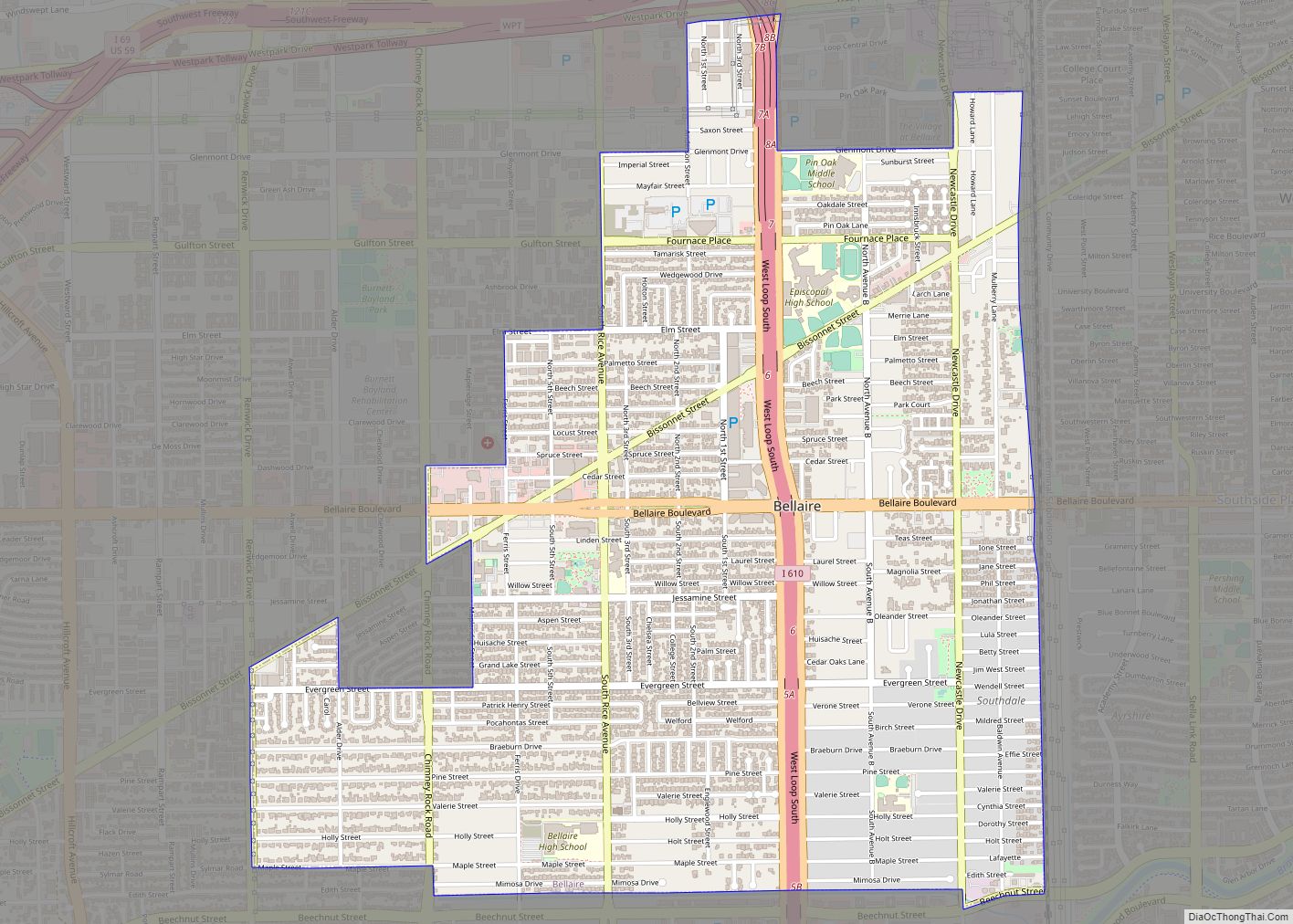
Bellaire Road Map
Bellaire city Satellite Map
Geography
Bellaire is located at 29°42′11″N 95°28′06″W / 29.70306°N 95.46833°W / 29.70306; -95.46833. According to the United States Census Bureau, the city has a total area of 3.6 sq mi (9.3 km), all of it land. The city is surrounded by Houston, West University Place, and Southside Place.
Cityscape
Bellaire’s housing lots are 75 feet (23 m) by 130 feet (40 m), allowing for houses larger than those that could be built on typical 50 feet (15 m) by 120 feet (37 m) West University Place lots. A Bellaire lot can accommodate a house with a detached garage and a swimming pool, while the typical West University Place lot could accommodate a newly constructed Georgian house described by Don Stowers of the Houston Post as “lot-hugging”. The more spacious and inexpensive housing lots prompted area home seekers to consider Bellaire.
The original Bellaire housing stock typically consisted of tree-bedroom, one-bathroom, post-World War II houses described by Stowers as “smallish”. Because of the attributes, developers did not hesitate to tear these houses down and build new houses. Some individuals chose to renovate their houses instead of having them torn down. Many individuals who would otherwise renovate the houses reconsidered their decisions as the land value increased. In some cases, the land value was higher than the value of the structure on the lot. Some subdivisions had larger houses, particularly the Carroll subdivision south of Bellaire Boulevard and the Braeburn Country Club Estates subdivision between Chimney Rock and Rice. Many of the houses in those subdivisions were built in the 1950s and early 1960s, and many were on .5 acres (0.20 ha) lots. Karl Lewis, the vice president and sales manager of John Daugherty Realtors, said that many of the houses were “still quite attractive” and “similar to the large Tanglewood homes.” In 1992 smaller lots in Bellaire were about $50,000 ($93,953.05 in 2021) and up, while larger lots were $300,000 ($563,718.28 in 2021) to $500,000 ($939,530.47 in 2021).
In a 2007 Houston Press article John Nova Lomax, a journalist, said that parts of Bellaire’s downtown had “a certain raffish 1950s charm – the Bellaire Broiler Burger, for example – but it’s boring.” Lomax stated in a 2008 Houston Press article that, due to the growth and dominance of Houston, municipal enclaves with their own services, including Bellaire, “are little more than glorified neighborhoods.”
Many Bellaire streets, such as “Holly,” “Holt,” “Maple,” and “Pine,” are named after trees. The word “Holt” means a small grove or a forest of trees.
One community in Bellaire, Southdale, was developed by William G. Farmington, the developer of Tanglewood. Southdale was originally developed in the late 1940s with two-bedroom houses. The houses were marketed to World War II veterans. The houses were about a fourth as expensive, around $25,000-each ($274,376.73 in 2021 dollars) as Tanglewood houses. Another subdivision in Bellaire is named “Broad Acres.”
See also
Map of Texas State and its subdivision:- Anderson
- Andrews
- Angelina
- Aransas
- Archer
- Armstrong
- Atascosa
- Austin
- Bailey
- Bandera
- Bastrop
- Baylor
- Bee
- Bell
- Bexar
- Blanco
- Borden
- Bosque
- Bowie
- Brazoria
- Brazos
- Brewster
- Briscoe
- Brooks
- Brown
- Burleson
- Burnet
- Caldwell
- Calhoun
- Callahan
- Cameron
- Camp
- Carson
- Cass
- Castro
- Chambers
- Cherokee
- Childress
- Clay
- Cochran
- Coke
- Coleman
- Collin
- Collingsworth
- Colorado
- Comal
- Comanche
- Concho
- Cooke
- Coryell
- Cottle
- Crane
- Crockett
- Crosby
- Culberson
- Dallam
- Dallas
- Dawson
- Deaf Smith
- Delta
- Denton
- Dewitt
- Dickens
- Dimmit
- Donley
- Duval
- Eastland
- Ector
- Edwards
- El Paso
- Ellis
- Erath
- Falls
- Fannin
- Fayette
- Fisher
- Floyd
- Foard
- Fort Bend
- Franklin
- Freestone
- Frio
- Gaines
- Galveston
- Garza
- Gillespie
- Glasscock
- Goliad
- Gonzales
- Gray
- Grayson
- Gregg
- Grimes
- Guadalupe
- Hale
- Hall
- Hamilton
- Hansford
- Hardeman
- Hardin
- Harris
- Harrison
- Hartley
- Haskell
- Hays
- Hemphill
- Henderson
- Hidalgo
- Hill
- Hockley
- Hood
- Hopkins
- Houston
- Howard
- Hudspeth
- Hunt
- Hutchinson
- Irion
- Jack
- Jackson
- Jasper
- Jeff Davis
- Jefferson
- Jim Hogg
- Jim Wells
- Johnson
- Jones
- Karnes
- Kaufman
- Kendall
- Kenedy
- Kent
- Kerr
- Kimble
- King
- Kinney
- Kleberg
- Knox
- La Salle
- Lamar
- Lamb
- Lampasas
- Lavaca
- Lee
- Leon
- Liberty
- Limestone
- Lipscomb
- Live Oak
- Llano
- Loving
- Lubbock
- Lynn
- Madison
- Marion
- Martin
- Mason
- Matagorda
- Maverick
- McCulloch
- McLennan
- McMullen
- Medina
- Menard
- Midland
- Milam
- Mills
- Mitchell
- Montague
- Montgomery
- Moore
- Morris
- Motley
- Nacogdoches
- Navarro
- Newton
- Nolan
- Nueces
- Ochiltree
- Oldham
- Orange
- Palo Pinto
- Panola
- Parker
- Parmer
- Pecos
- Polk
- Potter
- Presidio
- Rains
- Randall
- Reagan
- Real
- Red River
- Reeves
- Refugio
- Roberts
- Robertson
- Rockwall
- Runnels
- Rusk
- Sabine
- San Augustine
- San Jacinto
- San Patricio
- San Saba
- Schleicher
- Scurry
- Shackelford
- Shelby
- Sherman
- Smith
- Somervell
- Starr
- Stephens
- Sterling
- Stonewall
- Sutton
- Swisher
- Tarrant
- Taylor
- Terrell
- Terry
- Throckmorton
- Titus
- Tom Green
- Travis
- Trinity
- Tyler
- Upshur
- Upton
- Uvalde
- Val Verde
- Van Zandt
- Victoria
- Walker
- Waller
- Ward
- Washington
- Webb
- Wharton
- Wheeler
- Wichita
- Wilbarger
- Willacy
- Williamson
- Wilson
- Winkler
- Wise
- Wood
- Yoakum
- Young
- Zapata
- Zavala
- Alabama
- Alaska
- Arizona
- Arkansas
- California
- Colorado
- Connecticut
- Delaware
- District of Columbia
- Florida
- Georgia
- Hawaii
- Idaho
- Illinois
- Indiana
- Iowa
- Kansas
- Kentucky
- Louisiana
- Maine
- Maryland
- Massachusetts
- Michigan
- Minnesota
- Mississippi
- Missouri
- Montana
- Nebraska
- Nevada
- New Hampshire
- New Jersey
- New Mexico
- New York
- North Carolina
- North Dakota
- Ohio
- Oklahoma
- Oregon
- Pennsylvania
- Rhode Island
- South Carolina
- South Dakota
- Tennessee
- Texas
- Utah
- Vermont
- Virginia
- Washington
- West Virginia
- Wisconsin
- Wyoming
