Cibolo is a city in Guadalupe County, Texas, United States. It is part of the San Antonio–New Braunfels metropolitan statistical area. Cibolo voted to become an independent township on October 9, 1965. As of the 2020 census, Cibolo had a population of 32,276, up from 15,349 at the 2010 census.
| Name: | Cibolo city |
|---|---|
| LSAD Code: | 25 |
| LSAD Description: | city (suffix) |
| State: | Texas |
| County: | Bexar County, Guadalupe County |
| Elevation: | 699 ft (213 m) |
| Total Area: | 20.94 sq mi (54.23 km²) |
| Land Area: | 20.91 sq mi (54.16 km²) |
| Water Area: | 0.03 sq mi (0.07 km²) |
| Total Population: | 32,276 |
| Population Density: | 1,495.91/sq mi (577.58/km²) |
| ZIP code: | 78108 |
| Area code: | 210, 726 |
| FIPS code: | 4814920 |
| GNISfeature ID: | 1332832 |
| Website: | www.cibolotx.gov |
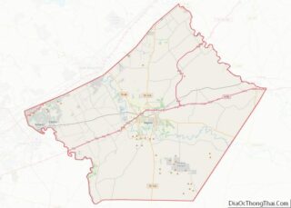
Online Interactive Map
Click on ![]() to view map in "full screen" mode.
to view map in "full screen" mode.
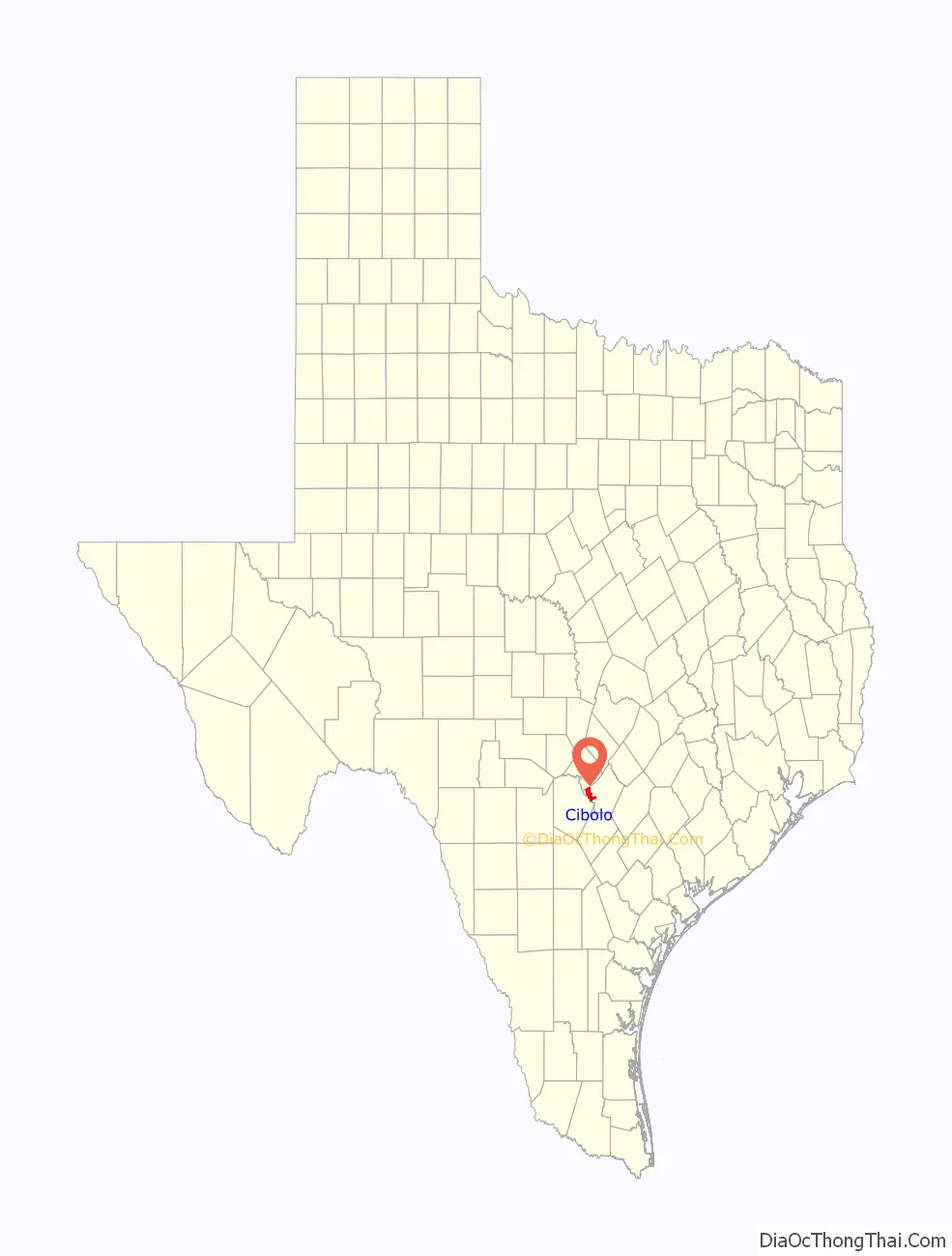
Cibolo location map. Where is Cibolo city?

History
Cibolo voted to become an independent township on October 9, 1965; the “City Fathers” were Mayor M.O. Grooms, Councilman Carl Biser, Councilman Ted Dykes, Councilman Alwin Lieck, Councilman Fred Niemietz, and Councilman D.O. Trotti.
Before the first European settlers arrived, the Comanche and several other Native American tribes lived in Cibolo. The name Cibolo means “buffalo”. The community first established when the Southern Pacific Railroad cut through the area en route to major cities such as Houston and San Antonio. Over time, Cibolo developed into the suburb it is today.
In 1867, George Schlather built a store on land purchased by his father Jacob. In 1882, the Schlathers sold the store to Charles Fromme, who renamed it Fromme’s Store. The community also became known by this name. In 1877, the Galveston, Harrisburg and San Antonio Railway station serving the area was called Cibolo Valley. In 1883, the US Post Office opened a branch in the town and called it Cibolo. By 1890, its population was 100 people.
Beginning in the 21st century, Cibolo has experienced high levels of growth, increasing 733% since 2000, when the population was 3,035 people. Between 2000 and 2010, the population increased 545% to 19,580 people. As Cibolo has grown, its share of the county population has also increased. In 2000, Cibolo accounted for only 3.4% of Guadalupe County’s population, but between 2000 and 2010, Cibolo captured 38.9% of the county’s growth, and its share of the population increased to 14.9%. Between 2010 and 2013, Cibolo acquired 22.3% of the growth in Guadalupe County, and today Cibolo accounts for 17% of the county’s population.
Cibolo Road Map

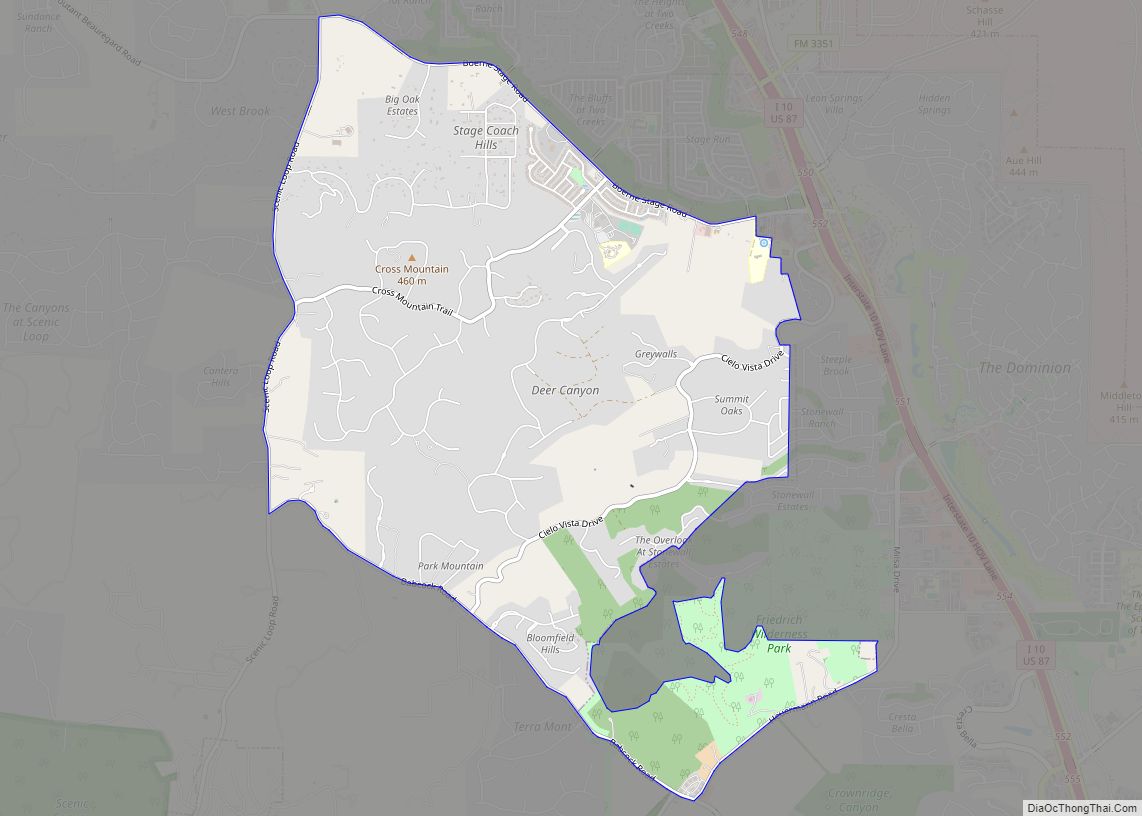
Cibolo city Satellite Map

Geography
Cibolo is in western Guadalupe County, on the north side of Cibolo Creek. A small portion of the city, south of West Schaefer Road, crosses a bend of Cibolo Creek to enter Bexar County. Santa Clara and Marion border Cibolo to the east. New Berlin, Zuehl, and St. Hedwig border Cibolo to the south. Schertz borders Cibolo to the north and west. The city of New Braunfels is 14 miles (23 km) to the northeast, and downtown San Antonio is 21 miles (34 km) to the southwest.
According to the U.S. Census Bureau, Cibolo has a total area of 6.6 square miles (17.0 km), of which 0.004 square miles (0.01 km), or 0.07%, is covered by water.
See also
Map of Texas State and its subdivision:- Anderson
- Andrews
- Angelina
- Aransas
- Archer
- Armstrong
- Atascosa
- Austin
- Bailey
- Bandera
- Bastrop
- Baylor
- Bee
- Bell
- Bexar
- Blanco
- Borden
- Bosque
- Bowie
- Brazoria
- Brazos
- Brewster
- Briscoe
- Brooks
- Brown
- Burleson
- Burnet
- Caldwell
- Calhoun
- Callahan
- Cameron
- Camp
- Carson
- Cass
- Castro
- Chambers
- Cherokee
- Childress
- Clay
- Cochran
- Coke
- Coleman
- Collin
- Collingsworth
- Colorado
- Comal
- Comanche
- Concho
- Cooke
- Coryell
- Cottle
- Crane
- Crockett
- Crosby
- Culberson
- Dallam
- Dallas
- Dawson
- Deaf Smith
- Delta
- Denton
- Dewitt
- Dickens
- Dimmit
- Donley
- Duval
- Eastland
- Ector
- Edwards
- El Paso
- Ellis
- Erath
- Falls
- Fannin
- Fayette
- Fisher
- Floyd
- Foard
- Fort Bend
- Franklin
- Freestone
- Frio
- Gaines
- Galveston
- Garza
- Gillespie
- Glasscock
- Goliad
- Gonzales
- Gray
- Grayson
- Gregg
- Grimes
- Guadalupe
- Hale
- Hall
- Hamilton
- Hansford
- Hardeman
- Hardin
- Harris
- Harrison
- Hartley
- Haskell
- Hays
- Hemphill
- Henderson
- Hidalgo
- Hill
- Hockley
- Hood
- Hopkins
- Houston
- Howard
- Hudspeth
- Hunt
- Hutchinson
- Irion
- Jack
- Jackson
- Jasper
- Jeff Davis
- Jefferson
- Jim Hogg
- Jim Wells
- Johnson
- Jones
- Karnes
- Kaufman
- Kendall
- Kenedy
- Kent
- Kerr
- Kimble
- King
- Kinney
- Kleberg
- Knox
- La Salle
- Lamar
- Lamb
- Lampasas
- Lavaca
- Lee
- Leon
- Liberty
- Limestone
- Lipscomb
- Live Oak
- Llano
- Loving
- Lubbock
- Lynn
- Madison
- Marion
- Martin
- Mason
- Matagorda
- Maverick
- McCulloch
- McLennan
- McMullen
- Medina
- Menard
- Midland
- Milam
- Mills
- Mitchell
- Montague
- Montgomery
- Moore
- Morris
- Motley
- Nacogdoches
- Navarro
- Newton
- Nolan
- Nueces
- Ochiltree
- Oldham
- Orange
- Palo Pinto
- Panola
- Parker
- Parmer
- Pecos
- Polk
- Potter
- Presidio
- Rains
- Randall
- Reagan
- Real
- Red River
- Reeves
- Refugio
- Roberts
- Robertson
- Rockwall
- Runnels
- Rusk
- Sabine
- San Augustine
- San Jacinto
- San Patricio
- San Saba
- Schleicher
- Scurry
- Shackelford
- Shelby
- Sherman
- Smith
- Somervell
- Starr
- Stephens
- Sterling
- Stonewall
- Sutton
- Swisher
- Tarrant
- Taylor
- Terrell
- Terry
- Throckmorton
- Titus
- Tom Green
- Travis
- Trinity
- Tyler
- Upshur
- Upton
- Uvalde
- Val Verde
- Van Zandt
- Victoria
- Walker
- Waller
- Ward
- Washington
- Webb
- Wharton
- Wheeler
- Wichita
- Wilbarger
- Willacy
- Williamson
- Wilson
- Winkler
- Wise
- Wood
- Yoakum
- Young
- Zapata
- Zavala
- Alabama
- Alaska
- Arizona
- Arkansas
- California
- Colorado
- Connecticut
- Delaware
- District of Columbia
- Florida
- Georgia
- Hawaii
- Idaho
- Illinois
- Indiana
- Iowa
- Kansas
- Kentucky
- Louisiana
- Maine
- Maryland
- Massachusetts
- Michigan
- Minnesota
- Mississippi
- Missouri
- Montana
- Nebraska
- Nevada
- New Hampshire
- New Jersey
- New Mexico
- New York
- North Carolina
- North Dakota
- Ohio
- Oklahoma
- Oregon
- Pennsylvania
- Rhode Island
- South Carolina
- South Dakota
- Tennessee
- Texas
- Utah
- Vermont
- Virginia
- Washington
- West Virginia
- Wisconsin
- Wyoming