Deer Park is a city in the U.S. state of Texas within the Houston–Sugar Land–Baytown metropolitan area. The city is located in Harris County and is situated in Southeast Harris County. At the 2020 U.S. census, the population of Deer Park was 34,495.
| Name: | Deer Park city |
|---|---|
| LSAD Code: | 25 |
| LSAD Description: | city (suffix) |
| State: | Texas |
| County: | Harris County |
| Incorporated: | 1948 |
| Elevation: | 26 ft (8 m) |
| Total Area: | 10.57 sq mi (27.37 km²) |
| Land Area: | 10.51 sq mi (27.21 km²) |
| Water Area: | 0.06 sq mi (0.16 km²) |
| Total Population: | 34,495 |
| Population Density: | 3,186.18/sq mi (1,230.23/km²) |
| ZIP code: | 77536 |
| FIPS code: | 4819624 |
| GNISfeature ID: | 1334219 |
| Website: | www.deerparktx.gov |
Online Interactive Map
Click on ![]() to view map in "full screen" mode.
to view map in "full screen" mode.
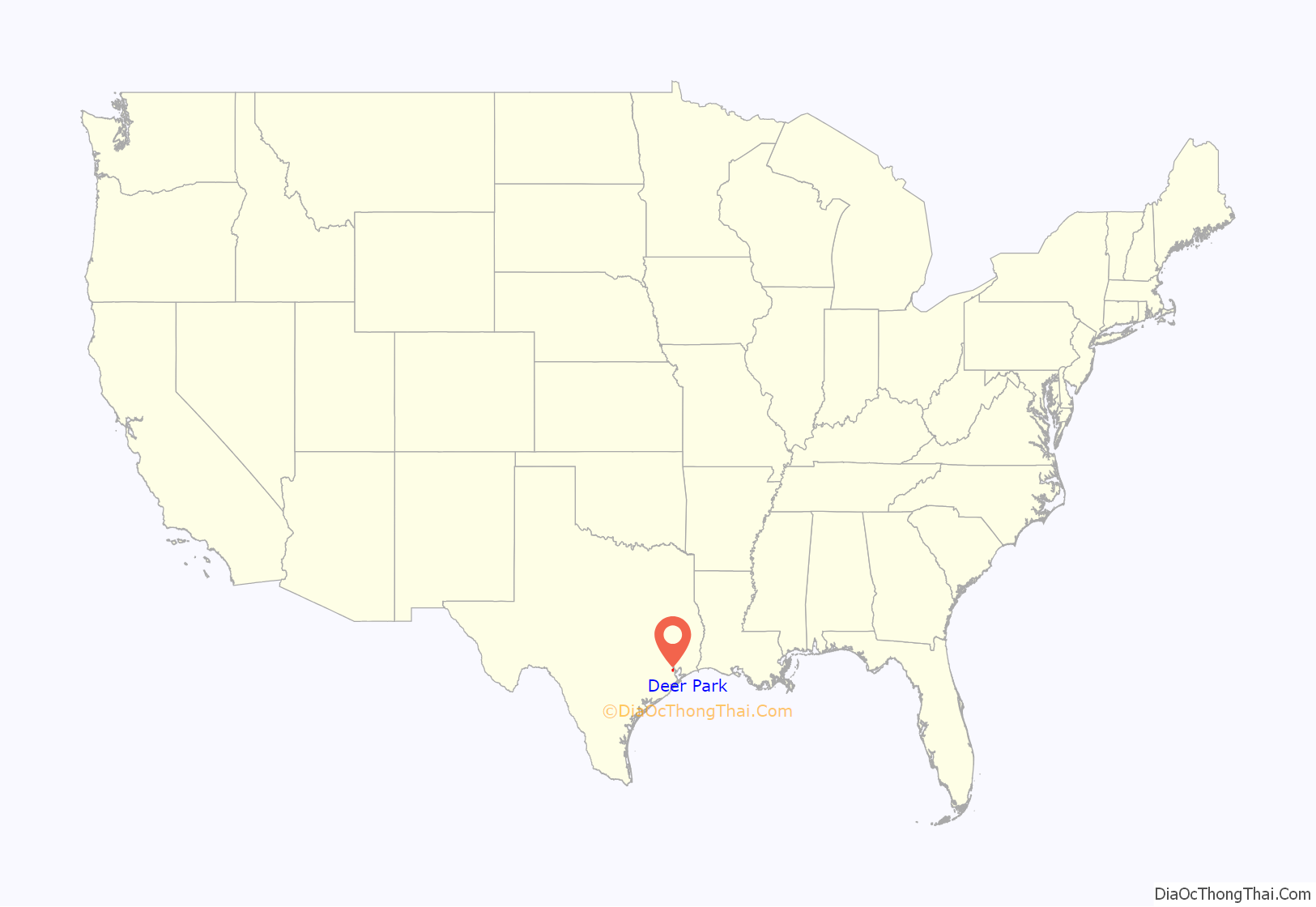
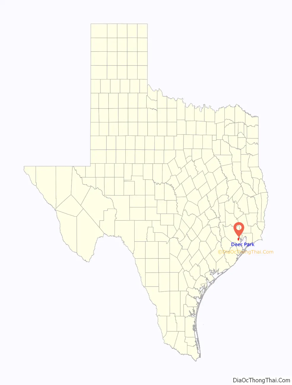
Deer Park location map. Where is Deer Park city?
History
Deer Park was founded in 1892 by Simeon H. West, a farmer, retired legislator, and much-traveled adventurer from Illinois. He named the town for the large number of deer that roamed the Gulf plains. A railroad station opened later that year and a post office followed in 1893.
The subdivision was established in 1893 and was the site of a Galveston, Harrisburg and San Antonio Railway station by about 1894. A Deer Park post office was established in 1893, discontinued in 1919, and reestablished in 1930. In 1896, the community, with a population of forty, had a hotel, a general store, and three resident carpenters. By 1922, Deer Park had dwindled down to almost nothing with four houses, one little schoolhouse, and an old hotel with a few scattered shacks along the railroad right-of-way. In 1928, Shell Oil Company broke ground on a new refinery. In the 1930s, an independent school district was established. By 1940, the population had grown to 100. By 1946, however, the area began to flourish as Deer Park became the site of refineries and toluene plants for the production of TNT.
The citizens of Deer Park voted to incorporate on December 12, 1948, and a few weeks later Earl E. Dunn became the first mayor. Because of the 1948 incorporation, Houston did not incorporate Deer Park’s territory into its city limits. The first city council meeting was held on February 7, 1949. The population had grown to 700 by 1948, to 5,000 by 1960 with a fire station, city hall, playground parks and an independent city water supply. A public library was begun in 1962. Population was 12,773 in 1970, and 28,520 in 2000. This growth has been fueled by the growth of the petrochemical industry as well as the growth of business along the Houston Ship Channel. Deer Park has a school district with 14 campuses, a city library, community theater, municipal court building, three fire stations, numerous city parks and recreational facilities, state-of-the-art water and sewer processing facilities, a post office, several hotels, 14 major industries as well as several light industrial companies. Today, Deer Park has approximately 9,000 homes and more than 30,000 residents.
Deer Park is near the site of the Battle of San Jacinto, where, on April 21, 1836, Texas won its independence from Mexico. Because the initial surrender treaty after the battle was drafted in Dr. George Moffitt Patrick’s cabin, Deer Park bills itself as the “Birthplace of Texas”. The original cabin was located on Buffalo Bayou where Rohm and Haas, now owned by Dow Chemical Company, established a chemical plant in Deer Park. A replica of Dr. Patrick’s cabin is in front of the Theatre/Courts Building on Center Street. The Texas State Historical sign marker was relocated from the Dow Chemical parking lot to the replica log cabin home of Dr. Patrick located at the Theatre/Courts Building.
Shell Chemical plant explosion
On June 22, 1997, an ethylene explosion occurred at the nearby Shell Chemical Company plant that was heard and felt as far as 25 miles (40 km) away. While no evacuation of the city was ordered, residents living within a mile west of the plant were advised to remain inside their homes.
Intercontinental Terminals Company’s chemical fire
On March 17, 2019, a huge chemical fire broke out in the chemical tank farm at Intercontinental Terminals Company. The fire, which was caused by a leak in one tank, eventually spread to a dozen tanks. The leak was caused by a failure of manifold power frame of the tank. The resultant fire and smoke flume could be seen for miles and lasted for three days. The tanks involved in the fire contained chemicals including xylene, naptha, pyrolysis gasoline (Pygas), and toluene. Deer Park residents were required to shelter in place during the fire.
January 24, 2023 tornado
Deer Park has been known for several smaller and less destructive tornadoes in its past, but on January 24, 2023, a large EF3 tornado hit downtown Deer Park. It caused damage most notably to a nursing home and an animal shelter, brought down cell service for the city, and knocked out power to many areas, including schools in the Deer Park Independent School District. Schools were still in session at the time of the tornado, but no students or teachers in the affected schools were injured or killed. Entire neighborhoods were severely damaged as a result of the tornado. The tornado prompted the first ever tornado emergency issued by the National Weather Service in League City.
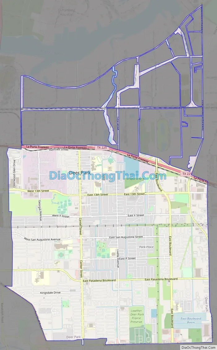
Deer Park Road Map
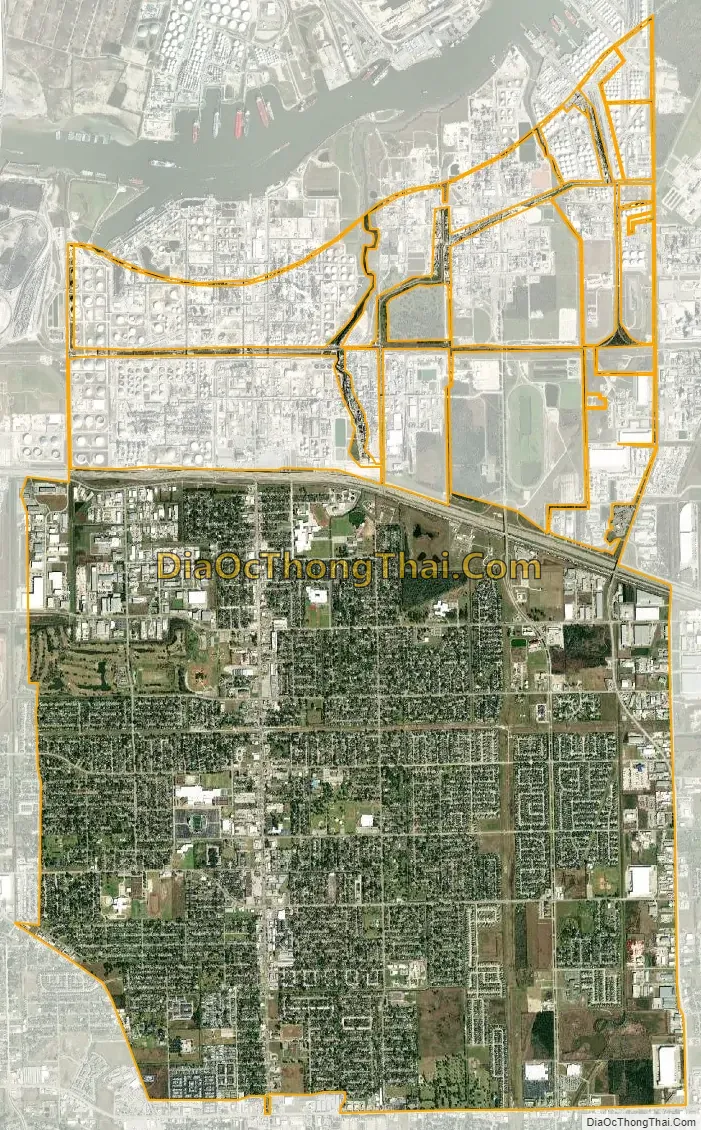
Deer Park city Satellite Map
Geography
Deer Park is located in Southeastern Harris County at 29°41′31″N 95°7′5″W / 29.69194°N 95.11806°W / 29.69194; -95.11806 (29.692003, –95.118108). According to the United States Census Bureau, the city has a total area of 10.52 square miles (27.25 km), of which 10.46 square miles (27.08 km) are land and 0.07 square miles (0.17 km), or 0.62%, are water.
Deer Park is bounded by the city of La Porte to the south and east, and by the Houston Ship Channel—the dredged-out Buffalo Bayou—to the north.
See also
Map of Texas State and its subdivision:- Anderson
- Andrews
- Angelina
- Aransas
- Archer
- Armstrong
- Atascosa
- Austin
- Bailey
- Bandera
- Bastrop
- Baylor
- Bee
- Bell
- Bexar
- Blanco
- Borden
- Bosque
- Bowie
- Brazoria
- Brazos
- Brewster
- Briscoe
- Brooks
- Brown
- Burleson
- Burnet
- Caldwell
- Calhoun
- Callahan
- Cameron
- Camp
- Carson
- Cass
- Castro
- Chambers
- Cherokee
- Childress
- Clay
- Cochran
- Coke
- Coleman
- Collin
- Collingsworth
- Colorado
- Comal
- Comanche
- Concho
- Cooke
- Coryell
- Cottle
- Crane
- Crockett
- Crosby
- Culberson
- Dallam
- Dallas
- Dawson
- Deaf Smith
- Delta
- Denton
- Dewitt
- Dickens
- Dimmit
- Donley
- Duval
- Eastland
- Ector
- Edwards
- El Paso
- Ellis
- Erath
- Falls
- Fannin
- Fayette
- Fisher
- Floyd
- Foard
- Fort Bend
- Franklin
- Freestone
- Frio
- Gaines
- Galveston
- Garza
- Gillespie
- Glasscock
- Goliad
- Gonzales
- Gray
- Grayson
- Gregg
- Grimes
- Guadalupe
- Hale
- Hall
- Hamilton
- Hansford
- Hardeman
- Hardin
- Harris
- Harrison
- Hartley
- Haskell
- Hays
- Hemphill
- Henderson
- Hidalgo
- Hill
- Hockley
- Hood
- Hopkins
- Houston
- Howard
- Hudspeth
- Hunt
- Hutchinson
- Irion
- Jack
- Jackson
- Jasper
- Jeff Davis
- Jefferson
- Jim Hogg
- Jim Wells
- Johnson
- Jones
- Karnes
- Kaufman
- Kendall
- Kenedy
- Kent
- Kerr
- Kimble
- King
- Kinney
- Kleberg
- Knox
- La Salle
- Lamar
- Lamb
- Lampasas
- Lavaca
- Lee
- Leon
- Liberty
- Limestone
- Lipscomb
- Live Oak
- Llano
- Loving
- Lubbock
- Lynn
- Madison
- Marion
- Martin
- Mason
- Matagorda
- Maverick
- McCulloch
- McLennan
- McMullen
- Medina
- Menard
- Midland
- Milam
- Mills
- Mitchell
- Montague
- Montgomery
- Moore
- Morris
- Motley
- Nacogdoches
- Navarro
- Newton
- Nolan
- Nueces
- Ochiltree
- Oldham
- Orange
- Palo Pinto
- Panola
- Parker
- Parmer
- Pecos
- Polk
- Potter
- Presidio
- Rains
- Randall
- Reagan
- Real
- Red River
- Reeves
- Refugio
- Roberts
- Robertson
- Rockwall
- Runnels
- Rusk
- Sabine
- San Augustine
- San Jacinto
- San Patricio
- San Saba
- Schleicher
- Scurry
- Shackelford
- Shelby
- Sherman
- Smith
- Somervell
- Starr
- Stephens
- Sterling
- Stonewall
- Sutton
- Swisher
- Tarrant
- Taylor
- Terrell
- Terry
- Throckmorton
- Titus
- Tom Green
- Travis
- Trinity
- Tyler
- Upshur
- Upton
- Uvalde
- Val Verde
- Van Zandt
- Victoria
- Walker
- Waller
- Ward
- Washington
- Webb
- Wharton
- Wheeler
- Wichita
- Wilbarger
- Willacy
- Williamson
- Wilson
- Winkler
- Wise
- Wood
- Yoakum
- Young
- Zapata
- Zavala
- Alabama
- Alaska
- Arizona
- Arkansas
- California
- Colorado
- Connecticut
- Delaware
- District of Columbia
- Florida
- Georgia
- Hawaii
- Idaho
- Illinois
- Indiana
- Iowa
- Kansas
- Kentucky
- Louisiana
- Maine
- Maryland
- Massachusetts
- Michigan
- Minnesota
- Mississippi
- Missouri
- Montana
- Nebraska
- Nevada
- New Hampshire
- New Jersey
- New Mexico
- New York
- North Carolina
- North Dakota
- Ohio
- Oklahoma
- Oregon
- Pennsylvania
- Rhode Island
- South Carolina
- South Dakota
- Tennessee
- Texas
- Utah
- Vermont
- Virginia
- Washington
- West Virginia
- Wisconsin
- Wyoming


