Hunters Creek Village is a city in Harris County, Texas, United States, part of the Greater Houston metropolitan area. The population was 4,385 at the 2020 census. It is part of a collection of upscale residential communities in west Houston known as the Memorial Villages.
As of 2000, Hunters Creek Village was the 5th wealthiest location in Texas by per capita income. A 2010 BusinessWeek study stated that Hunters Creek Village was the most expensive suburb in Texas.
| Name: | Hunters Creek Village city |
|---|---|
| LSAD Code: | 25 |
| LSAD Description: | city (suffix) |
| State: | Texas |
| County: | Harris County |
| Elevation: | 66 ft (20 m) |
| Total Area: | 1.95 sq mi (5.06 km²) |
| Land Area: | 1.95 sq mi (5.06 km²) |
| Water Area: | 0.00 sq mi (0.00 km²) |
| Total Population: | 4,385 |
| Population Density: | 2,491.81/sq mi (962.25/km²) |
| ZIP code: | 77024 |
| Area code: | 713 |
| FIPS code: | 4835480 |
| GNISfeature ID: | 1374180 |
| Website: | www.cityofhunterscreek.com |
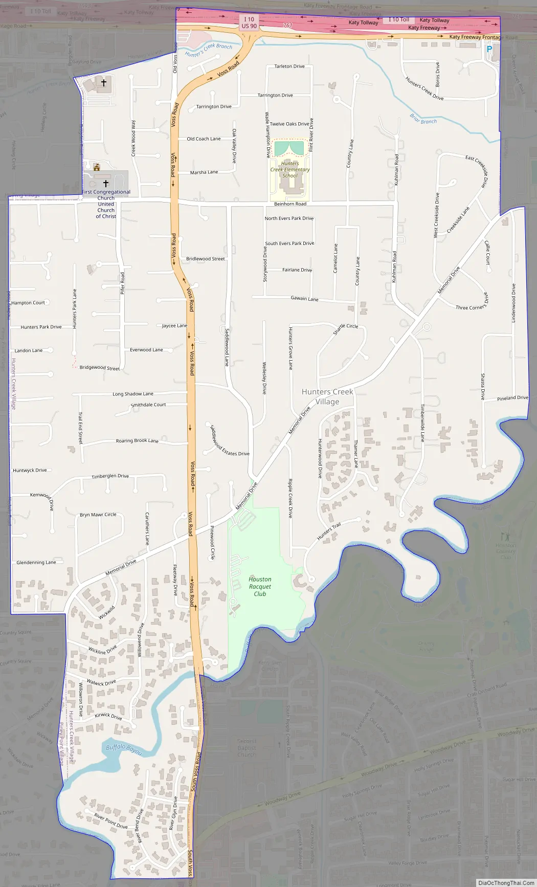
Online Interactive Map
Click on ![]() to view map in "full screen" mode.
to view map in "full screen" mode.
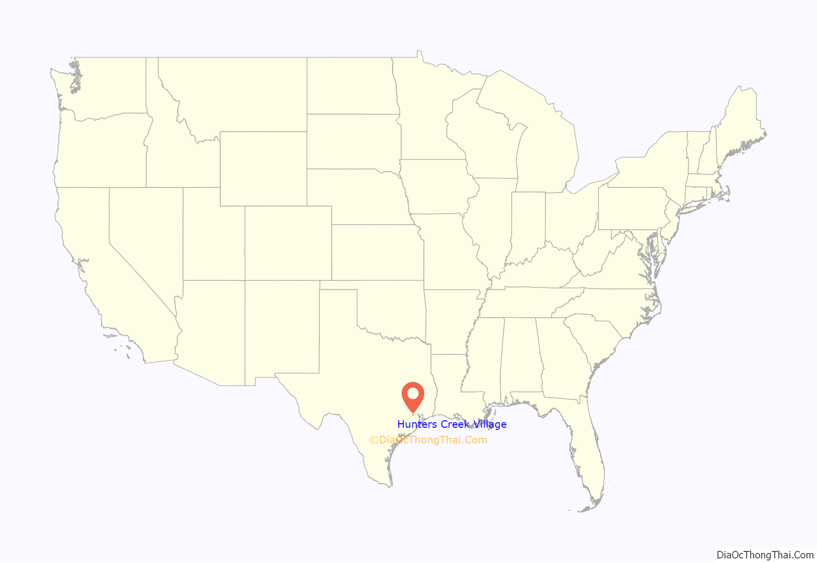
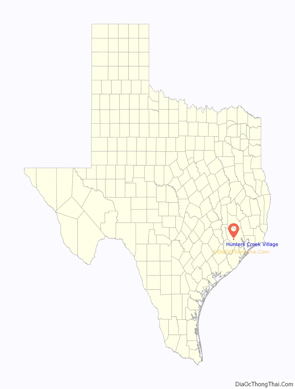
Hunters Creek Village location map. Where is Hunters Creek Village city?
History
Prior to the incorporation of Hunters Creek Village, German and a family of immigrant French-Canadian farmers settled the area and opened sawmills. By 1936 the community had a sawmill, several residences, and a traditional French-Canadian eatery that remains to this day.
In the mid-1950s, effort to form a Spring Branch municipality failed. The city incorporated in 1954 with a mayor-alderman government. Because of the 1954 incorporation, Houston did not incorporate Hunters Creek Village’s territory into its city limits, while Houston annexed surrounding areas that were unincorporated. By 1966 year the community had a school and a church. Between 1960 and 1980 the population increased from 2,478 to 4,580. In 1982 the population fell to 4,215. 4,598 people lived in Hunters Creek Village in 1990.
In 2008, Forbes.com selected Hunters Creek Village, along with the adjacent community of Bunker Hill Village and (southwest suburban) Sugar Land, as one of the three Houston-area “Top Suburbs To Live Well.”
Hunters Creek Village Road Map
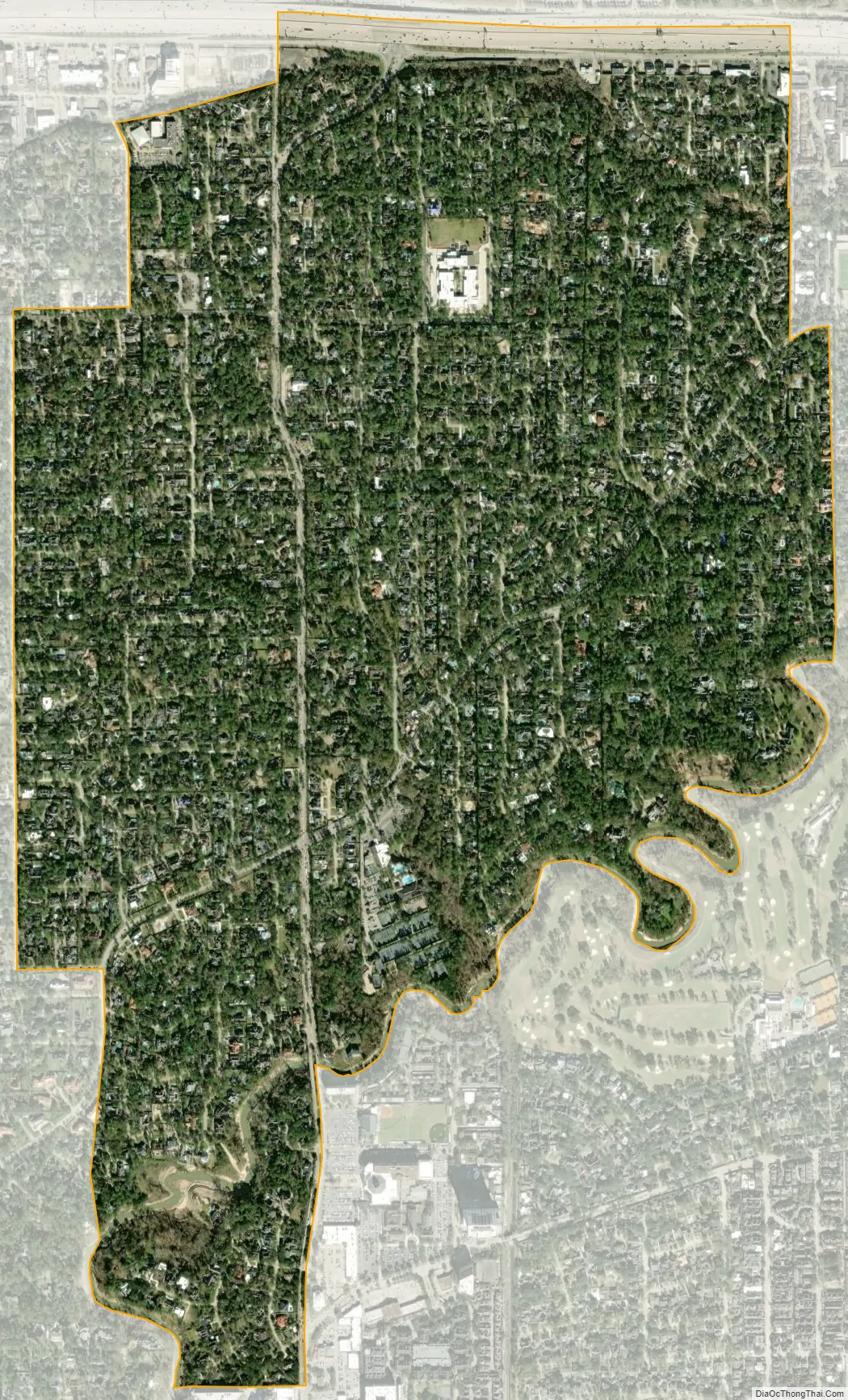
Hunters Creek Village city Satellite Map
Geography
Hunters Creek Village is located at 29°46′11″N 95°30′1″W / 29.76972°N 95.50028°W / 29.76972; -95.50028 (29.769632, –95.500190).
According to the United States Census Bureau, the city has a total area of 1.9 square miles (4.9 km), all of it land.
See also
Map of Texas State and its subdivision:- Anderson
- Andrews
- Angelina
- Aransas
- Archer
- Armstrong
- Atascosa
- Austin
- Bailey
- Bandera
- Bastrop
- Baylor
- Bee
- Bell
- Bexar
- Blanco
- Borden
- Bosque
- Bowie
- Brazoria
- Brazos
- Brewster
- Briscoe
- Brooks
- Brown
- Burleson
- Burnet
- Caldwell
- Calhoun
- Callahan
- Cameron
- Camp
- Carson
- Cass
- Castro
- Chambers
- Cherokee
- Childress
- Clay
- Cochran
- Coke
- Coleman
- Collin
- Collingsworth
- Colorado
- Comal
- Comanche
- Concho
- Cooke
- Coryell
- Cottle
- Crane
- Crockett
- Crosby
- Culberson
- Dallam
- Dallas
- Dawson
- Deaf Smith
- Delta
- Denton
- Dewitt
- Dickens
- Dimmit
- Donley
- Duval
- Eastland
- Ector
- Edwards
- El Paso
- Ellis
- Erath
- Falls
- Fannin
- Fayette
- Fisher
- Floyd
- Foard
- Fort Bend
- Franklin
- Freestone
- Frio
- Gaines
- Galveston
- Garza
- Gillespie
- Glasscock
- Goliad
- Gonzales
- Gray
- Grayson
- Gregg
- Grimes
- Guadalupe
- Hale
- Hall
- Hamilton
- Hansford
- Hardeman
- Hardin
- Harris
- Harrison
- Hartley
- Haskell
- Hays
- Hemphill
- Henderson
- Hidalgo
- Hill
- Hockley
- Hood
- Hopkins
- Houston
- Howard
- Hudspeth
- Hunt
- Hutchinson
- Irion
- Jack
- Jackson
- Jasper
- Jeff Davis
- Jefferson
- Jim Hogg
- Jim Wells
- Johnson
- Jones
- Karnes
- Kaufman
- Kendall
- Kenedy
- Kent
- Kerr
- Kimble
- King
- Kinney
- Kleberg
- Knox
- La Salle
- Lamar
- Lamb
- Lampasas
- Lavaca
- Lee
- Leon
- Liberty
- Limestone
- Lipscomb
- Live Oak
- Llano
- Loving
- Lubbock
- Lynn
- Madison
- Marion
- Martin
- Mason
- Matagorda
- Maverick
- McCulloch
- McLennan
- McMullen
- Medina
- Menard
- Midland
- Milam
- Mills
- Mitchell
- Montague
- Montgomery
- Moore
- Morris
- Motley
- Nacogdoches
- Navarro
- Newton
- Nolan
- Nueces
- Ochiltree
- Oldham
- Orange
- Palo Pinto
- Panola
- Parker
- Parmer
- Pecos
- Polk
- Potter
- Presidio
- Rains
- Randall
- Reagan
- Real
- Red River
- Reeves
- Refugio
- Roberts
- Robertson
- Rockwall
- Runnels
- Rusk
- Sabine
- San Augustine
- San Jacinto
- San Patricio
- San Saba
- Schleicher
- Scurry
- Shackelford
- Shelby
- Sherman
- Smith
- Somervell
- Starr
- Stephens
- Sterling
- Stonewall
- Sutton
- Swisher
- Tarrant
- Taylor
- Terrell
- Terry
- Throckmorton
- Titus
- Tom Green
- Travis
- Trinity
- Tyler
- Upshur
- Upton
- Uvalde
- Val Verde
- Van Zandt
- Victoria
- Walker
- Waller
- Ward
- Washington
- Webb
- Wharton
- Wheeler
- Wichita
- Wilbarger
- Willacy
- Williamson
- Wilson
- Winkler
- Wise
- Wood
- Yoakum
- Young
- Zapata
- Zavala
- Alabama
- Alaska
- Arizona
- Arkansas
- California
- Colorado
- Connecticut
- Delaware
- District of Columbia
- Florida
- Georgia
- Hawaii
- Idaho
- Illinois
- Indiana
- Iowa
- Kansas
- Kentucky
- Louisiana
- Maine
- Maryland
- Massachusetts
- Michigan
- Minnesota
- Mississippi
- Missouri
- Montana
- Nebraska
- Nevada
- New Hampshire
- New Jersey
- New Mexico
- New York
- North Carolina
- North Dakota
- Ohio
- Oklahoma
- Oregon
- Pennsylvania
- Rhode Island
- South Carolina
- South Dakota
- Tennessee
- Texas
- Utah
- Vermont
- Virginia
- Washington
- West Virginia
- Wisconsin
- Wyoming


