Bryan is a city and the seat of government of Brazos County, Texas, United States. It is located in the heart of the Brazos Valley (East and Central Texas). As of the 2020 census, the city had a population of 83,980. Bryan borders the city of College Station, which lies to its south. Together they are referred to as the Bryan–College Station metropolitan area, which has a population of more than 250,069.
| Name: | Bryan city |
|---|---|
| LSAD Code: | 25 |
| LSAD Description: | city (suffix) |
| State: | Texas |
| County: | Brazos County |
| Incorporated: | 1871 |
| Elevation: | 361 ft (110 m) |
| Total Area: | 54.26 sq mi (140.53 km²) |
| Land Area: | 54.16 sq mi (140.28 km²) |
| Water Area: | 0.10 sq mi (0.25 km²) |
| Total Population: | 83,980 |
| Population Density: | 1,592.87/sq mi (615.01/km²) |
| ZIP code: | 77801-03, 77807-08 |
| Area code: | 979 |
| FIPS code: | 4810912 |
| GNISfeature ID: | 2409927 |
| Website: | www.bryantx.gov |
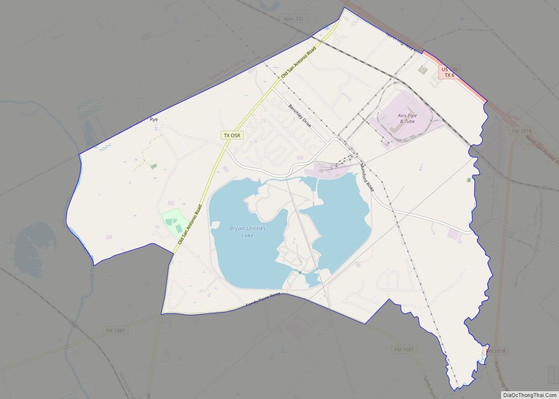
Online Interactive Map
Click on ![]() to view map in "full screen" mode.
to view map in "full screen" mode.
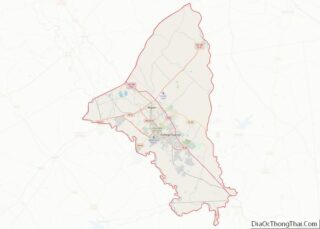
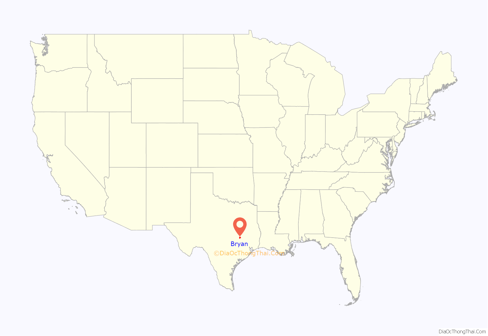
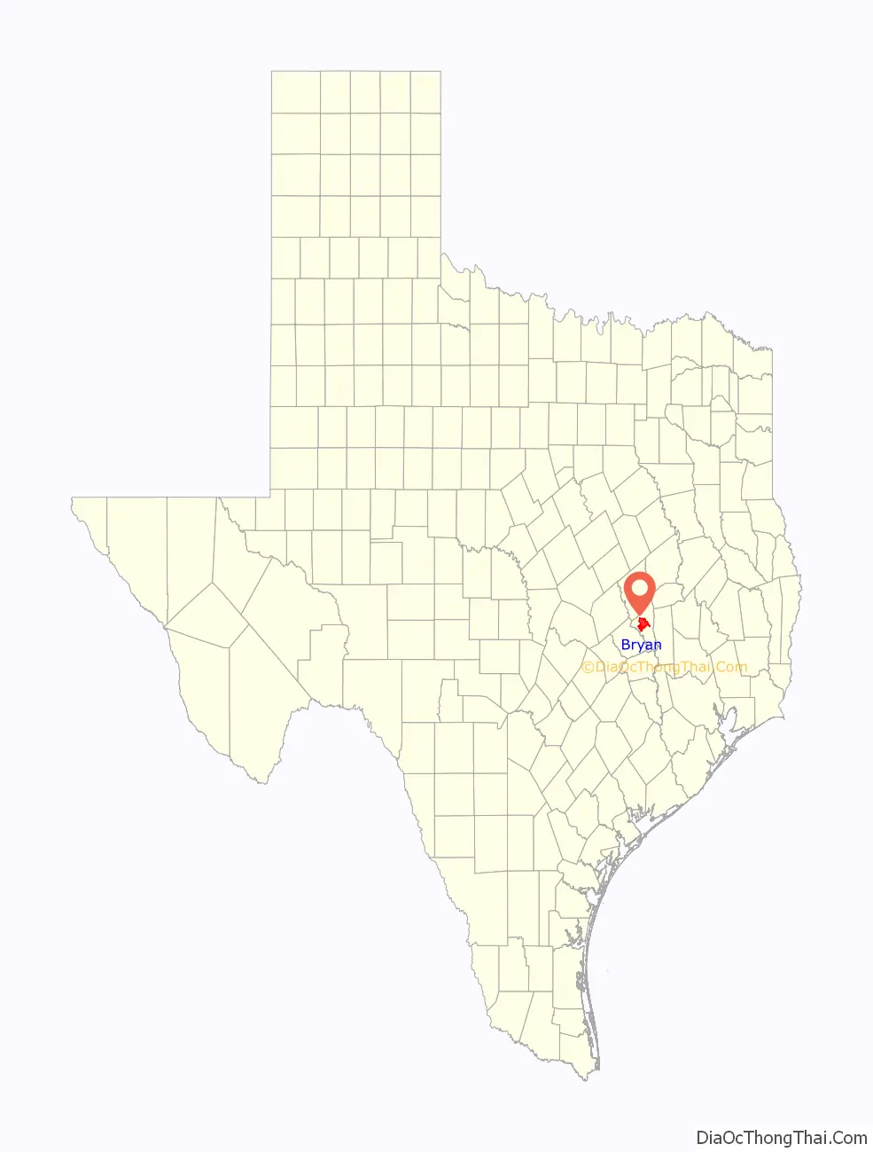
Bryan location map. Where is Bryan city?
History
The area around Bryan was part of a land grant to Moses Austin by Spain. Austin’s son, Stephen F. Austin, helped bring settlers to the area. Among the settlers was William Joel Bryan, the nephew of Stephen Austin. In 1866 the county seat of Brazos County was changed from Boonville to Bryan, and a post office was opened. In 1867, after many delays caused by the Civil War, the Houston and Texas Central Railroad, which had only previously gotten as far as Millican, finally reached Bryan. A short time later, in 1871, the city of Bryan became incorporated. Just south of Bryan, Texas A&M College opened in 1876 in what later would be known as College Station. The following year, 1877 saw the establishment of the Bryan Independent School District. Keeping up with progress in the rest of the country, Bryan added electric lighting and a waterworks to its community in 1889. The fifth Brazos County courthouse was built in 1892, and by the turn of the century, in 1900, the International-Great Northern Railroad stopped in Bryan.
Using a generous grant of $10,000 from Andrew Carnegie, the Carnegie Library of Bryan opened its doors in 1902. A bell, made in 1905 and rung in 1918 to signal the end of World War I is still located out front today. In 1910 the town built an interurban railroad to College Station. By 1923 the line was abandoned. The first Jewish place of worship, the Temple Freda synagogue, was opened in 1913. During the 1930s the town of North Oakwood merged with Bryan. Now Bryan and College Station are “twin” cities. In 1936 State Highway 6 was built, running right through town.
In 2006, the Texas A&M University System announced that the new Texas A&M Health Science Center campus would be built in Bryan near the new Traditions Golf Course development.
A fire at the El Dorado Chemical Co. in 2009 caused the evacuation of 70,000 residents due to the burning of ammonium nitrate, possibly causing minor respiratory problems. However, the city requested that only “anyone who can smell smoke or see smoke to evacuate their homes and businesses” and did not enforce an evacuation except for 500 homes in the nearby vicinity of the fire. Less than 1,000 residents chose to evacuate, taking shelter at Texas A&M University, which closed its campus for the day to ease traffic problems. City fire officials chose to let the fire burn down before tackling it, since the chemicals were water reactive. The evacuation, which started at 2:30 pm CST ended at 7 pm, except for a small, defined area immediately around the fire, where approximately 100 Bryan residents lived. In the end, only 500 residents were under a mandatory evacuation, and 35 people were treated for respiratory problems from the smoke. Officials from El Dorado said there was never any danger from the smoke or fire. The warehouse, valued at just under $1 million, was destroyed.
In 2010, the Brazos County District Attorney’s Office started the enforcement of a “Gang Safety Zone” in response to an escalation in violence within Bryan. Major US papers and ABC News covered this move. Cities like Houston and Los Angeles looked to the Bryan model of safety enforcement surrounding gang violence. The injunction declared a 3.2-mile (5.1 km) area in Bryan as the Gang Safety Zone. This placed about half of downtown in the area.
In 2013 the Planned Parenthood clinic in Bryan closed as a result of state budget cuts which impacted family-planning facilities. The facility began offering abortions in 1998; it was one of three in the state which ceased operations on August 31, 2013.
On April 8, 2021, a workplace shooting occurred in Bryan. An employee of Kent Moore Cabinets, a local cabinet-making company, killed one person and injured five others, four of them critically. He then fled but was later taken into police custody, shooting and injuring a state trooper in the process. In June, 27-year-old suspect Larry Bollin was indicted by a grand jury on charges of murder and aggravated assault.
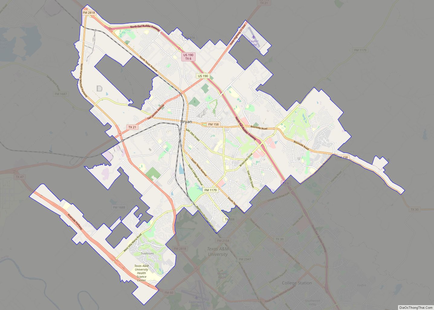
Bryan Road Map

Bryan city Satellite Map

Geography
Bryan is located northwest of the center of Brazos County. It is bordered to the southeast by the city of College Station and to the northwest by the unincorporated community of Lake Bryan. The Brazos River flows past approximately nine miles to the southwest. According to the United States Census Bureau, the city has a total area of 44.5 square miles (115.3 km), of which 44.4 square miles (115.0 km) is land and 0.077 square miles (0.2 km), or 0.20%, is water.
Climate
The local climate is subtropical and temperate, and winters are mild with periods of low temperatures usually lasting less than two months. Snow and ice are extremely rare. Summers are warm and hot with occasional showers being the only real variation in weather.
See also
Map of Texas State and its subdivision:- Anderson
- Andrews
- Angelina
- Aransas
- Archer
- Armstrong
- Atascosa
- Austin
- Bailey
- Bandera
- Bastrop
- Baylor
- Bee
- Bell
- Bexar
- Blanco
- Borden
- Bosque
- Bowie
- Brazoria
- Brazos
- Brewster
- Briscoe
- Brooks
- Brown
- Burleson
- Burnet
- Caldwell
- Calhoun
- Callahan
- Cameron
- Camp
- Carson
- Cass
- Castro
- Chambers
- Cherokee
- Childress
- Clay
- Cochran
- Coke
- Coleman
- Collin
- Collingsworth
- Colorado
- Comal
- Comanche
- Concho
- Cooke
- Coryell
- Cottle
- Crane
- Crockett
- Crosby
- Culberson
- Dallam
- Dallas
- Dawson
- Deaf Smith
- Delta
- Denton
- Dewitt
- Dickens
- Dimmit
- Donley
- Duval
- Eastland
- Ector
- Edwards
- El Paso
- Ellis
- Erath
- Falls
- Fannin
- Fayette
- Fisher
- Floyd
- Foard
- Fort Bend
- Franklin
- Freestone
- Frio
- Gaines
- Galveston
- Garza
- Gillespie
- Glasscock
- Goliad
- Gonzales
- Gray
- Grayson
- Gregg
- Grimes
- Guadalupe
- Hale
- Hall
- Hamilton
- Hansford
- Hardeman
- Hardin
- Harris
- Harrison
- Hartley
- Haskell
- Hays
- Hemphill
- Henderson
- Hidalgo
- Hill
- Hockley
- Hood
- Hopkins
- Houston
- Howard
- Hudspeth
- Hunt
- Hutchinson
- Irion
- Jack
- Jackson
- Jasper
- Jeff Davis
- Jefferson
- Jim Hogg
- Jim Wells
- Johnson
- Jones
- Karnes
- Kaufman
- Kendall
- Kenedy
- Kent
- Kerr
- Kimble
- King
- Kinney
- Kleberg
- Knox
- La Salle
- Lamar
- Lamb
- Lampasas
- Lavaca
- Lee
- Leon
- Liberty
- Limestone
- Lipscomb
- Live Oak
- Llano
- Loving
- Lubbock
- Lynn
- Madison
- Marion
- Martin
- Mason
- Matagorda
- Maverick
- McCulloch
- McLennan
- McMullen
- Medina
- Menard
- Midland
- Milam
- Mills
- Mitchell
- Montague
- Montgomery
- Moore
- Morris
- Motley
- Nacogdoches
- Navarro
- Newton
- Nolan
- Nueces
- Ochiltree
- Oldham
- Orange
- Palo Pinto
- Panola
- Parker
- Parmer
- Pecos
- Polk
- Potter
- Presidio
- Rains
- Randall
- Reagan
- Real
- Red River
- Reeves
- Refugio
- Roberts
- Robertson
- Rockwall
- Runnels
- Rusk
- Sabine
- San Augustine
- San Jacinto
- San Patricio
- San Saba
- Schleicher
- Scurry
- Shackelford
- Shelby
- Sherman
- Smith
- Somervell
- Starr
- Stephens
- Sterling
- Stonewall
- Sutton
- Swisher
- Tarrant
- Taylor
- Terrell
- Terry
- Throckmorton
- Titus
- Tom Green
- Travis
- Trinity
- Tyler
- Upshur
- Upton
- Uvalde
- Val Verde
- Van Zandt
- Victoria
- Walker
- Waller
- Ward
- Washington
- Webb
- Wharton
- Wheeler
- Wichita
- Wilbarger
- Willacy
- Williamson
- Wilson
- Winkler
- Wise
- Wood
- Yoakum
- Young
- Zapata
- Zavala
- Alabama
- Alaska
- Arizona
- Arkansas
- California
- Colorado
- Connecticut
- Delaware
- District of Columbia
- Florida
- Georgia
- Hawaii
- Idaho
- Illinois
- Indiana
- Iowa
- Kansas
- Kentucky
- Louisiana
- Maine
- Maryland
- Massachusetts
- Michigan
- Minnesota
- Mississippi
- Missouri
- Montana
- Nebraska
- Nevada
- New Hampshire
- New Jersey
- New Mexico
- New York
- North Carolina
- North Dakota
- Ohio
- Oklahoma
- Oregon
- Pennsylvania
- Rhode Island
- South Carolina
- South Dakota
- Tennessee
- Texas
- Utah
- Vermont
- Virginia
- Washington
- West Virginia
- Wisconsin
- Wyoming