Cameron is a city in Milam County, Texas, United States. Its population was 5,306 at the 2020 census. It is the county seat of Milam County.
| Name: | Cameron city |
|---|---|
| LSAD Code: | 25 |
| LSAD Description: | city (suffix) |
| State: | Texas |
| County: | Milam County |
| Elevation: | 400 ft (100 m) |
| Total Area: | 5.24 sq mi (13.57 km²) |
| Land Area: | 5.24 sq mi (13.57 km²) |
| Water Area: | 0.00 sq mi (0.00 km²) |
| Total Population: | 5,306 |
| Population Density: | 1,042.95/sq mi (402.72/km²) |
| ZIP code: | 76520 |
| Area code: | 254 |
| FIPS code: | 4812040 |
| GNISfeature ID: | 1353598 |
| Website: | www.camerontexas.net |
Online Interactive Map
Click on ![]() to view map in "full screen" mode.
to view map in "full screen" mode.
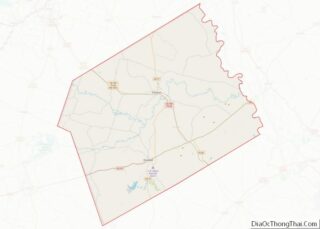
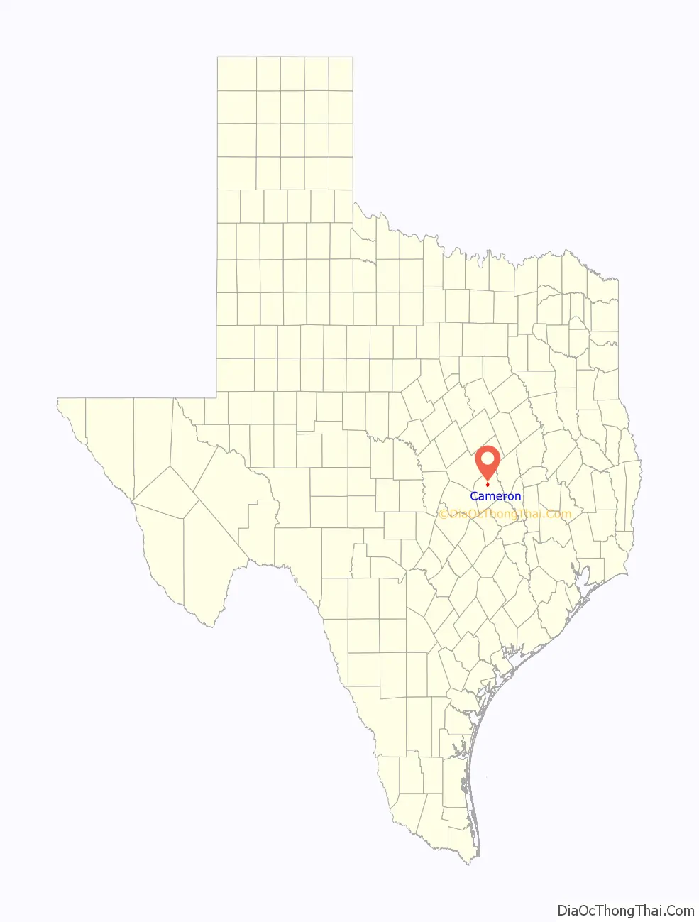
Cameron location map. Where is Cameron city?

History
Early years
Soon after Texas became a U.S. state, the Texas Legislature authorized a seven-member commission to find a permanent site for the Milam County seat. The commission purchased a 60-acre tract of Daniel Monroe’s headright on the Little River in 1846 and named the new community Cameron after Ewen Cameron, a Scottish highlander prominent in the Texas Revolution and a member of the Mier Expedition during the war with Mexico. When the courthouse in Cameron was completed later that year, county records were transferred to Cameron from Nashville—a community situated along the Brazos River that had served as the Milam County seat during the period when Texas was an independent republic. The new town struggled due to its isolated location, with the nearest railroad being 50 miles away. In the late 1840s and early 1850s, several attempts were made to navigate the Little River to give Cameron easier access to trade routes. The most successful attempts occurred in 1850 after heavy rains made the river rise. J.W. McCown Sr. persuaded Captain Basil M. Hatfield to bring his steamboat Washington through the upper Brazos up to the Little River. The steamboat and the merchandise it brought caused great excitement among the locals, and a two-day celebration was held when the boat tied up 2.5 miles east of Cameron. Despite this, however, navigation of the river was impractical on a regular basis, and places such as Port Sullivan and Nashville developed into Milam County’s dominant business centers during the 1850s and 1860s. More competition came in the 1870s when nearby Rockdale was established on the International-Great Northern Railroad. Faced with these challenges, some Milam County residents began to question whether Cameron should remain the county seat instead of the newly prosperous town of Rockdale. Elections were held in 1874 and 1880 on the issue, with the results going in favor of maintaining the status quo.
Incorporation and growth
In 1881, the Gulf, Colorado and Santa Fe Railway arrived in Cameron. This improved the local economy and led to population growth. Between 1878 and 1884, the total number of residents increased by 60%, from around 500 to 800. Cameron had attempted to incorporate in 1856, 1866, and 1873, but each time the charter was allowed to lapse. It was officially incorporated in 1889. The San Antonio and Aransas Pass Railway arrived in 1890, giving the town another boost. By 1892, the population stood at nearly 2,000.
Although cotton dominated the economy of Cameron during the 19th century, the 20th century brought more diversified industries. The discovery of oil in neighboring Williamson County in 1915 prompted Milam County residents to initiate their own exploration. The Minerva-Rockdale oil field, discovered in 1921, provided new opportunities for investment. In the 1920s and 1930s, several milk-product companies also operated in Cameron, including the Kraft-Phenix Cheese Corporation. At the 1930 census, the population was 4,565. That figure rose to 5,040 in 1940.
Modern times
Cameron residents received much-needed job opportunities in the 1950s when the Aluminum Company of America built a plant southwest of Rockdale. Jobs at the plant, as well as the lignite industry that supplied the plant’s power, revitalized the economy of Milam County. Between 1950 and 1960, Cameron registered an increase of 588 residents, from 5,052 to 5,640.
This level of growth would not continue, however. The Texas and New Orleans Railroad discontinued its track from Cameron south to Giddings. Southern Pacific, which had taken over the Texas and New Orleans, abandoned its track from Cameron north to Rosebud. The population continued to experience slight fluctuations throughout the remainder of the late 20th century. The Alcoa plant closed in 2009.
Since 2010, the annual Burning Flipside festival has been held at the nearby Apache Pastures campground, drawing tourists to the area.
On February 23, 2021, a collision between a flatbed tractor-trailer and a BNSF railroad train on Farm to Market Road 2095 near Cameron caused a derailment. The train’s petroleum cargo exploded, resulting in the evacuation of nearby homes. At least one structure burned, but no loss of life or injuries were reported.
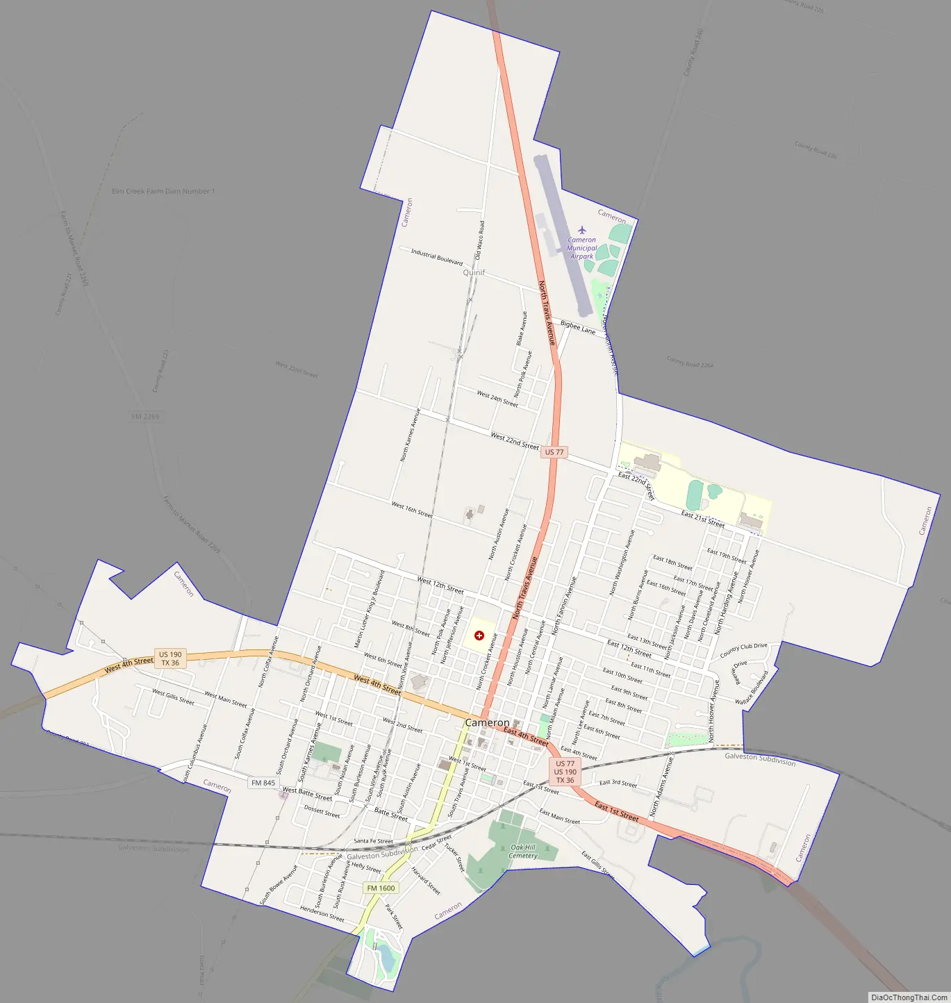
Cameron Road Map
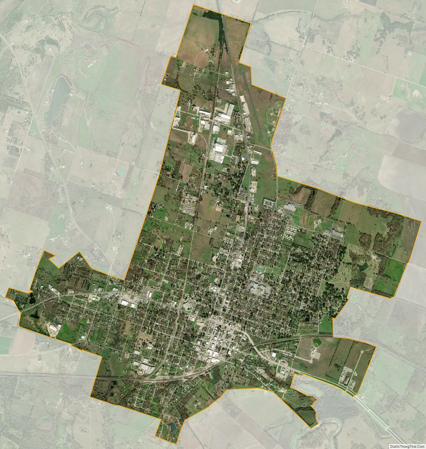
Cameron city Satellite Map
Geography
Cameron is located at 30°51′16″N 96°58′43″W / 30.85444°N 96.97861°W / 30.85444; -96.97861 (30.854544, –96.978716). It is situated at the junction of U.S. Highways 77 and 190, about 71 miles northeast of Austin in north-central Milam County.
According to the United States Census Bureau, the city has a total area of 4.2 square miles (11 km), all land.
See also
Map of Texas State and its subdivision:- Anderson
- Andrews
- Angelina
- Aransas
- Archer
- Armstrong
- Atascosa
- Austin
- Bailey
- Bandera
- Bastrop
- Baylor
- Bee
- Bell
- Bexar
- Blanco
- Borden
- Bosque
- Bowie
- Brazoria
- Brazos
- Brewster
- Briscoe
- Brooks
- Brown
- Burleson
- Burnet
- Caldwell
- Calhoun
- Callahan
- Cameron
- Camp
- Carson
- Cass
- Castro
- Chambers
- Cherokee
- Childress
- Clay
- Cochran
- Coke
- Coleman
- Collin
- Collingsworth
- Colorado
- Comal
- Comanche
- Concho
- Cooke
- Coryell
- Cottle
- Crane
- Crockett
- Crosby
- Culberson
- Dallam
- Dallas
- Dawson
- Deaf Smith
- Delta
- Denton
- Dewitt
- Dickens
- Dimmit
- Donley
- Duval
- Eastland
- Ector
- Edwards
- El Paso
- Ellis
- Erath
- Falls
- Fannin
- Fayette
- Fisher
- Floyd
- Foard
- Fort Bend
- Franklin
- Freestone
- Frio
- Gaines
- Galveston
- Garza
- Gillespie
- Glasscock
- Goliad
- Gonzales
- Gray
- Grayson
- Gregg
- Grimes
- Guadalupe
- Hale
- Hall
- Hamilton
- Hansford
- Hardeman
- Hardin
- Harris
- Harrison
- Hartley
- Haskell
- Hays
- Hemphill
- Henderson
- Hidalgo
- Hill
- Hockley
- Hood
- Hopkins
- Houston
- Howard
- Hudspeth
- Hunt
- Hutchinson
- Irion
- Jack
- Jackson
- Jasper
- Jeff Davis
- Jefferson
- Jim Hogg
- Jim Wells
- Johnson
- Jones
- Karnes
- Kaufman
- Kendall
- Kenedy
- Kent
- Kerr
- Kimble
- King
- Kinney
- Kleberg
- Knox
- La Salle
- Lamar
- Lamb
- Lampasas
- Lavaca
- Lee
- Leon
- Liberty
- Limestone
- Lipscomb
- Live Oak
- Llano
- Loving
- Lubbock
- Lynn
- Madison
- Marion
- Martin
- Mason
- Matagorda
- Maverick
- McCulloch
- McLennan
- McMullen
- Medina
- Menard
- Midland
- Milam
- Mills
- Mitchell
- Montague
- Montgomery
- Moore
- Morris
- Motley
- Nacogdoches
- Navarro
- Newton
- Nolan
- Nueces
- Ochiltree
- Oldham
- Orange
- Palo Pinto
- Panola
- Parker
- Parmer
- Pecos
- Polk
- Potter
- Presidio
- Rains
- Randall
- Reagan
- Real
- Red River
- Reeves
- Refugio
- Roberts
- Robertson
- Rockwall
- Runnels
- Rusk
- Sabine
- San Augustine
- San Jacinto
- San Patricio
- San Saba
- Schleicher
- Scurry
- Shackelford
- Shelby
- Sherman
- Smith
- Somervell
- Starr
- Stephens
- Sterling
- Stonewall
- Sutton
- Swisher
- Tarrant
- Taylor
- Terrell
- Terry
- Throckmorton
- Titus
- Tom Green
- Travis
- Trinity
- Tyler
- Upshur
- Upton
- Uvalde
- Val Verde
- Van Zandt
- Victoria
- Walker
- Waller
- Ward
- Washington
- Webb
- Wharton
- Wheeler
- Wichita
- Wilbarger
- Willacy
- Williamson
- Wilson
- Winkler
- Wise
- Wood
- Yoakum
- Young
- Zapata
- Zavala
- Alabama
- Alaska
- Arizona
- Arkansas
- California
- Colorado
- Connecticut
- Delaware
- District of Columbia
- Florida
- Georgia
- Hawaii
- Idaho
- Illinois
- Indiana
- Iowa
- Kansas
- Kentucky
- Louisiana
- Maine
- Maryland
- Massachusetts
- Michigan
- Minnesota
- Mississippi
- Missouri
- Montana
- Nebraska
- Nevada
- New Hampshire
- New Jersey
- New Mexico
- New York
- North Carolina
- North Dakota
- Ohio
- Oklahoma
- Oregon
- Pennsylvania
- Rhode Island
- South Carolina
- South Dakota
- Tennessee
- Texas
- Utah
- Vermont
- Virginia
- Washington
- West Virginia
- Wisconsin
- Wyoming