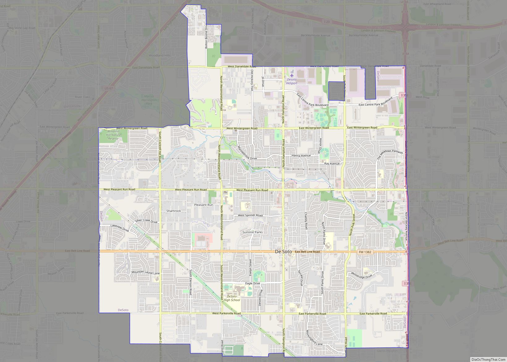
Duncanville is a city in southwest Dallas County, Texas, in the United States. Duncanville’s population was 40,706 at the 2020 census. The city is part of the Best Southwest area, which includes Duncanville, Cedar Hill, DeSoto, and Lancaster.
| Name: | Duncanville city |
|---|---|
| LSAD Code: | 25 |
| LSAD Description: | city (suffix) |
| State: | Texas |
| County: | Dallas County |
| Elevation: | 725 ft (221 m) |
| Land Area: | 11.20 sq mi (29.01 km²) |
| Water Area: | 0.01 sq mi (0.03 km²) |
| Population Density: | 3,459.29/sq mi (1,335.60/km²) |
| ZIP code: | 75116, 75137, 75138 |
| Area code: | 214, 469, 972 |
| FIPS code: | 4821628 |
| GNISfeature ID: | 1334786 |
| Website: | www.duncanville.com |
Online Interactive Map
Click on ![]() to view map in "full screen" mode.
to view map in "full screen" mode.
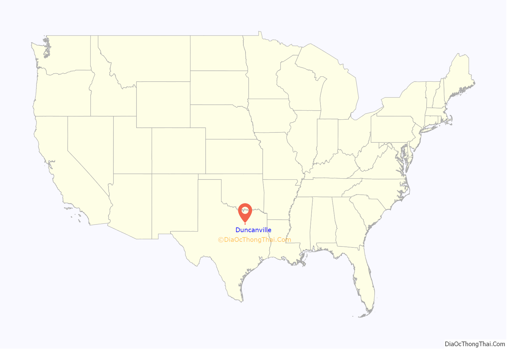
Duncanville location map. Where is Duncanville city?

History
Settlement of the area began in 1845, when Illinois resident Crawford Trees purchased several thousand acres south of Camp Dallas. In 1880, the Chicago, Texas, and Mexican Central Railway reached the area and built Duncan Switch, named for a line foreman. Charles P. Nance, the community’s first postmaster, renamed the settlement Duncanville in 1882. By the late 19th century, Duncanville was home to a dry-goods stores, a pharmacy, a domino parlor, and a school. Between 1904 and 1933, the population of Duncanville increased from 113 to more than 300.
During World War II, the Army Air Corps established a landing field for flight training on property near the present-day intersection of Main St and Wheatland Road.
Duncanville residents incorporated the city on August 2, 1947. During the postwar years, the military developed the Army’s old landing field into the Duncanville Air Force Station, which was the headquarters for the four Nike-Hercules missile launch sites guarding Dallas/Fort Worth from Soviet bomber attack. It also housed the Air Force tracking radars for the region.
When the town’s population reached 5,000 in 1962, citizens adopted a home-rule charter with council-manager city government. Sometimes regarded as a “white flight” suburb in the 1960s and 1970s, the city is now known for its racial diversity. Its population increased from about 13,000 in 1970 to more than 31,000 in 1988.
Historic preservation
The Texas Historical Commission has designated the City of Duncanville as an official Main Street City.
Duncanville recognizes the importance of the former Duncanville Air Force Station, which closed on July 1, 1964, but the Army continued to operate the Nike Missile air defense operations until 1969, when the facility was turned over to the city. The WWII-era barracks and some other structures were initially repurposed for civic and community use. Over time, the buildings were systematically demolished, removing all signs of the historic base, but the history of the facility lives on in a monument that stands outside the library and community center.
The “stone igloo”, a spring house originally located near the intersection of Center Street and Cedar Ridge Road, was preserved in a unique way. In the late 1960s or early 1970s, it was demolished, thereby producing a supply of rocks used to build a replica of the structure at a nearby park and paving the way for the construction of a neighborhood retail center.
Various pieces of the city’s history are preserved at the Duncanville Historical Park, which is located on Wheatland Road in Armstrong Park on land that was once a part of the Duncanville Air Force Station. Historic buildings include the city’s first Music Room.
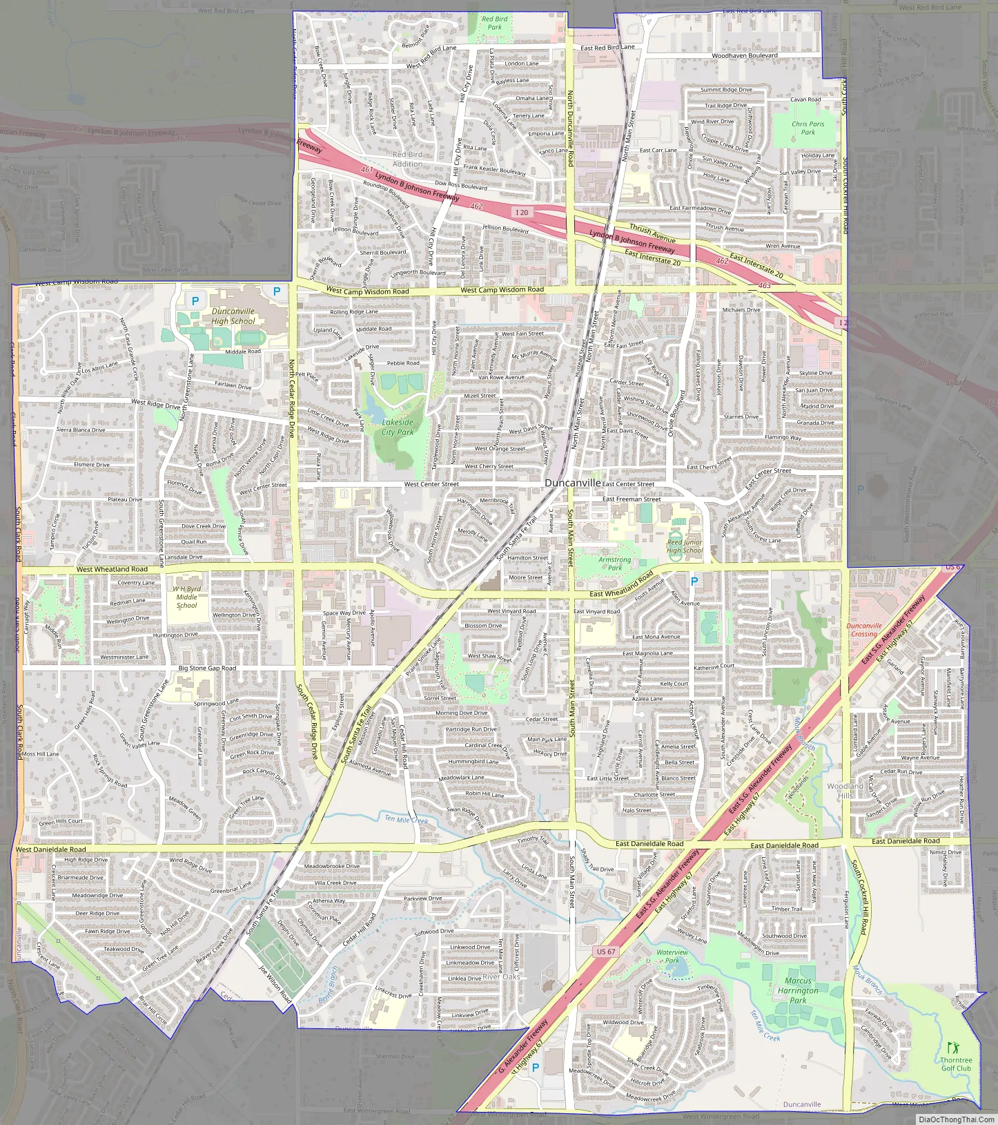
Duncanville Road Map
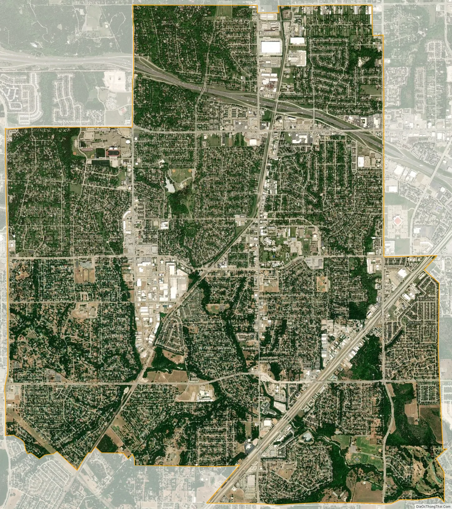
Duncanville city Satellite Map
Geography
Duncanville is located at 32°38′47″N 96°54′41″W / 32.64639°N 96.91139°W / 32.64639; -96.91139 (32.646333, −96.911309).
According to the United States Census Bureau, the city has a total area of 11.3 square miles (29 km), all of it land.
See also
Map of Texas State and its subdivision:- Anderson
- Andrews
- Angelina
- Aransas
- Archer
- Armstrong
- Atascosa
- Austin
- Bailey
- Bandera
- Bastrop
- Baylor
- Bee
- Bell
- Bexar
- Blanco
- Borden
- Bosque
- Bowie
- Brazoria
- Brazos
- Brewster
- Briscoe
- Brooks
- Brown
- Burleson
- Burnet
- Caldwell
- Calhoun
- Callahan
- Cameron
- Camp
- Carson
- Cass
- Castro
- Chambers
- Cherokee
- Childress
- Clay
- Cochran
- Coke
- Coleman
- Collin
- Collingsworth
- Colorado
- Comal
- Comanche
- Concho
- Cooke
- Coryell
- Cottle
- Crane
- Crockett
- Crosby
- Culberson
- Dallam
- Dallas
- Dawson
- Deaf Smith
- Delta
- Denton
- Dewitt
- Dickens
- Dimmit
- Donley
- Duval
- Eastland
- Ector
- Edwards
- El Paso
- Ellis
- Erath
- Falls
- Fannin
- Fayette
- Fisher
- Floyd
- Foard
- Fort Bend
- Franklin
- Freestone
- Frio
- Gaines
- Galveston
- Garza
- Gillespie
- Glasscock
- Goliad
- Gonzales
- Gray
- Grayson
- Gregg
- Grimes
- Guadalupe
- Hale
- Hall
- Hamilton
- Hansford
- Hardeman
- Hardin
- Harris
- Harrison
- Hartley
- Haskell
- Hays
- Hemphill
- Henderson
- Hidalgo
- Hill
- Hockley
- Hood
- Hopkins
- Houston
- Howard
- Hudspeth
- Hunt
- Hutchinson
- Irion
- Jack
- Jackson
- Jasper
- Jeff Davis
- Jefferson
- Jim Hogg
- Jim Wells
- Johnson
- Jones
- Karnes
- Kaufman
- Kendall
- Kenedy
- Kent
- Kerr
- Kimble
- King
- Kinney
- Kleberg
- Knox
- La Salle
- Lamar
- Lamb
- Lampasas
- Lavaca
- Lee
- Leon
- Liberty
- Limestone
- Lipscomb
- Live Oak
- Llano
- Loving
- Lubbock
- Lynn
- Madison
- Marion
- Martin
- Mason
- Matagorda
- Maverick
- McCulloch
- McLennan
- McMullen
- Medina
- Menard
- Midland
- Milam
- Mills
- Mitchell
- Montague
- Montgomery
- Moore
- Morris
- Motley
- Nacogdoches
- Navarro
- Newton
- Nolan
- Nueces
- Ochiltree
- Oldham
- Orange
- Palo Pinto
- Panola
- Parker
- Parmer
- Pecos
- Polk
- Potter
- Presidio
- Rains
- Randall
- Reagan
- Real
- Red River
- Reeves
- Refugio
- Roberts
- Robertson
- Rockwall
- Runnels
- Rusk
- Sabine
- San Augustine
- San Jacinto
- San Patricio
- San Saba
- Schleicher
- Scurry
- Shackelford
- Shelby
- Sherman
- Smith
- Somervell
- Starr
- Stephens
- Sterling
- Stonewall
- Sutton
- Swisher
- Tarrant
- Taylor
- Terrell
- Terry
- Throckmorton
- Titus
- Tom Green
- Travis
- Trinity
- Tyler
- Upshur
- Upton
- Uvalde
- Val Verde
- Van Zandt
- Victoria
- Walker
- Waller
- Ward
- Washington
- Webb
- Wharton
- Wheeler
- Wichita
- Wilbarger
- Willacy
- Williamson
- Wilson
- Winkler
- Wise
- Wood
- Yoakum
- Young
- Zapata
- Zavala
- Alabama
- Alaska
- Arizona
- Arkansas
- California
- Colorado
- Connecticut
- Delaware
- District of Columbia
- Florida
- Georgia
- Hawaii
- Idaho
- Illinois
- Indiana
- Iowa
- Kansas
- Kentucky
- Louisiana
- Maine
- Maryland
- Massachusetts
- Michigan
- Minnesota
- Mississippi
- Missouri
- Montana
- Nebraska
- Nevada
- New Hampshire
- New Jersey
- New Mexico
- New York
- North Carolina
- North Dakota
- Ohio
- Oklahoma
- Oregon
- Pennsylvania
- Rhode Island
- South Carolina
- South Dakota
- Tennessee
- Texas
- Utah
- Vermont
- Virginia
- Washington
- West Virginia
- Wisconsin
- Wyoming